Related Research Articles

An earthquake – also called a quake, tremor, or temblor – is the shaking of the Earth's surface resulting from a sudden release of energy in the lithosphere that creates seismic waves. Earthquakes can range in intensity, from those so weak they cannot be felt, to those violent enough to propel objects and people into the air, damage critical infrastructure, and wreak destruction across entire cities. The seismic activity of an area is the frequency, type, and size of earthquakes experienced over a particular time. The seismicity at a particular location in the Earth is the average rate of seismic energy release per unit volume.

Structural geology is the study of the three-dimensional distribution of rock units with respect to their deformational histories. The primary goal of structural geology is to use measurements of present-day rock geometries to uncover information about the history of deformation (strain) in the rocks, and ultimately, to understand the stress field that resulted in the observed strain and geometries. This understanding of the dynamics of the stress field can be linked to important events in the geologic past; a common goal is to understand the structural evolution of a particular area with respect to regionally widespread patterns of rock deformation due to plate tectonics.
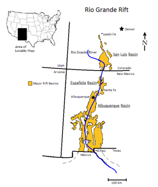
The Rio Grande rift is a north-trending continental rift zone. It separates the Colorado Plateau in the west from the interior of the North American craton on the east. The rift extends from central Colorado in the north to the state of Chihuahua, Mexico, in the south. The rift zone consists of four basins that have an average width of 50 kilometres (31 mi). The rift can be observed on location at Rio Grande National Forest, White Sands National Park, Santa Fe National Forest, and Cibola National Forest, among other locations.

A lithosphere is the rigid, outermost rocky shell of a terrestrial planet or natural satellite. On Earth, it is composed of the crust and the lithospheric mantle, the topmost portion of the upper mantle that behaves elastically on time scales of up to thousands of years or more. The crust and upper mantle are distinguished on the basis of chemistry and mineralogy.

The asthenosphere is the mechanically weak and ductile region of the upper mantle of Earth. It lies below the lithosphere, at a depth between c. 80 and 200 km below the surface, and extends as deep as 700 km (430 mi). However, the lower boundary of the asthenosphere is not well defined.
Subduction is a geological process in which the oceanic lithosphere and some continental lithosphere is recycled into the Earth's mantle at the convergent boundaries between tectonic plates. Where one tectonic plate converges with a second plate, the heavier plate dives beneath the other and sinks into the mantle. A region where this process occurs is known as a subduction zone, and its surface expression is known as an arc-trench complex. The process of subduction has created most of the Earth's continental crust. Rates of subduction are typically measured in centimeters per year, with rates of convergence as high as 11 cm/year.

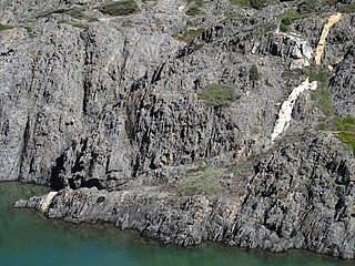
In geology, a fault is a planar fracture or discontinuity in a volume of rock across which there has been significant displacement as a result of rock-mass movements. Large faults within Earth's crust result from the action of plate tectonic forces, with the largest forming the boundaries between the plates, such as the megathrust faults of subduction zones or transform faults. Energy release associated with rapid movement on active faults is the cause of most earthquakes. Faults may also displace slowly, by aseismic creep.
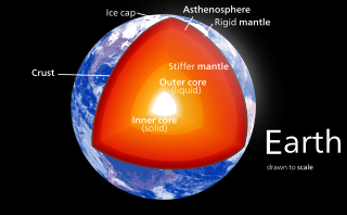
Earth's mantle is a layer of silicate rock between the crust and the outer core. It has a mass of 4.01×1024 kg (8.84×1024 lb) and makes up 67% of the mass of Earth. It has a thickness of 2,900 kilometers (1,800 mi) making up about 46% of Earth's radius and 84% of Earth's volume. It is predominantly solid but, on geologic time scales, it behaves as a viscous fluid, sometimes described as having the consistency of caramel. Partial melting of the mantle at mid-ocean ridges produces oceanic crust, and partial melting of the mantle at subduction zones produces continental crust.

A Wadati–Benioff zone is a planar zone of seismicity corresponding with the down-going slab in a subduction zone. Differential motion along the zone produces numerous earthquakes, the foci of which may be as deep as about 670 km (420 mi). The term was named for the two seismologists, Hugo Benioff of the California Institute of Technology and Kiyoo Wadati of the Japan Meteorological Agency, who independently discovered the zones.
In geology, a shear zone is a thin zone within the Earth's crust or upper mantle that has been strongly deformed, due to the walls of rock on either side of the zone slipping past each other. In the upper crust, where rock is brittle, the shear zone takes the form of a fracture called a fault. In the lower crust and mantle, the extreme conditions of pressure and temperature make the rock ductile. That is, the rock is capable of slowly deforming without fracture, like hot metal being worked by a blacksmith. Here the shear zone is a wider zone, in which the ductile rock has slowly flowed to accommodate the relative motion of the rock walls on either side.
A cataclastic rock is a type of fault rock that has been wholly or partly formed by the progressive fracturing and comminution of existing rocks, a process known as cataclasis. Cataclasis involves the granulation, crushing, or milling of the original rock, then rigid-body rotation and translation of mineral grains or aggregates before lithification. Cataclastic rocks are associated with fault zones and impact event breccias.

The brittle-ductile transition zone is the zone of the Earth's crust that marks the transition from the upper, more brittle crust to the lower, more ductile crust. For quartz and feldspar-rich rocks in continental crust, the transition zone occurs at an approximate depth of 20 km, at temperatures of 250–400 °C. At this depth, rock becomes less likely to fracture, and more likely to deform ductilely by creep because the brittle strength of a material increases with confining pressure, while its ductile strength decreases with increasing temperature.

A detachment fault is a gently dipping normal fault associated with large-scale extensional tectonics. Detachment faults often have very large displacements and juxtapose unmetamorphosed hanging walls against medium to high-grade metamorphic footwalls that are called metamorphic core complexes. They are thought to have formed as either initially low-angle structures or by the rotation of initially high-angle normal faults modified also by the isostatic effects of tectonic denudation. They may also be called denudation faults. Examples of detachment faulting include:
A slow earthquake is a discontinuous, earthquake-like event that releases energy over a period of hours to months, rather than the seconds to minutes characteristic of a typical earthquake. First detected using long term strain measurements, most slow earthquakes now appear to be accompanied by fluid flow and related tremor, which can be detected and approximately located using seismometer data filtered appropriately. That is, they are quiet compared to a regular earthquake, but not "silent" as described in the past.

Cataclasite is a cohesive granular fault rock. Comminution, also known as cataclasis, is an important process in forming cataclasites. They fall into the category of cataclastic rocks which are formed through faulting or fracturing in the upper crust. Cataclasites are distinguished from fault gouge, which is incohesive, and fault breccia, which contains coarser fragments.

Geodynamics is a subfield of geophysics dealing with dynamics of the Earth. It applies physics, chemistry and mathematics to the understanding of how mantle convection leads to plate tectonics and geologic phenomena such as seafloor spreading, mountain building, volcanoes, earthquakes, faulting. It also attempts to probe the internal activity by measuring magnetic fields, gravity, and seismic waves, as well as the mineralogy of rocks and their isotopic composition. Methods of geodynamics are also applied to exploration of other planets.

In Earth science, ductility refers to the capacity of a rock to deform to large strains without macroscopic fracturing. Such behavior may occur in unlithified or poorly lithified sediments, in weak materials such as halite or at greater depths in all rock types where higher temperatures promote crystal plasticity and higher confining pressures suppress brittle fracture. In addition, when a material is behaving ductilely, it exhibits a linear stress vs strain relationship past the elastic limit.

Intraplate deformation is the folding, breaking, or flow of the Earth's crust within plates instead of at their margins. This process usually occurs in areas with especially weak crust and upper mantle, such as the Tibetan Plateau. Intraplate deformation brings another aspect to plate tectonic theory.
Thick-skinned deformation is a geological term which refers to crustal shortening that involves basement rocks and deep-seated faults as opposed to only the upper units of cover rocks above the basement which is known as thin-skinned deformation. While thin-skinned deformation is common in many different localities, thick-skinned deformation requires much more strain to occur and is a rarer type of deformation.

Volcanic and igneous plumbing systems (VIPS) consist of interconnected magma channels and chambers through which magma flows and is stored within Earth's crust. Volcanic plumbing systems can be found in all active tectonic settings, such as mid-oceanic ridges, subduction zones, and mantle plumes, when magmas generated in continental lithosphere, oceanic lithosphere, and in the sub-lithospheric mantle are transported. Magma is first generated by partial melting, followed by segregation and extraction from the source rock to separate the melt from the solid. As magma propagates upwards, a self-organised network of magma channels develops, transporting the melt from lower crust to upper regions. Channelled ascent mechanisms include the formation of dykes and ductile fractures that transport the melt in conduits. For bulk transportation, diapirs carry a large volume of melt and ascent through the crust. When magma stops ascending, or when magma supply stops, magma emplacement occurs. Different mechanisms of emplacement result in different structures, including plutons, sills, laccoliths and lopoliths.
References
- ↑ Scholz, Christopher (2002). The Mechanics of Earthquakes and Faulting. Cambridge University Press. p. 152. ISBN 9780521655408 . Retrieved June 12, 2012.
- ↑ Watts, A.B.; Burov, E.B. (August 2003). "Lithospheric strength and its relationship to the elastic and seismogenic layer thickness". Earth and Planetary Science Letters. 213 (1–2): 113–131. Bibcode:2003E&PSL.213..113W. doi:10.1016/S0012-821X(03)00289-9.
- ↑ Hayes, Gavin; Crone, Tony. "At what depth do earthquakes occur? What is the significance of the depth?". United States Geological Survey.
- ↑ Cole, J.; Hacker, B.; Ratschbacher, L.; Dolan, J.; Seward, G.; Frost, E.; Frank, W. (2007). "Localized ductile shear below the seismogenic zone: Structural analysis of an exhumed strike-slip fault, Austrian Alps" (PDF). Journal of Geophysical Research. 112 (B12): B12304. Bibcode:2007JGRB..11212304C. doi: 10.1029/2007JB004975 .
| | This geophysics-related article is a stub. You can help Wikipedia by expanding it. |
| | This seismology article is a stub. You can help Wikipedia by expanding it. |