
Landslides, also known as landslips, are several forms of mass wasting that may include a wide range of ground movements, such as rockfalls, shallow or deep-seated slope failures, mudflows, and debris flows. Landslides occur in a variety of environments, characterized by either steep or gentle slope gradients, from mountain ranges to coastal cliffs or even underwater, in which case they are called submarine landslides.

A slump is a form of mass wasting that occurs when a coherent mass of loosely consolidated materials or a rock layer moves a short distance down a slope. Movement is characterized by sliding along a concave-upward or planar surface. Causes of slumping include earthquake shocks, thorough wetting, freezing and thawing, undercutting, and loading of a slope.

Skirrid Fawr, often referred to as just the Skirrid, is an easterly outlier of the Black Mountains in Wales. It forms the easternmost part of the Brecon Beacons National Park. The smaller hill of Ysgyryd Fach or "Little Skirrid" (270m) lies about 4.5 km / 2.5 mi to the south.
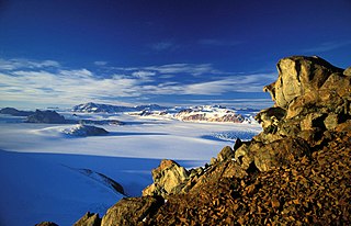
The Transantarctic Mountains comprise a mountain range of uplifted rock in Antarctica which extends, with some interruptions, across the continent from Cape Adare in northern Victoria Land to Coats Land. These mountains divide East Antarctica and West Antarctica. They include a number of separately named mountain groups, which are often again subdivided into smaller ranges.

Hatherton Glacier is a large glacier flowing from the Antarctic polar plateau generally eastward along the south side of the Darwin Mountains and entering Darwin Glacier at Junction Spur. It was mapped by the Darwin Glacier Party of the Commonwealth Trans-Antarctic Expedition (1956–58), and was named for Trevor Hatherton, Scientific Officer in Charge of Antarctic Activities at the Department of Scientific and Industrial Research, Wellington, New Zealand.

Socompa is a large stratovolcano at the border of Argentina and Chile with an elevation of 6,051 metres (19,852 ft) metres. Part of the Chilean and Argentine Andean Volcanic Belt (AVB), it is part of the Central Volcanic Zone, one of the various segments of the AVB. This part of the Andean volcanic arc begins in Peru and runs first through Bolivia and Chile, and then through Argentina and Chile, and contains about 44 active volcanoes. Socompa lies close to the pass of the same name, where the Salta-Antofagasta railway crosses the border.
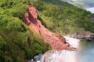
A rockslide is a type of landslide caused by rock failure in which part of the bedding plane of failure passes through compacted rock and material collapses en masse and not in individual blocks. Note that a rockslide is similar to an avalanche because they are both slides of debris that can bury a piece of land. While a landslide occurs when loose dirt or sediment falls down a slope, a rockslide occurs only when solid rocks are transported down slope. The rocks tumble downhill, loosening other rocks on their way and smashing everything in their path. Fast-flowing rock slides or debris slides behave similarly to snow avalanches, and are often referred to as rock avalanches or debris avalanches.


A mudflow, also known as mudslide or mud flow, is a form of mass wasting involving fast-moving flow of debris and dirt that has become liquified by the addition of water. Such flows can move at speeds ranging from 3 meters/minute to 5 meters/second. Mudflows contain a significant proportion of clay, which makes them more fluid than debris flows, allowing them to travel farther and across lower slope angles. Both types of flow are generally mixtures of particles with a wide range of sizes, which typically become sorted by size upon deposition.

Rock glaciers are distinctive geomorphological landforms, consisting either of angular rock debris frozen in interstitial ice, former "true" glaciers overlain by a layer of talus, or something in-between. Rock glaciers are normally found at high latitudes and/or elevations, and may extend outward and downslope from talus cones, glaciers or terminal moraines of glaciers.
Bukit Antarabangsa is a hillside township located in Ulu Klang, Ampang District, Selangor, Malaysia. The area is well known for being an affluent residential suburb occupied by occasional celebrities and political figures alike.

The geology of Antarctica covers the geological development of the continent through the Archean, Proterozoic and Phanerozoic eons.

Dracovenator is a genus of neotheropod dinosaur that lived approximately 201 to 199 million years ago during the early part of the Jurassic Period in what is now South Africa. Dracovenator was a medium-sized, moderately-built, ground-dwelling, bipedal carnivore, that could grow up to an estimated 5.5–6.5 metres (18–21 ft) in length and 250 kilograms (550 lb) in body mass. Its type specimen was based on only a partial skull that was recovered.
There have been known various classifications of landslides. Broad definitions include forms of mass movement that narrower definitions exclude. For example, the McGraw-Hill Encyclopedia of Science and Technology distinguishes the following types of landslides:

The Scott Glacier is a major glacier, 120 miles (190 km) long, that drains the East Antarctic Ice Sheet through the Queen Maud Mountains to the Ross Ice Shelf. The Scott Glacier is one of a series of major glaciers flowing across the Transantarctic Mountains, with the Amundsen Glacier to the west and the Leverett and Reedy glaciers to the east.

SWEAT is the hypothesis that the Southwestern United States was at one time connected to East Antarctica.

Oscar II Coast is that portion of the east coast of the Antarctic Peninsula between Cape Fairweather to the north, and Cape Alexander to the south. Discovered in 1893 by Captain C.A. Larsen, who named it for King Oscar II of Norway and Sweden. To the north of this coast is Nordenskjöld Coast.
Molar Massif is a large mountain massif immediately east of the Lanterman Range in the Bowers Mountains of Antarctica. It was mapped by the United States Geological Survey from ground surveys and U.S. Navy air photos, 1960–1964. The descriptive name was applied by the Advisory Committee on Antarctic Names; when viewed in plan, the outline of the massif resembles a molar tooth.

The tectonic evolution of the Transantarctic Mountains appears to have begun when Antarctica broke away from Australia during the late Cretaceous and is ongoing, creating along the way some of the longest mountain ranges formed by rift flank uplift and associated continental rifting. The Transantarctic Mountains (TAM) separate East and West Antarctica. The rift system that formed them is caused by a reactivation of crust along the East Antarctic Craton. This rifting or seafloor spreading causes plate movement that results in a nearby convergent boundary which then forms the mountain range. The exact processes responsible for making the Transantarctic Mountains are still debated today. This results in a large variety of proposed theories that attempt to decipher the tectonic history of these mountains.
