Lanao del Norte, officially the Province of Lanao del Norte, is a province in the Philippines located in the Northern Mindanao region. Its capital is Tubod.

Lanao del Sur, officially the Province of Lanao del Sur, is a province in the Philippines located in the Bangsamoro Autonomous Region in Muslim Mindanao (BARMM). The capital is the city of Marawi, and it borders Lanao del Norte to the north, Bukidnon to the east, and Maguindanao del Norte and Cotabato to the south. To the southwest lies Illana Bay, an arm of the Moro Gulf.
Marawi, officially the Islamic City of Marawi, is a 4th class component city and capital of the province of Lanao del Sur, Philippines. According to the 2020 census, it has a population of 207,010 people.
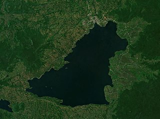
Lake Lanao is a large ancient lake in the province of Lanao del Sur, Philippines. With a surface area of 340 km2 (130 sq mi), it is the largest lake in Mindanao, the deepest and second largest lake in the Philippines, and counted as one of the 15 ancient lakes in the world. Scholars have been pushing for the lake's inclusion in the UNESCO World Heritage List. The lake's native people call themselves the Maranao or Meranaw. Their name was derived from the name of the lake, meaning "the people living around the lake".

Balindong, officially the Municipality of Balindong, is a 4th class municipality in the province of Lanao del Sur, Philippines. According to the 2020 census, it has a population of 32,573 people.

Masiu, officially the Municipality of Masiu, is a 5th class municipality in the province of Lanao del Sur, Philippines. According to the 2020 census, it has a population of 33,580 people.

Saguiaran, officially the Municipality of Saguiaran, is a 4th class municipality in the province of Lanao del Sur, Philippines. According to the 2020 census, it has a population of 26,712 people.

Tamparan, officially the Municipality of Tamparan, is a 5th class municipality in the province of Lanao del Sur, Philippines. According to the 2020 census, it has a population of 32,074 people.

Pantar, officially the Municipality of Pantar, is a 5th class municipality in the province of Lanao del Norte, Philippines. According to the 2020 census, it has a population of 26,599 people.

Pantao Ragat, officially the Municipality of Pantao Ragat, is a 4th class municipality in the province of Lanao del Norte, Philippines. According to the 2020 census, it has a population of 30,247 people.

Poona Piagapo, officially the Municipality of Poona Piagapo, is a 4th class municipality in the province of Lanao del Norte, Philippines. According to the 2020 census, it has a population of 29,183 people.

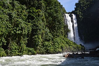
The Agus River is a river that flows for 36.5 kilometres (22.7 mi) from Lanao Lake to Iligan Bay, Philippines. It cuts through the provinces of Lanao del Sur and Lanao del Norte. Settlements along the banks of the river include the City of Marawi, the Municipality of Linamon, and the City of Iligan. It separates into two channels as it drains to Iligan Bay; one goes over the Maria Cristina Falls while the other supplies the Tinago Falls. The river descends for about 2,200 feet (670 m) from its source as it flows for 21 miles (34 km) before draining to the sea. The river is relatively shallow as it is only 4 feet (1.2 m) deep in some areas. The Agus River's watershed spans about 11,320.00 hectares. In 1992, the National Power Corporation financed the reforestation of the Lake Lanao-Agus River watershed, planting over 1500 hectares of Acacia mangium, Durio zibethinus, and other indigenous trees. It has a discharge of about 10 cubic metres per second (350 cu ft/s) and flows from a narrow depression off the northwestern rim of the lake and flows over a basalt rock formation. The canyon carved by the river suggests a short erosional period.
The legislative districts of Lanao del Norte are the representations of the province of Lanao del Norte in the various national legislatures of the Philippines. The province is currently represented in the lower house of the Congress of the Philippines through its first and second congressional districts.

Lake Dapao is a deep water lake located in the province of Lanao del Sur, southwest of Lake Lanao, in the island of Mindanao in the Philippines. It is one of the deepest lakes in the country, reaching a maximum depth of 120 metres (390 ft). It has an estimated surface area of 1,011 hectares (10.11 km2). The lake receives water from local run-off and several small rivers.
Sacred Mountain National Park is a national park in Marawi, Lanao del Sur in the Southern Philippines. The 94-hectare (230-acre) national park and protected area, located in Brgys. Guimba and Papandayan, was established on August 5, 1965, by Republic Act no. 4190. The main geographic feature of the park is Mount Mupo which has the height of 274.32-meter (900.0 ft). Activities in the park include birdwatching and trekking to the mountaintop where a pond is located.
Lake Butig National Park is a protected area of the Philippines located in the municipality of Butig, Lanao del Sur in Mindanao Island. The park spans an area of 68 hectares comprising Lake Butig and its surrounding forest. It was declared a national park in 1965 by virtue of Republic Act No. 4190.
Rungkunan National Park is a protected area of the Philippines located in the municipalities of Ditsaan-Ramain and Tagoloan II in Lanao del Sur, some 10 kilometers east-south-east of the provincial capital Marawi. The park covers the mountainous eastern section of Lanao del Sur near the Lake Lanao-Agus River Watershed Area known for its beautiful sparkling stream, virgin forest and invigorating climate. It was declared a national park in 1965 by virtue of Republic Act No. 4190.
Salikata National Park is a protected area of the Philippines located in the municipality of Lumba-Bayabao, Lanao del Sur in Mindanao Island. Nestled in the thickly forested foothills of the Mount Ragang range, the park is one of the six national parks in the province of Lanao del Sur declared in 1965. The area is characterized by waterfalls, river gorge, rocky cliffs and dense canopy stretching the length of the Gata River valley from barangay Salaman to Mapantao near the provincial border with Cotabato.

Saidamen Balt Pangarungan is a Filipino businessman, lawyer and politician who previously served as the ad interim Chairman of the Commission on Elections from March–June 2022. He previously served as the secretary of the National Commission on Muslim Filipinos in the Duterte administration, and was the governor of Lanao del Sur from 1988 to 1992.
Pantao is the name of several barangays in the Philippines:

