
Protected areas of South Australia, consisting of protected areas located within South Australia and its immediate onshore waters and which are managed by South Australian Government agencies. As of 2018, South Australia contained 359 separate protected areas declared under the National Parks and Wildlife Act 1972, the Crown Land Management Act 2009 and the Wilderness Protection Act 1992. Together, they cover a total land area of 211,387.48 km2 (81,617.16 sq mi) or 21.5% of the state's area.

A nature reserve is a protected area of importance for flora, fauna, funga, or features of geological or other special interest, which is reserved and managed for purposes of conservation and to provide special opportunities for study or research. They may be designated by government institutions in some countries, or by private landowners, such as charities and research institutions. Nature reserves fall into different IUCN categories depending on the level of protection afforded by local laws. Normally it is more strictly protected than a nature park. Various jurisdictions may use other terminology, such as ecological protection area or private protected area in legislation and in official titles of the reserves.

Isabela, officially the Province of Isabela, is the second largest province in the Philippines in land area located in the Cagayan Valley. Its capital and the largest local government unit is the city of Ilagan. It is bordered by the provinces of Cagayan to the north, Kalinga to the northwest, Mountain Province to the central-west, Ifugao and Nueva Vizcaya to the southwest, Quirino, Aurora and the independent city of Santiago to the south, and the Philippine Sea to the east.
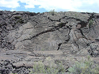
El Malpais National Monument is a National Monument located in western New Mexico, in the Southwestern United States. The name El Malpais is from the Spanish term Malpaís, meaning badlands, due to the extremely barren and dramatic volcanic field that covers much of the park's area.

Mount Banahaw is an active complex volcano on Luzon in the Philippines. The three-peaked volcano is located at the boundary of Laguna and Quezon provinces. It is the highest mountain in both provinces and Calabarzon region, dominating the landscape for miles around.

Ilagan, officially the City of Ilagan, is a 1st class component city and capital of the province of Isabela, Philippines. According to the 2020 census, it has a population of 158,218 people making it the most populous city in the province and the second most-populous in Cagayan Valley after Tuguegarao. As of 2022, it also had the most number of voters in the province with 101,050 electorates.

Palanan, officially the Municipality of Palanan, is a 1st class municipality in the province of Isabela, Philippines. It also served as the final capital of the First Philippine Republic from 1900 until the capture of President Emilio Aguinaldo by the Americans during the Philippine-American War in 1901. According to the 2020 census, it has a population of 17,684 people.
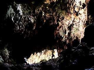
Callao Cave is one of 300 limestone caves located in the Barangays of Magdalo and Quibal in the municipality of Peñablanca, about 24 km (15 mi) northeast of Tuguegarao City, the capital of Cagayan province within the Peñablanca Protected Landscape and Seascape in the western foothills of the Northern Sierra Madre Mountains on Luzon island in the Philippines. The town Peñablanca's name refers to the predominance of white limestone rock formations in the area. First excavated in 1980 by Maharlika Cuevas, the seven-chamber show cave is the best known natural tourist attraction of the Cagayan province and in February 2020 has officially been recognized as an important cultural property of the Philippines.

Pagsanjan Falls, also known as Cavinti Falls, is one of the most famous waterfalls in the Philippines. Located in the province of Laguna, the falls is one of the major tourist attractions of the region. The three-drop waterfall is reached by a river trip on dugout canoe, known locally as "Shooting the Rapids", originating from the municipality of Pagsanjan. The falls can also be reached from the top by a short hike from Cavinti.
Mahagnao Volcano also known as part of is a dormant stratovolcano located in the Barangay Mahagnao part of the municipality of Burauen province of Leyte, Philippines. It is also bounded by the municipalities of La Paz and MacArthur. The area is mostly composed of wetland forests and also the birth of many rivers and streams flowing on many part of Burauen and on its neighboring towns.
The Bulusan Volcano Natural Park is a 3,673-hectare (9,080-acre) protected area of rainforest surrounding Mount Bulusan in the Philippines. It was first designated as a National Park by Proclamation no. 811 on June 7, 1935. Under the National Integrated Protected Areas System (NIPAS) of 1992 managed by the Department of the Environment and Natural Resources, the park was reclassified as a Natural Park by Proc. 421 on November 27, 2000. The area features the volcano itself, Bulusan Lake, the two other mountains known as the 'Sharp Peak' and 'Hormahan' and Lake Aguingay. The park is in the south central part of Sorsogon Province, southern Luzon, Bicol Region, Philippines, bounded by five municipalities: Bulusan, Barcelona, Irosin, Juban and Casiguran.

Biak-na-Bato National Park is a protected area of the Philippines located almost entirely within Barangay Biak-na-Bato in San Miguel, Bulacan from where it derives its name. The park also extends to the nearby municipalities of San Ildefonso and Doña Remedios Trinidad covering a total area of 2,117 hectares. It was declared a national park in 1937 by President Manuel L. Quezon by virtue of its association with the history and site of the Biak-na-Bato Republic. The park consists of a cave network and a system of rivers and trails of both historical and ecological importance. Situated only 80 kilometers (50 mi) northeast from Manila, it is fast becoming a popular weekend eco-adventure destination for the city dwellers.

Balbalasang–Balbalan National Park is a protected area of the Philippines located in the municipality of Balbalan, Kalinga in the Cordillera Administrative Region. The park covers an area of 1,338 hectares and is centered on Mount Balbalasang in the barangay of the same name near the provincial border with Abra. Dubbed the "green heart of the Cordillera", the park is representative of the rich biodiversity and landscape of this mountain region with some of the most intact pine forests and richly endemic flora and fauna. It was declared a national park in 1972 by virtue of Republic Act No. 6463.
Guadalupe Mabugnao Mainit Hot Spring National Park is a protected area of the Philippines located in Barangay Guadalupe in Carcar, Cebu, approximately 50 kilometers from the provincial capital, Cebu City. The park covers an area of 57.50 hectares, occupying an important watershed forest reserve in the central Mantalongon mountain range. It was declared a national park in 1972 by virtue of Republic Act No. 6429.

Minalungao National Park is a protected area of the Philippines located in the municipality of General Tinio, Nueva Ecija, near its Boundary with Doña Remedios Trinidad, Bulacan. The park covers an area of 2,018 hectares centered along the scenic Peñaranda River bordered on both sides by up to 16-meter high limestone walls in the foothills of the Sierra Madre mountain range. It was established in 1967 by virtue of Republic Act No. 5100.

The Bulabog Putian National Park is a protected wildlife and natural park located in the towns of Dingle and San Enrique in the province of Iloilo on the island of Panay in the Western Visayas region. The park covers an area of 854.33 hectares along a 40 kilometers (25 mi) trail in this rainforest. It was established in 1961 through Proclamation No. 760 signed by President Carlos P. Garcia. The park is known for its unique geological formation and is the only limestone mountain formation in Iloilo. It is also known as the location of the Cry of Lincud that started the Philippine Revolution in Iloilo in 1898.

Cassamata Hill National Park is a protected area of the Philippines located in the municipality of Bangued, Abra in the Cordillera Administrative Region. The park covers an area of 57 hectares (140 acres) and was declared a protected area in 1974.

The Peñablanca Protected Landscape and Seascape is a protected area and national park in Peñablanca, Cagayan. It is on the border with Isabela province, contiguous with the Northern Sierra Madre Natural Park. The protected area, best known as the location of Callao Cave, covers the largest block of forest under conservation in the province. It covers 118,781.582 hectares of the northern Sierra Madre mountain range and its adjacent Pacific coast.

The Northern Sierra Madre Natural Park is the largest protected area of the Philippines covering the northern range of the Sierra Madre mountains of eastern Luzon. The park is located in the eastern part of the province of Isabela in Cagayan Valley containing a total of 359,486 hectares. It was first declared a wilderness reserve encompassing an area within a 45 kilometres (28 mi) radius of Palanan Point known as the Palanan Wilderness Area through Letter of Instructions No. 917-A signed by President Ferdinand Marcos on September 7, 1979. On March 10, 1997, the area was converted into a natural park with the signing of Proclamation No. 978 by President Fidel Ramos.

The Sierra Madre is the longest mountain range in the Philippines. Spanning over 540 kilometers (340 mi), it runs from the province of Cagayan down to the province of Quezon, forming a north–south direction on the eastern portion of Luzon, the largest island of the archipelago. It is bordered by the Pacific Ocean to the east, Cagayan Valley to the northwest, Central Luzon to the midwest, and Calabarzon to the southwest. Some communities east of the mountain range, along the coast, are less developed and so remote that they could only be accessed by taking a plane or a boat.
