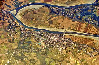
The Cagayan River, also known as the Río Grande de Cagayán, is the longest river and the largest river by discharge volume of water in the Philippines. It has a total length of approximately 505 kilometres (314 mi) and a drainage basin covering 27,753 square kilometres (10,715 sq mi). It is located in the Cagayan Valley region in northeastern part of Luzon Island and traverses the provinces of Nueva Vizcaya, Quirino, Isabela and Cagayan.

Isabela, officially the Province of Isabela, is the second largest province in the Philippines in land area located in the Cagayan Valley region. Its capital and the largest local government unit is the city of Ilagan. It is bordered by the provinces of Cagayan to the north, Kalinga to the northwest, Mountain Province to the central-west, Ifugao and Nueva Vizcaya to the southwest, Quirino and Aurora to the south, and the Philippine Sea to the east.
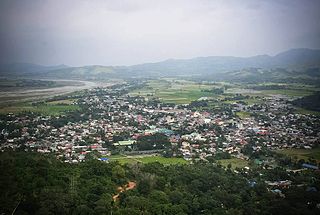
Nueva Vizcaya, officially the Province of Nueva Vizcaya, is a landlocked province in the Philippines located in the Cagayan Valley region in Luzon. Its capital is Bayombong. It is bordered by Benguet to the west, Ifugao to the north, Isabela to the northeast, Quirino to the east, Aurora to the southeast, Nueva Ecija to the south, and Pangasinan to the southwest. Quirino province was created from Nueva Vizcaya in 1966.
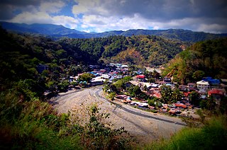
Bambang, officially the Municipality of Bambang, is a 1st class municipality in the province of Nueva Vizcaya, Philippines. According to the 2020 census, it has a population of 55,789 people.

Kitanglad Mountain Range is a mountain range that dominates the northern central portion of the province of Bukidnon. It occupies portions of eight of the municipalities and cities in the province such as Talakag, Baungon, Libona, Manolo Fortich, Impasugong, Lantapan and Malaybalay. The range is one of the few remaining rainforests in the Philippines, hosting one of the most important diverse species of rare and endemic wildlife such as the Philippine eagle. Five of its peaks have very high elevations: Mount Dulang-dulang, the highest at 2,941 m (9,649 ft); Mount Kitanglad at 2,899 meters; Mount Maagnaw at 2,742 meters; Mount Lumuluyaw at 2,612 meters; and Mount Tuminungan at 2,400 meters.

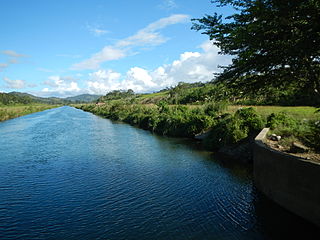
The Magat River is a river in the Philippine island of Luzon with a total length of 226 kilometres (140 mi). It originates in the Nueva Vizcaya municipality of Aritao, where the Santa Fe River joins the Marang. It is the largest tributary of the Cagayan River by discharge volume of water, with an estimated drainage area of 5,200 square kilometres (2,000 sq mi), roughly twenty percent of the total drainage area of the Cagayan River.

The Bulabog Putian National Park is a protected wildlife and natural park located in the towns of Dingle and San Enrique in the province of Iloilo on the island of Panay in the Western Visayas region. The park covers an area of 854.33 hectares along a 40 kilometers (25 mi) trail in this rainforest. It was established in 1961 through Proclamation No. 760 signed by President Carlos P. Garcia. The park is known for its unique geological formation and is the only limestone mountain formation in Iloilo. It is also known as the location of the Cry of Lincud that started the Philippine Revolution in Iloilo in 1898.

The Peñablanca Protected Landscape and Seascape is a protected area and national park in Peñablanca, Cagayan. It is on the border with Isabela province, contiguous with the Northern Sierra Madre Natural Park. The protected area, best known as the location of Callao Cave, covers the largest block of forest under conservation in the province. It covers 118,781.582 hectares of the northern Sierra Madre mountain range and its adjacent Pacific coast.

The Northern Sierra Madre Natural Park is the largest protected area of the Philippines covering the northern range of the Sierra Madre mountains of eastern Luzon. The park is located in the eastern part of the province of Isabela in Cagayan Valley containing a total of 359,486 hectares. It was first declared a wilderness reserve encompassing an area within a 45 kilometres (28 mi) radius of Palanan Point known as the Palanan Wilderness Area through Letter of Instructions No. 917-A signed by President Ferdinand Marcos on September 7, 1979. On March 10, 1997, the area was converted into a natural park with the signing of Proclamation No. 978 by President Fidel Ramos.
The Mount Inayawan Range Natural Park is a protected area of forested mountains in the Northern Mindanao region of the Philippines. The park encompasses the mountain range also known as Mount Iniaoan located in the landlocked municipality of Nunungan in Lanao del Norte and covers a total area of 3,632.74 hectares with a buffer zone of 889.04 hectares. The area was officially designated as a natural park on 30 July 2007 through Proclamation No. 1344 signed by President Gloria Arroyo. It is a critical watershed area and the largest remaining rainforest in Lanao del Norte.

The Roosevelt Protected Landscape, also known as Roosevelt Park, is a protected area in the Central Luzon region in the Philippines. It occupies an area of 786.04 hectares of grasslands and old-growth forest in northern Bataan province near Olongapo and the Subic Bay Freeport Zone. The park was established as Roosevelt National Park covering an area of 1,485 hectares on 30 March 1933 through Proclamation No. 567 signed by Governor-General Theodore Roosevelt, Jr. In 1965, the national park was reduced to 1,334 hectares. On 23 April 2000, the park was reclassified as a protected landscape area and was further reduced to its present area of 786.04 hectares.

The Magapit Protected Landscape is a protected area of forested limestone hills and grasslands in the Cagayan Valley of northern Luzon island in the Philippines. It covers an area of 3,403.62 hectares in northeastern Cagayan province straddling the municipalities of Lal-lo and Gattaran. The park was established as a game refuge and bird sanctuary on 15 August 1947 covering an initial area of 4,554 hectares declared through Administrative Order No. 10 by President Manuel Roxas. On 23 April 2000, the park was redesignated as a protected landscape area under the National Integrated Protected Areas System Act through Proclamation No. 285 signed by President Joseph Estrada. The park is a component of the Northeastern Cagayan Key Biodiversity Area and also contains the Lal-lo and Gattaran Shell Middens, a proposed World Heritage Site.
The Casecnan Protected Landscape is a protected area in the Casecnan River watershed of eastern Luzon in the Philippines. It has a total area of 88,846.80 hectares straddling the provinces of Nueva Vizcaya, Quirino and Aurora. The 57,930-hectare (143,100-acre) Casecnan River Watershed Forest Reserve was established in August 1987 by virtue of Executive Order No. 136 issued by President Corazon Aquino. In April 2000, the forest reserve was enlarged to 88,846.80 hectares and was reclassified as a protected landscape area through Proclamation No. 289. It is considered one of the last remaining substantial water sources for the region of Central Luzon.
The Mount Timolan Protected Landscape is a protected area covering Mount Timolan and its surrounding forested landscape in the region of Zamboanga Peninsula on Mindanao in the Philippines. The park encompasses an area of 1,994.79 hectares and a buffer zone of 695.39 hectares in the municipalities of San Miguel, Guipos and Tigbao in the province of Zamboanga del Sur. It was established on 14 August 2000 through Proclamation Order No. 354 issued by President Joseph Estrada. The park was also earlier established by the provincial government of Zamboanga del Sur as a provincial park and wildlife sanctuary known as the Zamboanga del Sur Provincial Park through Provincial Ordinance No. 3 in 1992.
The Libunao Protected Landscape, also known as the Libunao Spring Protected Landscape, is a protected area in the Ilocos Region of the island of Luzon in the Philippines located on the western foothills of the Ilocos Mountain Range. It protects the Libunao Spring and surrounding forests, as well as the Nagcullooban River watershed. First proclaimed as the Libunao Spring Watershed Forest Reserve in 1931 through Proclamation No. 410 issued by Governor-General Dwight F. Davis, the park was reestablished as a protected landscape area under the National Integrated Protected Areas System in 2000 through Proclamation No. 280 signed by President Joseph Estrada. The Libunao watershed is the source of water supply for domestic use and irrigation of the surrounding farms and communities of northern Ilocos Sur province.

The Pasonanca Natural Park is a protected area that preserves a major watershed in the southern Philippine island of Mindanao in the Zamboanga Peninsula. It contains the headwaters of the Tumaga River in the southern Zamboanga Cordillera mountain range that serves the water requirements of some 800,000 residents in Zamboanga City. It was named after the village of Pasonanca located in the city's northern fringes where the Pasonanca Park, a public eco-park, and the Abong-Abong Park, a pilgrimage site, can also be found.
The Mimbilisan Protected Landscape is a protected landscape area located in the province of Misamis Oriental in Northern Mindanao in the Philippines. It was established in 1936 to protect the watershed forest surrounding the Mimbilisan Falls in the municipality of Talisayan declared through Proclamation No. 51 by President Manuel Luis Quezon. It had an initial area of 72 hectares and is an important source for Mimbilisan Water System that supplies water to the surrounding communities in eastern Misamis Oriental. In 1999 and again, in 2007, the forest reserve was reestablished as a protected landscape under the National Integrated Protected Areas System with the enactment of Proclamation No. 134 and Republic Act No. 9494. It is one of five declared protected areas of the Philippines in Misamis Oriental.

The Sierra Madre is the longest mountain range in the Philippines. Spanning over 540 kilometers (340 mi), it runs from the province of Cagayan down to the province of Quezon, forming a north–south direction on the eastern portion of Luzon, the largest island of the archipelago. It is bordered by the Pacific Ocean to the east, Cagayan Valley to the northwest, Central Luzon to the midwest, and Calabarzon to the southwest. Some communities east of the mountain range, along the coast, are less developed and so remote that they could only be accessed by taking a plane or a boat.

The Upper Agno River Basin Resource Reserve is a protected area located on the southeast flank of the Cordillera Central in the Philippine province of Benguet along its border with Ifugao and Nueva Vizcaya. It is a resource reserve located high in the Central and Polis ranges protecting the headwaters of the Agno River. According to section 4 of the National Integrated Protected Areas System Act, a resource reserve is an extensive and relatively isolated area designated as such to preserve the natural resources of the area. The reserve comprises 77,561 hectares of the catchment area that feeds the Ambuklao and Binga dams, two of the country's oldest hydroelectric plants that supply power to the city of Baguio and entire Benguet province. Upper Agno is north of and contiguous with the Lower Agno Watershed Forest Reserve that preserves the immediate downstream of the Binga Dam where the Agno River is impounded by a third dam, the San Roque Dam, the largest in the Philippines and the main source of water, electric energy and irrigation for surrounding regions in Luzon.


