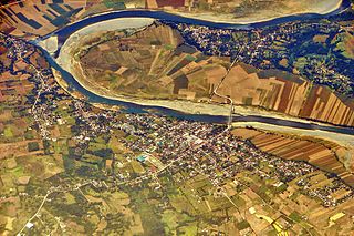
The Cagayan River, also known as the Río Grande de Cagayán, is the longest river and the largest river by discharge volume of water in the Philippines. It has a total length of approximately 505 kilometres (314 mi) and a drainage basin covering 27,753 square kilometres (10,715 sq mi). It is located in the Cagayan Valley region in northeastern part of Luzon Island and traverses the provinces of Nueva Vizcaya, Quirino, Isabela and Cagayan.

Cagayan Valley, designated as Region II, is an administrative region in the Philippines, located in the northeastern section of Luzon Island. It is composed of five Philippine provinces: Batanes, Cagayan, Isabela, Nueva Vizcaya, and Quirino. The region hosts four chartered cities of Cauayan, Ilagan, Santiago, and Tuguegarao.
Aurora is a province in the Philippines located in the eastern part of Central Luzon region, facing the Philippine Sea. Its capital is Baler and borders, clockwise from the south, the provinces of Quezon, Bulacan, Nueva Ecija, Nueva Vizcaya, Quirino, and Isabela.

Nueva Vizcaya, officially the Province of Nueva Vizcaya, is a landlocked province in the Philippines located in the Cagayan Valley region in Luzon. Its capital is Bayombong. It is bordered by Benguet to the west, Ifugao to the north, Isabela to the northeast, Quirino to the east, Aurora to the southeast, Nueva Ecija to the south, and Pangasinan to the southwest. Quirino province was created from Nueva Vizcaya in 1966.

Quirino, is a landlocked province in the Philippines located in the Cagayan Valley region in Luzon. Its capital is Cabarroguis. It is named after Elpidio Quirino, the sixth President of the Philippines.

The Caraballo Mountains is a mountain range in the central part of Luzon island in the Philippines, situated between the Cordillera Central and Sierra Madre mountain ranges. The mountains serve as the location of the headwaters of the Cagayan River, the longest in the country.

Casecnan Irrigation and Hydroelectric Plant is a dam diverting water from the Casecnan and Taan Rivers to the Pantabangan Reservoir through a 26-kilometre (16 mi) long tunnel located near Pantabangan and Muñoz in Nueva Ecija province of the Philippines. The multi-purpose dam provides water for irrigation and hydroelectric power generation while its reservoir affords flood control. It was considered one of the most expensive hydroelectric plants built in the country, being next only to San Roque Dam.

The Northern Sierra Madre Natural Park is the largest protected area of the Philippines covering the northern range of the Sierra Madre mountains of eastern Luzon. The park is located in the eastern part of the province of Isabela in Cagayan Valley containing a total of 359,486 hectares. It was first declared a wilderness reserve encompassing an area within a 45 kilometres (28 mi) radius of Palanan Point known as the Palanan Wilderness Area through Letter of Instructions No. 917-A signed by President Ferdinand Marcos on 7 September 1979. On 10 March 1997, the area was converted into a natural park with the signing of Proclamation No. 978 by President Fidel Ramos.

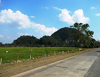
The Magapit Protected Landscape is a protected area of forested limestone hills and grasslands in the Cagayan Valley of northern Luzon island in the Philippines. It covers an area of 3,403.62 hectares in northeastern Cagayan province straddling the municipalities of Lal-lo and Gattaran. The park was established as a game refuge and bird sanctuary on 15 August 1947 covering an initial area of 4,554 hectares declared through Administrative Order No. 10 by President Manuel Roxas. On 23 April 2000, the park was redesignated as a protected landscape area under the National Integrated Protected Areas System Act through Proclamation No. 285 signed by President Joseph Estrada. The park is a component of the Northeastern Cagayan Key Biodiversity Area and also contains the Lal-lo and Gattaran Shell Middens, a proposed World Heritage Site.

The Salinas Natural Monument is a natural monument comprising saline springs and forested mountains in southern Cagayan Valley in the Philippines. It is one of four protected areas in the landlocked province of Nueva Vizcaya spanning an area of 6,675.56 hectares in the municipalities of Bambang, Kayapa and Aritao. The park was established on 18 May 1914 as the Salinas Forest Reserve covering the Salinas Salt Springs and surrounding forest through Executive Order No. 44 signed by Governor-General Francis Burton Harrison. In 1926, through amendments made in Proclamation No. 53 by Governor-General Leonard Wood, the forest reserve was re-established as the Salinas Deer Refuge. Salinas was finally declared a natural monument in 2000 under the National Integrated Protected Areas System through Proclamation No. 275 by President Joseph Estrada.
The Lidlidda Protected Landscape, also known as the Lidlidda–Banayoyo Protected Landscape, is a protected area of natural springs and surrounding mountain forests in Ilocos Sur on the island of Luzon in the Philippines. It is an important watershed providing the agricultural and household water requirements of the communities in the municipalities of Lidlidda and Banayoyo. It was established in 1936 as the Lidlidda Watershed Forest Reserve through Proclamation No. 79 signed by President Manuel Luis Quezon with an initial area of 1,228 hectares. In 2000, under the National Integrated Protected Areas System, it was redesignated as a protected landscape area covering its present size of 1,157.44 hectares.
The Amro River Protected Landscape is a protected landscape area located in the province of Aurora in eastern Central Luzon in the Philippines. It preserves the primary water source for agricultural, power generation and domestic consumption of the remote northern Auroran communities on the Pacific coast. The area was first established in 1990 as the Amro River Watershed Forest Reserve to protect, maintain and improve the water yield of the Amro River as declared through Proclamation No. 633 by President Corazón Aquino. In 2000, the forest reserve was reclassified as a protected landscape under the National Integrated Protected Areas System with the enactment of Proclamation No. 274 by President Joseph Estrada. It is one of five declared protected areas of the Philippines in Aurora.
The Simbahan–Talagas Protected Landscape is a protected area in northern Aurora, Philippines that preserves a major watershed in the Sierra Madre mountain range of Central Luzon. It contains the headwaters of the Simbahan and Talagas rivers, including the Sangay River and Umihiem Creek in Dinalungan municipality which empty into the Casiguran Sound. A large portion of the park is under forest cover, while the remaining areas are cultivated land, shrubland, grassland, built-up area and river-wash area. Some of the park's fauna include the Philippine deer, Philippine long-tailed macaque, and an abundant species of avifauna. Its location in north central Sierra Madre is covered by dipterocarp forest, composed of Shorea almon, Shorea polysperma (tanguile), Shorea squamata (mayapis), Shorea contorta, Shorea negrosensis, and Parashorea malaanonan (bagtikan).
The Talaytay Protected Landscape is a protected area in northern Aurora, Philippines that preserves the Talaytay River watershed in the Sierra Madre mountain range of Central Luzon. It encompasses an area of 3,526.29 hectares stretching from the rugged interior containing the headwaters of the Talaytay River to its mouth at the lowland area of Dinalungan municipality. The park is known to harbor several important flora of the dipterocarp variety, including Dipterocarpus grandiflorus (apitong), Shorea polysperma (tanguile), Shorea squamata (mayapis), Shorea contorta, Shorea negrosensis, Parashorea malaanonan (bagtikan), and Shorea philippinensis (mangasinoro). It is home to a number of wildlife such as the Philippine deer, Philippine long-tailed macaque and some avifauna species.

The Sierra Madre is the longest mountain range in the Philippines. Spanning over 540 kilometers (340 mi), it runs from the province of Cagayan down to the province of Quezon, forming a north–south direction on the eastern portion of Luzon, the largest island of the archipelago. It is bordered by the Pacific Ocean to the east, Cagayan Valley to the northwest, Central Luzon to the midwest, and Calabarzon to the southwest. Some communities east of the mountain range, along the coast, are less developed and so remote that they could only be accessed by taking a plane or a boat.
The Quirino Protected Landscape is a protected area in the Philippine island of Luzon that covers a large portion of the province of Quirino. It was established in 2004 to preserve the watershed area containing the headwaters of the Cagayan River, also known as the Rio Grande de Cagayan, which supports major irrigation systems in the entire Cagayan Valley region. From an initial area of 206,875.41 hectares, the protected area now forms a total aggregate area of 175,943.62 hectares divided into three parcels after a 2005 amendment opened up a few areas to mining. It is a key biodiversity area of the Sierra Madre Biodiversity Corridor.

Mounts Banahaw–San Cristobal Protected Landscape is a protected landscape park in the Calabarzon region of the Philippines, 120 kilometres (75 mi) south of Manila. It is the second largest protected area in Calabarzon, after the Upper Marikina River Basin Protected Landscape, with an area of 10,900.59 hectares. The park is located at the border of Laguna and Quezon provinces and includes the features it is named after: Mount Banahaw and, 7 kilometres (4.3 mi) to its west, Mount San Cristobal.

The Angat Watershed Forest Reserve is a conservation area that protects the drainage basin in the southern Sierra Madre range north of Metro Manila in the Philippines where surface water empties into the Angat River and its distributaries. It is spread over an area of 62,309 hectares in the eastern portion of Bulacan and northern Rizal province at an altitude of between 490 and 1,206 metres. The conservation area also extends to the provinces of Nueva Ecija and Quezon and is centered on an artificial lake created by the Angat Dam which, together with the Ipo Dam located 7.5 kilometres (4.7 mi) downstream, supply 97% of the water requirement of Metro Manila via an aqueduct system to the La Mesa Dam and Reservoir and the Balara Filtration Plant in Quezon City. The Angat Dam and Reservoir is also a major source of hydroelectricity for Metro Manila and surrounding provinces, contributing some 200 megawatts to the Luzon grid. The watershed is a popular birdwatching site and is a biodiversity hotspot containing most of the remaining closed-canopy forests in Central Luzon.

The Pantabangan–Carranglan Watershed Forest Reserve is a conservation area located in the upper reaches of the Pampanga River in Nueva Ecija, Philippines, and borders the Sierra Madre and Caraballo Mountains in Aurora and Nueva Vizcaya. It encompasses 84,500 hectares of the drainage basin surrounding the Pantabangan Lake, an impoundment of the Pampanga River by the Pantabangan Dam. The multi-purpose dam is situated at the confluence of Pampanga River's two headwaters, namely the Pantabangan and Carranglan Rivers in the municipality of Pantabangan. It stretches above the dam site for 21 kilometres (13 mi) to where Carranglan River originates in the Caraballo on the north, and for 18 kilometres (11 mi) to where Pantabangan River originates in the Sierra Madre on the east. It is considered a critical watershed for the agricultural economy and hydroelectric power generation in the region of Central Luzon.

The Upper Agno River Basin Resource Reserve is a protected area located on the southeast flank of the Cordillera Central in the Philippine province of Benguet along its border with Ifugao and Nueva Vizcaya. It is a resource reserve located high in the Central and Polis ranges protecting the headwaters of the Agno River. According to section 4 of the National Integrated Protected Areas System Act, a resource reserve is an extensive and relatively isolated area designated as such to preserve the natural resources of the area. The reserve comprises 77,561 hectares of the catchment area that feeds the Ambuklao and Binga dams, two of the country's oldest hydroelectric plants that supply power to the city of Baguio and entire Benguet province. Upper Agno is north of and contiguous with the Lower Agno Watershed Forest Reserve that preserves the immediate downstream of the Binga Dam where the Agno River is impounded by a third dam, the San Roque Dam, the largest in the Philippines and the main source of water, electric energy and irrigation for surrounding regions in Luzon.

