
Bataan, officially the Province of Bataan, is a province in the Central Luzon region of the Philippines. Its capital is the city of Balanga while Mariveles is the largest town in the province. Occupying the entire Bataan Peninsula on Luzon, Bataan is bordered by the provinces of Zambales and Pampanga to the north. The peninsula faces the South China Sea to the west and Subic Bay to the north-west, and encloses Manila Bay to the east.

Olongapo, officially the City of Olongapo, is a 1st class highly urbanized city in the Central Luzon region of the Philippines. According to the 2020 census, it has a population of 260,317 people.
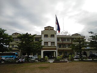
Dinalupihan, officially the Municipality of Dinalupihan, is a 1st class municipality in the province of Bataan, Philippines. According to the 2020 census, it has a population of 118,209 people.

Hermosa, officially the Municipality of Hermosa, is a 1st class municipality in the province of Bataan, Philippines. According to the 2020 census, it has a population of 77,443 people.

Morong, officially the Municipality of Morong, is a 3rd class municipality in the province of Bataan, Philippines. According to the 2020 census, it has a population of 35,394 people.

Orani, officially the Municipality of Orani, is a 1st class municipality in the province of Bataan, Philippines. According to the 2020 census, it has a population of 70,342 people.

The Subic Special Economic and Freeport Zone, often shortened as Subic Bay or Subic, is a special economic zone and freeport area covering portions of the city of Olongapo and the town of Subic in Zambales, and the towns of Hermosa and Morong in Bataan in the Philippines. The relatively developed and fenced area is called the Subic Bay Freeport Zone (SBFZ).

The Subic–Clark–Tarlac Expressway (SCTEX), signed as E1 and E4 of the Philippine expressway network, is a controlled-access toll expressway in the Central Luzon region of the Philippines. From its northern terminus in Tarlac City to its southern terminus at Tipo in Dinalupihan, Bataan, the SCTEX serves as one of the main expressways in Luzon. The expressway is also connected to the Central Luzon Link Expressway, North Luzon Expressway, Tarlac–Pangasinan–La Union Expressway, and the Subic Freeport Expressway. The SCTEX is the country's longest expressway at 93.77 kilometers (58.27 mi) until the completion of Toll Road 4 of South Luzon Expressway (SLEX). The Subic–Clark–Tarlac Expressway was constructed to provide a more efficient transport corridor between Subic Bay Freeport, Clark, and the Central Techno Park in Tarlac, foster development on the municipalities served, and connect major infrastructures such as the Subic Seaport and Clark International Airport.

Subic Bay is a bay on the west coast of the island of Luzon in the Philippines, about 100 kilometers (62 mi) northwest of Manila Bay. An extension of the South China Sea, its shores were formerly the site of a major United States Navy facility, U.S. Naval Base Subic Bay, now an industrial and commercial area known as the Subic Bay Freeport Zone under the Subic Bay Metropolitan Authority.

The Roman Superhighway or Bataan Provincial Highway, formerly known as the Bataan Provincial Expressway, is a 68-kilometer (42 mi), two- to four-lane major highway that connects the municipality of Dinalupihan to the municipality of Mariveles in Bataan, Philippines. The entire road forms part of National Route 301 (N301) of the Philippine highway network.

The Subic Freeport Expressway (SFEX), formerly referred to as the Subic–Tipo Road, Subic–Tipo Expressway and North Luzon Expressway Segment 7, is a 8.8-kilometer (5.5 mi) four-lane expressway that connects the Subic–Clark–Tarlac Expressway to the Subic Freeport Zone in the Philippines. Its alignment traverses the provinces of Bataan and Zambales.

Bataan National Park is a protected area of the Philippines located in the mountainous interior of Bataan province in the Central Luzon Region. Activities in the park include nature viewing, bird watching, and trekking to its several peaks and waterfalls.
Leonardo "Ding" Banzon Roman is a Filipino politician who was the governor of the province of Bataan. He served the province as its governor for seventeen years from 1986 to 2004, having won a total of four gubernatorial elections following his appointment as officer-in-charge of Bataan during the Presidency of Corazon Aquino.

The Magapit Protected Landscape is a protected area of forested limestone hills and grasslands in the Cagayan Valley of northern Luzon island in the Philippines. It covers an area of 3,403.62 hectares in northeastern Cagayan province straddling the municipalities of Lal-lo and Gattaran. The park was established as a game refuge and bird sanctuary on 15 August 1947 covering an initial area of 4,554 hectares declared through Administrative Order No. 10 by President Manuel Roxas. On 23 April 2000, the park was redesignated as a protected landscape area under the National Integrated Protected Areas System Act through Proclamation No. 285 signed by President Joseph Estrada. The park is a component of the Northeastern Cagayan Key Biodiversity Area and also contains the Lal-lo and Gattaran Shell Middens, a proposed World Heritage Site.
The Casecnan Protected Landscape is a protected area in the Casecnan River watershed of eastern Luzon in the Philippines. It has a total area of 88,846.80 hectares straddling the provinces of Nueva Vizcaya, Quirino and Aurora. The 57,930-hectare (143,100-acre) Casecnan River Watershed Forest Reserve was established in August 1987 by virtue of Executive Order No. 136 issued by President Corazon Aquino. In April 2000, the forest reserve was enlarged to 88,846.80 hectares and was reclassified as a protected landscape area through Proclamation No. 289. It is considered one of the last remaining substantial water sources for the region of Central Luzon.
The Bigbiga Protected Landscape is a protected landscape of forested hills, open grasslands and natural springs in Ilocos Sur in the northwestern part of the island of Luzon, Philippines. It is one of five protected landscape areas in the Ilocos Region under the Philippines' National Integrated Protected Areas System. The park has a total area of 135.71 hectares located entirely within the municipality of Narvacan. It was created in 1939 as the Bigbiga Spring Watershed Forest Reserve by virtue of Proclamation No. 431 signed by President Manuel Luis Quezon. In 2000, it was reclassified as a protected landscape by Proclamation No. 290.

The Pantabangan–Carranglan Watershed Forest Reserve is a conservation area located in the upper reaches of the Pampanga River in Nueva Ecija, Philippines, and borders the Sierra Madre and Caraballo Mountains in Aurora and Nueva Vizcaya. It encompasses 84,500 hectares of the drainage basin surrounding the Pantabangan Lake, an impoundment of the Pampanga River by the Pantabangan Dam. The multi-purpose dam is situated at the confluence of Pampanga River's two headwaters, namely the Pantabangan and Carranglan Rivers in the municipality of Pantabangan. It stretches above the dam site for 21 kilometres (13 mi) to where Carranglan River originates in the Caraballo on the north, and for 18 kilometres (11 mi) to where Pantabangan River originates in the Sierra Madre on the east. It is considered a critical watershed for the agricultural economy and hydroelectric power generation in the region of Central Luzon.

Jose Abad Santos Avenue (JASA), also known as the Olongapo–Gapan Road and the Gapan–San Fernando–Olongapo Road, is a two-to-thirteen-lane 118-kilometer (73 mi) major highway spanning the provinces of Bataan, Nueva Ecija, Pampanga, and Zambales in Central Luzon, Philippines. The highway is designated as National Route 3 (N3) of the Philippine highway network.
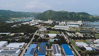
The Freeport Area of Bataan (FAB), formerly known as Mariveles Free Trade Zone from June 21, 1969 to November 20, 1972, and primarily as Bataan Export Processing Zone (BEPZ) and Bataan Economic Zone (BEZ) from November 20, 1972 to October 23, 2009 and secondarily from October 23, 2009 to June 30, 2010), is a special economic zone in Mariveles, Bataan, Philippines. It was envisioned by Congressman Pablo Roman, Sr., a representative from Bataan, who authored Republic Act 5490 designating the said location as the first free trade zone in the Philippines. It is also the second freeport zone in the province since October 23, 2009, after Subic Special Economic and Freeport Zone in Hermosa and Morong.

The Upper Agno River Basin Resource Reserve is a protected area located on the southeast flank of the Cordillera Central in the Philippine province of Benguet along its border with Ifugao and Nueva Vizcaya. It is a resource reserve located high in the Central and Polis ranges protecting the headwaters of the Agno River. According to section 4 of the National Integrated Protected Areas System Act, a resource reserve is an extensive and relatively isolated area designated as such to preserve the natural resources of the area. The reserve comprises 77,561 hectares of the catchment area that feeds the Ambuklao and Binga dams, two of the country's oldest hydroelectric plants that supply power to the city of Baguio and entire Benguet province. Upper Agno is north of and contiguous with the Lower Agno Watershed Forest Reserve that preserves the immediate downstream of the Binga Dam where the Agno River is impounded by a third dam, the San Roque Dam, the largest in the Philippines and the main source of water, electric energy and irrigation for surrounding regions in Luzon.


