Angat Watershed Forest Reserve

Last updated

Angat Watershed Forest Reserve
IUCN category VI (protected area with sustainable use of natural resources)
01510jfHilltop San Mateo Sitio Bitbit Lorenzo River Bridge Norzagaray Bulacan villagesfvf 05.JPG
View of the Angat reserve surrounding the Ipo Dam from the Hilltop view deck in Norzagaray
Philippines relief location map (square).svg
Red pog.svg
Location in the Philippines
Location Bulacan, Rizal, Nueva Ecija, Quezon, Philippines
Nearest city San Jose del Monte
Coordinates 14°58′18″N121°11′18″E / 14.97167°N 121.18833°E / 14.97167; 121.18833
Area62,309 hectares (153,970 acres)
EstablishedJuly 26, 1904 (reservation)
March 10, 1927 (forest reserve)
April 30, 1968 (pilot reserve/forest range)
Governing body Department of Environment and Natural Resources
Metropolitan Waterworks and Sewerage System
Angat Hydropower Corporation

The Angat Watershed Forest Reserve is a conservation area that protects the drainage basin in the southern Sierra Madre range north of Metro Manila in the Philippines where surface water empties into the Angat River and its distributaries. It is spread over an area of 62,309 hectares (153,970 acres) in the eastern portion of Bulacan and northern Rizal province at an altitude of between 490 and 1,206 metres (1,608 and 3,957 ft). [1] [2] The conservation area also extends to the provinces of Nueva Ecija and Quezon and is centered on an artificial lake created by the Angat Dam which, together with the Ipo Dam located 7.5 kilometres (4.7 mi) downstream, supply 97% of the water requirement of Metro Manila via an aqueduct system to the La Mesa Dam and Reservoir and the Balara Filtration Plant in Quezon City. [3] The Angat Dam and Reservoir is also a major source of hydroelectricity for Metro Manila and surrounding provinces, contributing some 200 megawatts to the Luzon grid. [4] The watershed is a popular birdwatching site and is a biodiversity hotspot containing most of the remaining closed-canopy forests in Central Luzon. [2]

Contents

History

The Angat Watershed was first gazetted on July 26, 1904, as the Angat River Reserve through Executive Order No. 33 signed by Civil Governor Luke Edward Wright. It set aside the Angat River in the municipality of Norzagaray bordering Mounts Salacot, Balugan and Sulip in the Sierra Madre range and including the Bulagao and Bitbit creeks for purposes of the development of water power from the river. [5] On March 10, 1927, through Proclamation No. 71 signed by Governor-General Leonard Wood, the 62,309-hectare (153,970-acre) Angat Watershed Forest Reserve was established covering portions of the municipalities of Montalban, San José del Monte, Norzagaray, Angat, San Rafael, San Miguel, Peñaranda and Infanta in the provinces of Rizal, Bulacan, Nueva Ecija and Tayabas, with the administration and control placed under the Department of Agriculture and Natural Resources. [6] At about this time, the Metropolitan Water District (now Metropolitan Waterworks and Sewerage System) started construction on the ₱11,500,000 Angat–Novaliches Water System including the Ipo Dam located within the reserve, which was completed in 1939 and inaugurated in 1940. [7] On December 4, 1965, with the construction of the Angat Hydroelectric Dam within the protected area, President Diosdado Macapagal signed Proclamation No. 505 transferring the administration of the whole reserve to the National Power Corporation. [8]

On April 30, 1968, 6,600 hectares (16,000 acres) of land surrounding the Ipo Dam was declared as a separate forest range and watershed management pilot project reserve through Proclamation No. 391 issued by President Ferdinand Marcos. This declaration effectively excluded the southern section of the watershed from the control of the National Power Corporation and placed it instead under the joint administration and control of the Director of Forestry of the Department of Agriculture and Natural Resources and the General Manager of the Metropolitan Waterworks and Sewerage System. [9]

Geography

Aerial view of the forest reserve Aerial view of Angat Watershed Forest Reserve.jpg
Aerial view of the forest reserve
Angat River in San Lorenzo, Norzagaray 01423jfHilltop San Mateo Sitio Bitbit Lorenzo River Bridge Norzagaray Bulacan villagesfvf 12.JPG
Angat River in San Lorenzo, Norzagaray

The Angat Watershed Forest Reserve is located approximately 35 kilometres (22 mi) northeast of Metro Manila largely in the mountainous eastern region of Bulacan. It contains the headwaters of the Angat River, a tributary of the Rio Grande de Pampanga, and stretches along upper Angat River from San Jose del Monte and Rodriguez to Doña Remedios Trinidad, and extending to General Tinio and General Nakar. [3] The forest reserve is divided into two sub-catchment areas: the Forest Range and the Metro Water District. [10] [11] The Angat Watershed and Forest Range, also known as the Angat Watershed Management Pilot Project Reserve, covers 6,600 hectares (16,000 acres) in San Jose del Monte, Norzagaray and Rodriguez, and supports the Ipo Dam, which has a capacity of 7,500,000 cubic metres (260,000,000 cu ft) and a spilling level of 101 metres (331 ft). It is under the administration of the Department of Environment and Natural Resources and Metropolitan Waterworks and Sewerage System. The Metro Water District, also known as the Angat–Maasim River Watershed, covers the remaining 55,709 hectares (137,660 acres) and contains the Angat Hydroelectric Dam, which has a reservoir capacity of 850,000,000 cubic metres (3.0×10¹⁰ cu ft) and a normal water level of 212 metres (696 ft). [3] The Angat Hydropower Corporation, a joint venture of San Miguel Corporation and K-water, has managed the reserve since taking over ownership of the hydroelectric power plant from the National Power Corporation in 2014. [3] [12]

The southern Sierra Madre range in Bulacan 01316jfHilltop San Mateo Sitio Bitbit Lorenzo River Bridge Norzagaray Bulacan villagesfvf 14.JPG
The southern Sierra Madre range in Bulacan
View of the Angat River from a boat Angat Watershed Forest Reserve in Norzagaray, Bulacan.jpg
View of the Angat River from a boat

The watershed is characterized by hilly to mountainous topography and a moderate to intensive forest cover. It is considered as one of the few remaining well-forested and well-managed watersheds in the country. [13] The highest peak in Bulacan, Mount Oriod, rises to a height of 1,206 metres (3,957 ft) at the border of the two sub-catchment areas in Norzagaray. [14] It also contains Mount Maranat, a popular destination for hikers and is also visited for its waterfalls. [15] These mountains in the southern Sierra Madre range feed the Angat River's water source from its three major tributaries: the Talaguio, Catmon and Matulid Rivers. It stretches downstream from the watershed into several municipalities and irrigates more than 30,000 hectares (74,000 acres) of prime agricultural lands before draining into the Pampanga River in Calumpit and eventually exiting into Manila Bay. [4] [13] Additional water supply is fed into the Angat reservoir through the Angat–Umiray trans-basin tunnel which runs for 13 kilometres (8.1 mi) from Umiray River on the eastern side of Sierra Madre in General Nakar. [13]

The reserve is home to an indigenous population known as Dumagat tribe which inhabit twelve sitios in the villages of San Mateo, San Lorenzo and San Isidro in Norzagaray, and Kabayunan in Doña Remedios Trinidad. [1] In December 2014, the National Power Corporation inaugurated the Angat Rainforest and Ecological Park within the reserve in Sitio Bitbit, San Lorenzo, Norzagaray. [16] It offers many different opportunities for nature and outdoors enthusiasts including the hilltop view deck, ecological center, and the Tarictic fun trail. A museum of natural history is also planned for the park, as well as a Dumagat cultural heritage site, seedling propagation, rattan gene bank and a bambusetum. [16]

The Upper Marikina River Basin Protected Landscape borders Angat Watershed on the south, while on the north, it is also contiguous with the 20,760-hectare (51,300-acre) Doña Remedios–General Tinio Watershed Forest Reserve. It is also bordered by the Biak-na-Bato National Park and Minalungao National Park on the west and northwest. [11] It is accessible from Manila via Quirino Highway, Del Monte–Norzagaray Road and Bigte–San Mateo Road (Ipo Road) in Norzagaray.

Angat Watershed welcome sign in Brgy. San Mateo, Nozagaray, Bulacan 09418jfBridge Poblacion Bigte San Mateo Lorenzo Hilltop Norzagaray Bulacanfvf 04.JPG
Angat Watershed welcome sign in Brgy. San Mateo, Nozagaray, Bulacan

Biodiversity

The Angat Watershed supports a variety of wildlife thanks to its location in the Sierra Madre and its rich hydrology and terrestrial ecology coated by lowland dipterocarp forests, submontane forests, grasslands, secondary bamboo and scrublands. [1] [2] It is home to 290 endemic species of woody and non-woody plants, including the white lauan (known locally as bagtikan), tanguile, yakal, acacia and narra. [16] [1] A good area for bird-watching, the Angat reserve attracts 43 different bird species, many of which are threatened or restricted. In addition to the two most visible birds in the reserve, the Luzon hornbill (known locally as kalao) and the Rufous hornbill, the reserve also attracts large flocks of spotted imperial pigeon, scale-feathered malkoha, rough-crested malkoha, grey-backed tailorbird, and Philippine eagle owl. [16] These avian species are all endemic to the Philippines, with the Luzon hornbill and Philippine eagle-owl classified as near-threatened and vulnerable. [1] The data-deficient Worcester's buttonquail has also been recorded in the watershed, as well as the Philippine hawk-eagle, Philippine dwarf kingfisher, green racket-tail, whiskered pitta, celestial monarch, ashy thrush, ashy-breasted flycatcher, flame-breasted fruit dove, and green-faced parrotfinch. [2]

Two near-threatened mammals are known to roam the watershed forest at Angat, the crab-eating macaque and the Philippine warty pig. [3] It is also a known habitat of the Philippine deer. [2] Other rare species of note in the protected area include the blazed Luzon shrew rat, and 66 species of vertebrates, including the endemic Japanese bullet frog and marbled water monitor. [1] The Angat reservoir is stocked with huge tilapia and eel. [16]

Related Research Articles

<span class="mw-page-title-main">Bulacan</span> Province in Central Luzon, Philippines

Bulacan, officially the Province of Bulacan, is a province in the Philippines located in the Central Luzon region. Its capital is the city of Malolos. Bulacan was established on August 15, 1578, and part of the Metro Luzon Urban Beltway Super Region.

<span class="mw-page-title-main">San Jose del Monte</span> Component city in Bulacan, Philippines

San Jose del Monte, officially the City of San Jose del Monte, is a 1st class component city in the province of Bulacan, Philippines. According to the 2020 census, it has a population of 651,813 people, making it the largest local government unit within the province of Bulacan and Central Luzon, and the 18th most populated city in the Philippines.

<span class="mw-page-title-main">Pampanga River</span> River on the island of Luzon, the Philippines

The Pampanga River is the second largest river on the island of Luzon in the Philippines and the country's fifth longest river. It is in the Central Luzon region and traverses the provinces of Pampanga, Bulacan, and Nueva Ecija.

<span class="mw-page-title-main">Angat, Bulacan</span> Municipality in Bulacan, Philippines

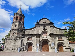
Angat, officially the Municipality of Angat, is a 1st class municipality in the province of Bulacan, Philippines. According to the 2020 census, it has a population of 65,617 people.

<span class="mw-page-title-main">Doña Remedios Trinidad</span> Municipality in Bulacan, Philippines

Doña Remedios Trinidad, officially the Municipality of Doña Remedios Trinidad, is a 1st class municipality in the province of Bulacan, Philippines. According to the 2020 census, it has a population of 28,656 people.

<span class="mw-page-title-main">Norzagaray</span> Municipality in Bulacan, Philippines

Norzagaray, officially the Municipality of Norzagaray, is a 1st class municipality in the province of Bulacan, Philippines. According to the 2020 census, it has a population of 136,064 people.

<span class="mw-page-title-main">Angat River</span> River in Central Luzon, Philippines

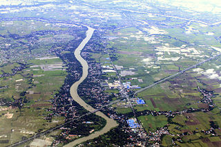
The Angat River is a river in the Philippines located in the province of Bulacan. It flows from the Sierra Madre mountain range to Manila Bay. Three dams are located along the river namely Angat, Ipo and Bustos. The catchment or basin area of the river is 1,085 square kilometres (419 sq mi) located in the Angat Watershed Forest Reserve. Angat River snakes through the municipalities of Doña Remedios Trinidad, Norzagaray, Angat, Bustos, San Rafael, Baliwag, Plaridel, Pulilan, Calumpit, Paombong, and Hagonoy. The river joins the Pampanga River at Calumpit via the Bagbag River.

<span class="mw-page-title-main">Manila Water</span>

Manila Water Company, Inc. has the exclusive right to provide water and used water (wastewater) services to over six million people in the East Zone of Metro Manila. It is a subsidiary of the country's oldest conglomerate, Ayala Corporation.

<span class="mw-page-title-main">La Mesa Dam and Reservoir</span> Dam in Quezon City, Philippines

The La Mesa Dam and Reservoir is an earth dam in Quezon City, Philippines. Its reservoir can hold up to 50.5 million cubic meters, occupying an area of 27 square kilometers (10 sq mi). It is part of the Angat-Ipo-La Mesa water system, which supplies most of the water supply of Metro Manila.

<span class="mw-page-title-main">North Luzon East Expressway</span> Road in the Philippines

The North Luzon East Expressway (NLEE) is an under-construction four-lane, 92.1-kilometre (57.2 mi) long limited-access toll expressway in the Central Luzon region of the Philippines.

<span class="mw-page-title-main">Angat Dam</span> Dam in Bulacan, Philippines

Angat Dam is a concrete water reservoir embankment hydroelectric dam that supplies Metro Manila and nearby provinces with water. It was a part of the Angat-Ipo-La Mesa water system. The reservoir supplies about 90 percent of raw water requirements for Metro Manila through the facilities of the Metropolitan Waterworks and Sewerage System and it irrigates about 28,000 hectares of farmland in the provinces of Bulacan and Pampanga.

<span class="mw-page-title-main">Ipo Dam</span> Dam in Bulacan, Philippines

Ipo Dam is a concrete water reservoir gravity dam found in the Philippines. The dam is located about 7.5 kilometres downstream of the Angat Dam within the Angat Watershed Forest Reserve in Norzagaray, Bulacan province. It was a part of the Angat-Ipo-La Mesa water system. Its normal level is 101 m.

Several bulk water supply projects on the upper portion of the Kaliwa River Watershed have been proposed by the Philippine Government since the 1970s, with the intent of relieving Metro Manila of its overdependence on the water supplied by Angat Dam. Most of these have focused on a particular site in Barangay Laiban in Tanay, Rizal, on the upper portion of the Kaliwa River Watershed to which the Laiban Dam belongs, and the projects have thus often been referred to as Laiban dam or Kaliwa dam, although multiple projects have been referred to using either name.

<span class="mw-page-title-main">La Mesa Watershed Reservation</span> Protected area in Metro Manila, Philippines

The La Mesa Watershed Reservation is a protected area that preserves the only major watershed in Metro Manila, Philippines. Also known as the Novaliches Watershed, it contains the last remaining rainforest of its size in Metro Manila surrounding the La Mesa Dam and Reservoir, the primary source of potable drinking water for 12 million residents in the Manila metropolitan area. The area is under the joint administration, supervision and control of the Department of Environment and Natural Resources and the Metropolitan Waterworks and Sewerage System. It was established in 2007 through Proclamation No. 1336 issued by President Gloria Arroyo.

The Amro River Protected Landscape is a protected landscape area located in the province of Aurora in eastern Central Luzon in the Philippines. It preserves the primary water source for agricultural, power generation and domestic consumption of the remote northern Auroran communities on the Pacific coast. The area was first established in 1990 as the Amro River Watershed Forest Reserve to protect, maintain and improve the water yield of the Amro River as declared through Proclamation No. 633 by President Corazón Aquino. In 2000, the forest reserve was reclassified as a protected landscape under the National Integrated Protected Areas System with the enactment of Proclamation No. 274 by President Joseph Estrada. It is one of five declared protected areas of the Philippines in Aurora.

<span class="mw-page-title-main">Sierra Madre (Philippines)</span> Mountain range in the Philippines

The Sierra Madre is the longest mountain range in the Philippines. Spanning over 540 kilometers (340 mi), it runs from the province of Cagayan down to the province of Quezon, forming a north–south direction on the eastern portion of Luzon, the largest island of the archipelago. It is bordered by the Pacific Ocean to the east, Cagayan Valley to the northwest, Central Luzon to the midwest, and Calabarzon to the southwest. Some communities east of the mountain range, along the coast, are less developed and so remote that they could only be accessed by taking a plane or a boat.

<span class="mw-page-title-main">Pantabangan–Carranglan Watershed Forest Reserve</span> Nature reserve in the Philippines

The Pantabangan–Carranglan Watershed Forest Reserve is a conservation area located in the upper reaches of the Pampanga River in Nueva Ecija, Philippines, and borders the Sierra Madre and Caraballo Mountains in Aurora and Nueva Vizcaya. It encompasses 84,500 hectares of the drainage basin surrounding the Pantabangan Lake, an impoundment of the Pampanga River by the Pantabangan Dam. The multi-purpose dam is situated at the confluence of Pampanga River's two headwaters, namely the Pantabangan and Carranglan Rivers in the municipality of Pantabangan. It stretches above the dam site for 21 kilometres (13 mi) to where Carranglan River originates in the Caraballo on the north, and for 18 kilometres (11 mi) to where Pantabangan River originates in the Sierra Madre on the east. It is considered a critical watershed for the agricultural economy and hydroelectric power generation in the region of Central Luzon.

<span class="mw-page-title-main">Pamitinan Protected Landscape</span> Protected area in Philippines

The Pamitinan Protected Landscape is a Philippine protected area of approximately 608 hectares in the Sierra Madre mountain range, just 34 kilometres (21 mi) northeast of Manila. It contains and protects the Montalban Gorge formed by the Marikina River that separates Mount Pamitinan and Mount Binacayan in the municipality of Rodriguez in Rizal. Established in 1996 through Proclamation No. 901 issued by President Fidel Ramos, the park is originally a component of the Mariquina Reserve founded in 1904 to protect the watershed of the Marikina River that supplied water to the city of Manila from the Wawa Dam located just above the Montalban Gorge in the early 1900s.

<span class="mw-page-title-main">Upper Agno River Basin Resource Reserve</span>

The Upper Agno River Basin Resource Reserve is a protected area located on the southeast flank of the Cordillera Central in the Philippine province of Benguet along its border with Ifugao and Nueva Vizcaya. It is a resource reserve located high in the Central and Polis ranges protecting the headwaters of the Agno River. According to section 4 of the National Integrated Protected Areas System Act, a resource reserve is an extensive and relatively isolated area designated as such to preserve the natural resources of the area. The reserve comprises 77,561 hectares of the catchment area that feeds the Ambuklao and Binga dams, two of the country's oldest hydroelectric plants that supply power to the city of Baguio and entire Benguet province. Upper Agno is north of and contiguous with the Lower Agno Watershed Forest Reserve that preserves the immediate downstream of the Binga Dam where the Agno River is impounded by a third dam, the San Roque Dam, the largest in the Philippines and the main source of water, electric energy and irrigation for surrounding regions in Luzon.

<span class="mw-page-title-main">Lower Agno Watershed Forest Reserve</span>

The Lower Agno Watershed Forest Reserve is a Philippine protected area that straddles the Cordillera and Ilocos regions encompassing land from the provinces of Benguet and Pangasinan. Operated by the Lower Agno WFR Protected Area Management Board under the Department of Environment and Natural Resources, Lower Agno follows the Agno River corridor from the northern villages of Itogon to just north of the municipalities of San Manuel and San Nicolas. The reserve also known as the San Roque Watershed protects the mid-Agno River basin with its meandering river and short tributaries in a pine-forested mountainous terrain at the southern end of the Cordillera Central, around 30 kilometres (19 mi) southeast of Baguio. It is located in an important mining district and includes the reservoir of the San Roque Dam, the largest dam in the country and the prime source of water, hydropower and irrigation for surrounding regions in Luzon.

References

  1. 1 2 3 4 5 6 "Philippines: Angat Water Transmission Improvement Project" (PDF). Asian Development Bank. July 2014. Retrieved February 6, 2017.
  2. 1 2 3 4 5 "Angat Watershed Forest Reserve". BirdLife International . Retrieved February 6, 2017.
  3. 1 2 3 4 5 Lopez, M.A.G. (November 10, 2015). "Save Angat, save Metro Manila". BusinessWorld . Retrieved February 6, 2017.
  4. 1 2 "Angat Watershed". Department of Environment and Natural Resources Region 3. Retrieved February 6, 2017.
  5. "Executive orders and proclamations issued by the governor-general. (1904)". University of Michigan Library . Retrieved February 13, 2017.
  6. "Proclamation No. 71". Abernales. Retrieved February 6, 2017.
  7. Philippines Bureau of Health (1950). Monthly Bulletin of the Philippine Health Service Vol. 26. Bureau of Printing. Retrieved February 6, 2017.
  8. "Proclamation No. 505, s. 1965". Official Gazette (Philippines) . Retrieved February 6, 2017.
  9. "Proclamation No. 391, s. 1968". Official Gazette (Philippines) . Retrieved February 6, 2017.
  10. "Angat". Protected Planet . Retrieved February 6, 2017.
  11. 1 2 "Angat (Metro Water District)". Protected Planet . Retrieved February 6, 2017.
  12. Olchondra, R.T. (September 3, 2013). "K-Water secures Angat hydro plant with San Miguel group". Philippine Daily Inquirer . Retrieved February 6, 2017.
  13. 1 2 3 Faustino–Eslava, D.V. (January 15, 2013). "A FORIN Template for Tackling Issues Related to the Valley Fault System and the Angat Dam in Luzon, Philippines" (PDF). Integrated Research on Disaster Risk International. Retrieved February 6, 2017.
  14. "Mount Oriod". Peakery. Archived from the original on February 7, 2017. Retrieved February 6, 2017.
  15. Lasco, G. (November 26, 2015). "Mountain News: DENR to require permits for Maranat". Pinoymountaineer.com. Retrieved February 6, 2017.
  16. 1 2 3 4 5 "Angat rainforest park spotlights biodiversity hotspot". Rappler. December 20, 2014. Retrieved February 6, 2017.