The Cagayan River, also known as the Río Grande de Cagayán, is the longest river and the largest river by discharge volume of water in the Philippines. It has a total length of approximately 505 kilometres (314 mi) and a drainage basin covering 27,753 square kilometres (10,715 sq mi). It is located in the Cagayan Valley region in northeastern part of Luzon Island and traverses the provinces of Nueva Vizcaya, Quirino, Isabela and Cagayan.

Cagayan Valley, designated as Region II, is an administrative region in the Philippines. Located in the northeastern section of Luzon, it is composed of five Philippine provinces: Batanes, Cagayan, Isabela, Nueva Vizcaya, and Quirino. The region hosts four chartered cities: Cauayan, Ilagan, Santiago, and Tuguegarao.

Isabela, officially the Province of Isabela, is the second largest province in the Philippines in land area located in the Cagayan Valley. Its capital and the largest local government unit is the city of Ilagan. It is bordered by the provinces of Cagayan to the north, Kalinga to the northwest, Mountain Province to the central-west, Ifugao and Nueva Vizcaya to the southwest, Quirino, Aurora and the independent city of Santiago to the south, and the Philippine Sea to the east.

Ilagan, officially the City of Ilagan, is a component city and capital of the province of Isabela, Philippines. According to the 2020 census, it has a population of 158,218 people making it the most populous city in the province and the second most-populous in Cagayan Valley after Tuguegarao. As of 2022, it also had the most number of voters in the province with 101,050 electorates.

Palanan, officially the Municipality of Palanan, is a municipality in the province of Isabela, Philippines. It also served as the final capital of the First Philippine Republic from 1900 until the capture of President Emilio Aguinaldo by the Americans during the Philippine-American War in 1901. According to the 2020 census, it has a population of 17,684 people.

Divilacan, officially the Municipality of Divilacan, is a municipality in the province of Isabela, Philippines. According to the 2020 census, it has a population of 5,827 people.

Maconacon, officially the Municipality of Maconacon, is a municipality in the province of Isabela, Philippines. According to the 2020 census, it has a population of 3,977 people, making it the least populous municipality in the province.
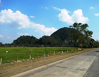
San Mariano, officially the Municipality of San Mariano; Ilocano: Ili ti San Mariano; Tagalog: Bayan ng San Mariano), is a municipality in the province of Isabela, Philippines. According to the 2020 census, it has a population of 60,124 people.
The legislative districts of Isabela are the representations of the province of Isabela and the independent component city of Santiago in the various national legislatures of the Philippines. The province and the city are currently represented in the lower house of the Congress of the Philippines through their first, second, third, fourth, fifth, and sixth congressional districts.
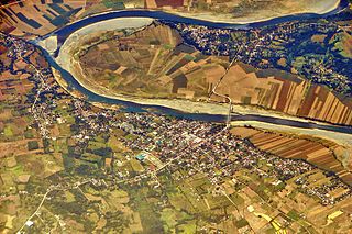
The Ilagan River, also known as the Pinacanauan de Ilagan River, is a river in the province of Isabela, Cagayan Valley, Philippines. It is one of the major tributaries of the Cagayan River, the largest river in the Philippines. The Ilagan River originates from the western slopes of the Sierra Madre and drains the eastern central portion of the Cagayan River basin. It has an estimated catchment basin size of 3,132 square kilometres (1,209 sq mi) and an estimated annual discharge of 9,455 million cubic meters/s. It flows westward and joins the Cagayan River at Ilagan, Isabela.
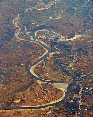
The Pinacanauan River, also known as the Pinacanauan de Tuguegarao, is a tributary of the Cagayan River located in the province in Cagayan, in the northern portion of Luzon in the Philippines. With a length of 46 kilometres (29 mi), the river originates in the Sierra Madre and passes through the Peñablanca Protected Landscape and Seascape, with large karst formations, underground chambers, and rare wild flora, before entering the Cagayan River in Tuguegarao, Cagayan. The Pinacanauan is considered one of the most picturesque attractions in Cagayan, passing beside the Callao Cave system.

Balbalasang–Balbalan National Park is a protected area of the Philippines located in the municipality of Balbalan, Kalinga in the Cordillera Administrative Region.

The Peñablanca Protected Landscape and Seascape is a protected area and national park in Peñablanca, Cagayan. It is on the border with Isabela province, contiguous with the Northern Sierra Madre Natural Park. The protected area, best known as the location of Callao Cave, covers the largest block of forest under conservation in the province. It covers 118,781.582 hectares of the northern Sierra Madre mountain range and its adjacent Pacific coast.

The Magapit Protected Landscape is a protected area of forested limestone hills and grasslands in the Cagayan Valley of northern Luzon island in the Philippines. It covers an area of 3,403.62 hectares in northeastern Cagayan province straddling the municipalities of Lal-lo and Gattaran. The park was established as a game refuge and bird sanctuary on 15 August 1947 covering an initial area of 4,554 hectares declared through Administrative Order No. 10 by President Manuel Roxas. On 23 April 2000, the park was redesignated as a protected landscape area under the National Integrated Protected Areas System Act through Proclamation No. 285 signed by President Joseph Estrada. The park is a component of the Northeastern Cagayan Key Biodiversity Area and also contains the Lal-lo and Gattaran Shell Middens, a proposed World Heritage Site.
The Casecnan Protected Landscape is a protected area in the Casecnan River watershed of eastern Luzon in the Philippines. It has a total area of 88,846.80 hectares straddling the provinces of Nueva Vizcaya, Quirino and Aurora. The 57,930-hectare (143,100-acre) Casecnan River Watershed Forest Reserve was established in August 1987 by virtue of Executive Order No. 136 issued by President Corazon Aquino. In April 2000, the forest reserve was enlarged to 88,846.80 hectares and was reclassified as a protected landscape area through Proclamation No. 289. It is considered one of the last remaining substantial water sources for the region of Central Luzon.
The Amro River Protected Landscape is a protected landscape area located in the province of Aurora in eastern Central Luzon in the Philippines. It preserves the primary water source for agricultural, power generation and domestic consumption of the remote northern Auroran communities on the Pacific coast. The area was first established in 1990 as the Amro River Watershed Forest Reserve to protect, maintain and improve the water yield of the Amro River as declared through Proclamation No. 633 by President Corazón Aquino. In 2000, the forest reserve was reclassified as a protected landscape under the National Integrated Protected Areas System with the enactment of Proclamation No. 274 by President Joseph Estrada. It is one of five declared protected areas of the Philippines in Aurora.

The Sierra Madre is the longest mountain range in the Philippines. Spanning over 540 kilometers (340 mi), it runs from the province of Cagayan down to the province of Quezon in a north–south direction on the eastern portion of Luzon, the largest island of the archipelago. It is bordered by the Pacific Ocean to the east, Cagayan Valley to the northwest, Central Luzon to the midwest, and Calabarzon to the southwest. Some communities east of the mountain range, along the coast, are less developed and so remote that they could only be accessed by taking a plane or a boat.
The Quirino Protected Landscape is a protected area in the Philippine island of Luzon that covers a large portion of the province of Quirino. It was established in 2004 to preserve the watershed area containing the headwaters of the Cagayan River, also known as the Rio Grande de Cagayan, which supports major irrigation systems in the entire Cagayan Valley region. From an initial area of 206,875.41 hectares, the protected area now forms a total aggregate area of 175,943.62 hectares divided into three parcels after a 2005 amendment opened up a few areas to mining. It is a key biodiversity area of the Sierra Madre Biodiversity Corridor.

The Angat Watershed Forest Reserve is a conservation area that protects the drainage basin in the southern Sierra Madre range north of Metro Manila in the Philippines where surface water empties into the Angat River and its distributaries. It is spread over an area of 62,309 hectares in the eastern portion of Bulacan and northern Rizal province at an altitude of between 490 and 1,206 metres. The conservation area also extends to the provinces of Nueva Ecija and Quezon and is centered on an artificial lake created by the Angat Dam which, together with the Ipo Dam located 7.5 kilometres (4.7 mi) downstream, supply 97% of the water requirement of Metro Manila via an aqueduct system to the La Mesa Dam and Reservoir and the Balara Filtration Plant in Quezon City. The Angat Dam and Reservoir is also a major source of hydroelectricity for Metro Manila and surrounding provinces, contributing some 200 megawatts to the Luzon grid. The watershed is a popular birdwatching site and is a biodiversity hotspot containing most of the remaining closed-canopy forests in Central Luzon.
The Ilagan–Divilacan Road is one of the infrastructural components being considered for building that would connect the city of Ilagan with the coastal town of Divilacan, both located in the province of Isabela. The road stretches approximately 82 kilometers through the Sierra Madre mountain range, giving better access to the remote towns in the province of Isabela, eastern coast. The road will be important for enhancing transportation and economic opportunities in the area and with regard to the access of goods and services to otherwise isolated areas.


