Dinapigue

Last updated
Dinapigue
Municipality of Dinapigue
View of the forested west coast of Isabela Province (Dinapique) - ZooKeys-266-001-g003.jpg
View of the forested coast of Dinapigue
Flag of Dinapigue, Isabela.png
Dinapigue Isabela.png
Ph locator isabela dinapigue.png
Map of Isabela with Dinapigue highlighted
OpenStreetMap
Dinapigue
Philippines location map (square).svg
Red pog.svg
Dinapigue
Location within the Philippines
Coordinates: 16°31′30″N122°15′49″E / 16.525°N 122.2636°E / 16.525; 122.2636
Country Philippines
Region Cagayan Valley
Province Isabela
District 4th district
Founded 1969
Barangays 6 (see Barangays)
Government
[1]
  Type Sangguniang Bayan
   Mayor Vicente D. Mendoza
   Vice Mayor Reynaldo D. Derije
   Representative Joseph S. Tan
   Electorate 4,508 voters (2022)
Area
[2]
  Total574.40 km2 (221.78 sq mi)
Elevation
124 m (407 ft)
Highest elevation
745 m (2,444 ft)
Lowest elevation
0 m (0 ft)
Population
 (2020 census) [3]
  Total5,821
  Density10/km2 (26/sq mi)
   Households
1,405
Economy
   Income class 1st municipal income class
   Poverty incidence
44.81
% (2018) [4]
   Revenue 209.1 million (2020)
   Assets 359.5 million (2020)
   Expenditure 169 million (2020)
   Liabilities 45.85 million (2020)
Service provider
  ElectricityAurora Electric Cooperative (AURELCO)
Time zone UTC+8 (PST)
ZIP code
3336
PSGC
IDD : area code +63(0)78
Native languages Dinapigue Agta
Ibanag
Ilocano
Kasiguranin
Tagalog
Website www.dinapigue-isabela.gov.ph

Dinapigue, officially the Municipality of Dinapigue (Ibanag : Ili nat Dinapigue; Ilocano : Ili ti Dinapigue; Tagalog/Kasiguranin: Bayan ng Dinapigue), is a 1st class municipality in the province of Isabela, Philippines. According to the 2020 census, it has a population of 5,821 people. [3]

Contents

History

Dinapigue was founded as a barrio of San Mariano, Isabela. In June 21, 1969, Republic Act No. 5776 declared Dinapigue was declared as a separate municipality, independent from San Mariano. [5]

Geography

Dinapigue or sometimes called Dinapigui is the southernmost coastal town of the province of Isabela. It is one of the four remote and isolated coastal towns facing the Philippine Sea on the east and separated from the rest of the province by the Sierra Madre Mountains.

It is bounded by the coastal town of Palanan to the north, San Mariano to the northwest, San Guillermo to the west, Echague to the southwest, Dilasag in the province of Aurora to the south and the Philippine Sea to the east.

Barangays

Dinapigue is politically subdivided into 6 barangays. [6] Each barangay consists of puroks while some have sitios.

Climate

Climate data for Dinapigue, Isabela
MonthJanFebMarAprMayJunJulAugSepOctNovDecYear
Mean daily maximum °C (°F)27
(81)
27
(81)
29
(84)
28
(82)
27
(81)
25
(77)
26
(79)
27
(81)
31
(88)
29
(84)
27
(81)
27
(81)
28
(82)
Mean daily minimum °C (°F)20
(68)
20
(68)
21
(70)
20
(68)
21
(70)
20
(68)
21
(70)
22
(72)
23
(73)
23
(73)
21
(70)
21
(70)
21
(70)
Average precipitation mm (inches)162
(6.4)
156
(6.1)
90
(3.5)
60
(2.4)
144
(5.7)
201
(7.9)
159
(6.3)
108
(4.3)
111
(4.4)
237
(9.3)
276
(10.9)
171
(6.7)
1,875
(73.9)
Average rainy days141211111619161416181815180
Source: World Weather Online (modeled/calculated data, not measured locally) [7]

Demographics

Population census of Dinapigue
YearPop.±% p.a.
1975 932    
1980 764−3.90%
1990 2,105+10.67%
1995 3,046+7.17%
2000 3,171+0.87%
2007 4,807+5.91%
2010 5,484+4.91%
2015 5,005−1.73%
2020 5,821+3.01%
Source: Philippine Statistics Authority [8] [9] [10] [11]

In the 2020 census, the population of Dinapigue was 5,821 people, [3] with a density of 10 inhabitants per square kilometre or 26 inhabitants per square mile.

Economy

Government

Local government

As a municipality in the Province of Isabela, government officials in the provincial level are voted by the electorates of the town. The provincial government have political jurisdiction over local transactions of the municipal government.

The municipality of Dinapigue is governed by a mayor designated as its local chief executive and by a municipal council as its legislative body in accordance with the Local Government Code. The mayor, vice mayor, and the councilors are elected directly by the people through an election which is being held every three years.

Barangays are also headed by elected officials: Barangay Captain, Barangay Council, whose members are called Barangay Councilors. The barangays have SK federation which represents the barangay, headed by SK chairperson and whose members are called SK councilors. All officials are also elected every three years.

Elected officials

Members of the Municipal Council
(2022-2025) [19]
PositionName
CongressmanJoseph S. Tan
MayorVicente D. Mendoza
Vice-MayorReynaldo D. Derije
CouncilorsSamuel P. Cariño
Benito J. Monzon
Joel B. Araña
Aldo Rey T. Vargas
Jhonas

D. Palitayan

Jojit Alexis G. Arana
Shelah M. Candido
Joselito D. Derije

Congress representation

Dinapique, belonging to the fourth legislative district of the province of Isabela, currently represented by Hon. Joseph S. Tan. [20] [21]

Education

The Schools Division of Isabela governs the town's public education system. [22] The division office is a field office of the DepEd in Cagayan Valley region. [23] The office governs the public and private elementary and public and private high schools throughout the municipality.

Infrastructure

Dinapigue is accessible by land but it can also be accessed by air through Dinapigue Airport. Small time bus companies offer daily trips from Santiago City to Dinapigue via Quirino province through the towns of Dinalungan, Casiguran, and Dilasag in the province Aurora.

Related Research Articles

<span class="mw-page-title-main">Palanan</span> Municipality in Isabela, Philippines

Palanan, officially the Municipality of Palanan, is a 1st class municipality in the province of Isabela, Philippines. It also served as the final capital of the First Philippine Republic from 1900 until the capture of President Emilio Aguinaldo by the Americans during the Philippine-American War in 1901. According to the 2020 census, it has a population of 17,684 people.

<span class="mw-page-title-main">Angadanan</span> Municipality in Isabela, Philippines

Angadanan, officially the Municipality of Angadanan, is a 3rd class municipality in the province of Isabela, Philippines. At the 2020 census, it had a population of 44,977.

<span class="mw-page-title-main">Aurora, Isabela</span> Municipality in Isabela, Philippines

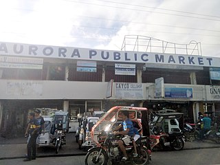
Aurora, officially the Municipality of Aurora, is a 3rd class municipality in the province of Isabela, Philippines. According to the 2020 census, it has a population of 36,621 people.

<span class="mw-page-title-main">Benito Soliven</span> Municipality in Isabela, Philippines

Benito Soliven, officially the Municipality of Benito Soliven, is a 4th class municipality in the province of Isabela, Philippines. According to the 2020 census, it has a population of 29,752 people.

<span class="mw-page-title-main">Burgos, Isabela</span> Municipality in Isabela, Philippines

Burgos, officially the Municipality of Burgos, is a 4th class municipality in the province of Isabela, Philippines. According to the 2020 census, it has a population of 26,040 people.

<span class="mw-page-title-main">Cordon, Isabela</span> Municipality in Isabela, Philippines

Cordon, officially the Municipality of Cordon, is a 2nd class municipality in the province of Isabela, Philippines. According to the 2020 census, it has a population of 46,477 people.

<span class="mw-page-title-main">Divilacan</span> Municipality in Isabela, Philippines

Divilacan, officially the Municipality of Divilacan, is a 2nd class municipality in the province of Isabela, Philippines. According to the 2020 census, it has a population of 5,827 people.

<span class="mw-page-title-main">Echague</span> Municipality in Isabela, Philippines

Echague, officially the Municipality of Echague, is a 1st class municipality in the province of Isabela, Philippines. According to the 2020 census, it has a population of 88,410 people. The town is known for the indigenous and endangered Yogad language, which is spoken and conserved by its locals.

<span class="mw-page-title-main">Luna, Isabela</span> Municipality in Isabela, Philippines

Luna, officially the Municipality of Luna, is a 5th class municipality in the province of Isabela, Philippines. According to the 2020 census, it has a population of 20,697 people.

<span class="mw-page-title-main">Maconacon</span> Municipality in Isabela, Philippines

Maconacon, officially the Municipality of Maconacon, is a 3rd class municipality in the province of Isabela, Philippines. According to the 2020 census, it has a population of 3,977 people, making it the least populous municipality in the province.

<span class="mw-page-title-main">Naguilian, Isabela</span> Municipality in Isabela, Philippines

Naguilian, officially the Municipality of Naguilian, is a 4th class municipality in the province of Isabela, Philippines. According to the 2020 census, it has a population of 33,788 people.

<span class="mw-page-title-main">Quirino, Isabela</span> Municipality in Isabela, Philippines

Quirino, officially the Municipality of Quirino, is a 4th class municipality in the province of Isabela, Philippines. According to the 2020 census, it has a population of 25,023 people.

<span class="mw-page-title-main">Reina Mercedes, Isabela</span> Municipality in Isabela, Philippines

Reina Mercedes, officially the Municipality of Reina Mercedes, is a 4th class municipality in the province of Isabela, Philippines. According to the 2020 census, it has a population of 27,900 people.

<span class="mw-page-title-main">San Agustin, Isabela</span> Municipality in Isabela, Philippines

San Agustin, officially the Municipality of San Agustin, is a 3rd class municipality in the province of Isabela, Philippines. According to the 2020 census, it has a population of 22,096 people.

<span class="mw-page-title-main">San Guillermo</span> Municipality in Isabela, Philippines

San Guillermo, officially the Municipality of San Guillermo, is a 4th class municipality in the province of Isabela, Philippines. According to the 2020 census, it has a population of 20,915 people.

<span class="mw-page-title-main">San Isidro, Isabela</span> Municipality in Isabela, Philippines

San Isidro, officially the Municipality of San Isidro, is a 5th class municipality in the province of Isabela, Philippines. According to the 2020 census, it has a population of 27,044 people.

<span class="mw-page-title-main">San Manuel, Isabela</span> Municipality in Isabela, Philippines

San Manuel, officially the Municipality of San Manuel, is a 4th class municipality in the province of Isabela, Philippines. According to the 2020 census, it has a population of 34,085 people.

<span class="mw-page-title-main">San Pablo, Isabela</span> Municipality in Isabela, Philippines

San Pablo, officially the Municipality of San Pablo, is a 2nd class municipality in the province of Isabela, Philippines. According to the 2020 census, it has a population of 26,320 people.

<span class="mw-page-title-main">Santa Maria, Isabela</span> Municipality in Isabela, Philippines

Santa Maria, officially the Municipality of Santa Maria, is a 4th class municipality in the province of Isabela, Philippines. According to the 2020 census, it has a population of 25,758 people.

<span class="mw-page-title-main">Santo Tomas, Isabela</span> Municipality in Isabela, Philippines

Santo Tomas, officially the Municipality of Santo Tomas, is a 4th class municipality in the province of Isabela, Philippines. According to the 2020 census, it has a population of 24,528 people.

References

  1. Municipality of Dinapigue | (DILG)
  2. "2015 Census of Population, Report No. 3 – Population, Land Area, and Population Density" (PDF). Philippine Statistics Authority. Quezon City, Philippines. August 2016. ISSN   0117-1453. Archived (PDF) from the original on May 25, 2021. Retrieved July 16, 2021.
  3. 1 2 3 Census of Population (2020). "Region II (Cagayan Valley)". Total Population by Province, City, Municipality and Barangay. Philippine Statistics Authority . Retrieved 8 July 2021.
  4. "PSA Releases the 2018 Municipal and City Level Poverty Estimates". Philippine Statistics Authority. 15 December 2021. Retrieved 22 January 2022.
  5. History of Dinapigue
  6. "Province: Isabela". PSGC Interactive. Quezon City, Philippines: Philippine Statistics Authority . Retrieved 12 November 2016.
  7. "Dinapigue, Isabela: Average Temperatures and Rainfall". World Weather Online. Retrieved 3 November 2015.
  8. Census of Population (2015). "Region II (Cagayan Valley)". Total Population by Province, City, Municipality and Barangay. Philippine Statistics Authority . Retrieved 20 June 2016.
  9. Census of Population and Housing (2010). "Region II (Cagayan Valley)" (PDF). Total Population by Province, City, Municipality and Barangay. National Statistics Office . Retrieved 29 June 2016.
  10. Censuses of Population (1903–2007). "Region II (Cagayan Valley)". Table 1. Population Enumerated in Various Censuses by Province/Highly Urbanized City: 1903 to 2007. National Statistics Office.{{cite encyclopedia}}: CS1 maint: numeric names: authors list (link)
  11. "Province of Isabela". Municipality Population Data. Local Water Utilities Administration Research Division. Retrieved 17 December 2016.
  12. "Poverty incidence (PI):". Philippine Statistics Authority. Retrieved December 28, 2020.
  13. "Estimation of Local Poverty in the Philippines" (PDF). Philippine Statistics Authority. 29 November 2005.
  14. "2003 City and Municipal Level Poverty Estimates" (PDF). Philippine Statistics Authority. 23 March 2009.
  15. "City and Municipal Level Poverty Estimates; 2006 and 2009" (PDF). Philippine Statistics Authority. 3 August 2012.
  16. "2012 Municipal and City Level Poverty Estimates" (PDF). Philippine Statistics Authority. 31 May 2016.
  17. "Municipal and City Level Small Area Poverty Estimates; 2009, 2012 and 2015". Philippine Statistics Authority. 10 July 2019.
  18. "PSA Releases the 2018 Municipal and City Level Poverty Estimates". Philippine Statistics Authority. 15 December 2021. Retrieved 22 January 2022.
  19. "Dinapigue, Isabela Election Results 2022". Rappler PH. ph.rappler.com. Retrieved May 13, 2022.
  20. "Isabela Election Results 2022". Rappler PH. ph.rappler.com. Retrieved May 13, 2022.
  21. "House of Representatives: 19th Congress". Official Website of the House of Representatives PH. congress.gov.ph. Retrieved May 15, 2022.
  22. "HISTORY OF DEPED-ISABELA". DepED Isabela | The official website of DepED Schools Division of Isabela. Archived from the original on 2021-06-03. Retrieved March 13, 2022.
  23. "DEPED REGIONAL OFFICE NO. 02". DepED RO2 | The official website of DepED Regional Office No. 02. Archived from the original on 2022-04-12.