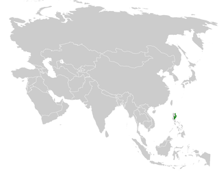
Luzon rain forests

Last updated
Luzon rain forests
Trail Ferns, Mount Makiling - panoramio.jpg
Rainforest in Mount Makiling
Ecoregion IM0123.png
Ecoregion territory (in purple)
Ecology
Realm Indomalayan
Biome tropical and subtropical moist broadleaf forests
Borders
Geography
Area93,358 km2 (36,046 sq mi)
Country Philippines
Conservation
Conservation status Critical/endangered
Protected9,994 km2 (11%) [1]

The Luzon rain forests is a tropical moist broadleaf forest ecoregion on the island of Luzon. Luzon is the largest island in the Philippines, and the Luzon rain forests is the most extensive rainforest ecoregion of the country. The ecoregion includes the lowlands of Luzon and neighboring islands below 1000 meters elevation. Very little of the original rainforest remains, and the status of this area is critical/endangered. [2]

Contents

Geography

Satellite view of the island Luzon Northern Philippines (Luzon).jpg
Satellite view of the island Luzon

The Luzon rain forests encompasses about 95,571 square kilometers (36,900 sq mi) out of the 109,965 sq kilometers (42,458 sq mi) of total area of the island of Luzon. [2] Luzon is the largest and northernmost major island of the Philippines, located in the western Pacific Ocean. The Batanes and Babuyan Islands to the north, Catanduanes and Polillo Islands to the east, and Marinduque to the southwest are considered a part of the Luzon rain forests ecoregion. [2]

The Luzon montane rain forests ecoregion covers areas of the Sierra Madre, Zambales Mountains, and northern Cordillera Central above 1000 meters elevation. The Luzon tropical pine forests covers the central Cordillera Central above 1000 meters elevation.

Geologic history

Luzon has never been connected to mainland Asia. At least 15 million years ago, friction between the Australian and Asian tectonic plates and volcanic activity created parts of the Luzon highlands, which over the next 10 million years morphed into their modern form. [2] This long period of isolation and complex internal geography is a primary cause for the great biodiversity and high degree of endemism found on the island of Luzon. [3]

During the Ice ages, sea levels were up to 120 meters lower than at present. Ice-age Greater Luzon connected Luzon with Catanduanes, Marinduque, the Polillo Islands, and several smaller neighboring islands. The ice-age land bridges allowed the animals and plants of these now-separate islands to mix, which made them part of the same ecoregion. [4]

History

Prehistoric

In 2005, evidence for human occupation in northern Luzon since at least 25,000 years ago, was found in Callao Cave. [5] Evidence included chert flake tools, charred parenchymatous tissues, starch grains, grasses, and Moraceae phytolith. [5] The possibility of hunter-gatherers subsisting in Holocene tropical rain forests without support from agriculturalists was debated, based on the patchy and seasonal resources. [5] Wild forest animals are lean and lacking in calorie-rich fat. [5]

However, hunters and gatherers may have managed by strategizing and moving to correspond to the shifting food resources. [5] Information on skeletal morphology and diet is merely speculative as no human remains were recovered from this time period. This idea is supported by the Sierra Madre Agta of the recent ethnographic past who would plan their movements based on the seasons and available resources; they hunted in the montane forest during the rainy season and in the lowland forest during the summer. [5] Most of their food supply came from fishing, shellfish gathering, wild yams, nuts, and Caryota palms. [5]

In the same cave two years later, in 2007, the same scientist found a metatarsal bone dated to at least around 67,000 years ago, which is speculated to possibly be of Homo sapiens origin. The bone (Right MT3 – the small bone from the end of the middle toe of the right foot) has been identified as belonging to a species of the genus Homo . To tell if the bone belongs to an ancient anatomically modern human, a skull or mandible from the specimen is needed. This fossilized remain from Callao Cave is referred to as Callao Man.

World War II

During World War II, the Japanese invaded the Philippines, and a small band of the Communist Party of the Philippines (CPP) activists used the dense mountain jungles and vast swamps of the Luzon rainforest for protection. [6] The communist activists established a base of operations in the nearby Mt. Arayat and the Candaba Swamp. [6] These activists launched small yet annoying attacks against the Japanese. [6] On December 10, 1941, CPP leaders issued a manifesto vowing their support for the anti-Japanese efforts of the Commonwealth and the United States, and urging the peasants to support this united anti-Japanese front. [6] Resulting was the organization of the Hukbalahap, an acronym for the Hukbong Bayan Laban sa Hapon (the Anti-Japanese Army), in a small lowland forest clearing near Mt. Arayat on March 29, 1942 by the merging of the CPP with the remaining socialist and peasant organizations of Luzon. [6]

Flora

Rain forests on Taal Volcano Crater Lake of Volcano Island.jpg
Rain forests on Taal Volcano

The rainforest of the lowlands encompass all areas below 1,000 metres (3,300 ft) in elevation. [2] Much of the lowland rainforest has been destroyed by human deforestation activities. [3]

Dipterocarp trees with wide buttresses dominate this area. [7] These trees are massive, growing up to 60 metres (200 ft) tall with diameters between 1–2 metres (3.3–6.6 ft). [2] Vatica pachyphylla is a critically endangered tree species endemic to the ecoregion. [8]

The mature lowland forests tend to have an uneven canopy height. Rattans and lianas grow in the understory, receiving the light they need to thrive through areas of disturbance. [2] There is generally a large amount of herbaceous undergrowth, with epiphytic ferns and orchids growing on the thick branches of tall trees. [2]

Montane forests

Mature forest in the crater floor of Mount Cagua Mature forest in the crater floor of Mt. Cagua - ZooKeys-266-001-g014.jpg
Mature forest in the crater floor of Mount Cagua
The Sierra Madre mountain range. Ultrabasic forests above 1200 m at Barangay Diddadungan - ZooKeys-266-001-g006.jpg
The Sierra Madre mountain range.

Above 1,000 metres (3,300 ft) elevation, the Luzon rain forests transition to the Luzon montane rain forests ecoregion. Montane rain forests are found in the Northern and Southern Sierra Madre, Mt. Sapacoy, Mt. Magnas, and Mt. Agnamala in the northern Cordillera Central highlands, and in the Zambales Mountains in the west. In the south of the island, enclaves of montane forest can be found on several volcanic and non-volcanic mountains that exceed meters elevation. The volcanic mountains include Mt. Makiling, Mt. Banahaw, Mt. Isarog, Mayon Volcano, and Bulusan Volcano. [2] [7]

In some areas, annual rainfall can be about quadruple what the lowland rainforests receive (as high as 10,000 mm). [7] The Sierra Madres have very mild seasons, with a slight dry period between December and April. The Zambales Mountains and northern Central Cordillera highlands are more strongly seasonal with a longer dry period and slightly less rainfall generally. [7]

The dipterocarp trees of the lowlands are gradually replaced by oak and laurel forest species with increasing altitude. [7] The forests generally have less undergrowth and become shorter in stature as altitude increases. [7] With the decreasing temperature from increasing altitude, decomposition is slowed and results in a forest floor thick with humus. [7]

In the montane forests, epiphytes, vines, and moss-covered branches are very common. [7] The highest altitudes of montane forests are caller upper montane forest, or elfin forest, and are more extreme: trees are shorter in stature, and tree branches are so thick with moss and organic material that they can sustain aerial plants that are not typically epiphytes. [7] Many endemic animal species reside in the thick, matty soil of the upper montane forests. [7]

In fact, species richness is greatest along the highest elevations of the montane rainforests of Luzon. [3] Areas with the greatest levels of endemism are reported to be the Cordillera Central highlands, the Sierra Madre, the Zambales Mountains, and highlands on the Bicol Peninsula. [3]

Fauna

There are at least 31 endemic species of mammals on the island of Luzon. [9] Sixty-eight percent of all known native non-flying mammals are endemic to the area (23 of 34). [3]

The Philippine eagle Pithecophaga jefferyi.jpg
The Philippine eagle

The Philippine eagle (Pithecophaga jefferyi), one of the largest eagles in the world, is found primarily in the Sierra Madre of Luzon. [9] [10] Primary lowland rainforests of the Philippines have been heavily deforested, and the Philippine eagle needs this area to breed, as well as nesting in large trees and hunting within the trees. [9] [10] The eagle is restricted to the islands of Luzon, Samar, Leyte, and Mindanao. [10] Attempts for captive breeding have been unsuccessful and it is estimated that less than 700 individuals remain. [9]

Often called Myer’s snake in honor of Dr. George S. Myers, the genus Myersophis represented only by the species alpestris. It is a snake found only in the northern highlands of Luzon. [11]

Opening in jungle canopy at Mount Makiling Opening In Jungle Canopy, Mt Makiling - panoramio.jpg
Opening in jungle canopy at Mount Makiling

About sixty-eight percent of all native reptiles are endemic to the area (about 160 of 235). [9] The Philippine crocodile, Crocodylus mindorensis, is a freshwater crocodile that is considered the most threatened crocodile in the world and is endemic to the Philippines; it is only found in Mindanao, Negros, and Luzon. [12] Wild populations in 1982 totaled somewhere between 500 and 1000 individuals. [9] In 1995, this number decreased to a mere 100 individuals. [9] The discovery of a population of this crocodile in the Northern Sierra Madre on Luzon gives hope for its conservation. [12] Active in the conservation of Crocodylus mindorensis is the Crocodile Rehabilitation Observance and Conservation (CROC) Project of the Mabuwaya Foundation. [9]

The Sierra Madres give hope to many other threatened animals by providing one of the largest areas of intact rainforest in the Philippines thereby maintaining the naturally high level of biodiversity. [10] Many species of threatened birds are found in this location. [10]

Conservation

A 2017 assessment found that 9,994 km2, or 11%, of the island is in protected areas. [1] Protected areas in the ecoregion include: [13]

See also

Related Research Articles

The Global 200 is the list of ecoregions identified by the World Wide Fund for Nature (WWF), the global conservation organization, as priorities for conservation. According to WWF, an ecoregion is defined as a "relatively large unit of land or water containing a characteristic set of natural communities that share a large majority of their species dynamics, and environmental conditions". For example, based on their levels of endemism, Madagascar gets multiple listings, ancient Lake Baikal gets one, and the North American Great Lakes get none.

<span class="mw-page-title-main">Temperate rainforest</span> Forests in the temperate zone

Temperate rainforest are coniferous or broadleaf forests that occur in the temperate zone and receive heavy rain.

<span class="mw-page-title-main">Laurel forest</span> Type of subtropical forest

Laurel forest, also called laurisilva or laurissilva, is a type of subtropical forest found in areas with high humidity and relatively stable, mild temperatures. The forest is characterized by broadleaf tree species with evergreen, glossy and elongated leaves, known as "laurophyll" or "lauroid". Plants from the laurel family (Lauraceae) may or may not be present, depending on the location.

<span class="mw-page-title-main">New Guinea Highlands</span> Natural region in New Guinea

The New Guinea Highlands, also known as the Central Range or Central Cordillera, is a long chain of mountain ranges on the island of New Guinea, including the island's tallest peak, Puncak Jaya, Indonesia, 16,024 ft (4,884 m), the highest mountain in Oceania. The range is home to many intermountain river valleys, many of which support thriving agricultural communities. The highlands run generally east-west the length of the island, which is divided politically between Indonesia in the west and Papua New Guinea in the east.

<span class="mw-page-title-main">South Malawi montane forest–grassland mosaic</span>

The South Malawi montane forest–grassland mosaic is an ecoregion of Malawi.

<span class="mw-page-title-main">Borneo lowland rain forests</span> Ecoregion in Borneo

The Borneo lowland rain forests is an ecoregion, within the tropical and subtropical moist broadleaf forests biome, of the large island of Borneo in Southeast Asia. It supports approximately 15,000 plant species, 380 bird species and several mammal species. The Borneo lowland rain forests is diminishing due to logging, hunting and conversion to commercial land use.

<span class="mw-page-title-main">Huon Peninsula montane rain forests</span>

The Huon Peninsula montane rain forests is a tropical moist forest ecoregion in New Guinea. The ecoregion covers the mountains of northeastern New Guinea's Huon Peninsula.

<span class="mw-page-title-main">Luzon tropical pine forests</span>

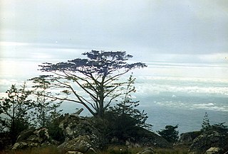
The Luzon tropical pine forests are a tropical coniferous forest ecoregion of the Philippines in the western Pacific Ocean. These pine forests are home to a large number of the island's endemic plants and animals.

<span class="mw-page-title-main">Samoan tropical moist forests</span> Tropical moist broadleaf forests ecoregion of the Samoan Islands

The Samoan tropical moist forests are a tropical moist broadleaf forest ecoregion in the Samoan Islands of the Pacific Ocean.

<span class="mw-page-title-main">Puerto Rican moist forests</span> Ecoregion in Puerto Rico

The Puerto Rican moist forests are a tropical moist broadleaf forest ecoregion in Puerto Rico. They cover an area of 7,544 km2 (2,913 sq mi).

<span class="mw-page-title-main">Sierra Madre ground warbler</span> Species of bird

The Sierra Madre ground warbler is a species of passerine bird in the family Locustellidae. It is endemic to the island of Luzon in the Philippines, where it is found in the northeastern and eastern foothills of the Sierra Madre. Its habitat is in tropical moist lowland and the lower reaches of tropical montane forest. Along with its closest relatives, the Cordillera ground warbler and the Bicol ground warbler, it is one of the most elusive birds in the country due to its extremely shy nature. While not officially threatened, its population is said to be declining due to habitat destruction through deforestation.

<span class="mw-page-title-main">Northern Sierra Madre Natural Park</span>

The Northern Sierra Madre Natural Park is the largest protected area of the Philippines covering the northern range of the Sierra Madre mountains of eastern Luzon. The park is located in the eastern part of the province of Isabela in Cagayan Valley containing a total of 359,486 hectares. It was first declared a wilderness reserve encompassing an area within a 45 kilometres (28 mi) radius of Palanan Point known as the Palanan Wilderness Area through Letter of Instructions No. 917-A signed by President Ferdinand Marcos on September 7, 1979. On March 10, 1997, the area was converted into a natural park with the signing of Proclamation No. 978 by President Fidel Ramos.

<span class="mw-page-title-main">Sierra Madre (Philippines)</span> Mountain range in the Philippines

The Sierra Madre is the longest mountain range in the Philippines. Spanning over 540 kilometers (340 mi), it runs from the province of Cagayan down to the province of Quezon, forming a north–south direction on the eastern portion of Luzon, the largest island of the archipelago. It is bordered by the Pacific Ocean to the east, Cagayan Valley to the northwest, Central Luzon to the midwest, and Calabarzon to the southwest. Some communities east of the mountain range, along the coast, are less developed and so remote that they could only be accessed by taking a plane or a boat.

<span class="mw-page-title-main">Santa Marta montane forests</span>

The Santa Marta montane forests (NT0159) is an ecoregion in the Sierra Nevada de Santa Marta, a massif on the Caribbean coast of northern Colombia. The ecoregion covers altitudes from near sea level up to around 3,300 metres (10,827 ft), where it gives way to Santa Marta páramo. The isolation of the massif and the range of elevations and climates has resulted in a wide variety of species including many endemics. The lower levels contained tropical rainforest, which has largely been cleared. Higher up, this gives way to cloud forest. Much of this has also been cleared for coffee plantations, pasture for sheep and cattle, and farming.

<span class="mw-page-title-main">Luzon montane rain forests</span> Ecoregion in Luzon, the Philippines

The Luzon montane rain forests is a tropical moist broadleaf forest ecoregion on the island of Luzon in the Philippines. The ecoregion is located on several volcanic and non-volcanic mountains of the island. Luzon is the largest and northernmost major island of the Philippines, located in the western Pacific Ocean.

<span class="mw-page-title-main">Sulawesi montane rain forests</span> Ecoregion in Sulawesi, Indonesia

The Sulawesi montane rain forests is a tropical moist forest ecoregion in Indonesia. It includes the highlands of Sulawesi.

<span class="mw-page-title-main">Vogelkop montane rain forests</span> Ecoregion in New Guinea

The Vogelkop montane rain forests is a tropical moist forest ecoregion in western New Guinea. The ecoregion covers the mountains of western New Guinea's Bird's Head and Bomberai peninsulas.

<span class="mw-page-title-main">Mindanao montane rain forests</span> Ecoregion in Mindanao, the Philippines

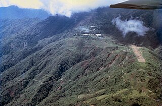
The Mindanao montane rain forests ecoregion covers the montane forests - the zone between the lowland forest and the treeline - in the mountains on the island of Mindanao in the Philippines. Because the ecoregion covers only elevations above 1,000 metres (3,300 ft), it exists in seven discontinuous patches surrounded by lowland rainforest. Biodiversity is high, both because of the isolation of separate mountain ranges that have led to species variation within the island, and because of the altitude zonation. Because most of the surrounding lowland forest has been cleared for human use, the montane regions have become an important refuge for rare and endemic species.

<span class="mw-page-title-main">Greater Negros–Panay rain forests</span> Ecoregion in the Philippines

The Greater Negros–Panay rain forests ecoregion covers the central Visayan Islands in the Philippines, including the islands of Panay, Negros, Cebu, Masbate, Sibuyan, Ticao, Guimaras, Romblon, Tablas, Siquijor, and Bohol, but excludes Leyte and Samar. During the last ice age, these were all on the same island. The lack of a land bridge to Asia during the ice age kept most Asian megafauna, including elephants and tigers, from reaching the Philippines and the Visayan Islands, which hosts many unique and endemic species with some exclusive only to an island.

References

  1. 1 2 Eric Dinerstein, David Olson, et al. (2017). An Ecoregion-Based Approach to Protecting Half the Terrestrial Realm, BioScience, Volume 67, Issue 6, June 2017, Pages 534–545; Supplemental material 2 table S1b.
  2. 1 2 3 4 5 6 7 8 9 Lamoreux, John. "Luzon fain forests". WWF - Endangered Species Conservation. World Wildlife Fund, n.d. 24 May 2013.
  3. 1 2 3 4 5 Rickart, E. A.; Heaney, L. R.; Balete, D. S.; Tabaranza, Jr. (2010). "Small Mammal Diversity Along An Elevational Gradient In Northern Luzon, Philippines". Mammalian Biology - Zeitschrift für Säugetierkunde. 76 (1): 12–21. doi:10.1016/j.mambio.2010.01.006.
  4. Wikramanayake, Eric; Eric Dinerstein; Colby J. Loucks; et al. (2002). Terrestrial Ecoregions of the Indo-Pacific: a Conservation Assessment. Washington, DC: Island Press.
  5. 1 2 3 4 5 6 7 Mijares, Salvador B.; Armand (2008). "The Late Pleistocene to Early Holocene Foragers of Northern Luzon". Bulletin of the Indo-Pacific Prehistory Association. 28: 99–107. doi:10.7152/bippa.v28i0.12022.
  6. 1 2 3 4 5 Greenberg, Major Lawrence M. "The Hukbalahap Insurrection: A Case Study of a Successful Anti-Insurgency Operation in the Philippines, 1946-1955." Historical Analysis Series 93-8 (1987). U.S. Army Center of Military History. Web. 2 June 2013.
  7. 1 2 3 4 5 6 7 8 9 10 McGinley, Mark. "Luzon Montane Rain Forests". The Encyclopedia of Earth. World Wildlife Fund, 30 May 2007. 24 May 2013.
  8. 2006 IUCN Red List of Threatened Species, Critically Endangered A1cd ver 2.3: Report for Vatica pachyphylla; Ashton, P. 1998 . accessed 10.31.2016.
  9. 1 2 3 4 5 6 7 8 "Philippines". Conservation International (24 May 2013)
  10. 1 2 3 4 5 Poulsen, M. K. (1995). "The Threatened and Near-Threatened Birds of Luzon, Philippines, and the Role of the Sierra Madre Mountains in Their Conservation". Bird Conservation International. 5 (1): 79–115. doi: 10.1017/s0959270900002963 .
  11. Taylor, E. H. (1963). "New and Rare Oriental Serpents". Copeia. 1963 (2): 429–433. doi:10.2307/1441364. JSTOR   1441364.
  12. 1 2 Ploeg; Weerd (2003). "A New Future for the Philippine Crocodile, Crocodylus mindorensis" (PDF). The Technical Journal of Philippine Ecosystems and Natural Resources. 13 (1&2): 31–50.
  13. "Philippines". Protected Planet, accessed 13 May 2020