Bulusan Volcano Natural Park

Last updated
Bulusan Volcano Natural Park
Bulusan Park = Allan Jay Quesada.jpg
Philippines Sorsogon relief location map.svg
Red pog.svg
Location in Sorsogon
Philippines relief location map (square).svg
Red pog.svg
Bulusan Volcano Natural Park (Philippines)
Location Sorsogon, Philippines
Nearest city Sorsogon City
Coordinates 12°46′12″N124°03′00″E / 12.77000°N 124.05000°E / 12.77000; 124.05000
Area3,672 hectares (9,070 acres)
EstablishedJune 7, 1935 (National park)
November 27, 2000 (Natural park)
Governing body Department of Environment and Natural Resources

The Bulusan Volcano Natural Park is a 3,673-hectare (9,080-acre) protected area of rainforest surrounding Mount Bulusan in the Philippines. [1] It was first designated as a National Park [2] by Proclamation no. 811 on June 7, 1935. [3] Under the National Integrated Protected Areas System (NIPAS) of 1992 managed by the Department of the Environment and Natural Resources, the park was reclassified as a Natural Park by Proc. 421 on November 27, 2000. [4] The area features the volcano itself, Bulusan Lake, the two other mountains known as the 'Sharp Peak' and 'Hormahan' and Lake Aguingay. The park is in the south central part of Sorsogon Province, southern Luzon, Bicol Region, Philippines, bounded by five municipalities: Bulusan, Barcelona, Irosin, Juban and Casiguran.

Contents

Physical characteristics and biodiversity

There are three main peaks in the park — the active Bulusan Volcano, the highest, which is characterized by numerous deep ravines and caves — Sharp Peak, and the mountain called Hormahan.

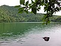
The center of the mountain complex forms a vast plain that is occasionally flooded known as Lake Aguingay, which dries up during summer. Another lake in the park is Lake Bulusan. A substantial area of forest remains in the park, including forest around the peak and lowland forest on the slopes. Other habitats include secondary grassland, freshwater lakes and pools, small settlements and rural gardens, abandoned farmland and disturbed ground.

The park supports the needs of the nearby communities through its forest products, watershed, and recreational values. Local communities use the lower slopes as agricultural land. It is the source of water for several communities and for the irrigation of surrounding agricultural land, and it provides natural protection from calamities such as typhoons and flash floods.

Flora

Giant ferns: the most common vegetation found in the park. Giant Ferns of Bulusan.jpeg
Giant ferns: the most common vegetation found in the park.

The most common vegetation is the giant ferns and tall trees such as the red lauan ( Shorea teysmanniana ), molave ( Vitex parviflora ) and many others. Other plant species including ground orchids. Two endemic plant species, Thelypteris bulusanica (a fern) and Heptapleurum caudatifolium , are found in the area.

Fauna

Some animals are in the area, such as the Philippine baboon, Philippine duck, Philippine hawk-eagle, flame-breasted fruit-dove, Philippine eagle-owl, [5] monitor lizards, endemic frogs, snakes, and other reptiles. [6] Philippine brown deer, warty pigs and rare civets were spotted in the area in the late 1980s, although there is no evidences of their existence in the park at present. The park also supports endangered species of frogs, lizards, bats, snakes and other reptiles.

Management and conservation

As the natural habitats declined over the years as a result of extensive kaingin , heavy hunting, and human settling, cooperating municipalities especially Bulusan and Irosin joined in responding to conservation efforts. [7] Plans have been drawn with the support from DENR, local communities, local government units, non-government organizations and concerned citizens for the rehabilitation of affected areas and protection of remaining untouched forests. Eco-tourism has been encouraged to give more jobs to the locals to limit the use of produce found in the park.

See also

Related Research Articles

<span class="mw-page-title-main">Sorsogon</span> Province in Bicol, Philippines

Sorsogon, officially the Province of Sorsogon, is a province in the Philippines located in the Bicol Region. It is the southernmost province in Luzon and is subdivided into fourteen municipalities (towns) and one city. Its capital is Sorsogon City and borders the province of Albay to the north.

<span class="mw-page-title-main">Bicol Region</span> Administrative region of the Philippines

The Bicol Region, commonly shortened to Bicol and designated as Region V, is an administrative region of the Philippines. Also referred to as Bicolandia, it comprises six provinces, four on the Bicol Peninsula : Albay, Camarines Norte, Camarines Sur, and Sorsogon, and two off the shore: Catanduanes and Masbate.

<span class="mw-page-title-main">Camarines Sur</span> Province in Bicol, Philippines

Camarines Sur, officially the Province of Camarines Sur, is a province in the Philippines located in the Bicol Region on Luzon. Its capital is Pili and the province borders Camarines Norte and Quezon to the northwest, and Albay to the south. To the east lies the island province of Catanduanes across the Maqueda Channel.

<span class="mw-page-title-main">Mount Apo</span> Dormant volcano in the Philippines

Mount Apo, also known locally as Apo Sandawa, is a large solfataric, dormant stratovolcano on the island of Mindanao, Philippines. With an elevation of 2,954 meters (9,692 ft) above sea level, it is the highest-mountain in the Philippine Archipelago, Mindanao and 24th-highest peak of an island on Earth. Located on the tripartite border of Davao City and Davao del Sur in the Davao Region, and Cotabato in Soccsksargen, Mount Apo is the most-prominent mountain in the Philippines. The peak overlooks from Davao City 45 kilometers (28 mi) to the northeast, Digos 25 kilometers (16 mi) to the southeast, and Kidapawan 20 kilometers (12 mi) to the west. It is a protected area and a Natural Park of the Philippines.

<span class="mw-page-title-main">Mount Banahaw</span> Active volcano in the Philippines

Mount Banahaw is an active complex volcano on Luzon in the Philippines. The three-peaked volcano is located at the boundary of Laguna and Quezon provinces. It is the highest mountain in both provinces and Calabarzon region, dominating the landscape for miles around.

<span class="mw-page-title-main">Bulusan (municipality)</span> Municipality in Sorsogon, Philippines

Bulusan, officially the Municipality of Bulusan, is a 4th class municipality in the province of Sorsogon, Philippines. According to the 2020 census, it has a population of 23,932 people.

<span class="mw-page-title-main">Irosin</span> Municipality in Sorsogon, Philippines

Irosin, officially the Municipality of Irosin, is a 2nd class municipality in the province of Sorsogon, Philippines. According to the 2020 census, it has a population of 59,267 people.

<span class="mw-page-title-main">Mount Bulusan</span> Volcano in the Philippines

Mount Bulusan, also known as Bulusan Volcano, is a stratovolcano on the island of Luzon in the Philippines. Located in the province of Sorsogon in the Bicol Region, it is 70 kilometres (43 mi) southeast of Mayon Volcano and approximately 390 kilometres (240 mi) southeast of Manila. Bulusan is one of the active volcanoes in the Philippines.

<span class="mw-page-title-main">Mount Isarog</span> Active volcano in Camarines Sur, Philippines

Mount Isarog is an active stratovolcano located in the province of Camarines Sur, Philippines, on the island of Luzon. The mountain has active fumaroles and hot springs. It has an elevation of 2,011.6 m (6,600 ft) above mean sea level.

<span class="mw-page-title-main">Mount Talinis</span> Complex volcano in the Philippine province of Negros Occidental

Mount Talinis is a complex volcano in the Philippine province of Negros Oriental. At about 1,903 metres (6,243 ft) above sea level, it is the second highest mountain on Negros Island after Mount Kanlaon, and the tallest peak in the mountain range known as the Cuernos de Negros. The volcano is located 9 km (5.6 mi) southwest of the municipality of Valencia; and 20 km (12 mi) from Dumaguete, the capital of the province.

<span class="mw-page-title-main">Mount Malindang</span> Volcano in the Philippines

Mount Malindang is a complex volcano located in the province of Misamis Occidental in the southern island of Mindanao, Philippines. It is the highest point in the province. The least studied mountain range was formed through several volcanic activities some of which could be historical, evident by the presence of two calderas, surrounded by high rock walls, cinder cones, dome volcano plugs, two sulfurous hot springs, and a crater lake named Lake Duminagat. The amphitheater structures have extensive distribution of volcanic rocks, carbonized wood that are found in pyroclastic deposits. The mountain range is dissected by several canyons and ravines.

Mahagnao Volcano also known as part of is a dormant stratovolcano located in the Barangay Mahagnao part of the municipality of Burauen province of Leyte, Philippines. It is also bounded by the municipalities of La Paz and MacArthur. The area is mostly composed of wetland forests and also the birth of many rivers and streams flowing on many part of Burauen and on its neighboring towns.

<span class="mw-page-title-main">Lake Bulusan</span> Crater lake in Luzon Island

Lake Bulusan is a lake on Luzon Island in the Philippines. It lies at the heart of Bulusan Volcano National Park which covers a land area of 3,672 hectares. It has an elevation of 360 metres (1,180 ft) and is located on the southeast flank of Mount Bulusan, an active volcano.

<span class="mw-page-title-main">Lake Aguingay</span> Seasonal crater lake in Luzon Island

Lake Aguingay is a vast plain at the center of Bulusan Volcano National Park located near Bulusan Lake at the Municipality of Bulusan, South central part of the Sorsogon Province, Southern Luzon, Bicol Region, Philippines. It is called The Lake because it is occasionally flooded during wet season and dries up during summer. When it is wet it resembles a big lake located right at the foot of Mt. Bulusan. The area is home to various endemic birds, reptiles and other mammals. It is surrounded by lush vegetation and a tropical rain forest. It is only accessible by foot from Bulusan Lake and from the villages of Kapangihan and San Roque.

<span class="mw-page-title-main">Mayon Volcano Natural Park</span> Natural park

The Mayon Volcano Natural Park is a protected area of the Philippines located in the Bicol Region on southeast Luzon Island, the largest island of the country. The Natural park covers an area of 5,775.7 hectares, which includes its centerpiece Mayon Volcano, the most active volcano in the Philippines, and its adjacent surroundings. The volcano is also renowned for having an almost perfect cone. First protected as a National Park in 1938, it was reclassified as a Natural Park in the year 2000.

<span class="mw-page-title-main">Luzon rain forests</span> Ecoregion in Luzon, the Philippines

The Luzon rain forest is a tropical moist broadleaf forest ecoregion on the island of Luzon. Luzon is the largest island in the Philippines, and the Luzon rain forest is the most extensive rainforest ecoregion of the country. The ecoregion includes the lowlands of Luzon and neighboring islands below 1000 meters elevation. Very little of the original rainforest remains, and the status of this area is critical/endangered.

<span class="mw-page-title-main">Bicol Natural Park</span> Protected area of the Philippines

The Bicol Natural Park is a protected area of the Philippines located in the Bicol Region of southern Luzon. It straddles the mountainous border between the provinces of Camarines Norte and Camarines Sur in the northern interior of the Bicol Peninsula. First declared as a national park covering 4,225 hectares on 13 February 1934 through Proclamation No. 657 of Governor General Frank Murphy, the Bicol National Park was later extended to its present area of 5,201 hectares through amendments made in Proclamation No. 655 signed by President Manuel Luis Quezon on 23 December 1940. The area was reclassified as a natural park on 29 December 2000 by virtue of Proclamation No. 43 by President Joseph Estrada.

Bongsanglay Natural Park is a protected area of mangrove forests and swamps on Ticao Island in the Bicol Region of the Philippines. It is located in the municipality of Batuan in the island province of Masbate covering an area of 244.72 hectares. The protected area was established on 29 December 1981 when the area "from Panciscan Point in Bitos Bay up to Bano Sanlay" in Batuan was declared a Mangrove Swamp Forest Reserve under Proclamation No. 2152 signed by President Ferdinand Marcos. In 2000, when President Joseph Estrada signed Proclamation No. 319, Bongsanglay was reclassified as a natural park pursuant to the National Integrated Protected Areas System (NIPAS) Act.

<span class="mw-page-title-main">Luzon montane rain forests</span> Ecoregion in Luzon, the Philippines

The Luzon montane rain forests is a tropical moist broadleaf forest ecoregion on the island of Luzon in the Philippines. The ecoregion is located on several volcanic and non-volcanic mountains of the island. Luzon is the largest and northernmost major island of the Philippines, located in the western Pacific Ocean.

<i>Pinoyscincus jagori</i> Species of lizard

Jagor's sphenomorphus is a species of skink, a lizard in the family Scincidae. The species is endemic to the Philippines. There are two recognized subspecies.

References

  1. "Bulusan Volcano National Park". Waypointsdotph. Archived from the original on 2012-05-10. Retrieved 2012-04-03.
  2. "Philippine Fifth Congress Acts". congress.gov.ph. Archived from the original on 2015-09-23. Retrieved 2012-04-03.
  3. "Initial Components of the NIPAS Act" (Tables). Archived from the original on 2013-10-04. Retrieved 2012-06-18 via Protected Areas and Wildlife Bureau.
  4. "Protected Areas of Region 5". Protected Areas and Wildlife Bureau. March 11, 2010. Archived from the original on 2012-03-21. Retrieved 2012-06-18.
  5. "Bulusan Volcano National Park". BirdLife International. Archived from the original on 2016-03-04. Retrieved 2012-04-03.
  6. "Bulusan Volcano National Park". philippinen-reisen. Retrieved 2012-04-03.[ permanent dead link ]
  7. "Bicol Environmental Management". Bicol Man. Archived from the original on 2012-09-14. Retrieved 2012-04-03.