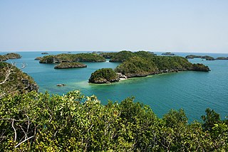
The Hundred Islands National Park is the first Philippine national park and a protected area located in Alaminos, Pangasinan. The islands, totaling 124 at low tide and 123 at high tide, are scattered in Lingayen Gulf covering an area of 16.76 square kilometres (6.47 sq mi). Only four of them had been developed for tourism: Quezon Island, Governor Island, Children's Island, and Pilgrimage Island.

Viga, officially the Municipality of Viga, is a municipality in the province of Catanduanes, Philippines. According to the 2020 census, it has a population of 22,869 people.
Batuan, officially the Municipality of Batuan, is a municipality in the province of Masbate, Philippines. According to the 2020 census, it has a population of 14,610 people.

San Fernando, officially the Municipality of San Fernando, is a municipality in the province of Masbate, Philippines. According to the 2020 census, it has a population of 21,600 people.

Bao BolongWetland Reserve is a protected area in The Gambia. Established in 1996, it covers 296.5 square kilometres.
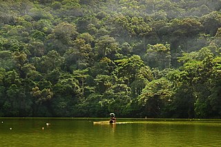
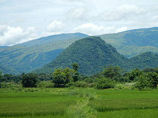
The Bulusan Volcano Natural Park is a 3,673-hectare (9,080-acre) protected area of rainforest surrounding Mount Bulusan in the Philippines. It was first designated as a National Park by Proclamation no. 811 on June 7, 1935. Under the National Integrated Protected Areas System (NIPAS) of 1992 managed by the Department of the Environment and Natural Resources, the park was reclassified as a Natural Park by Proc. 421 on November 27, 2000. The area features the volcano itself, Bulusan Lake, the two other mountains known as the 'Sharp Peak' and 'Hormahan' and Lake Aguingay. The park is in the south central part of Sorsogon Province, southern Luzon, Bicol Region, Philippines, bounded by five municipalities: Bulusan, Barcelona, Irosin, Juban and Casiguran.
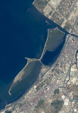
The Las Piñas–Parañaque Critical Habitat and Ecotourism Area (LPPCHEA), also known as the Las Piñas–Parañaque Wetland Park, is a protected area at the coasts of the cities of Las Piñas and Parañaque in Metro Manila, Philippines. The entire wetland is a declared Ramsar site under the Ramsar Convention of UNESCO.

The Bicol Natural Park is a protected area of the Philippines located in the Bicol Region of southern Luzon. It straddles the mountainous border between the provinces of Camarines Norte and Camarines Sur in the northern interior of the Bicol Peninsula. First declared as a national park covering 4,225 hectares on February 13, 1934, through Proclamation No. 657 of Governor General Frank Murphy, the Bicol National Park was later extended to its present area of 5,201 hectares through amendments made in Proclamation No. 655 signed by President Manuel Luis Quezon on December 23, 1940. The area was reclassified as a natural park on December 29, 2000, by virtue of Proclamation No. 43 by President Joseph Estrada.
The Manleluag Spring Protected Landscape is a protected area containing natural hot springs in the Ilocos Region of the Philippines. It is one of 34 protected landscapes in the Philippines located in the municipality of Mangatarem, Pangasinan in the west-central area of the island of Luzon.

The Magapit Protected Landscape is a protected area of forested limestone hills and grasslands in the Cagayan Valley of northern Luzon island in the Philippines. It covers an area of 3,403.62 hectares in northeastern Cagayan province straddling the municipalities of Lal-lo and Gattaran. The park was established as a game refuge and bird sanctuary on 15 August 1947 covering an initial area of 4,554 hectares declared through Administrative Order No. 10 by President Manuel Roxas. On 23 April 2000, the park was redesignated as a protected landscape area under the National Integrated Protected Areas System Act through Proclamation No. 285 signed by President Joseph Estrada. The park is a component of the Northeastern Cagayan Key Biodiversity Area and also contains the Lal-lo and Gattaran Shell Middens, a proposed World Heritage Site.

The Rajah Sikatuna Protected Landscape is a protected landscape area of forested limestone hills, grasslands and natural springs in the island province of Bohol in the Central Visayas region of the Philippines. It is the largest remaining tract of natural forest in Bohol and one of the Philippines' top birdwatching sites. The park was initially gazetted a national park in 1987 covering approximately 9,023 hectares. In 2000, it was reestablished as a protected landscape under the National Integrated Protected Areas System covering its present area of 10,452.6 hectares. The park is one of the island's major tourist attractions located just south of the famous Chocolate Hills. It was named after the Bohol chieftain who entered into a blood-compact with Spanish conquistador Miguel López de Legazpi on the island in 1565.

The Pasonanca Natural Park is a protected area that preserves a major watershed in the southern Philippine island of Mindanao in the Zamboanga Peninsula. It contains the headwaters of the Tumaga River in the southern Zamboanga Cordillera mountain range that serves the water requirements of some 800,000 residents in Zamboanga City. It was named after the village of Pasonanca located in the city's northern fringes where the Pasonanca Park, a public eco-park, and the Abong-Abong Park, a pilgrimage site, can also be found.
The Mainit Hot Springs Protected Landscape is a protected landscape area located in the province of Davao de Oro on the island of Mindanao in the Philippines. It preserves the sulfuric hot springs and surrounding forest in Nabunturan municipality which also contains the headwaters of the Manat River, a source of water supply for surrounding villages. First declared a national park in 1957 by virtue of Proclamation No. 466 by President Carlos P. Garcia, it had an initial area of 1,381 hectares. Under the National Integrated Protected Areas System, it was reclassified as a protected landscape through Proclamation No. 320 issued in 2000 by President Joseph Estrada. The hot springs are a popular ecotourist attraction in Davao de Oro. Its name "Mainit" is a Filipino word which means hot.

The La Mesa Watershed Reservation is a protected area that preserves the only major watershed in Metro Manila, Philippines. Also known as the Novaliches Watershed, it contains the last remaining rainforest of its size in Metro Manila surrounding the La Mesa Dam and Reservoir, the primary source of potable drinking water for 12 million residents in the Manila metropolitan area. The area is under jointly controlled and supervised by the Department of Environment and Natural Resources and the Metropolitan Waterworks and Sewerage System. It was established in 2007 through Proclamation No. 1336 issued by President Gloria Macapagal Arroyo.
Rasa Island is a flat coral island in the Sulu Sea just off the coast of the municipality of Narra in Palawan, Philippines. It is a shallow island surrounded by mangroves and tidal flats containing one of the country's last remaining coastal forests. The island is home to the largest population of the endemic and critically endangered Philippine cockatoo in the wild in the Philippines. It was declared a protected area in 2006.

Balinsasayao Twin Lakes Natural Park is a natural park in the Philippines surrounding Lake Balinsasayao and Lake Danao in the province of Negros Oriental, 14.5 kilometres (9.0 mi) west of Dumaguete. It covers an area of 8,016.05 hectares, with heights ranging from 830 to 846 metres. The park is located in the Mount Talinis range, also known as Cuernos de Negros, in the southern portion of Negros Island, and spans across the municipalities of Valencia, Sibulan and San Jose. It was declared a protected area in 2000. In 2024, the ASEAN Centre for Biodiversity (ACB) is now listed The Balinsasayao Twin Lakes Natural Park among new parks to its network of topnotch nature reserves and natural parks in the Southeast Asian region.
Alibijaban is a small island located off the southeastern coast of Bondoc Peninsula in the island of Luzon. It belongs administratively to the municipality of San Andres, Quezon province, and is coterminous with the barangay of the same name. With a population of 1,738 inhabitants in 2020, it is the smallest of seven barangays in San Andres.
Malabungot, alternatively spelled as Malabungut, and also known as Mahad, is an island in Binagasbasan Bay off the coast of Garchitorena in Camarines Sur, Philippines. It is separated from Caramoan Peninsula in the south by the Quinalasag Passage, also known as Sisiran Passage, which connects Lamit and Sisiran bays. The island forms the head of Binagasbasan Bay, bordered to the west by the Lamit Islands and to the east by Quinalasag Island, and which opens northward to the Philippine Sea. It is designated as a protected landscape and seascape on account of its biodiversity and ecological significance.

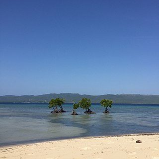
The Baliangao Protected Landscape and Seascape is a wetland conservation area along the coast of Danao Bay in northern Misamis Occidental, Philippines. Situated on the territory of four barangays in the municipality of Baliangao, it covers 294.10 hectares of terrestrial and marine areas consisting of mangrove, sea grass and coral reef ecosystems. The protected area also includes a portion of Sinian River which drains into Danao Bay. It was established in 2000 through Proclamation No. 418.
