
Camarines Sur is a province in the Philippines located in the Bicol Region in Luzon. Its capital is Pili and the province borders Camarines Norte and Quezon to the northwest, and Albay to the south. To the east lies the island province of Catanduanes across the Maqueda Channel.

Caramoan, officially the Municipality of Caramoan, is a 2nd class municipality in the province of Camarines Sur, Philippines. According to the 2020 census, it has a population of 51,728 people.

Garchitorena, officially the Municipality of Garchitorena, is a 4th class municipality in the province of Camarines Sur, Philippines. According to the 2020 census, it has a population of 29,436 people.
San Miguel Bay is a large bay in the Bicol Peninsula of Luzon island in the Philippines. It encompasses the provinces of Camarines Norte and Camarines Sur.
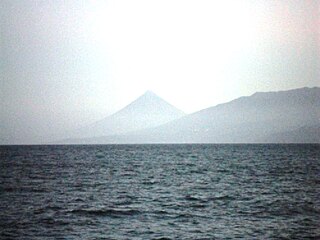
Lagonoy Gulf is a large gulf in the Bicol Peninsula of Luzon island in the Philippines. It is separated from the Philippine Sea by the Caramoan Peninsula in the north; and is separated from Albay Gulf in the south by a chain of islands including Batan Island and Rapu-rapu Island. It is about 3,070 square kilometres (1,190 sq mi) in area, with 80% of its area between 800 metres (2,600 ft) and 1,200 metres (3,900 ft) deep.

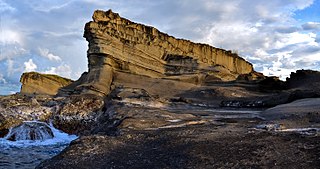
The Caramoan National Park is a 347-hectare (860-acre) national park and protected area in Camarines Sur, Philippines. It was established in 1938. The park has caves, limestone formations, white sandy beaches, an islet lake and a subterranean river, make it popular with tourists. It is accessible by public transport from the municipality of Caramoan, and local people have established trails in the park for visitors.

The legislative districts of Camarines Sur are the representations of the province of Camarines Sur and the independent city of Naga in the various national legislatures of the Philippines. The province and the city are currently represented in the lower house of the Congress of the Philippines through their first, second, third, fourth, and fifth congressional districts.

Apo Reef is a coral reef system in the Philippines situated in the western waters of Occidental Mindoro province in the Mindoro Strait. Encompassing 34 square kilometres (13 sq mi), it is considered the world's second-largest contiguous coral reef system, and is the largest in the country. The reef and its surrounding waters are protected areas administered as the Apo Reef Natural Park (ARNP). It is one of the best known and most popular diving regions in the country, and is in the tentative list for UNESCO World Heritage Sites.

Nueva Camarines is a proposed province of the Philippines to be created out of Camarines Sur in the Bicol Region of the island of Luzon. The proposed province would border Camarines Sur to the west, the Philippine Sea to the north, Albay to the south, and to the east the island province of Catanduanes across Maqueda Channel. Its capital is expected to be Tigaon if the bill is passed.

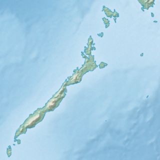
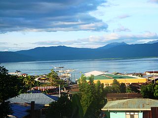
Pujada Bay, sometimes called Pujaga Bay, is a bay on the Pacific coast of the southern Philippine island of Mindanao. It is an arm of the Philippine Sea in Davao Oriental province formed by the Guanguan Peninsula which separates it from the Mayo Bay on the east and the Pujada Peninsula which separates it from the Davao Gulf on the west. Pujada Bay borders Mati, the province's capital and largest city, with its port and city proper situated at its head. It is entered between Lamigan Point on the east and Tumago Point on the west, with the Pujada Island dividing its entrance into two channels. There are three other islands on the bay, namely Uanivan, Oak and Ivy islands.

Murcielagos Island is a small island in the Sulu Sea off the coast of Zamboanga del Norte in the southern Philippine island of Mindanao. It measures over 500 metres (1,600 ft) across at its widest point and is situated on an oval reef about 1.6 kilometres (0.99 mi) in length. This low-lying island, also known locally as Baliudyong, is situated some 4.8 kilometres (3.0 mi) north of Quipit Point on the west side of Patauag Bay in the Zamboanga municipality of Labason. It is known for its white coral-sand beaches and rich marine resources. To its west lies an islet called Bayangan Island. The two islands are collectively known as Murcielagos Islands and are administratively part of the Labason poblacion of Antonino.

Selinog, historically known as Silino and also named Silinog, is an island barangay in Dapitan, Zamboanga del Norte, Philippines. It is coterminous with Silino Island and is located 12.9 kilometres (8.0 mi) off Tagolo Point, the northern entrance point to Dapitan Bay, and some 15 kilometres (9.3 mi) east of the island of Aliguay in the Bohol Sea. The island is a flat coralline island with a land area of 78 hectares. It is surrounded by 70 hectares of coral reefs and sandy areas. According to the 2010 census, the island community has a population of 712 inhabitants.
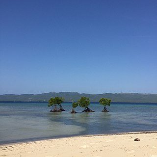
Rasa Island is a flat coral island in the Sulu Sea just off the coast of the municipality of Narra in Palawan, Philippines. It is a shallow island surrounded by mangroves and tidal flats containing one of the country's last remaining coastal forests. The island is home to the largest population of the endemic and critically endangered Philippine cockatoo in the wild in the Philippines. It was declared a protected area in 2006.
Dumanquilas Bay is an arm of the Moro Gulf on the southern side of the Zamboanga Peninsula in western Mindanao island in the Philippines. It is shared between the provinces of Zamboanga del Sur on the eastern and northern shore, and Zamboanga Sibugay on the western shore. An irregularly shaped peninsula extending to Flecha Point separates it from Pagadian Bay to the east, while to the west, the bay connects with Sibuguey Bay through Canalizo Strait which separates Olutanga island from the mainland of Zamboanga. Politically, it is divided between the Zamboanga del Sur municipalities of Margosatubig, Vincenzo Sagun, Lapuyan and Kumalarang, and the Zamboangay Sibugay municipalities of Buug, Malangas and Alicia.
Malampaya Sound is a protected inlet of the South China Sea on the northwestern coast of Palawan Island in western Philippines. It is a geographic sound consisting of a complex of sheltered bays, coves, estuaries and islands separated from the sea to the west by the Copoas Peninsula. The sound is within the municipality of Taytay and is an important feature for the ecology and economy of the province of Palawan. It is considered one of the finest natural harbors in the Philippines and one of Palawan's richest fishing grounds.
Alibijaban is a small island located off the southeastern coast of Bondoc Peninsula in the Philippines. It belongs administratively to the municipality of San Andres, Quezon province, and is coterminous with the barangay of the same name. With a population of 1,643 inhabitants in 2015, it is the smallest of seven barangays in San Andres.
The Mabini Protected Landscape and Seascape, in Davao de Oro, Philippines, is a terrestrial and marine protected area established in 2000 to protect ecologically significant habitats in the Davao Gulf. The park extends along the coast of the municipality of Mabini from the mouth of the Pandasan River to the southern tip of Kopiat Island. It also includes Lunod Island, also known as Pandasan Island, which was earlier declared a wilderness area in 1981. It covers 6,106 hectares of extensive mangrove forests, white sand beaches and rich coral reef systems.
The Biri Larosa Protected Landscape and Seascape is a protected area located in Northern Samar, Philippines, about 40 kilometres (25 mi) west of Catarman. It protects the Balicuatro Islands, composed of the island municipality of Biri and associated smaller islands, off the northwestern coast of Samar in the San Bernardino Strait. It also includes the coastal areas of the adjacent municipalities from which it derives the second half of its name – a combination of the first two letters of Lavezares, Rosario and San Jose.
The Guiuan Protected Landscape and Seascape, also known as the Guiuan Marine Reserve, is a protected area associated with the Guiuan Island Group which is located off the coast of the municipality of Guiuan on the eastern side of Leyte Gulf in the Philippines. The protected area consists of the following islands from within the group: Calicoan, Manicani, Suluan, Tubabao, Victory, Homonhon and other smaller islands and their surrounding reefs. It also includes the coastal area of mainland Guiuan in Eastern Samar covering a total area of 60,448 hectares. The land which now comprises the conservation area was previously declared as a Marine Reserve and Tourist Zone and was placed under the administration and control of the Philippine Tourism Authority in 1978. It was re-proclaimed and re-classified as a protected landscape/seascape in 1994 under the National Integrated Protected Areas System Act of 1992.

Camarines Sur's 4th congressional district is one of the five congressional districts of the Philippines in the province of Camarines Sur. It has been represented in the House of Representatives since 1987. The district consists of municipalities in the Partido region of eastern Camarines Sur, namely Caramoan, Garchitorena, Goa, Lagonoy, Presentacion, Sagñay, San Jose, Siruma, Tigaon and Tinambac. It is currently represented in the 18th Congress by Arnulf Bryan Fuentebella of the Nationalist People's Coalition (NPC).
