
The Bicol Region, designated as Region V, is an administrative region of the Philippines. It comprises six provinces, four on the Bicol Peninsula : Albay, Camarines Norte, Camarines Sur, and Sorsogon, and two off the shore: Catanduanes and Masbate.

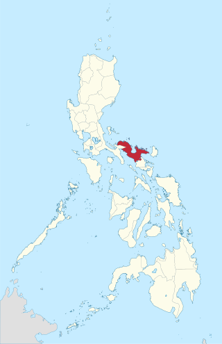
Camarines Sur, officially the Province of Camarines Sur, is a province in the Philippines located in the Bicol Region on Luzon. Its capital is Pili and the province borders Camarines Norte and Quezon to the northwest, and Albay to the south. To the east lies the island province of Catanduanes across the Maqueda Channel.

Camarines Norte, officially the Province of Camarines Norte, is a province in the Philippines located in the Bicol Region in Luzon. Its capital is Daet, the most populous town in the province. The province borders Quezon to the west, Camarines Sur to the south, and the Philippine Sea to the north. It has historically been a Bikol-speaking region. However, there has been a language shift in recent years to Tagalog, which is more commonly used nowadays.

Basud, officially the Municipality of Basud, is a municipality in the province of Camarines Norte, Philippines. According to the 2020 census, it has a population of 45,133 people.

Daet, officially the Municipality of Daet, is a municipality and capital of the province of Camarines Norte, Philippines. According to the 2020 census, it has a population of 111,700 people making it the most populous in the province.

Labo, officially the Municipality of Labo, is a municipality in the province of Camarines Norte, Philippines. According to the 2020 census, it has a population of 109,245 people.

Lupi, officially the Municipality of Lupi, is a municipality in the province of Camarines Sur, Philippines. According to the 2020 census, it has a population of 33,897 people.

Pasacao, officially the Municipality of Pasacao, is a 1st class municipality in the province of Camarines Sur, Philippines. According to the 2020 census, it has a population of 53,461 people. The area is noted for its brown sand beaches and is sometimes referred to as the "Summer Capital of Camarines Sur.
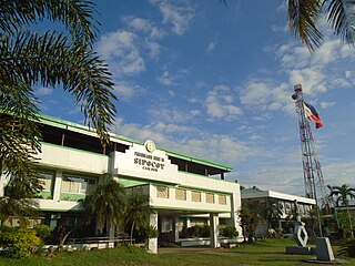
Sipocot, officially the Municipality of Sipocot, is a 1st class municipality in the province of Camarines Sur, Philippines. According to the 2020 census, it has a population of 68,169 people.

The Metropolitan Archdiocese of Nueva Cáceres is a Latin Church archdiocese of the Catholic Church in the Philippines. It is a metropolitan see that comprises the Bicol Region, while directly overseeing the third, fourth, and fifth congressional districts of Camarines Sur, Naga City, Iriga City and the Municipality of Gainza. The archdiocese, having been founded in 1595 in Nueva Cáceres, is also considered one of the oldest dioceses in the Philippines with Cebu, Segovia and Manila, and once had jurisdiction that stretched from Samar in the south and Isabela Province in the north. The seat of the archdiocese is currently located in Naga City, also known as the Queen City of Bicol.
Ambos Camarines, officially the Province of Ambos Camarines, was a historical province in the Philippines found on the northern end of the Bicol Peninsula. It now exists as two separate provinces—Camarines Norte (North) and Camarines Sur (South).

The Pan-Philippine Highway, also known as the Maharlika Highway, is a network of roads, expressways, bridges, and ferry services that connect the islands of Luzon, Samar, Leyte, and Mindanao in the Philippines, serving as the country's principal transport backbone. Measuring 3,379.73 kilometers (2,100.07 mi) long excluding sea routes not counted by highway milestones, it is the longest road in the Philippines that forms the country's north–south backbone component of National Route 1 (N1) of the Philippine highway network. The entire highway is designated as Asian Highway 26 (AH26) of the Asian Highway Network.
The legislative districts of Ambos Camarines were the representations of the historical province of Ambos Camarines in the various national legislatures of the Philippines until 1919.
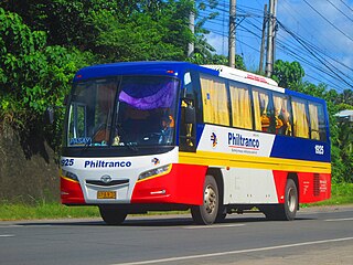
Philtranco Service Enterprises, Inc. is a bus company in the Philippines, servicing routes to Bicol, Eastern Visayas, Caraga, Davao Region, and Northern Mindanao. It is the oldest bus operator in the Philippines and in Asia. It is also the only bus carrier with a nationwide public transport franchise. Philtranco currently has more than 250 buses for its operations.

Rolando Andaya Highway, officially known as Quirino Highway and also known as Camarines Sur–Quezon Road, is a national primary highway located in the provinces of Camarines Norte, Quezon, and Camarines Sur in the Philippines. It serves as an alternative route to the Pan-Philippine Highway and has been efficiently used as a major highway since the 1990s. It traverses the municipality of Santa Elena in Camarines Norte, municipalities of Sipocot, Lupi, Ragay, and Del Gallego in Camarines Sur, and the municipalities of Tagkawayan, Guinayangan, and Calauag in Quezon. It is primarily known as Andaya Highway in segments within Camarines Sur and likewise called as Quirino Highway within Camarines Norte and Quezon.

The Japanese Invasion of Legazpi on 12 December 1941 was one in a series of advance landings made by Imperial Japanese forces as first step in their invasion of the Philippines. The purpose was to obtain control of local air strips, which could be used as forward bases by fighter aircraft for operations in central Luzon. Control of Legazpi was an important point in the Japanese strategy, as it would also give them control of San Bernardino Strait, between the islands Luzon and Samar, which would prevent the Americans from bringing in reinforcements from the south. The first invasion was at Batan Island on 8 December 1941. This was followed by Vigan, Aparri, Legazpi, Davao, and Jolo Island over the next few days

The Magapit Protected Landscape is a protected area of forested limestone hills and grasslands in the Cagayan Valley of northern Luzon island in the Philippines. It covers an area of 3,403.62 hectares in northeastern Cagayan province straddling the municipalities of Lal-lo and Gattaran. The park was established as a game refuge and bird sanctuary on 15 August 1947 covering an initial area of 4,554 hectares declared through Administrative Order No. 10 by President Manuel Roxas. On 23 April 2000, the park was redesignated as a protected landscape area under the National Integrated Protected Areas System Act through Proclamation No. 285 signed by President Joseph Estrada. The park is a component of the Northeastern Cagayan Key Biodiversity Area and also contains the Lal-lo and Gattaran Shell Middens, a proposed World Heritage Site.
The Mainit Hot Springs Protected Landscape is a protected landscape area located in the province of Davao de Oro on the island of Mindanao in the Philippines. It preserves the sulfuric hot springs and surrounding forest in Nabunturan municipality which also contains the headwaters of the Manat River, a source of water supply for surrounding villages. First declared a national park in 1957 by virtue of Proclamation No. 466 by President Carlos P. Garcia, it had an initial area of 1,381 hectares. Under the National Integrated Protected Areas System, it was reclassified as a protected landscape through Proclamation No. 320 issued in 2000 by President Joseph Estrada. The hot springs are a popular ecotourist attraction in Davao de Oro. Its name "Mainit" is a Filipino word which means hot.
The Maulawin Spring Protected Landscape is a protected landscape area of forested hills and several rivers and streams located in the province of Quezon on southern Luzon island in the Philippines. It was originally created in 1939 to protect the watershed in the municipality of Guinayangan known as the Maulawin Spring Watershed Forest Reserve declared through Proclamation No. 365 by President Manuel Luis Quezon. It had an initial area of 60 hectares. In 2000, the forest reserve was enlarged and was redesignated as a protected landscape under the National Integrated Protected Areas System by virtue of Proclamation No. 295 issued by President Joseph Estrada. It is the only source of potable water for domestic consumption of the more than 40,000 residents of Guinayangan.

The Quezon Protected Landscape is a protected area in the Republic of the Philippines, spanning the municipalities of Pagbilao, Padre Burgos and Atimonan in Quezon province. The park is situated north of the narrowest section of Luzon in Quezon province, located about 164 km (102 mi) southeast of Metro Manila.


