Caramoan

Last updated
Caramoan
Municipality of Caramoan
Caramoan town.jpg
Caramoan town proper
Flag of Caramoan, Camarines Sur.png
Ph locator camarines sur caramoan.png
Map of Camarines Sur with Caramoan highlighted
OpenStreetMap
Caramoan
Philippines location map (square).svg
Red pog.svg
Caramoan
Location within the Philippines
Coordinates: 13°46′15″N123°51′47″E / 13.7707°N 123.8631°E / 13.7707; 123.8631
CountryPhilippines
Region Bicol Region
Province Camarines Sur
District 4th district
Founded 1945
Barangays 49 (see Barangays)
Government
[1]
  Type Sangguniang Bayan
   Mayor Marilyn Socorro H. Co [2]
   Vice Mayor Dyan S. Ramirez [3]
   Representative Arnulf Bryan B. Fuentebella
   SB Members
  • Edvir G. Palaya
  • Honesto C. Obias II
  • Jeffrey F. Sancho
  • Francis R. Benemerito
  • John H. Camacho
  • Juan C. Cordis III
  • Elvis C. Alarkon
  • Gabrielle A. Padua
   Electorate 34,357 voters (2022)
Area
[4]
  Total276.00 km2 (106.56 sq mi)
Elevation
[5]
14.1 m (46.3 ft)
Highest elevation
1,006 m (3,301 ft)
Lowest elevation
0 m (0 ft)
Population
 (2020 census) [6]
  Total51,728
  Density190/km2 (490/sq mi)
   Households
11,570
Economy
   Income class 2nd municipal income class
   Poverty incidence
25.32
% (2018) [7]
   Revenue 196.5 million (2020)
   Assets 373.9 million (2020)
   Expenditure 148.3 million (2020)
   Liabilities 43.66 million (2020)
Service provider
  ElectricityCamarines Sur 4 Electric Cooperative (CASURECO 4)
Time zone UTC+8 (PST)
ZIP code
4429
PSGC
IDD : area code +63(0)54
Native languages Central Bikol
Tagalog

Caramoan, officially the Municipality of Caramoan (Central Bikol : Banwaan kan Caramoan; Tagalog : Bayan ng Caramoan), is a 2nd class municipality in the province of Camarines Sur, Philippines. According to the 2020 census, it has a population of 51,728 people. [6]

Contents

The municipality is located at the tip of the Caramoan Peninsula, a rugged place of land extending into the waters of the Maqueda Channel on the north and east and Lagonoy Gulf on the south. It has been dubbed as the Emerging Paradise of the Pacific due to its white and pink sand beaches known internationally.

History

St. Michael the Archangel Parish Church St. Michael Parish Church of Caramoan.jpg
St. Michael the Archangel Parish Church

The name Caramoan has been officially used since 1619, the year it was named by a Spanish missionary friar, Francisco de la Cruz Y Oropesa. Fr. Oropesa penetrated the thick virgin forest of the Caramoan Peninsula and founded a small settlement in a place called Baluarte. This settlement was subsequently turned over to the administration of the Holy Bishopric in 1696.

Prior to the arrival of the Spaniards, it was determined that the place was once called Guta de Leche, which was given by Dutch traders who operated a gold mine in Lahuy Island and who frequented the area to trade with the natives. The name was perhaps derived from the milkdrop stalagmites found among the rocks of Guta Port. Upon the arrival of the Spaniards, the place came to be called "Carahan" for the sea turtle, which was at that time to be found in great number along the shores of the Peninsula.

Geography

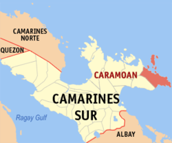
Caramoan is bounded on the north by the town of Garchitorena formerly town of Caramoan and the Philippine Sea of the Pacific Ocean; on the north-east by the island province of Catanduanes; on the south by Lagonoy Gulf; on the east by the Maqueda Channel and on the west by the municipality of Presentacion.

The municipality covers approximately 277.41 square kilometres (107.11 sq mi) with approximately 71 kilometres (44 mi) of irregular coastline surrounded by the vast ocean, bay, seas and swamps. It is approximately 500 kilometres (310 mi) from Metro Manila; 95 kilometres (59 mi) from the municipality of Pili, where the seat of the provincial government and the Naga Domestic Airport are located; and 110 kilometres (68 mi) east from Naga City, the heart of Bicol.

Caramoan Islands

Off the coast of the peninsula are numerous small islets. The 10 principal islands of the group are: [8]

  • Bag-ing
  • Cagbanilad
  • Catanhawan
  • Cotivas
  • Lahos
  • Lahuy
  • Matukad
  • Minalahos
  • Pitogo
  • Sabitang-Laya
Matukad Island Aerial View.jpg
Matukad Island

Barangays

Caramoan is politically subdivided into 49 barangays. Each barangay consists of puroks and some have sitios.

  • Agaas
  • Antolon
  • Bacgong
  • Bahay
  • Bikal
  • Binanuahan
  • Cabacongan
  • Cadong
  • Colongcogong
  • Canatuan
  • Caputatan
  • Gogon
  • Daraga
  • Gata
  • Gibgos
  • Guijalo
  • Hanopol
  • Hanoy
  • Haponan
  • Ilawod
  • Ili-Centro
  • Lidong
  • Lubas
  • Malabog
  • Maligaya
  • Mampirao
  • Mandiclum
  • Maqueda
  • Minalaba
  • Oring
  • Oroc-Osoc
  • Pagolinan
  • Pandanan
  • Paniman
  • Patag-Belen
  • Pili-Centro
  • Pili-Tabiguian
  • Poloan
  • Salvacion
  • San Roque
  • San Vicente
  • Santa Cruz
  • Solnopan (Poblacion)
  • Tabgon
  • Tabiguian
  • Tabog
  • Tawog
  • Toboan
  • Terogo

Climate

Climate data for Caramoan, Camarines Sur
MonthJanFebMarAprMayJunJulAugSepOctNovDecYear
Mean daily maximum °C (°F)30
(86)
30
(86)
32
(90)
35
(95)
35
(95)
35
(95)
34
(93)
35
(95)
33
(91)
31
(88)
31
(88)
29
(84)
33
(91)
Mean daily minimum °C (°F)27
(81)
27
(81)
28
(82)
31
(88)
31
(88)
31
(88)
30
(86)
30
(86)
29
(84)
28
(82)
28
(82)
26
(79)
29
(84)
Average precipitation mm (inches)151.1
(5.95)
198.89
(7.83)
106.28
(4.18)
60.08
(2.37)
63.62
(2.50)
85.76
(3.38)
117.53
(4.63)
46.99
(1.85)
52.23
(2.06)
740.22
(29.14)
522.70
(20.58)
618
(24.3)
2,763.4
(108.77)
Average rainy days242818232325292126282931305
Source: World Weather Online (modeled/calculated data, not measured locally) [9]

Demographics

Caramoan Municipal Hall Caramoan Municipal Hall.jpg
Caramoan Municipal Hall
Population census of Caramoan
YearPop.±% p.a.
1948 26,836    
1960 27,160+0.10%
1970 31,339+1.44%
1975 31,399+0.04%
1980 32,659+0.79%
1990 36,107+1.01%
YearPop.±% p.a.
1995 39,416+1.66%
2000 39,642+0.12%
2007 40,810+0.40%
2010 44,945+3.57%
2015 47,605+1.10%
2020 51,728+1.65%
Source: Philippine Statistics Authority [10] [11] [12] [13]

In the 2020 census, the population of Caramoan was 51,728 people, [6] with a density of 190 inhabitants per square kilometre or 490 inhabitants per square mile.

Economy

Tourism

Sabitang-Laya Matukad Island Sabitang-Laya Caramoan - panoramio.jpg
Sabitang-Laya Matukad Island

Tourist destinations include the Caramoan National Park, the Centro, and Gota Beach, where activities include diving, swimming, snorkeling and spelunking.

Survivor series

Caramoan has been the site for several editions of the competitive reality television show Survivor . The area has hosted the U.S. version in two consecutive seasons ( Survivor: Philippines and Survivor: Caramoan ), the Serbian version for two consecutive seasons and the Israeli version for three consecutive seasons (** Survivor: The Philippines , Survivor: Fans vs. Survivors , Survivor: Camarines ). Bulgarian Survivor also filmed its fourth season there in May to July 2009.[ citation needed ] Robinson 2010 , the 12th season of the Swedish version of the franchise, was filmed in Caramoan from May to June 2010. Finnish versions were filmed in there in 2018 with all-celebrity cast, and in 2019 half-famous and half- regular people cast.

The 8th season of Koh-Lanta , the French edition of Survivor, also was shot there. TV director Corinne Vaillant stated that "the powdery sand, the coconuts on Gota beach and the neighboring islets are a 'dream' for the French people. We chose Caramoan because it’s really wild. It’s necessary that contestants don’t see anything other than nature for them to believe that they’re really lost in the wilds.” [21]

The only season of Survivor India was shot in Caramoan, with an Indian production crew spotted in the area in March 2011. [22]

The first season of Supraviețuitorul , a Romanian reality game based on Survivor was shot in Caramoan in the summer of 2016, as well as the first and second season of Robinsonův ostrov (Czech version).

In spring of 2016 the first season of the Slovenian version of Survivor Philippines was filmed on 4 different islands, including Catanaguan and Tayak.

Related Research Articles

<span class="mw-page-title-main">Camarines Sur</span> Province in Bicol, Philippines

Camarines Sur, officially the Province of Camarines Sur, is a province in the Philippines located in the Bicol Region on Luzon. Its capital is Pili and the province borders Camarines Norte and Quezon to the northwest, and Albay to the south. To the east lies the island province of Catanduanes across the Maqueda Channel.

<span class="mw-page-title-main">Labo, Camarines Norte</span> Municipality in Camarines Norte, Philippines

Labo, officially the Municipality of Labo, is a 1st class municipality in the province of Camarines Norte, Philippines. According to the 2020 census, it has a population of 109,245 people.

<span class="mw-page-title-main">Mercedes, Camarines Norte</span> Municipality in Camarines Norte, Philippines

Mercedes, officially the Municipality of Mercedes, is a 2nd class municipality in the province of Camarines Norte, Philippines. According to the 2020 census, it has a population of 55,334 people.

<span class="mw-page-title-main">Santa Elena, Camarines Norte</span> Municipality in Camarines Norte, Philippines

Santa Elena, officially the Municipality of Santa Elena, is a 3rd class municipality in the province of Camarines Norte, Philippines. According to the 2020 census, it has a population of 43,582 people.

<span class="mw-page-title-main">Caramoran</span> Municipality in Catanduanes, Philippines

Caramoran, officially the Municipality of Caramoran, is a 3rd class municipality in the province of Catanduanes, Philippines. According to the 2020 census, it has a population of 32,114 people.

<span class="mw-page-title-main">Baao</span> Municipality in Camarines Sur, Philippines

Baao, officially the Municipality of Baao is 1st class municipality in the province of Camarines Sur, Philippines. According to the 2020 census, it has a population of 61,493 people.

<span class="mw-page-title-main">Bula, Camarines Sur</span> Municipality in Camarines Sur, Philippines

Bula, officially the Municipality of Bula, is a 1st class municipality in the province of Camarines Sur, Philippines. According to the 2020 census, it had a population of 73,143 people.

<span class="mw-page-title-main">Del Gallego</span> Municipality in Camarines Sur, Philippines

Del Gallego, officially the Municipality of Del Gallego, is a 4th class municipality in the province of Camarines Sur, Philippines. According to the 2020 census, it has a population of 26,403 people.

<span class="mw-page-title-main">Garchitorena</span> Municipality in Camarines Sur, Philippines

Garchitorena, officially the Municipality of Garchitorena, is a 4th class municipality in the province of Camarines Sur, Philippines. According to the 2020 census, it has a population of 29,436 people.

<span class="mw-page-title-main">Goa, Camarines Sur</span> Municipality in Camarines Sur, Philippines

Goa, officially the Municipality of Goa, is a 1st class municipality in the province of Camarines Sur, Philippines. According to the 2020 census, it has a population of 71,368 people.

<span class="mw-page-title-main">Lagonoy</span> Municipality in Camarines Sur, Philippines

Lagonoy, officially the Municipality of Lagonoy, is a 2nd class municipality in the province of Camarines Sur, Philippines. According to the 2020 census, it has a population of 56,714 people.

<span class="mw-page-title-main">Lupi, Camarines Sur</span> Municipality in Camarines Sur, Philippines

Lupi, officially the Municipality of Lupi, is a 3rd class municipality in the province of Camarines Sur, Philippines. According to the 2020 census, it has a population of 33,897 people.

<span class="mw-page-title-main">Minalabac</span> Municipality in Camarines Sur, Philippines

Minalabac, officially the Municipality of Minalabac, is a 2nd class municipality in the province of Camarines Sur, Philippines. According to the 2020 census, it has a population of 53,981 people.

<span class="mw-page-title-main">Ocampo, Camarines Sur</span> Municipality in Camarines Sur, Philippines

Ocampo, officially the Municipality of Ocampo, is a 1st class municipality in the province of Camarines Sur, Philippines. According to the 2020 census, it has a population of 51,073 people.

<span class="mw-page-title-main">Pili, Camarines Sur</span> Capital of Camarines Sur, Philippines

Pili, officially the Municipality of Pili is a 1st class municipality and capital of the province of Camarines Sur, Philippines. According to the 2020 census, it has a population of 99,196 people.

<span class="mw-page-title-main">Presentacion</span> Municipality in Camarines Sur, Philippines

Presentacion, officially the Municipality of Presentacion, is a 4th class municipality in the province of Camarines Sur, Philippines. According to the 2020 census, it has a population of 22,591 people.

<span class="mw-page-title-main">Ragay</span> Municipality in Camarines Sur, Philippines

Ragay, officially the Municipality of Ragay, is a 1st class municipality in the province of Camarines Sur, Philippines. According to the 2020 census, it has a population of 59,770 people.

<span class="mw-page-title-main">Sagñay</span> Municipality in Camarines Sur, Philippines

Sagñay,, officially the Municipality of Sagñay, is a 4th class municipality in the province of Camarines Sur in the Philippines. According to the 2020 census, it has a population of 36,841 people.

<span class="mw-page-title-main">San Fernando, Camarines Sur</span> Municipality in Camarines Sur, Philippines

San Fernando, officially the Municipality of San Fernando, is a 2nd class municipality in the province of Camarines Sur, Philippines. According to the 2020 census, it has a population of 38,626 people.

<span class="mw-page-title-main">Siruma</span> Municipality in Camarines Sur, Philippines

Siruma, officially the Municipality of Siruma, is a 4th class municipality in the province of Camarines Sur, Philippines. According to the 2020 census, it has a population of 19,419 people.

References

  1. Municipality of Caramoan | (DILG)
  2. "LGU Directory - Caramoan". Local Government Academy.
  3. "LGU Directory - Caramoan". Local Government Academy.
  4. "2015 Census of Population, Report No. 3 – Population, Land Area, and Population Density" (PDF). Philippine Statistics Authority. Quezon City, Philippines. August 2016. ISSN   0117-1453. Archived (PDF) from the original on May 25, 2021. Retrieved July 16, 2021.
  5. Error: Unable to display the reference properly. See the documentation for details.
  6. 1 2 3 Census of Population (2020). "Region V (Bicol Region)". Total Population by Province, City, Municipality and Barangay. Philippine Statistics Authority . Retrieved 8 July 2021.
  7. "PSA Releases the 2018 Municipal and City Level Poverty Estimates". Philippine Statistics Authority. 15 December 2021. Retrieved 22 January 2022.
  8. "Caramoan Islands". CaramoanIslands.com. Retrieved February 10, 2013.
  9. "Caramoan, Camarines Sur: Average Temperatures and Rainfall". World Weather Online. Retrieved 29 October 2017.
  10. Census of Population (2015). "Region V (Bicol Region)". Total Population by Province, City, Municipality and Barangay. Philippine Statistics Authority . Retrieved 20 June 2016.
  11. Census of Population and Housing (2010). "Region V (Bicol Region)" (PDF). Total Population by Province, City, Municipality and Barangay. National Statistics Office . Retrieved 29 June 2016.
  12. Censuses of Population (1903–2007). "Region V (Bicol Region)". Table 1. Population Enumerated in Various Censuses by Province/Highly Urbanized City: 1903 to 2007. National Statistics Office.{{cite encyclopedia}}: CS1 maint: numeric names: authors list (link)
  13. "Province of Camarines Sur". Municipality Population Data. Local Water Utilities Administration Research Division. Retrieved 17 December 2016.
  14. "Poverty incidence (PI):". Philippine Statistics Authority. Retrieved December 28, 2020.
  15. "Estimation of Local Poverty in the Philippines" (PDF). Philippine Statistics Authority. 29 November 2005.
  16. "2003 City and Municipal Level Poverty Estimates" (PDF). Philippine Statistics Authority. 23 March 2009.
  17. "City and Municipal Level Poverty Estimates; 2006 and 2009" (PDF). Philippine Statistics Authority. 3 August 2012.
  18. "2012 Municipal and City Level Poverty Estimates" (PDF). Philippine Statistics Authority. 31 May 2016.
  19. "Municipal and City Level Small Area Poverty Estimates; 2009, 2012 and 2015". Philippine Statistics Authority. 10 July 2019.
  20. "PSA Releases the 2018 Municipal and City Level Poverty Estimates". Philippine Statistics Authority. 15 December 2021. Retrieved 22 January 2022.
  21. Aguilar, Ephraim (May 8, 2008). "4th-class town well on the way to celeb status". Philippine Daily Inquirer. Archived from the original on February 12, 2012. Retrieved May 20, 2012.
  22. Talagtag, Jr., Anselmo (October 30, 2011). "How Caramoan wowed "Survivor India"". Manila Bulletin. Archived from the original on November 14, 2011. Retrieved September 15, 2012.