
Albay, officially the Province of Albay, is a province in the Bicol Region of the Philippines, mostly on the southeastern part of the island of Luzon. Its capital is the city of Legazpi, the regional center of the whole Bicol Region, which is located in the southern foothill of Mayon Volcano.

Sorsogon, officially the Province of Sorsogon, is a province in the Philippines located in the Bicol Region. It is the southernmost province in Luzon and is subdivided into fourteen municipalities (towns) and one city. Its capital is Sorsogon City and borders the province of Albay to the north.
Masbate, officially the Province of Masbate, is an island province in the Philippines located near the midsection of the nation's archipelago. Its provincial capital is Masbate City. The province consists of three major islands: Masbate, Ticao and Burias.
Ticao Island, is an island with a total land area of 334 km2 or 129 sq mi. It is one of the three major islands of Masbate province in the Philippines. It is separated from the Bicol Peninsula by the Ticao Pass. The other two major islands are Masbate Island and Burias Island.

Masbate Island is the largest of three major islands of Masbate Province in the Philippines. The other two major islands are Ticao Island and Burias Island. It is the 11th-largest island in both area and population in the Philippines and the world's 155th largest island by area and the world's 70th most populous island. The island is divided into 14 municipalities and 1 city, and has a total population of 731,269 people as of 2020 census. Masbate City is the island largest settlement with a total population of 104,522 as of 2020.
Burias Island is one of the three major islands of Masbate province in the Philippines. It is separated from the Bicol Peninsula by the Burias Pass. The other two major islands are Ticao Island and Masbate Island. The Island has two municipalities, Claveria and San Pascual.
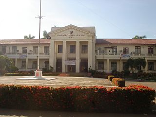
Masbate City, officially known as the City of Masbate, is a 4th class component city and capital of the province of Masbate, Philippines. According to the 2020 census, it has a population of 104,522 people.

Aroroy, officially the Municipality of Aroroy, is a 1st class municipality in the province of Masbate, Philippines. According to the 2020 census, it has a population of 88,351 people. The town is known for the Kalanay Cave, one of the most important archaeological sites in Masbate province.

Batuan, officially the Municipality of Batuan, is a 5th class municipality in the province of Masbate, Philippines. According to the 2020 census, it has a population of 14,610 people.

Monreal, officially the Municipality of Monreal, is a 4th class municipality in the province of Masbate, Philippines. According to the 2020 census, it has a population of 25,164 people.

San Fernando, officially the Municipality of San Fernando, is a 5th class municipality in the province of Masbate, Philippines. According to the 2020 census, it has a population of 21,600 people.

San Jacinto, officially the Municipality of San Jacinto, is a 4th class municipality in the province of Masbate, Philippines. According to the 2020 census, it has a population of 29,686 people.

The Samar Sea is a small sea within the Philippine archipelago, situated between the Bicol Region of Luzon and the Eastern Visayas.
Bugui Point Lighthouse is a historic lighthouse located on Bugui Point in the town of Aroroy, in the northern tip of Masbate Island, province of Masbate, in the Philippines. It lights the entrance to the channel between Burias Island and Masbate Island and the channel between Burias and Ticao Islands leading to San Bernardino Strait.
Bongsanglay Natural Park is a protected area of mangrove forests and swamps on Ticao Island in the Bicol Region of the Philippines. It is located in the municipality of Batuan in the island province of Masbate covering an area of 244.72 hectares. The protected area was established on 29 December 1981 when the area "from Panciscan Point in Bitos Bay up to Bano Sanlay" in Batuan was declared a Mangrove Swamp Forest Reserve under Proclamation No. 2152 signed by President Ferdinand Marcos. In 2000, when President Joseph Estrada signed Proclamation No. 319, Bongsanglay was reclassified as a natural park pursuant to the National Integrated Protected Areas System (NIPAS) Act.

The Bikol languages or Bicolano languages are a group of Central Philippine languages spoken mostly in the Bicol Peninsula in the island of Luzon, the neighboring island province of Catanduanes and the island of Burias in Masbate.

Burias Pass is the strait that separates Burias Island from the Bicol Peninsula in the Philippines. It connects the Ragay Gulf in the north with the Ticao Pass and Samar Sea in the south. It is considered a very important biodiversity area of the country.
Masbate's at-large congressional district refers to the lone congressional district of the Philippines in the province of Masbate for various national legislatures before 1987. The province had its representatives elected or appointed province-wide at-large from its reorganization under Article 6 of the Decreto de 18 junio de 1898 y las instrucciones sobre el régimen de las provincias y pueblos for the Malolos Congress in 1898 until the creation of a first, second and third district on February 2, 1987. It was represented as a single-member district when it was re-established as a regular province separate from Sorsogon in 1920 and took part in five legislatures of the Insular Government of the Philippine Islands from 1922 to 1935, the three legislatures of the Philippine Commonwealth from 1935 to 1946, and the seven congresses of the Third Philippine Republic from 1946 to 1972.

Masbate's 1st congressional district is one of the three congressional districts of the Philippines in the province of Masbate. It has been represented in the House of Representatives since 1987. The district consists of six municipalities in the Burias and Ticao islands of northern Masbate, namely Claveria and San Pascual in Burias island, and Batuan, Monreal, San Fernando and San Jacinto in Ticao island. It is currently represented in the 18th Congress by Narciso Bravo Jr. of the National Unity Party (NUP).


