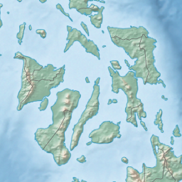
The Visayas, or the Visayan Islands, are one of the three principal geographical divisions of the Philippines, along with Luzon and Mindanao. Located in the central part of the archipelago, it consists of several islands, primarily surrounding the Visayan Sea, although the Visayas are also considered the northeast extremity of the entire Sulu Sea. Its inhabitants are predominantly the Visayan peoples.

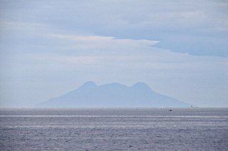
Siquijor, officially the Province of Siquijor, is an island province in the Philippines located in the Central Visayas region. Its capital is the municipality also named Siquijor. To the north of Siquijor is Cebu, to the west is Negros, northeast is Bohol, and to the south, across the Bohol Sea, is Mindanao.

Cebu Strait is a strait in the Central Visayas region in the Philippines.
The Bohol Sea, also called the Mindanao Sea, is a sea located between the Visayas and Mindanao islands in the Philippines. It lies south of Bohol and Leyte and north of Mindanao. Siquijor and Camiguin are its two major islands.

The Visayan Sea is a sea in the Philippines surrounded by the islands of the Visayas. It is bounded by the islands Masbate to the north, Panay to the west, Leyte to the east, and Cebu and Negros to the south.
Camotes Islands is a group of islands in the Camotes Sea, Philippines. Combined area is 236.36 kilometres (146.87 mi). The island group is located east of Cebu Island, southwest of Leyte Island, and north of Bohol Island. It is 34 nautical miles from Cebu City and is part of Cebu. According to the 2015 census, it has a population of 102,996. Population has grown 34.3% since 1990, equivalent to an annual growth rate of 1.19%.

Daanbantayan, officially the Municipality of Daanbantayan, is a 1st class municipality in the province of Cebu, Philippines. According to the 2020 census, it has a population of 93,502 people.

Poro, officially the Municipality of Poro, is a 4th class municipality in the province of Cebu, Philippines. According to the 2020 census, it has a population of 26,232 people.

Talibon, officially the Municipality of Talibon, is a 1st class municipality in the province of Bohol, Philippines. According to the 2020 census, it has a population of 71,272 people.

The Camotes Sea is a small sea within the Philippine archipelago, situated between the Central Visayan and the Eastern Visayan regions. It separates Cebu from Leyte hence is bordered by Cebu to the west, Leyte to the east and north, and Bohol to the south. At its center are the Camotes Islands, but it also contains Mactan Island, Olango Island, Lapinig Island, and various other small islets.
Hilutangan Channel is a deep water channel that separates Mactan Island from Olango Island.

The Olango Island Group is a group of islands found in the Central Visayas region of the Philippines. It comprises Olango island and 6 satellite islets namely: Caubian, Camungi, Caohagan, Gilutongan, Nalusuan, Pangan-an, and Sulpa. The island group has a total land area of approximately 1,030 hectares. It is divided under the jurisdiction of the city of Lapu-Lapu and the municipality of Cordova, Cebu. It lies 5 kilometers (3.1 mi) east of Mactan and is a major tourist destination in Cebu. It is known for its wildlife sanctuary. The entire area is the first declared Ramsar Wetland Site in the Philippines, as recognized in 1994.
The Mactan Channel, also known as Opon Channel, is the strait between the island of Cebu and the smaller Mactan Island. The body of water is located within Metro Cebu, separating Mandaue and Cebu City in mainland Cebu from Lapu-Lapu City on Mactan. It is one of the three channels that connect the Cebu Strait to the Camotes Sea — the other two being the Hilutangan Channel and the Olango Channel.
The Tañon Strait is a body of water, separating the islands of Negros and Cebu in the Visayas, Philippines. The strait, which is about 160 kilometres (100 mi) long, connects the Visayan Sea in the north to the Bohol Sea in the south. Its width varies from 5 to 27 kilometres, with the narrowest point in the south. In the north the strait is closed off by the Don Islands, the largest of which is Bantayan. The cities of San Carlos, Negros Occidental, Bais, Negros Oriental and Toledo, Cebu have deepwater port facilities. The Tañon Strait is known for whale and dolphin watching, with tour boats operating from Bais City.
Danajon Islet, also known as Dawahon Islet, is an islet in the Philippines found at the easternmost end of the Danajon Bank. The islet is coterminous with Barangay Dawahon, which is under the jurisdiction of the municipality of Bato in the province of Leyte. The islet is only 5 hectares, and has a population of about 3,230 as of the 2020 census. The islet is only 3 meters above sea level, but the Danajon Bank protects it somewhat.
The Danajon Bank is the only double barrier reef in the Philippines, which is a very rare geological formation, which is located in the Camotes Sea. It comprises two sets of large coral reefs that formed offshore on a submarine ridge due to a combination of favorable tidal currents and coral growth in the area.

Central Visayas is an administrative region in the Philippines, numerically designated as Region VII. It consists of four provinces: and three highly urbanized cities: Cebu City, Lapu-Lapu, and Mandaue).
Nasingin Island is an extremely densely populated island in Getafe, Bohol, Philippines. The island takes up 0.04 km², and has a population of 2,115. This leaves it with a population density of 52,875 people per km². The small island is sustained by fishing. Strong typhoons hit the island often. The island is 1.16 km long.