
Lanao del Sur, officially the Province of Lanao del Sur, is a province in the Philippines located in the Bangsamoro Autonomous Region in Muslim Mindanao (BARMM). The capital is the city of Marawi, and it borders Lanao del Norte to the north, Bukidnon to the east, and Maguindanao and Cotabato to the south. To the southwest lies Illana Bay, an arm of the Moro Gulf.

The Autonomous Region in Muslim Mindanao was an autonomous region of the Philippines, located in the Mindanao island group of the Philippines, that consisted of five predominantly Muslim provinces: Basilan, Lanao del Sur, Maguindanao, Sulu, and Tawi-Tawi. It was the only region that had its own government. The region's de facto seat of government was Cotabato City, although this self-governing city was outside its jurisdiction.
Iligan, officially the City of Iligan, is a 1st class highly urbanized city in the region of Northern Mindanao, Philippines. According to the 2020 census, it has a population of 363,115 people.

Marawi – officially the Islamic City of Marawi – is a 4th class component city and capital of the province of Lanao del Sur, Philippines. The 2020 census, calculated its population at 207,010.

Amai Manabilang, officially the Municipality of Amai Manabilang, is a 3rd class municipality in the province of Lanao del Sur, Philippines. According to the 2020 census, it has a population of 12,124 people.

Butig, officially the Municipality of Butig, is a 6th class municipality in the province of Lanao del Sur, Philippines. According to the 2020 census, it has a population of 22,768 people.
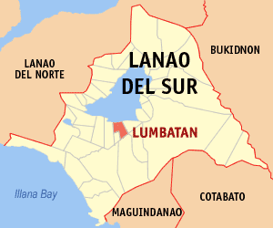
Lumbatan, officially the Municipality of Lumbatan, is a 5th class municipality in the province of Lanao del Sur, Philippines. According to the 2020 census, it has a population of 22,780 people.

Saguiaran, officially the Municipality of Saguiaran, is a 4th class municipality in the province of Lanao del Sur, Philippines. According to the 2020 census, it has a population of 26,712 people.
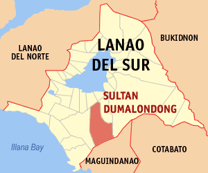
Sultan Dumalondong, officially the Municipality of Sultan Dumalondong, is a 6th class municipality in the province of Lanao del Sur, Philippines. According to the 2020 census, it has a population of 12,500 people.
Ozamiz, officially the City of Ozamiz, is a 3rd class component city in the province of Misamis Occidental, Philippines. According to the 2020 census, it has a population of 140,334 people.
The legislative districts of Lanao del Sur are the representations of the province of Lanao del Sur in the various national legislatures of the Philippines. The province is currently represented in the lower house of the Congress of the Philippines through its first and second congressional districts.

Lake Dapao is a deep water lake located in the province of Lanao del Sur, southwest of Lake Lanao, in the island of Mindanao in the Philippines. It is one of the deepest lakes in the country, reaching a maximum depth of 120 metres (390 ft). It has an estimated surface area of 1,011 hectares (10.11 km2). The lake receives water from local run-off and several small rivers.
Sacred Mountain National Park is a national park in Marawi, Lanao del Sur in the Southern Philippines. The 94-hectare (230-acre) national park and protected area, located in Brgys. Guimba and Papandayan, was established on August 5, 1965 by Republic Act no. 4190. The main geographic feature of the park is Mount Mupo which has the height of 274.32-meter (900.0 ft). Activities in the park include birdwatching and trekking to the mountaintop where a pond is located.
Pantuwaraya Lake National Park is a protected area of the Philippines located in barangay Pantao Raya in the municipality of Saguiaran, Lanao del Sur. The park covers an area of 20 hectares comprising Lake Pantao Raya and surrounding area. It was declared a national park in 1965 by virtue of Republic Act No. 4190.
Rungkunan National Park is a protected area of the Philippines located in the municipalities of Ditsaan-Ramain and Tagoloan II in Lanao del Sur, some 10 kilometers east-south-east of the provincial capital Marawi. The park covers the mountainous eastern section of Lanao del Sur near the Lake Lanao-Agus River Watershed Area known for its beautiful sparkling stream, virgin forest and invigorating climate. It was declared a national park in 1965 by virtue of Republic Act No. 4190.
Salikata National Park is a protected area of the Philippines located in the municipality of Lumba-Bayabao, Lanao del Sur in Mindanao Island. Nestled in the thickly forested foothills of the Mount Ragang range, the park is one of the six national parks in the province of Lanao del Sur declared in 1965. The area is characterized by waterfalls, river gorge, rocky cliffs and dense canopy stretching the length of the Gata River valley from barangay Salaman to Mapantao near the provincial border with Cotabato.

Pindolonan National High School is a high school located at the center of the Municipality of Butig, Province of Lanao del Sur, in the Barangay Pindolonan, Philippines. It has 15,000 square meters land area duly donated by late Municipal Councilor, Datu Ditual Bundas Maliwanag. The area is bounded at east by the Sawa River, west by Lake Butig, north by Sultan Dimnatang Ditual and south by Macabago Canapi.

The Mount Inayawan Range Natural Park is a protected area of forested mountains in the Northern Mindanao region of the Philippines. The park encompasses the mountain range also known as Mount Iniaoan located in the landlocked municipality of Nunungan in Lanao del Norte and covers a total area of 3,632.74 hectares with a buffer zone of 889.04 hectares. The area was officially designated as a natural park on 30 July 2007 through Proclamation No. 1344 signed by President Gloria Arroyo. It is a critical watershed area and the largest remaining rainforest in Lanao del Norte.
The 2016 Butig clashes were armed conflicts that began on February 20, 2016, between the Philippine Army and a group of Moro insurgent sympathizers of ISIS and Jemaah Islamiyah led by the Maute group in Butig, Lanao del Sur, Philippines. Three Philippine Army soldiers were killed in action, 11 wounded, and 20 terrorists killed in the early phase of battle. 335 families fled to Marawi City and 657 families took refuge in Masiu.

The Maute group, also known as the Islamic State of Lanao, was a radical Islamist group composed of former Moro Islamic Liberation Front guerrillas and foreign fighters led by Omar Maute, the alleged founder of a Dawlah Islamiya, or Islamic state, based in Lanao del Sur, Mindanao, Philippines. The group, which a Philippine Army brigade commander characterized as terrorist, had been conducting a protection racket in the remote settlements of Butig, Lanao del Sur. It had clashed on several occasions with Armed Forces of the Philippines troops, the most significant of which began in May 2017 and culminated in the Battle of Marawi.

