
Palawan, officially the Province of Palawan, is an archipelagic province of the Philippines that is located in the region of Mimaropa. It is the largest province in the country in terms of total area of 14,649.73 km2 (5,656.29 sq mi). The capital city is Puerto Princesa. Palawan is known as the Philippines' Last Frontier and as the Philippines' Best Island.

The Philippine Sea is a marginal sea of the Western Pacific Ocean east of the Philippine archipelago, the largest in the world, occupying an estimated surface area of 5 million square kilometers. The Philippine Sea Plate forms the floor of the sea. Its western border is the first island chain to the west, comprising the Ryukyu Islands in the northwest and Taiwan in the west. Its southwestern border comprises the Philippine islands of Luzon, Catanduanes, Samar, Leyte, and Mindanao. Its northern border comprises the Japanese islands of Honshu, Shikoku and Kyūshū. Its eastern border is the second island chain to the west, comprising the Bonin Islands and Iwo Jima in the northeast, the Mariana Islands in the due east, and Halmahera, Palau, Yap and Ulithi in the southeast. Its southern border is Indonesia's Morotai Island.
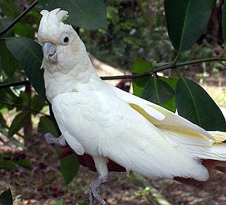
The red-vented cockatoo, also known as the Philippine cockatoo and locally katala, abukay, agay or kalangay, is a critically endangered species of cockatoo that is endemic to the Philippines though pressured by various environmental degradation and illegal pet trades, the population of the Philippine cockatoo is somehow growing owing to Katala Organization.It is roughly the size and shape of the Tanimbar corella, but is easily distinguished by the red feathers around the vent. It is threatened by habitat loss and the cage-bird trade.

Pamalican Island, also known as Pamalikan, is a small and sandy island of the Cuyo Islands in the Sulu Sea, between Palawan and Panay, in the north part of the Palawan Province of the Philippines. The island is set in the middle of a 7-square-kilometre (2.7 sq mi) coral reef. It has a length of 2.5 kilometres (1.6 mi), and measures only 500 metres (1,600 ft) at its widest point. Pamalican can be found 7 miles southwest of Quiniluban island and 3 miles northeast of Manamoc island.

Narra, officially the Municipality of Narra, is a 1st class municipality in the province of Palawan, Philippines. According to the 2020 census, it has a population of 77,948 people.

The Tubbataha Natural Park, also known as the Tubbataha Reefs Natural Park, is a protected area of the Philippines located in the middle of the Sulu Sea. The marine and bird sanctuary consists of two huge atolls and the smaller Jessie Beazley Reef covering a total area of 97,030 hectares. It is located 150 kilometres (93 mi) southeast of Puerto Princesa, the capital of Palawan. The uninhabited islands and reefs are part of the island municipality of Cagayancillo, located roughly 130 kilometers (81 mi) to the northeast of the reef.

The Puerto Princesa Subterranean River National Park is a protected area in the Philippines.
The Key West National Wildlife Refuge is a 189,497 acre (766.867 km2) National Wildlife Refuge located in Monroe County, Florida, between Key West, Florida and the Dry Tortugas. Only 2,019 acres (8.171 km2) of land are above sea level, on several keys within the refuge. These keys are unpopulated and are also designated as Wilderness within the Florida Keys Wilderness. The refuge was established to provide a preserve and breeding ground for native birds and other wildlife as well as to provide habitat and protection for endangered and threatened fish, wildlife, plants and migratory birds.

Apo Reef is a coral reef system in the Philippines situated in the western waters of Occidental Mindoro province in the Mindoro Strait. Encompassing 34 square kilometres (13 sq mi), it is considered the world's second-largest contiguous coral reef system, and is the largest in the country. The reef and its surrounding waters are protected areas administered as the Apo Reef Natural Park (ARNP). It is one of the best known and most popular diving regions in the country, and is in the tentative list for UNESCO World Heritage Sites.
Katala Foundation, Inc. (KF) is a non-profit, non-stock and non-governmental organization that is active in protecting and conserving wildlife, particularly the critically endangered Philippine cockatoo or red-vented cockatoo and other threatened endemic wildlife in the Philippines. It implements the Philippine Cockatoo Conservation Program (PCCP) with target sites in the island of Palawan, the stronghold of the species. It considers the Philippine cockatoo as its flagship species but employs an ecosystemic and participatory approach for conservation where people are given important roles in the entirety of the program implementation. Among the activities of the PCCP are nest protection, livelihood, habitat protection and restoration and conservation education.

The Olango Island Group is a group of islands found in the Central Visayas region of the Philippines. It comprises Olango island and 6 satellite islets namely: Caubian, Camungi, Caohagan, Gilutongan, Nalusuan, Pangan-an, and Sulpa. The island group has a total land area of approximately 1,030 hectares. It is divided under the jurisdiction of the city of Lapu-Lapu and the municipality of Cordova, Cebu. It lies 5 kilometers (3.1 mi) east of Mactan and is a major tourist destination in Cebu. It is known for its wildlife sanctuary. The entire area is the first declared Ramsar Wetland Site in the Philippines, as recognized in 1994.

Madagascar mangroves are a coastal ecoregion in the mangrove forest biome found on the west coast of Madagascar. They are included in the WWF's Global 200 list of most outstanding ecoregions.
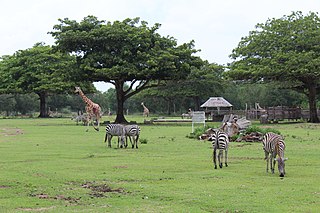
Calauit Safari Park is a wildlife sanctuary in the Philippines which was originally created in 1976 as a game reserve featuring large African mammals, translocated there under the orders of the President Ferdinand Marcos during his 21-year rule of the country.

Solitary Islands Marine Park (SIMP) is a marine park in New South Wales State waters, Australia. It adjoins the Solitary Islands Marine Reserve and was declared under the Marine Parks Act 1997 (NSW) in January 1998. Prior to this it was declared a marine reserve in 1991. The Park was one of the first declared in NSW and stretches along the northern NSW coast, from Muttonbird Island, Coffs Harbour, to Plover Island near Sandon River, 75 kilometres to the north. It includes coastal estuaries and lakes and extends from the mean high water mark, to three nautical miles out to sea, covering an area of around 72 000 hectares. There are five main islands in the Park, North Solitary Island, North West Solitary Island, South West Solitary Island, South Solitary Island and Split Solitary Island, as well as other significant outcrops such as Muttonbird Island and submerged reefs.
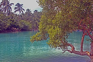
Malampaya Sound is a protected inlet of the South China Sea on the northwestern coast of Palawan Island in western Philippines. It is a geographic sound consisting of a complex of sheltered bays, coves, estuaries and islands separated from the sea to the west by the Copoas Peninsula. The sound is within the municipality of Taytay and is an important feature for the ecology and economy of the province of Palawan. It is considered one of the finest natural harbors in the Philippines and one of Palawan's richest fishing grounds.
Alibijaban is a small island located off the southeastern coast of Bondoc Peninsula in the Philippines. It belongs administratively to the municipality of San Andres, Quezon province, and is coterminous with the barangay of the same name. With a population of 1,643 inhabitants in 2015, it is the smallest of seven barangays in San Andres.
Malabungot, alternatively spelled as Malabungut, and also known as Mahad, is an island in Binagasbasan Bay off the coast of Garchitorena in Camarines Sur, Philippines. It is separated from Caramoan Peninsula in the south by the Quinalasag Passage, also known as Sisiran Passage, which connects Lamit and Sisiran bays. The island forms the head of Binagasbasan Bay, bordered to the west by the Lamit Islands and to the east by Quinalasag Island, and which opens northward to the Philippine Sea. It is designated as a protected landscape and seascape on account of its biodiversity and ecological significance.
The Mabini Protected Landscape and Seascape, in Davao de Oro, Philippines, is a terrestrial and marine protected area established in 2000 to protect ecologically significant habitats in the Davao Gulf. The park extends along the coast of the municipality of Mabini from the mouth of the Pandasan River to the southern tip of Kopiat Island. It also includes Lunod Island, also known as Pandasan Island, which was earlier declared a wilderness area in 1981. It covers 6,106 hectares of extensive mangrove forests, white sand beaches and rich coral reef systems.
The Guiuan Protected Landscape and Seascape, also known as the Guiuan Marine Reserve, is a protected area associated with the Guiuan Island Group which is located off the coast of the municipality of Guiuan on the eastern side of Leyte Gulf in the Philippines. The protected area consists of the following islands from within the group: Calicoan, Manicani, Suluan, Tubabao, Victory, Homonhon and other smaller islands and their surrounding reefs. It also includes the coastal area of mainland Guiuan in Eastern Samar covering a total area of 60,448 hectares. The land which now comprises the conservation area was previously declared as a Marine Reserve and Tourist Zone and was placed under the administration and control of the Philippine Tourism Authority in 1978. It was re-proclaimed and re-classified as a protected landscape/seascape in 1994 under the National Integrated Protected Areas System Act of 1992.
Turtle Islands Wildlife Sanctuary is a protected area in the municipality of Turtle Islands in Tawi-Tawi, Philippines.
