Coral island

Last updated
A coral island in Maldives Diamonds Thudufushi Beach and Water Villas, May 2017 -08.jpg
A coral island in Maldives

A coral island is a type of island formed from coral detritus and associated organic material. [1] It occurs in tropical and sub-tropical areas, typically as part of a coral reef which has grown to cover a far larger area under the sea. The term low island can be used to distinguish such islands from high islands, which are formed through volcanic action. [2] Low islands are formed as a result of sedimentation upon a coral reef or of the uplifting of such islands.

Contents

Ecosystem

Healthy reef system Coral reef at palmyra.jpg
Healthy reef system

Coral reefs are some of the oldest ecosystems on the planet, over geological time, they form massive reefs of limestone. The reef environment supports more plant and animal species than any other habitat. [3] [4] Coral reefs are vital for life in multiple aspects some of which include structure, ecology, and nutrient cycles which all support biodiversity in the reefs.

Coral reefs build massive calcareous skeletons that serve as homes for animals such as fish hiding inside the crooks and crannies of the reef and barnacles attaching themselves directly to the coral's structure. The structures also help plants that need the sun to photosynthesize, by lifting the plants to the ocean's surface where the sunlight can penetrate the water. The structures also create calm zones in the ocean providing a place for fish and plant species to thrive.

Over geological time a reef may reach the surface and can become a coral island, where it begins a whole new ecosystem for land-based creatures. [5]

Formation

Volcano with fringing reef, to barrier reef, and finally formation into a coral atoll Coral atoll formation animation.gif
Volcano with fringing reef, to barrier reef, and finally formation into a coral atoll

A coral island begins as a volcanic island over a hot spot. As the volcano emerges from the sea, a fringing reef grows on the outskirt of the volcano. The volcano eventually moves off the hot spot by means of plate tectonics. Once this occurs, the volcano can no longer keep up with the wave erosion and undergoes subsidence.

Once the island is submerged, the coral must keep growing to stay in the epipelagic zone. This causes the coral to grow into an atoll with a shallow lagoon in the middle. The lagoon undergoes accretion and creates an island completely made of carbonate materials. The process is later enhanced with the remains of plant life which grows on the island. [6]

Low vs. high island

The term "low island" refers to geologic origin rather than a strict classification of height. Some low islands, such as Banaba, Makatea, Nauru, and Niue, rise several hundred feet above sea level, while numerous high islands (those of volcanic origin) rise a few feet above sea level, often classified as "rocks". Low islands ring the lagoons of atolls. The two types of islands are often found in proximity to each other. This is especially the case among the islands of the South Pacific Ocean, where low islands are found on the fringing reefs that surround most high islands.[ citation needed ]

Distribution

Most of the world's coral islands are in the Pacific Ocean, but they are also found in the Atlantic and Indian Oceans. The American territories of Jarvis, Baker and Howland Islands are clear examples of coral islands in the Pacific. Atolls in the Atlantic are found in Colombia's Archipelago of San Andrés, Providencia and Santa Catalina. The Lakshadweep Islands union territory of India is a group of 39 coral islands, along with some minor islets and banks. Some of the islands belonging to Kiribati are considered coral islands. The Maldives consist of coral islands. St. Martin's Island is an 8 km2 (3.1 sq mi) coral island located in Bangladesh. Coral islands are located near Pattaya and Ko Samui, Thailand. [7]

Ecology

Bleached coral due to rising sea temperature, increased acidity, and/or pollution. Bleached coral, Acoropora sp.jpg
Bleached coral due to rising sea temperature, increased acidity, and/or pollution.

Coral is important for biodiversity and the growth of fish populations, so maintaining coral reefs is important. Many coral islands are small with low elevation above sea level. Thus they are at threat from storms and rising sea levels. Through chemical and physical changes humans can cause significant harm to reef systems and slow the creation of coral island chains. [5]

Coral reefs are threatened by numerous anthropogenic impacts, some of which have already had major effects worldwide. [8] Reefs grow in shallow, warm, nutrient-poor waters where they are not outcompeted by phytoplankton. By adding fertilizers into the water runoff, phytoplankton populations can explode and choke out coral reef systems. Adding too many sediments can cause a similar problem by blocking out the sun, starving the zooxanthellae that live on coral causing it to undergo a process known as coral bleaching.

The ocean's acidity is also a factor. Coral is made of calcium carbonate and is dissolved by carbonic acid. With the increase in carbon dioxide from combustion reactions in the atmosphere through precipitation, carbon dioxide mixes with water and forms carbonic acid, raising the ocean's acidity which slows coral growth.

Although low islands may have fewer potential habitats than high islands, thus lower species diversity, studies of both types of islands in Palau found that species diversity, at least in the waters around the island, is more affected by island size than by its origin. [9]

Climate and habitability

Low islands have poor, sandy soil and little fresh water, which makes them difficult to farm. They cannot support human habitation as well as high islands. They are also threatened by sea level rise due to global warming. The people that do live on low islands survive mostly by fishing. Low islands usually have an oceanic climate.
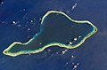
See also

Related Research Articles

<span class="mw-page-title-main">Marine biology</span> Scientific study of organisms that live in the ocean

Marine biology is the scientific study of the biology of marine life, organisms in the sea. Given that in biology many phyla, families and genera have some species that live in the sea and others that live on land, marine biology classifies species based on the environment rather than on taxonomy.

<span class="mw-page-title-main">Geography of Nauru</span>

Nauru is a tiny phosphate rock island nation located in the South Pacific Ocean south of the Marshall Islands in Oceania. It is only 53 kilometres (33 mi) south of the Equator at coordinates 0°32′S166°55′E. Nauru is one of the three great phosphate rock islands in the Pacific Ocean—the others are Banaba in Kiribati and Makatea in French Polynesia.

<span class="mw-page-title-main">Geography of Tuvalu</span> Overview of the geography of Tuvalu

The Western Pacific nation of Tuvalu, formerly known as the Ellice Islands, is situated 4,000 kilometers (2,500 mi) northeast of Australia and is approximately halfway between Hawaii and Australia. It lies east-northeast of the Santa Cruz Islands, southeast of Nauru, south of Kiribati, west of Tokelau, northwest of Samoa and Wallis and Futuna and north of Fiji. It is a very small island country of 26 km2 (10 sq mi). Due to the spread out islands it has the 38th largest Exclusive Economic Zone of 749,790 km2 (289,500 sq mi). In terms of size, it is the second-smallest country in Oceania.

<span class="mw-page-title-main">Atoll</span> Ring-shaped coral reef

An atoll is a ring-shaped island, including a coral rim that encircles a lagoon. There may be coral islands or cays on the rim. Atolls are located in warm tropical or subtropical parts of the oceans and seas where corals can develop. Most of the approximately 440 atolls in the world are in the Pacific Ocean.

<span class="mw-page-title-main">Coral reef</span> Outcrop of rock in the sea formed by the growth and deposit of stony coral skeletons

A coral reef is an underwater ecosystem characterized by reef-building corals. Reefs are formed of colonies of coral polyps held together by calcium carbonate. Most coral reefs are built from stony corals, whose polyps cluster in groups.

<span class="mw-page-title-main">Guyot</span> Isolated, flat-topped underwater volcano mountain

In marine geology, a guyot, also called a tablemount, is an isolated underwater volcanic mountain (seamount) with a flat top more than 200 m (660 ft) below the surface of the sea. The diameters of these flat summits can exceed 10 km (6 mi). Guyots are most commonly found in the Pacific Ocean, but they have been identified in all the oceans except the Arctic Ocean. They are analogous to tables on land.

<span class="mw-page-title-main">Aldabra</span> Coral atoll in the Indian Ocean

Aldabra is the world's second-largest coral atoll, lying southeast of the continent of Africa. It is part of the Aldabra Group of islands in the Indian Ocean that are part of the Outer Islands of the Seychelles, with a distance of 1,120 km (700 mi) southwest of the capital, Victoria on Mahé Island. Initially named by Arab seafarers for its harsh environment, Aldabra became a French colony dependency in the 18th century, leading to the exploitation of its natural resources, particularly giant tortoises. After passing through British hands, Aldabra faced potential military use in the 1960s, but international protests resulted in its protection. The atoll boasts unique geography, featuring the world's largest raised coral reef and a large shallow lagoon. Aldabra's history involves human impact, including failed agricultural ventures. Post-World War II, conservation efforts increased, leading to its inclusion in the British Indian Ocean Territory and eventual independence for Seychelles. Following an international protest by scientists known as the 'Aldabra Affair,' the Royal Society of London and later the Seychelles Islands Foundation conducted research, leading to Aldabra's declaration as a UNESCO World Heritage Site in 1982. The atoll's flora and fauna, notably the giant tortoises, comprise an 'ecological wonder', with Aldabra serving as a critical breeding ground for various species. Conservation challenges, such as invasive species and plastic pollution, persist, but protective measures, including UNESCO designation, underscore Aldabra's significance as a natural vital scientific research site. Aldabra receives limited tourism to safeguard its delicate ecosystem and is accessible primarily through guided tours.

<span class="mw-page-title-main">Evolution of Hawaiian volcanoes</span> Processes of growth and erosion of the volcanoes of the Hawaiian islands

The fifteen volcanoes that make up the eight principal islands of Hawaii are the youngest in a chain of more than 129 volcanoes that stretch 5,800 kilometers (3,600 mi) across the North Pacific Ocean, called the Hawaiian–Emperor seamount chain. Hawaiʻi's volcanoes rise an average of 4,600 meters (15,000 ft) to reach sea level from their base. The largest, Mauna Loa, is 4,169 meters (13,678 ft) high. As shield volcanoes, they are built by accumulated lava flows, growing a few meters or feet at a time to form a broad and gently sloping shape.

<span class="mw-page-title-main">Volcanic island</span> Island of volcanic origin

Geologically, a volcanic island is an island of volcanic origin. The term high island can be used to distinguish such islands from low islands, which are formed from sedimentation or the uplifting of coral reefs.

<span class="mw-page-title-main">Marine ecosystem</span> Ecosystem in saltwater environment

Marine ecosystems are the largest of Earth's aquatic ecosystems and exist in waters that have a high salt content. These systems contrast with freshwater ecosystems, which have a lower salt content. Marine waters cover more than 70% of the surface of the Earth and account for more than 97% of Earth's water supply and 90% of habitable space on Earth. Seawater has an average salinity of 35 parts per thousand of water. Actual salinity varies among different marine ecosystems. Marine ecosystems can be divided into many zones depending upon water depth and shoreline features. The oceanic zone is the vast open part of the ocean where animals such as whales, sharks, and tuna live. The benthic zone consists of substrates below water where many invertebrates live. The intertidal zone is the area between high and low tides. Other near-shore (neritic) zones can include mudflats, seagrass meadows, mangroves, rocky intertidal systems, salt marshes, coral reefs, lagoons. In the deep water, hydrothermal vents may occur where chemosynthetic sulfur bacteria form the base of the food web.

<span class="mw-page-title-main">Fringing reef</span> Type of coral reef

A fringing reef is one of the three main types of coral reef. It is distinguished from the other main types, barrier reefs and atolls, in that it has either an entirely shallow backreef zone (lagoon) or none at all. If a fringing reef grows directly from the shoreline, then the reef flat extends to the beach and there is no backreef. In other cases, fringing reefs may grow hundreds of yards from shore and contain extensive backreef areas within which it contains food and water. Some examples of this are Philippines, Indonesia, Timor-Leste, the western coast of Australia, the Caribbean, East Africa, and Red Sea. Charles Darwin believed that fringing reefs are the first kind of reefs to form around a landmass in a long-term reef growth process. The largest fringing coral reef in the world is the Ningaloo Reef, stretching to around 260 km (160 mi) along the coastline of Western Australia.

Aquatic science is the study of the various bodies of water that make up our planet including oceanic and freshwater environments. Aquatic scientists study the movement of water, the chemistry of water, aquatic organisms, aquatic ecosystems, the movement of materials in and out of aquatic ecosystems, and the use of water by humans, among other things. Aquatic scientists examine current processes as well as historic processes, and the water bodies that they study can range from tiny areas measured in millimeters to full oceans. Moreover, aquatic scientists work in Interdisciplinary groups. For example, a physical oceanographer might work with a biological oceanographer to understand how physical processes, such as tropical cyclones or rip currents, affect organisms in the Atlantic Ocean. Chemists and biologists, on the other hand, might work together to see how the chemical makeup of a certain body of water affects the plants and animals that reside there. Aquatic scientists can work to tackle global problems such as global oceanic change and local problems, such as trying to understand why a drinking water supply in a certain area is polluted.

<span class="mw-page-title-main">Marianas Trench Marine National Monument</span> US national monument in the Mariana Archipelago

The Marianas Trench Marine National Monument is a United States National Monument created by President George W. Bush by the presidential proclamation no. 8335 on January 6, 2009. The monument includes no dry land area, but protects 95,216 square miles (246,610 km2) of submerged lands and waters in various places in the Mariana Archipelago. The United States could create this monument under international law because the maritime exclusive economic zones of the adjacent Northern Mariana Islands and Guam fall within its jurisdiction.

<i>The Structure and Distribution of Coral Reefs</i> Book published in 1842 by Charles Darwin

The Structure and Distribution of Coral Reefs, Being the first part of the geology of the voyage of the Beagle, under the command of Capt. Fitzroy, R.N. during the years 1832 to 1836, was published in 1842 as Charles Darwin's first monograph, and set out his theory of the formation of coral reefs and atolls. He conceived of the idea during the voyage of the Beagle while still in South America, before he had seen a coral island, and wrote it out as HMS Beagle crossed the Pacific Ocean, completing his draft by November 1835. At the time there was great scientific interest in the way that coral reefs formed, and Captain Robert FitzRoy's orders from the Admiralty included the investigation of an atoll as an important scientific aim of the voyage. FitzRoy chose to survey the Keeling Islands in the Indian Ocean. The results supported Darwin's theory that the various types of coral reefs and atolls could be explained by uplift and subsidence of vast areas of the Earth's crust under the oceans.

<span class="mw-page-title-main">Marine habitat</span> Habitat that supports marine life

A marine habitat is a habitat that supports marine life. Marine life depends in some way on the saltwater that is in the sea. A habitat is an ecological or environmental area inhabited by one or more living species. The marine environment supports many kinds of these habitats.

The Funafuti Conservation Area is a marine conservation area covering 33 square kilometers of reef, lagoon and motu (islets) on the western side of Funafuti atoll in Tuvalu. The marine environment of the conservation area includes reef, lagoon, channel and ocean; and are home to many species of fish, corals, algae and invertebrates. The islets are nesting sites for the green sea turtle and Fualopa hosts a breeding colony of black noddy.

<span class="mw-page-title-main">Coral reefs of Tuvalu</span> List of coral reefs in Tuvalu

The coral reefs of Tuvalu consist of three reef islands and six atolls, containing approximately 710 km2 (270 sq mi) of reef platforms. The islands of the Tuvalu archipelago are spread out between the latitude of 5° to 10° south and longitude of 176° to 180°, west of the International Date Line. The islands of Tuvalu are volcanic in origin. On the atolls, an annular reef rim surrounds the lagoon, and may include natural reef channels. The reef islands have a different structure to the atolls, and are described as reef platforms as they are smaller tabular reef platforms that do not have a salt-water lagoon, although they may have a completely closed rim of dry land, with the remnants of a lagoon that has no direct connection to the open sea or that may be drying up.

<span class="mw-page-title-main">Coral reefs of Kiribati</span> Pacific Ocean Island chain

The Coral reefs of Kiribati consists of 32 atolls and one raised coral island, Banaba, which is an isolated island between Nauru and the Gilbert Islands. The islands of Kiribati are dispersed over 3.5 million km2 (1.4 million sq mi) of the Pacific Ocean and straddle the equator and the 180th meridian, extending into the eastern and western hemispheres, as well as the northern and southern hemispheres. 21 of the 33 islands are inhabited. The groups of islands of Kiribati are:

<span class="mw-page-title-main">Coral reefs of the Solomon Islands</span>

The Coral reefs of the Solomon Islands consists of six major islands and over 986 smaller islands, in Oceania, to the east of Papua New Guinea and northwest of Vanuatu. The Solomon Islands lie between latitudes 5° and 13°S, and longitudes 155° and 169°E. The distance between the westernmost and easternmost islands is about 1,500 km (930 mi). The Santa Cruz Islands are situated north of Vanuatu and are especially isolated at more than 200 km (120 mi) from the other islands. The Solomon Islands has the 22nd largest Exclusive Economic Zone of 1,589,477 km2 (613,701 sq mi) of the Pacific Ocean.

<span class="mw-page-title-main">Geology of the Cook Islands</span> Geology of Cook Islands

There are fifteen Cook Islands, all being related to extinct volcanoes that have erupted in the volcanic hotspot highway of the south-central Pacific Ocean. Low islands include six of the more northern islands that are atolls, and four of the more southern being uplifted coral islands. Rarotonga, the largest island of the group is a mountainous volcanic island. Rock formations include late Pliocene to more recent volcanics, Oligocene and Miocene reefs and middle Tertiary limestone underlying atolls More recent emergence of the coral reefs is characterised in several cases consistent with sealevel fall at Mangaia, of at least 1.7 m in the last 3400 years. The northern Suwarrow Atoll rim has portions of reef dated to between 4680 and 4310 years B.P. and at the northeast of the atoll the three ridges are dated from the land out at 4220 years B.P., 3420 years B.P. and from 1250 years B.P. On Mitiaro the centre of the reef flat has regions dated 5140–3620 years B.P.

References

  1. "coral island". Encyclopædia Britannica. Retrieved 2012-12-26.
  2. Murphy, Raymond E. (July 1949). "'High' and 'Low' Islands in the Eastern Carolines". Geographical Review. 39 (3). doi:10.2307/210643. JSTOR   210643.
  3. Barnes, R.S.K.; Mann, K.H. (1991). Fundamentals of Aquatic Ecology. Blackwell Publishing. pp. 217–227. ISBN   978-0-632-02983-9.
  4. Fuchs. T (2013). "Effects of Coral Reef Complexity on Invertebrate Biodiversity". Immediate Science Ecology Publishing: 1–10. Archived from the original on April 2, 2015.
  5. 1 2 Heatwole, Harold (1981). A Coral IslandL The story of One Tree Island. Australia: William Collins. p. 130. ISBN   978-0002164429.
  6. Erickson, Jon (2003). Marine Geology: Exploring New Frontiers of the Ocean . United States: Facts on File, Inc. pp.  126. ISBN   978-0816048748.
  7. Andréfouët, Serge; Guzman, Hector M. (2005-03-01). "Coral reef distribution, status and geomorphology–biodiversity relationship in Kuna Yala (San Blas) archipelago, Caribbean Panama". Coral Reefs. 24 (1): 31–42. doi:10.1007/s00338-004-0444-4. ISSN   0722-4028. S2CID   11831104.
  8. SEBENS, KENNETH P. (February 1994). "Biodiversity of Coral Reefs: What are We Losing and Why?". American Zoologist. 34 (1): 115–133. doi: 10.1093/icb/34.1.115 . ISSN   0003-1569.
  9. Donaldson, Terry J. (2002). "High Islands Versus Low Islands: A Comparison of Fish Faunal Composition of the Palau Islands". Environmental Biology of Fishes. 65 (2): 241–248. Bibcode:2002EnvBF..65..241D. doi:10.1023/A:1020067931910. ISSN   0378-1909.