Davao Gulf is a gulf situated in the southeastern portion of Mindanao in the Philippines. It has an area of 5,200 km2 (2,000 sq mi) or about 520,000 hectares. Davao Gulf cuts into the island of Mindanao from the Philippine Sea. It is surrounded by all five provinces in the Davao Region. The largest island in the gulf is Samal Island. Davao City, on the Gulf's west coast, is the largest and busiest port on the gulf. The Bagobo and the Kaagan / Kalagan, who are the indigenous Lumad tribes endemic to Davao, are known inhabitants of the said gulf.

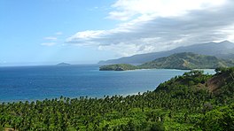
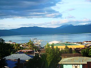
Mati, officially the City of Mati, is a 5th class component city and capital of the province of Davao Oriental, Philippines located on the southeasternmost side of Mindanao and is part of Metropolitan Davao, the second-most populous metropolitan area in the Philippines, and its managing entity, the MDDA. According to the 2020 census, it has a population of 147,547 people making it the most populous in the province.

Apo Reef is a coral reef system in the Philippines situated in the western waters of Occidental Mindoro province in the Mindoro Strait. Encompassing 34 square kilometres (13 sq mi), it is considered the world's second-largest contiguous coral reef system, and is the largest in the country. The reef and its surrounding waters are protected areas administered as the Apo Reef Natural Park (ARNP). It is one of the best known and most popular diving regions in the country, and is in the tentative list for UNESCO World Heritage Sites.

The Olango Island Group is a group of islands found in the Central Visayas region of the Philippines. It comprises Olango island and 6 satellite islets namely: Caubian, Camungi, Caohagan, Gilutongan, Nalusuan, Pangan-an, and Sulpa. The island group has a total land area of approximately 1,030 hectares. It is divided under the jurisdiction of the city of Lapu-Lapu and the municipality of Cordova, Cebu. It lies 5 kilometers (3.1 mi) east of Mactan and is a major tourist destination in Cebu. It is known for its wildlife sanctuary. The entire area is the first declared Ramsar Wetland Site in the Philippines, as recognized in 1994.
The Las Piñas–Parañaque Critical Habitat and Ecotourism Area (LPPCHEA), also known as the Las Piñas–Parañaque Wetland Park, is a protected area at the coasts of the cities of Las Piñas and Parañaque in Metro Manila, Philippines. The entire wetland is a declared Ramsar site under the Ramsar Convention of UNESCO.
Bongsanglay Natural Park is a protected area of mangrove forests and swamps on Ticao Island in the Bicol Region of the Philippines. It is located in the municipality of Batuan in the island province of Masbate covering an area of 244.72 hectares. The protected area was established on 29 December 1981 when the area "from Panciscan Point in Bitos Bay up to Bano Sanlay" in Batuan was declared a Mangrove Swamp Forest Reserve under Proclamation No. 2152 signed by President Ferdinand Marcos. In 2000, when President Joseph Estrada signed Proclamation No. 319, Bongsanglay was reclassified as a natural park pursuant to the National Integrated Protected Areas System (NIPAS) Act.
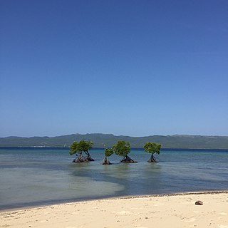
The Mati Protected Landscape is a protected area located in Davao Oriental on the southern Philippine island of Mindanao. It protects the watershed in Mati which is the source of water supply for the city's Mati Waterworks System. The protected area was established in 1967 when 890 hectares of forest in Central Mati was proclaimed as the Mati Watershed Forest Reserve through Proclamation No. 222 issued by President Ferdinand Marcos. Under the National Integrated Protected Areas System, the area was reclassified as a protected landscape with the signing of Proclamation No. 912 in 2005 by President Gloria Arroyo.
The Mainit Hot Springs Protected Landscape is a protected landscape area located in the province of Davao de Oro on the island of Mindanao in the Philippines. It preserves the sulfuric hot springs and surrounding forest in Nabunturan municipality which also contains the headwaters of the Manat River, a source of water supply for surrounding villages. First declared a national park in 1957 by virtue of Proclamation No. 466 by President Carlos P. Garcia, it had an initial area of 1,381 hectares. Under the National Integrated Protected Areas System, it was reclassified as a protected landscape through Proclamation No. 320 issued in 2000 by President Joseph Estrada. The hot springs are a popular ecotourist attraction in Davao de Oro. Its name "Mainit" is a Filipino word which means hot.
Murcielagos Island locally known as Pulo Baliudyong is a small low-lying island in the Sulu Sea off the coast of Zamboanga del Norte in the southern Philippine island of Mindanao. It measures over 500 metres (1,600 ft) across at its widest point and is situated on an oval reef about 1.6 kilometres (0.99 mi) in length. situated in 4.8 kilometres (3.0 mi) north of Quipit Point on the west side of Patauag Bay in the Zamboanga municipality of Labason. It is known for its white coral-sand beaches and rich marine resources. To its west lies an islet called Bayangan Island. The two islands are collectively known as Murcielagos Islands and are administratively part of the Labason poblacion of Antonino.

Selinog, historically known as Silino and also named Silinog, is an island barangay in Dapitan, Zamboanga del Norte, Philippines. It is coterminous with Silino Island and is located 12.9 kilometres (8.0 mi) off Tagolo Point, the northern entrance point to Dapitan Bay, and some 15 kilometres (9.3 mi) east of the island of Aliguay in the Bohol Sea. The island is a flat coralline island with a land area of 78 hectares. It is surrounded by 70 hectares of coral reefs and sandy areas. According to the 2020 census, the island community has a population of 692 inhabitants.
Rasa Island is a flat coral island in the Sulu Sea just off the coast of the municipality of Narra in Palawan, Philippines. It is a shallow island surrounded by mangroves and tidal flats containing one of the country's last remaining coastal forests. The island is home to the largest population of the endemic and critically endangered Philippine cockatoo in the wild in the Philippines. It was declared a protected area in 2006.
Dumanquilas Bay is an arm of the Moro Gulf on the southern side of the Zamboanga Peninsula in western Mindanao island in the Philippines. It is shared between the provinces of Zamboanga del Sur on the eastern and northern shore, and Zamboanga Sibugay on the western shore. An irregularly shaped peninsula extending to Flecha Point separates it from Pagadian Bay to the east, while to the west, the bay connects with Sibuguey Bay through Canalizo Strait which separates Olutanga island from the mainland of Zamboanga. Politically, it is divided between the Zamboanga del Sur municipalities of Margosatubig, Vincenzo Sagun, Lapuyan and Kumalarang, and the Zamboangay Sibugay municipalities of Buug, Malangas and Alicia.

Malampaya Sound is a protected inlet of the South China Sea on the northwestern coast of Palawan Island in western Philippines. It is a geographic sound consisting of a complex of sheltered bays, coves, estuaries and islands separated from the sea to the west by the Copoas Peninsula. The sound is within the municipality of Taytay and is an important feature for the ecology and economy of the province of Palawan. It is considered one of the finest natural harbors in the Philippines and one of Palawan's richest fishing grounds.
Alibijaban is a small island located off the southeastern coast of Bondoc Peninsula in the island of Luzon. It belongs administratively to the municipality of San Andres, Quezon province, and is coterminous with the barangay of the same name. With a population of 1,738 inhabitants in 2020, it is the smallest of seven barangays in San Andres.
Malabungot, alternatively spelled as Malabungut, and also known as Mahad, is an island in Binagasbasan Bay off the coast of Garchitorena in Camarines Sur, Philippines. It is separated from Caramoan Peninsula in the south by the Quinalasag Passage, also known as Sisiran Passage, which connects Lamit and Sisiran bays. The island forms the head of Binagasbasan Bay, bordered to the west by the Lamit Islands and to the east by Quinalasag Island, and which opens northward to the Philippine Sea. It is designated as a protected landscape and seascape on account of its biodiversity and ecological significance.
The Mabini Protected Landscape and Seascape, in Davao de Oro, Philippines, is a terrestrial and marine protected area established in 2000 to protect ecologically significant habitats in Davao Gulf. The park extends along the coast of the municipality of Mabini from the mouth of the Pandasan River to the southern tip of Kopiat Island. It also includes Lunod Island, also known as Pandasan Island, which was earlier declared a wilderness area in 1981. It covers 6,106 hectares of extensive mangrove forests, white sand beaches and rich coral reef systems.

The Baliangao Protected Landscape and Seascape is a wetland conservation area along the coast of Danao Bay in northern Misamis Occidental, Philippines. Situated on the territory of four barangays in the municipality of Baliangao, it covers 294.10 hectares of terrestrial and marine areas consisting of mangrove, sea grass and coral reef ecosystems. The protected area also includes a portion of Sinian River which drains into Danao Bay. It was established in 2000 through Proclamation No. 418.
The Agoo–Damortis Protected Landscape and Seascape is located on the eastern side of Lingayen Gulf in southern La Union, Philippines. It was established in 2000 to protect 10,648.94 hectares of coastal area, including mangrove swamps, seagrass beds and stretches of fine black sand beaches. It was first gazetted as a national park in 1965 and was known as the Agoo–Damortis National Seashore Park. It covers approximately 30 kilometres (19 mi) of the coastline of Lingayen Gulf shared between the municipalities of Agoo, Santo Tomas and Rosario.
The Biri Larosa Protected Landscape and Seascape is a protected area located in Northern Samar, Philippines, about 40 kilometres (25 mi) west of Catarman. It protects the Balicuatro Islands, composed of the island municipality of Biri and associated smaller islands, off the northwestern coast of Samar in the San Bernardino Strait. It also includes the coastal areas of the adjacent municipalities from which it derives the second half of its name – a combination of the first two letters of Lavezares, Rosario and San Jose.
The Guiuan Protected Landscape and Seascape, also known as the Guiuan Marine Reserve, is a protected area associated with the Guiuan Island Group which is located off the coast of the municipality of Guiuan on the eastern side of Leyte Gulf in the Philippines. The protected area consists of the following islands from within the group: Calicoan, Manicani, Suluan, Tubabao, Victory, Homonhon and other smaller islands and their surrounding reefs. It also includes the coastal area of mainland Guiuan in Eastern Samar covering a total area of 60,448 hectares. The land which now comprises the conservation area was previously declared as a Marine Reserve and Tourist Zone and was placed under the administration and control of the Philippine Tourism Authority in 1978. It was re-proclaimed and re-classified as a protected landscape/seascape in 1994 under the National Integrated Protected Areas System Act of 1992.