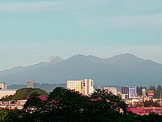
Mount Apo, also known locally as Apo Sandawa, is a large solfataric, dormant stratovolcano on the island of Mindanao, Philippines. With an elevation of 2,954 meters (9,692 ft) above sea level, it is the highest mountain in the Philippine Archipelago and is located between Davao City and Davao del Sur province in Region XI and Cotabato in Region XII. The peak overlooks Davao City 45 kilometers (28 mi) to the northeast, Digos 25 kilometers (16 mi) to the southeast, and Kidapawan 20 kilometers (12 mi) to the west. Mount Apo is a protected area and a Natural Park of the Philippines.

The Peñablanca Protected Landscape and Seascape is a protected area and national park in Peñablanca, Cagayan. It is on the border with Isabela province, contiguous with the Northern Sierra Madre Natural Park. The protected area, best known as the location of Callao Cave, covers the largest block of forest under conservation in the province. It covers 118,781.582 hectares of the northern Sierra Madre mountain range and its adjacent Pacific coast.
The Manleluag Spring Protected Landscape is a protected area containing natural hot springs in the Ilocos Region of the Philippines. It is one of 34 protected landscapes in the Philippines located in the municipality of Mangatarem, Pangasinan in the west-central area of the island of Luzon.

The Mount Timolan Protected Landscape is a protected area covering Mount Timolan and its surrounding forested landscape in the region of Zamboanga Peninsula on Mindanao in the Philippines. The park encompasses an area of 1,994.79 hectares and a buffer zone of 695.39 hectares in the municipalities of San Miguel, Guipos and Tigbao in the province of Zamboanga del Sur. It was established on 14 August 2000 through Proclamation Order No. 354 issued by President Joseph Estrada. The park was also earlier established by the provincial government of Zamboanga del Sur as a provincial park and wildlife sanctuary known as the Zamboanga del Sur Provincial Park through Provincial Ordinance No. 3 in 1992.

The Libunao Protected Landscape, also known as the Libunao Spring Protected Landscape, is a protected area in the Ilocos Region of the island of Luzon in the Philippines located on the western foothills of the Ilocos Mountain Range. It protects the Libunao Spring and surrounding forests, as well as the Nagcullooban River watershed. First proclaimed as the Libunao Spring Watershed Forest Reserve in 1931 through Proclamation No. 410 issued by Governor-General Dwight F. Davis, the park was reestablished as a protected landscape area under the National Integrated Protected Areas System in 2000 through Proclamation No. 280 signed by President Joseph Estrada. The Libunao watershed is the source of water supply for domestic use and irrigation of the surrounding farms and communities of northern Ilocos Sur province.
The Santa Lucia Protected Landscape, also known as the Salcedo Protected Landscape, is a protected area located in the foothills of the Cordillera Central mountain range in the Ilocos Sur province of the Philippines. It protects an important watershed that serves as the water source for the surrounding communities in the municipality of Salcedo. It had an initial area of 174 hectares proclaimed as the Santa Lucia Watershed Forest Reserve in 1938 through Proclamation No. 333 issued by President Manuel Luis Quezon. In 2000, the forest reserve was reestablished as a protected landscape area under the National Integrated Protected Areas System with the signing of Proclamation No. 296 by President Joseph Estrada.

The Rajah Sikatuna Protected Landscape is a protected landscape area of forested limestone hills, grasslands and natural springs in the island province of Bohol in the Central Visayas region of the Philippines. It is the largest remaining tract of natural forest in Bohol and one of the Philippines' top birdwatching sites. The park was initially gazetted a national park in 1987 covering approximately 9,023 hectares. In 2000, it was reestablished as a protected landscape under the National Integrated Protected Areas System covering its present area of 10,452.6 hectares. The park is one of the island's major tourist attractions located just south of the famous Chocolate Hills. It was named after the Bohol chieftain who entered into a blood-compact with Spanish conquistador Miguel López de Legazpi on the island in 1565.

Pujada Bay, sometimes called Pujaga Bay, is a bay on the Pacific coast of the southern Philippine island of Mindanao. It is an arm of the Philippine Sea in Davao Oriental province formed by the Guanguan Peninsula which separates it from the Mayo Bay on the east and the Pujada Peninsula which separates it from the Davao Gulf on the west. Pujada Bay borders Mati, the province's capital and largest city, with its port and city proper situated at its head. It is entered between Lamigan Point on the east and Tumago Point on the west, with the Pujada Island dividing its entrance into two channels. There are three other islands on the bay, namely Uanivan, Oak and Ivy islands.

The Aliwagwag Protected Landscape is a protected area that preserves a major drainage catchment in the southern Philippine island of Mindanao in the Davao Region. It contains the headwaters of the Cateel River in the southern Diuata Mountain Range which provides the water source and irrigation for surrounding rice fields and communities in Davao de Oro and Davao Oriental provinces. It was named after the remote rural village in the municipality of Cateel where Aliwagwag Falls, the country's highest waterfall, is located.

The Pasonanca Natural Park is a protected area that preserves a major watershed in the southern Philippine island of Mindanao in the Zamboanga Peninsula. It contains the headwaters of the Tumaga River in the southern Zamboanga Cordillera mountain range that serves the water requirements of some 800,000 residents in Zamboanga City. It was named after the village of Pasonanca located in the city's northern fringes where the Pasonanca Park, a public eco-park, and the Abong-Abong Park, a pilgrimage site, can also be found.
The Mainit Hot Springs Protected Landscape is a protected landscape area located in the province of Davao de Oro on the island of Mindanao in the Philippines. It preserves the sulfuric hot springs and surrounding forest in Nabunturan municipality which also contains the headwaters of the Manat River, a source of water supply for surrounding villages. First declared a national park in 1957 by virtue of Proclamation No. 466 by President Carlos P. Garcia, it had an initial area of 1,381 hectares. Under the National Integrated Protected Areas System, it was reclassified as a protected landscape through Proclamation No. 320 issued in 2000 by President Joseph Estrada. The hot springs are a popular ecotourist attraction in Davao de Oro. Its name "Mainit" is a Filipino word which means hot.
The Maulawin Spring Protected Landscape is a protected landscape area of forested hills and several rivers and streams located in the province of Quezon on southern Luzon island in the Philippines. It was originally created in 1939 to protect the watershed in the municipality of Guinayangan known as the Maulawin Spring Watershed Forest Reserve declared through Proclamation No. 365 by President Manuel Luis Quezon. It had an initial area of 60 hectares. In 2000, the forest reserve was enlarged and was redesignated as a protected landscape under the National Integrated Protected Areas System by virtue of Proclamation No. 295 issued by President Joseph Estrada. It is the only source of potable water for domestic consumption of the more than 40,000 residents of Guinayangan.
The Buenavista Protected Landscape is a conservation area and an archaeological site located on Bondoc Peninsula in the southern Luzon province of Quezon in the Philippines. It conserves an important watershed area composed of secondary-growth forest, grassland and coconut land in the rural village of Buenavista within the coastal municipality of Mulanay. The area was primarily set aside for watershed protection and timber production in 1937 covering approximately 356 hectares. In 2000, it was reestablished as a protected landscape area under the National Integrated Protected Areas System. The area is known as the site of an ancient village containing unique limestone graves discovered in 2011. The protected area, including the limestone tombs of Kamhantik were recommended by various scholars to be included in the tentative list of UNESCO World Heritage Sites, yet no government or private entities have yet to file a tentative nomination to the UNESCO Secretariat.

The Dinadiawan River Protected Landscape is a protected area covering the stretch of the Dinadiawan River from its headwaters in the Sierra Madre mountain range to its mouth on the Philippine Sea coast of the village of Dinadiawan in Aurora province, Philippines. The park covers an area of 3,371.332 hectares and includes its surrounding forested mountains, waterfalls and springs in Dipaculao municipality. It is composed of 2,645 hectares of forested area, 323 hectares of grassland, 151 hectares of forested shrubland, 144 hectares of cultivated area, and 108 hectares of the Dinadiawan River. Its forest cover consists primarily of dipterocarp trees like tanguile, mayapis, white lauan, red lauan and bagtikan. It serves as a habitat of wild fauna such as the Philippine deer, Philippine long-tailed macaque, Philippine warty pig, spotted wood kingfisher and pygmy swiftlet.
The Simbahan–Talagas Protected Landscape is a protected area in northern Aurora, Philippines that preserves a major watershed in the Sierra Madre mountain range of Central Luzon. It contains the headwaters of the Simbahan and Talagas rivers, including the Sangay River and Umihiem Creek in Dinalungan municipality which empty into the Casiguran Sound. A large portion of the park is under forest cover, while the remaining areas are cultivated land, shrubland, grassland, built-up area and river-wash area. Some of the park's fauna include the Philippine deer, Philippine long-tailed macaque, and an abundant species of avifauna. Its location in north central Sierra Madre is covered by dipterocarp forest, composed of Shorea almon, Shorea polysperma (tanguile), Shorea squamata (mayapis), Shorea contorta, Shorea negrosensis, and Parashorea malaanonan (bagtikan).
The Calbayog Pan-as–Hayiban Protected Landscape, also known as the Calbayog Watershed, is a watershed and protected area located northwest of the city of Calbayog, Province of Samar in Oquendo District between Tinambacan District and San Isidro, Northern Samar in the Philippines. It is a mountainous region in the Tanaoan Ridge within the Mount Zamal Range that divides the three provinces of Samar. The protected area extends along the valley of the Hayiban River, the primary source of water for the Calbayog Water District. It consists of old growth trees and a system of rivers, waterfalls and streams capable of generating 2,279 liters per day. It also contains the Pan-as Falls and surrounding landscape which also supplies hydroelectric power to the city. The area was declared a forest reserve in 1967 known as the Pan-as Falls–Hayiban Watershed Forest Reserve with a total area of 7,832 hectares. In 1998, through Proclamation No. 1158 issued by President Fidel Ramos, the watershed was reclassified as a protected landscape. It is one of four protected areas in the island of Samar.
The Baganga Protected Landscape, in Mindanao in the Philippines, is one of four protected watershed areas of the province of Davao Oriental. It covers the Upper Baganga River Basin in the Mindanao Pacific Cordillera, the primary source of water for the Baganga Water District. The Baganga River, the main river channel of the municipality of Baganga, flows on a northeastern direction towards the Baganga Bay. The river system includes the Languyon River, Daquit River, Mahanob River, Dapnan River and Kinablang River all emptying into the Philippine Sea. It was established in 1987 as the Baganga Watershed Forest Reserve with an area of 114 hectares. The watershed was declared a protected landscape in 2000.
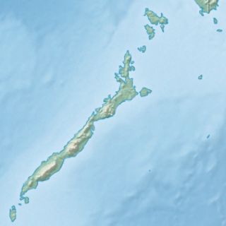
Malampaya Sound is a protected inlet of the South China Sea on the northwestern coast of Palawan Island in western Philippines. It is a geographic sound consisting of a complex of sheltered bays, coves, estuaries and islands separated from the sea to the west by the Copoas Peninsula. The sound is within the municipality of Taytay and is an important feature for the ecology and economy of the province of Palawan. It is considered one of the finest natural harbors in the Philippines and one of Palawan's richest fishing grounds.
The Mabini Protected Landscape and Seascape, in Davao de Oro, Philippines, is a terrestrial and marine protected area established in 2000 to protect ecologically significant habitats in the Davao Gulf. The park extends along the coast of the municipality of Mabini from the mouth of the Pandasan River to the southern tip of Kopiat Island. It also includes Lunod Island, also known as Pandasan Island, which was earlier declared a wilderness area in 1981. It covers 6,106 hectares of extensive mangrove forests, white sand beaches and rich coral reef systems.

The Angat Watershed Forest Reserve is a conservation area that protects the drainage basin in the southern Sierra Madre range north of Metro Manila in the Philippines where surface water empties into the Angat River and its tributaries. It is spread over an area of 62,309 hectares in the eastern portion of Bulacan and northern Rizal province at an altitude of between 490 and 1,206 metres. The conservation area also extends to the provinces of Nueva Ecija and Quezon and is centered on an artificial lake created by the Angat Dam which, together with the Ipo Dam located 7.5 kilometres (4.7 mi) downstream, supply 97% of the water requirement of Metro Manila via an aqueduct system to the La Mesa Dam and Reservoir and the Balara Filtration Plant in Quezon City. The Angat Dam and Reservoir is also a major source of hydroelectricity for Metro Manila and surrounding provinces, contributing some 200 megawatts to the Luzon grid. The watershed is a popular birdwatching site and is a biodiversity hotspot containing most of the remaining closed-canopy forests in Central Luzon.
