Mindanao is the second-largest island in the Philippines, after Luzon, and seventh-most populous island in the world. Located in the southern region of the archipelago, the island is part of an island group of the same name that also includes its adjacent islands, notably the Sulu Archipelago. According to the 2020 census, Mindanao had a population of 26,252,442, while the entire island group had an estimated population of 27,021,036.

The Philippines is an archipelago that comprises 7,641 islands, and with a total land area of 300,000 square kilometers (115,831 sq mi), it is the world's fifth largest island country. The eleven largest islands contain 95% of the total land area. The largest of these islands is Luzon at about 105,000 square kilometers (40,541 sq mi). The next largest island is Mindanao at about 95,000 square kilometers (36,680 sq mi). The archipelago is around 800 kilometers (500 mi) from the Asian mainland and is located between Taiwan and Borneo.

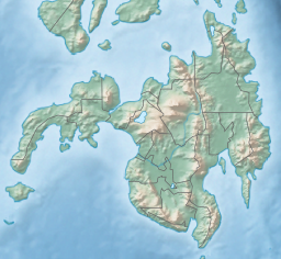
Zamboanga del Sur, officially the Province of Zamboanga del Sur, is a province in the Philippines located in the Zamboanga Peninsula region in Mindanao. Its capital is the city of Pagadian.
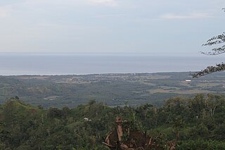
The Moro Gulf is the largest gulf in the Philippines. It is located off the coast of Mindanao Island, and is part of the Celebes Sea. The gulf is one of the country's tuna fishing grounds.

Lanao del Sur, officially the Province of Lanao del Sur, is a province in the Philippines located in the Bangsamoro Autonomous Region in Muslim Mindanao (BARMM). The capital is the city of Marawi, and it borders Lanao del Norte to the north, Bukidnon to the east, and Maguindanao del Norte and Cotabato to the south. To the southwest lies Illana Bay, an arm of the Moro Gulf.
Soccsksargen, formerly known as Central Mindanao, is an administrative region of the Philippines, designated as Region XII. Located in south-central Mindanao, its name is an acronym that stands for the region's four provinces and one highly urbanized city. The regional center is in Koronadal, located in the province of South Cotabato, and the center of commerce and industry is General Santos, which is the most populous city in the region.

Pagadian, officially the City of Pagadian, is a 1st class component city and the capital of the province of Zamboanga del Sur, Philippines. It is the regional center of Zamboanga Peninsula and the second-largest city in the region and in the province, after the independent city of Zamboanga. According to the 2020 census, it has a population of 210,452 people. The city will be converted to a highly urbanized city by the virtue of Proclamation No. 1247, signed by President Rodrigo Duterte dated November 8, 2021.

The Rio Grande de Mindanao, also known as the Mindanao River, is the second-largest river system in the Philippines. Located on the southern island of Mindanao, with a total drainage area of 23,169 km2 (8,946 sq mi), draining the majority of the central and eastern portion of the island, and a total length of approximately 373 km (232 mi). It is an important transportation artery, used mainly in transporting agricultural products and, formerly, timber.

Tabina, officially the Municipality of Tabina, is a 4th class municipality in the province of Zamboanga del Sur, Philippines. According to the 2020 census, it has a population of 25,734 people.

Tukuran, officially the Municipality of Tukuran, is a 4th class municipality in the province of Zamboanga del Sur, Philippines. According to the 2020 census, it has a population of 42,429 people.
Olutanga is a Philippine island in the Moro Gulf, part of Zamboanga Sibugay Province. It is separated from the Zamboanga Peninsula by a narrow channel and Tantanang Bay.

Rice and beans, or beans and rice, is a category of dishes from many cultures around the world, whereby the staple foods of rice and beans are combined in some manner. The grain and legume combination provides several important nutrients and many calories, and both foods are widely available. The beans are usually seasoned, while the rice may be plain or seasoned. The two components may be mixed together, separated on the plate, or served separately.

The Battle of Mindanao was fought by the Americans and allied Filipino guerrillas against the Japanese forces on the island of Mindanao in the Philippines as part of Operation VICTOR V. It was part of the campaign to liberate the Philippines during World War II. The battle was waged to complete the recapture of the southernmost portions of the archipelago from the Imperial Japanese Army.

The Sultanate of Maguindanao was a Sunni Muslim sultanate that ruled parts of the island of Mindanao, in the southern Philippines, especially in modern-day Maguindanao provinces, Soccsksargen, Zamboanga Peninsula and Davao Region. Its known historical influence stretches from the peninsula of Zamboanga to bay of Sarangani until Davao Gulf. During the era of European colonization, the sultanate maintained friendly relations with British and Dutch traders.

Sibuguey Bay is a large bay of the Moro Gulf, situated off the southwestern coast of Mindanao Island in the Philippines.
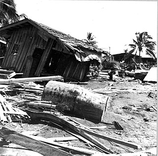
The 1976 Moro Gulf earthquake and tsunami occurred on near the islands of Mindanao and Sulu, in the Philippines. It measured 8.0 on the moment magnitude scale occurring at a depth of 20 km (12 mi). The earthquake was accompanied by a destructive tsunami that resulted in a majority of the estimated 5,000 to 8,000 fatalities. It was the deadliest and strongest earthquake in the Philippines in 58 years since the 1918 Celebes Sea earthquake.
The 2010 Mindanao earthquakes occurred in the southern Philippines in the Moro Gulf. This was a complex sequence of events including three main events of magnitude 7.3 or greater on the 23rd of July, and two significant aftershocks of magnitude 6.6 on the 24th and 29th. All of these were deep focus earthquakes, at depths from 565 km (351 mi) to 634 km (394 mi). This resulted in minimal, but very widespread shaking at the surface, with a maximum intensity of IV on the PEIS scale; consequently there were no reports of casualties or damage.

The Spanish–Moro conflict was a series of battles in the Philippines lasting several centuries. It began during the Spanish Philippines and lasted until the Spanish–American War, when Spain finally began to subjugate the Moro people after centuries of attempts to do so. Spain ultimately conquered portions of the Mindanao and Jolo islands and turned the Sultanate of Sulu into a protectorate, establishing geographic dominance over the region until the Spanish-American War. Moro resistance continued.

The 1918 Celebes Sea earthquake occurred on August 15 at 12:18 UTC near the Moro Gulf coast of Mindanao. It had a magnitude of 8.3 on the moment magnitude scale and a maximum perceived intensity of X (Extreme) on the Mercalli intensity scale. It triggered a tsunami of up to 7 m in height and the combined effects of the earthquake and tsunami led to the deaths of 52 people.