Leyte is an island in the Visayas group of islands in the Philippines. It is eighth-largest and sixth-most populous island in the Philippines, with a total population of 2,626,970 as of 2020 census.

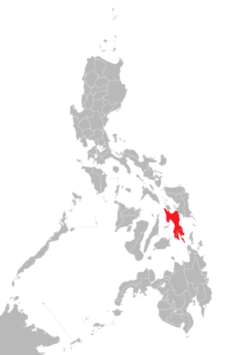
Leyte, officially the Province of Leyte, is a province in the Philippines located in the Eastern Visayas region occupying the northern three-quarters of Leyte Island. Its capital is the city of Tacloban, administered independently from the province, as well as the regional center of Eastern Visayas. Leyte is thus north of Southern Leyte, south of Biliran, and west of Samar Island. To the west across the Camotes Sea is the province of Cebu.

Tacloban, officially the City of Tacloban, is a highly urbanized city on Leyte island in the Eastern Visayas region of the Philippines. According to the 2020 census, Tacloban has a population of 251,881, making it the most populous city in the Eastern Visayas. The city is located 360 miles (580 km) southeast of Manila.

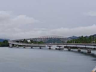
The San Juanico Bridge is part of the Pan-Philippine Highway and stretches from Samar to Leyte across the San Juanico Strait in the Philippines. Its longest length is a steel girder viaduct built on reinforced concrete piers, and its main span is of an arch-shaped truss design. Constructed during the administration of President Ferdinand Marcos through Japanese Official Development Assistance loans, it has a total length of 2.16 kilometers (1.34 mi)—the third longest bridge spanning a body of seawater in the Philippines after the Panguil Bay Bridge. It was also the longest bridge in the Philippines upon its opening in 1973, surpassed in 1976 by Candaba Viaduct of North Luzon Expressway (NLEX), another bridge that connects from one province to another, connecting the provinces of Pampanga and Bulacan.
Palo, officially the Municipality of Palo, is a First Income Class municipality in the province of Leyte, Philippines. According to the 2020 census, it has a population of 76,213 people, making it the most populous municipality (non-city) in the province.

Daniel Z. Romualdez Airport, also known as Tacloban City Airport, is an airport serving the general area of Tacloban, a highly urbanized city in the Leyte island of the Philippines. It is the main gateway from Manila and Cebu to Eastern Visayas. It is classified as a Class 1 principal airport by the Civil Aviation Authority of the Philippines. In 2022, Daniel Z. Romualdez Airport served 1.48 million passengers, making it the seventh-busiest in the country.

Carlos Jericho "Icot" Loreto Petilla is a Filipino politician. He ran as a senator under the Liberal Party during the 2016 Philippine general election. A former Secretary of Energy during the administration of Benigno Aquino III, he is currently serving as Governor of Leyte since 2022 and previously from 2004 to 2012.

The Cebu Provincial Capitol is the seat of the provincial government of Cebu in the Philippines. Located at the north end of Osmeña Boulevard in Cebu City, it was designed by Juan M. Arellano, a Filipino architect best known for the Manila Metropolitan Theater (1935), the Legislative Building, and the Manila Central Post Office (1926). An inscription on the central concave portion of its façade reads, "The authority of the government emanates from the people. Erected A.D. MCMXXXVII."

Typhoon Haiyan, known in the Philippines as Super Typhoon Yolanda, was one of the most powerful tropical cyclones ever recorded. Upon making landfall, Haiyan devastated portions of Southeast Asia, particularly the Philippines. It is one of the deadliest typhoons on record in the Philippines, killing at least 6,300 people in the region of Visayas alone. In terms of JTWC-estimated 1-minute sustained winds, Haiyan is tied with Meranti in 2016 for being the second strongest landfalling tropical cyclone on record, only behind Goni of 2020. Haiyan was also the most intense tropical cyclone worldwide in 2013.

The MacArthur Leyte Landing Memorial National Park is a protected area of the Philippines that commemorates the historic landing of General Douglas MacArthur in Leyte Gulf at the start of the campaign to recapture and liberate the Philippines from Japanese occupation on 20 October 1944. This event led to the largest naval battle of World War II and Japan's eventual defeat and surrender after almost three years. The war memorial is located in the municipality of Palo on Leyte island in Eastern Visayas and is one of the region's major tourist attractions. It was declared a national park on 12 July 1977 through Letter of Instructions No. 572 signed by President Ferdinand Marcos.

Pope Francis made a pastoral and state visit to the Philippines from January 15 to 19, 2015. He was the third pontiff to visit the Philippines after Paul VI in 1970 and John Paul II in 1981 and 1995, officially the first papal visit in the 21st century and 3rd millennium after the title was originally scheduled for World Meeting of Families twelve years earlier in 2003 but postponed due to John Paul II was unable to attend because of the progression of his Parkinson's disease, and fourth papal visit to the country overall. Besides Manila, Francis visited Tacloban and Palo, Leyte, to encourage the victims of Typhoon Haiyan (Yolanda) and Typhoon Hagupit (Ruby). The Filipinos nicknamed Francis Lolo Kiko as a term of endearment, which he commended. Around 6–7 million attended Francis' final Papal Mass at Luneta, surpassing the crowd at World Youth Day 1995 in the same venue and making it the largest papal crowd in history. The theme of Francis' 2015 visit was "Mercy and Compassion".

Casa Real is one of the oldest public buildings and served as the provincial seat of government of Lingayen, Pangasinan, in the Philippines during the Spanish colonial period. It was where the alcalde mayor held office as the provincial governor and the judge of the Court of First Instance. It was declared a National Landmark by the National Historical Commission of the Philippines and noted it as "an outstanding and unique example of civil architecture from the Spanish and American colonial periods". Local offices that were housed by the building abandoned it when Typhoon "Cosme" ripped off its roof in 2008. Since 2023, the building houses the Banaan Pangasinan Provincial Museum.

The Leyte Provincial Board is the Sangguniang Panlalawigan of the Philippine province of Leyte.
Eastern Visayas is an administrative region in the Philippines, designated as Region VIII. It consists of three main islands: Samar, Leyte, and Biliran. The region has six provinces: Biliran, Leyte, Northern Samar, Samar, Eastern Samar, Southern Leyte, one independent city, Ormoc, and one highly urbanized city, Tacloban. The highly urbanized city of Tacloban is the sole regional center. These provinces and cities occupy the easternmost islands of the Visayas group of islands, hence the region's name. Some historians believe that the oldest ancient kingdom in the Philippines is found in this region, the Lakanate of Lawan, which plays a significant role in the Polynesian and Austronesian intermigration.
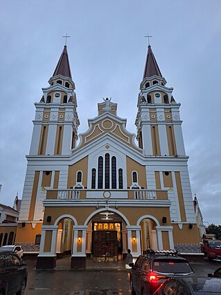
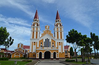
The Metropolitan Cathedral of Our Lord's Transfiguration, also known as Transfiguration of Our Lord's Cathedral or simply Palo Cathedral, is a Roman Catholic church located at Palo, Leyte, in the Philippines belonging to the Vicariate of Palo under the Metropolitan Archdiocese of Palo.
Atty. Carlo Petilla Loreto is the former vice governor of Leyte from 2013 until 2022. He is a lawyer by profession and is an advocate of environmental and humanitarian concerns. He is also the national vice-president in the League of Vice-Governors of the Philippines (LVGP) for Visayas. He is the former national president in the Provincial Board Members League of the Philippines and national secretary general of the National Movement of Young Legislators (NYML). He also holds various positions in different organizations and committees.
The 2019 Eastern Samar Earthquake struck the islands of Visayas in the Philippines on April 23, 2019, at 1:37:51 p.m. (PST). It had a moment magnitude of 6.5 and a local magnitude of 6.2 with a max intensity of VI based on the PHIVOLCS earthquake intensity scale (PEIS). The epicenter was in San Julian, Eastern Samar and the hypocenter was at a depth of 64 km(~39.76 mi). As of April 30, 2019 there were 172 aftershocks ranging from magnitudes of 1.6 to 4.6. The earthquake injured 48 people and damaged about 245 homes.

Typhoon Phanfone, known in the Philippines as Typhoon Ursula, was a strong and deadly tropical cyclone which traversed the Philippines on Christmas Eve and Christmas Day in 2019, the first typhoon to do so since Nock-ten in 2016.
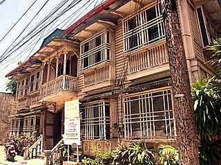
The Redoña Residence was a historic house along T. Claudio Street in Tacloban, Philippines.


