Buntun Bridge

Last updated • 3 min readFrom Wikipedia, The Free Encyclopedia

17°36′49″N121°41′29″E / 17.61361°N 121.69139°E / 17.61361; 121.69139

Contents

Buntun Bridge
Buntun Bridge from Tuguegarao City, Mar 2024.jpg
Coordinates 17°36′49″N121°41′29″E / 17.6136°N 121.6914°E / 17.6136; 121.6914
Carries2 lanes of N51 (Philippines).svg N51 (Santiago–Tuguegarao Road); pedestrian sidewalks
Crosses Cagayan River
Locale Tuguegarao City, Cagayan (North)
Solana, Cagayan (South)
Official nameBuntun Bridge
Other name(s)Talletay ta Buntun
Maintained by Department of Public Works and Highways – Cagayan 3rd District Engineering Office
Characteristics
DesignSteel truss bridge [1]
Material Steel, Concrete, Asphalt
Total length1,369 m (4,491 ft) [a]
Width9.60 m (31 ft) [2]
Height37 m (121 ft)
No. of spans14
Load limit18 t (18,000 kg)
Clearance above 6 m (20 ft)
History
Constructed by Philippine National Construction Corporation
Construction startDecember 11, 1960 [1]
Construction endMay 10, 1969
OpenedJune 1, 1969
Statistics
TollNo
Location
Buntun Bridge

Buntun Bridge (Itawit : Talletay ta Buntun; Ilocano : Rangtáy ti Buntun; Filipino : Tulay ng Buntun) is a river bridge that stretches from Tuguegarao City to Solana in Cagayan and spans the Cagayan River, the largest river basin in the Philippines. [3] It forms part of the Santiago–Tuguegarao Road (designated as N51 by the Department of Public Works and Highways highway routing system), a major junction of the Pan-Philippine Highway. It was the longest bridge in the Philippines upon its opening in 1969, surpassed in 1973 by the San Juanico Bridge.

A popular belief is that the bridge is long enough for a person to recite the entire Philippine National Anthem while traversing. [4]

History

In 1959, President Carlos P. Garcia released 200,000 to start the construction of the bridge. The meager amount was augmented in several appropriations embodied in different Republic Acts through the initiative of Cagayan's 2nd District Congressman Benjamin Ligot. The ground-breaking ceremony on December 11, 1960, was attended by President Garcia. [1]

Construction

The construction was based from the original plan of ten 240-foot (73 m) steel through truss spans and one 50-foot (15 m) I-beam approach on each end. With the initial 200,000, Angeleo Alonzo, the first District Engineer of Department of Public Works, Transportation and Communications 2nd Cagayan Engineering District, completed Abutment A. Pier I, footing and pedestal of Pier II.

In 1962, however, Diosdado Macapagal took over as President and no one knew whether or not he would continue the project. Congressman Ligot convinced the President to continue the project under one AGUID Construction Company. The frequent floods have widened the river channel and caused the change of plan for the bridge to 14 240-foot (73 m) Japanese steel through truss spans and one 50-foot (15 m) I-beam approach on the Solana side.

President Ferdinand Marcos ordered Public Works, Transportation and Communications Secretary Antonio Raquiza to assign the bureau's construction team led by Engineer Rogelio Talastas to Buntun Bridge. The team, under Alonzo's general supervision, went to work in full swing in May 1968.

By May 10 the following year, the bridge was practically completed. However, the construction team was transferred to another project, leaving Alonzo to complete the painting of the landmark structure and the construction of the grouted riprap and the road approaches. [1]

First Lady Imelda Marcos opened the bridge to vehicular traffic on June 1, 1969, which took three administrations to build. [1]

Features

Buntun Bridge serves as the gateway to the Cagayan's provincial capital, Tuguegarao City and links to the second and third district municipalities of Cagayan and Apayao. [5] The road infrastructure measures 1,369 m (4,491 ft), [a] considered the longest river bridge in the Philippines. It has 14 Japanese steel spans. The bridge offers an unobstructed, picturesque view of the Cagayan River, [6] the widest and longest river in the country.

The bridge is also utilized as a monitoring point for water levels along the Cagayan River, particularly during floods. [7]

Congestion issues

Due to its location on a major thoroughfare linking Tuguegarao and Solana, the bridge has become a major chokepoint for traffic between the two localities, prompting the construction of additional bridges along the Cagayan River. [8]

See also

Notes

  1. 1 2 There are inconsistencies regarding the actual length of the bridge. Numerous sources cite 1,098 m (3,602 ft) as the bridge's official length. On the other hand, the 1,369 m (4,491 ft) length was retrieved from the information indicated in the bridge itself.

Related Research Articles

<span class="mw-page-title-main">Cagayan River</span> Longest river in the Philippines

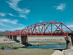
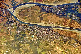
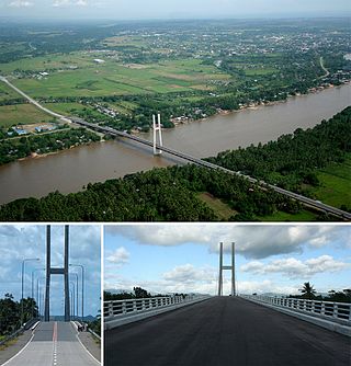
The Cagayan River, also known as the Río Grande de Cagayán, is the longest river and the largest river by discharge volume of water in the Philippines. It has a total length of approximately 505 kilometres (314 mi) and a drainage basin covering 27,753 square kilometres (10,715 sq mi). It is located in the Cagayan Valley region in northeastern part of Luzon Island and traverses the provinces of Nueva Vizcaya, Quirino, Isabela and Cagayan.

<span class="mw-page-title-main">Cagayan Valley</span> Administrative region of the Philippines

Cagayan Valley, designated as Region II, is an administrative region in the Philippines. Located in the northeastern section of Luzon, it is composed of five Philippine provinces: Batanes, Cagayan, Isabela, Nueva Vizcaya, and Quirino. The region hosts four chartered cities: Cauayan, Ilagan, Santiago, and Tuguegarao.

<span class="mw-page-title-main">Cagayan</span> Province in Cagayan Valley, Philippines

Cagayan, officially the Province of Cagayan, is a province in the Philippines located in the Cagayan Valley region, covering the northeastern tip of Luzon. Its capital is Tuguegarao, the largest city of that province as well as the regional center of Cagayan Valley. It is about 431 kilometres (268 mi) northwest of Manila, and includes the Babuyan Islands to the north. The province borders Ilocos Norte and Apayao to the west, and Kalinga and Isabela to the south.

<span class="mw-page-title-main">San Juanico Bridge</span> Third longest bridge in the Philippines, connecting Leyte and Samar

The San Juanico Bridge is part of the Pan-Philippine Highway and stretches from Samar to Leyte across the San Juanico Strait in the Philippines. Its longest length is a steel girder viaduct built on reinforced concrete piers, and its main span is of an arch-shaped truss design. Constructed during the administration of President Ferdinand Marcos through Japanese Official Development Assistance loans, it has a total length of 2.16 kilometers (1.34 mi)—the third longest bridge spanning a body of seawater in the Philippines after the Panguil Bay Bridge. It was also the longest bridge in the Philippines upon its opening in 1973, surpassed in 1976 by Candaba Viaduct of North Luzon Expressway (NLEX), another bridge that connects from one province to another, connecting the provinces of Pampanga and Bulacan.

<span class="mw-page-title-main">Enrile, Cagayan</span> Municipality in Cagayan, Philippines

Enrile, officially the Municipality of Enrile, is a municipality in the province of Cagayan, Philippines. According to the 2020 census, it has a population of 36,705 people.

<span class="mw-page-title-main">Santa Praxedes, Cagayan</span> Municipality in Cagayan, Philippines

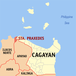
Santa Praxedes, officially the Municipality of Santa Praxedes, is a municipality in the province of Cagayan, Philippines. According to the 2020 census, it has a population of 4,434 people, making it the least populated municipality in the province.

<span class="mw-page-title-main">Solana, Cagayan</span> Municipality in Cagayan, Philippines

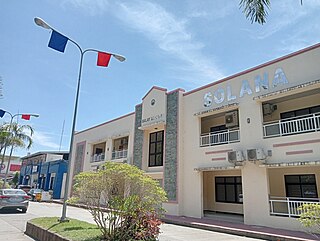
Solana, officially the Municipality of Solana, is a municipality in the province of Cagayan, Philippines. According to the 2020 census, it has a population of 88,445 people.

<span class="mw-page-title-main">Pan-Philippine Highway</span> Highway in the Philippines traversing most of the country

The Pan-Philippine Highway, also known as the Maharlika Highway, is a network of roads, expressways, bridges, and ferry services that connect the islands of Luzon, Samar, Leyte, and Mindanao in the Philippines, serving as the country's principal transport backbone. Measuring 3,379.73 kilometers (2,100.07 mi) long excluding sea routes not counted by highway milestones, it is the longest road in the Philippines that forms the country's north–south backbone component of National Route 1 (N1) of the Philippine highway network. The entire highway is designated as Asian Highway 26 (AH26) of the Asian Highway Network.

<span class="mw-page-title-main">Outline of the Philippines</span> Overview of and topical guide to the Philippines

The following outline is provided as an overview of and topical guide to the Philippines:

<span class="mw-page-title-main">Magat Dam</span> Dam in Luzon, Philippines

Magat Dam is a large rock-fill dam in the island of Luzon in the Philippines. The dam is located along the Magat River, a major tributary of the Cagayan River. The construction of the dam started in 1975 and was completed in 1982. It is one of the largest dams in the Philippines. It is a multi-purpose dam which is used primarily for irrigating about 85,000 hectares of agricultural lands, flood control, and power generation through the Magat Hydroelectric Power Plant.

<span class="mw-page-title-main">Roman Catholic Archdiocese of Tuguegarao</span> Roman Catholic archdiocese in the Philippines

The Roman Catholic Archdiocese of Tuguegarao is a Latin Church metropolitan archdiocese of the Catholic Church in the Philippines. Tuguegarao is a river delta city that became center of the archdiocese in the province of Cagayan, on the island of Luzon. Its seat is located at the Saint Peter the Apostle Metropolitan Cathedral.

<span class="mw-page-title-main">Kettle Falls Bridges</span> Bridge in Kettle Falls, Washington

The Kettle Falls Bridges is the collective name for a pair of steel cantilever bridges carrying State Route 20/U.S. Route 395 and the Kettle Falls International Railway across the Columbia River at Kettle Falls, Washington. The south bridge carries motor vehicle traffic while the similar northern span is used for rail.

<span class="mw-page-title-main">Sergio Utleg</span> Roman Catholic archbishop-emeritus

Sergio Lasam Utleg, is a prelate of the Roman Catholic Church in the Philippines. He is the former Archbishop of Tuguegarao in Tuguegarao, Philippines. On October 18, 2019, his resignation was accepted by Pope Francis, appointing Alaminos Bishop Ricardo Baccay as his successor.

<span class="mw-page-title-main">Sargent Bridge</span> United States historic place

Sargent Bridge was a Pratt through truss steel bridge that spanned the Middle Loup River near Sargent, Nebraska. In 1992, it was listed in the National Register of Historic Places, as one of the few remaining steel truss bridges constructed in Nebraska during the early 20th century. It was destroyed by flooding in 2019, and was delisted in 2020.

<span class="mw-page-title-main">Tuguegarao</span> Capital of Cagayan, Philippines

Tuguegarao, officially the City of Tuguegarao, is a 1st class component city and capital of the province of Cagayan, Philippines. According to the 2020 census, it has a population of 166,334 people, making it the most populous city in Cagayan Province, Cagayan Valley and Northeastern Luzon.

<span class="mw-page-title-main">SM Center Tuguegarao Downtown</span> Shopping mall in the Philippines

SM Center Tuguegarao Downtown is a shopping mall owned and operated by SM Prime Holdings, the largest mall operator in the Philippines, located in the city's business district along Luna St. cor. Mabini St., Tuguegarao City, Cagayan. Opened on October 12, 2017, it is the first SM Supermall in Cagayan, the second in Cagayan Valley and the 65th in the Philippines. Also the seventh SM Mall under the "Center" brand, it has a gross floor area of 33,301 m2 (358,450 sq ft).

<span class="mw-page-title-main">Binondo–Intramuros Bridge</span> Bridge in Manila, Philippines

The Binondo–Intramuros Bridge is a tied-arch bridge in Manila, Philippines, spanning the Pasig River. It connects Muelle de Binondo in Binondo and San Nicolas to Solana Street and Riverside Drive in Intramuros. The bridge has four lanes and exhibits a steel bowstring arch design with inclined arches. It is 680 meters (2,230 ft) long.

<span class="mw-page-title-main">Santiago–Tuguegarao Road</span> National road in the Philippines

Santiago–Tuguegarao Road is a major national primary road in the provinces of Cagayan, Kalinga, and Isabela in the Philippines. It is a bypass road of the Pan-Philippine Highway, also known as Cagayan Valley Road, connecting to the cities of Tuguegarao and Santiago.

<span class="mw-page-title-main">Macapagal Bridge</span> Bridge in Butuan, Agusan del Norte

Macapagal Bridge is a steel cable-stayed bridge along Mayor Democrito D. Plaza II Avenue in Butuan, Agusan del Norte that crosses the Agusan River. It has a length of 908 m (2,979 ft), making it the second-longest bridge in Mindanao after Panguil Bay Bridge, and the third-longest cable-stayed bridge in the Philippines after the Marcelo Fernan Bridge and Cebu-Cordova Bridge.

<span class="mw-page-title-main">Cagayan Valley Road</span> Road in the Philippines

Cagayan Valley Road is a 121.216-kilometer (75.320 mi) major highway that connects the cities and municipalities of the province of Cagayan, Philippines.

References

  1. 1 2 3 4 5 De Yro, Benjie (October 29, 2016). "Buntun, the bridge 3 presidents built". The Northern Forum. Retrieved October 29, 2016.
  2. "Road and Bridge Inventory". Department of Public Works and Highways. Retrieved March 6, 2022.
  3. "Buntun Bridge". lakbaypinas.ph. Archived from the original on April 16, 2013. Retrieved January 27, 2022.
  4. "Buntun Bridge, the longest river bridge in the Philippines". www.dangerousroads.org.
  5. "Buntun Bridge – Tuguegarao City | Out and About – DiscoverPh.com". Archived from the original on June 16, 2012. Retrieved November 17, 2012.
  6. "Longest in the Philippines". Archived from the original on November 27, 2012. Retrieved November 19, 2012.
  7. "Tuguegarao exec urges preemptive evac in flood-prone villages". Philippine News Agency. Retrieved December 25, 2024.
  8. "Steel craneway ng Tuguegarao-Solana Bridge, pormal ng binuksan bilang alternatibong ruta sa mahigit 50-taong gulang na Buntun Bridge". Bombo Radyo. Retrieved December 25, 2024.