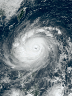
Meteorological history | |
---|---|
Formed | October 14,2016 |
Extratropical | October 22,2016 |
Dissipated | October 26,2016 |
Violent typhoon | |
10-minute sustained (JMA) | |
Highest winds | 215 km/h (130 mph) |
Lowest pressure | 900 hPa (mbar);26.58 inHg |
Category 5-equivalent super typhoon | |
1-minute sustained (SSHWS/JTWC) | |
Highest winds | 270 km/h (165 mph) |
Lowest pressure | 914 hPa (mbar);26.99 inHg |
Overall effects | |
Fatalities | 19 total |
Damage | $972 million (2016 USD) |
Areas affected | Caroline Islands,Philippines,Taiwan,China (including South,Hong Kong and East),Japan |
IBTrACS | |
Part of the 2016 Pacific typhoon season |
Typhoon Haima,known in the Philippines as Super Typhoon Lawin,was the third most intense tropical cyclone worldwide in 2016. It was the twenty-second named storm and the eleventh typhoon of the annual typhoon season. Impacting the Philippines less than 3 days after Typhoon Sarika,Haima formed out of a tropical disturbance southwest of Chuuk on October 14,it developed into a tropical storm the next day. Steady strengthening occurred over the next day or two as it tracked westward towards the Philippines. After forming an eye shortly after it was upgraded to a typhoon,Haima began to rapidly strengthen and eventually became a super typhoon on October 18. It later attained its peak intensity as a Category 5-equivalent tropical cyclone before weakening slightly. Haima later made landfall in Peñablanca,Cagayan late on October 19 as a Category 4-equivalent storm. Rapid weakening occurred as it interacted with the landmasses until it entered the Southern China Sea as a weak typhoon. It formed a large ragged eye once again and remained steady in intensity until making landfall in China on October 21. It weakened below typhoon intensity and became extratropical on October 22. The cyclone drifted northeastwards and later eastwards before emerging over water again,but eventually dissipated by October 26.
19 people were killed by Haima,and damage totals were estimated at more than US$970 million. The storm forced several hundred flights in the Philippines,Hong Kong and China to be cancelled. Ahead of the storm,several shelters were set up in the areas near China by the government to adequate the affected people Flooding and storm surge affected many coastal areas,downing several trees and power lines,leading to power outages. Due to the damage caused by the storm in the Philippines and China,the names Haima and Lawin were retired from their respective name lists in 2017.
During October 13, the United States Joint Typhoon Warning Center (JTWC) started to monitor a tropical disturbance, that had developed about 705 km (440 mi) to the south-southeast of the Anderson Air Force Base in Guam. [1] The system was located within a favourable environment for further development, with low vertical wind shear, warm sea surface temperatures and its dual outflow channels being enhanced by a TUTT Cell located to its northwest. [1] During that day, the system moved north-westwards under the influence of a subtropical ridge of high pressure to its north and rapidly developed a low level circulation center. [2] [3] During October 14, the JTWC and Japan Meteorological Agency (JMA) classified the disturbance as a tropical depression, while it was located within the Caroline Islands about 700 km (435 mi) to the south of Guam. [3] [4] [5] During that day, the depression’s low level circulation center continued to rapidly consolidate, while bands of atmospheric convection built and wrapped into the center. [3] As a result, both the JMA and JTWC reported that the depression had developed into a tropical storm, with the JMA naming it Haima after the Chinese word for a seahorse. [4] [6]
Immediately after the JMA indicated that Haima had intensified into a severe tropical storm at 00:00 UTC on October 16, the JTWC upgraded it to a typhoon because of improving banding; [7] [8] six hours later, the JMA also upgraded Haima to a typhoon, approximately 140 km (87 mi) northeast of Yap. [9] Tracking west-northwestward along a subtropical ridge to the north, Haima began to form an eye. [10] The typhoon entered the Philippine Area of Responsibility early on October 17 and received the name Lawin (hawk) from PAGASA, shortly before it deepened further with a sharply-outlined eye. [11] [12] Later, an eyewall replacement cycle occurred, as microwave satellite imagery revealed a solid inner ring of deep convection with a secondary outer ring. [13]
Haima completed the eyewall replacement cycle by the morning on October 18. At this time, the JTWC upgraded it to a super typhoon. [14] Several hours later, Haima presented a highly symmetric and tightly wound spiral structure with a 55 km (34 mi)-wide eye. There was a prominent anticyclone feature to the north blocking the usual poleward outflow channel, but given the impressive appearance, the restriction to flow was apparently having limited impact. [15] Located in an area of warm sea surface temperatures near 30 °C, Haima reached peak intensity at around 18:00 UTC, with the central pressure at 900 hPa (27 inHg) and ten-minute maximum sustained winds at 215 km/h (134 mph). [16] That intensity made Haima the second most intense tropical cyclone of the Northwest Pacific Ocean in 2016, after Typhoon Meranti. [17] Simultaneously, the JTWC estimated one-minute maximum sustained winds at 270 km/h (170 mph), equivalent to Category 5 on the Saffir–Simpson scale. [15] As Haima continued approaching and interacting with Luzon on October 19, the core convection became elongated with another eyewall replacement cycle, leading to a weakening trend and a cloud-filled eye. [18] The JTWC downgraded Haima to a Category 4-equivalent typhoon with 1-minute sustained winds of 220 km/h (140 mph). Subsequently, the system made landfall over Peñablanca, Cagayan of the Philippines at 23:00 PST (15:00 UTC). [19]
When Haima entered the South China Sea shortly before 08:00 PST (00:00 UTC) on October 20, the typhoon had weakened significantly but become larger. [20] Although Haima kept deteriorating gradually over decreasing ocean heat content, the system soon regained a ragged 150 km (93 mi)-wide eye. Environmental conditions at this time included increasing vertical wind shear slightly offset by good dual outflow channels. [21] Turning north-northwestward along the periphery of a subtropical ridge positioned to the north and east, Haima made landfall over Haifeng County, Shanwei in the Guangdong province of China at 12:40 CST (04:40 UTC) on October 21. [22] [23] Several hours later, Haima weakened into a severe tropical storm owing to the rugged terrain, and the JTWC issued its final warning on the system. [24] [25] The system further weakened into a tropical storm at 12:00 UTC and ultimately a tropical depression in the Jiangxi province at 18:00 UTC. [26] [27]
At around 08:00 CST (00:00 UTC) on October 22, Haima became extratropical and accelerated northeastward. [28] Emerging into Hangzhou Bay right before 20:00 CST (12:00 UTC), the low then entered the East China Sea and turned eastward. [29] [30] The system developed into a gale-force low near the Tokara Islands early on October 23. [31] Tracking eastward south of Japan, the system weakened into a low below gale-force about 420 km (260 mi) east of Chichijima, at around 09:00 JST (00:00 UTC) on October 25. [32] It then wandered around the area and dissipated early on October 26. [33]
During the passage of Haima, Signal 5 was given by the PAGASA. According to the National Disaster Risk Reduction and Management Council (NDRRMC), Haima killed 18 people in total, and damages had reached up to ₱3.74 billion (US$77.6 million). [34] [35]
PSWS# | Luzon | Visayas | Mindanao |
---|---|---|---|
5 | Cagayan, Isabela, Apayao, Kalinga, Northern Portion of Abra, Ilocos Norte | None | None |
4 | Ilocos Sur, Rest of Abra, Mt. Province, Ifugao, Calayan Group of Islands | None | None |
3 | La Union, Benguet, Nueva Vizcaya, Quirino, Northern Portion of Aurora | None | None |
2 | Batanes, Pangasinan, Rest of Aurora, Tarlac, Nueva Ecija, Northern Portion of Zambales, Northern Portion of Quezon including Polillo Island | None | None |
1 | Metro Manila, Rest of Zambales, Bulacan, Bataan, Pampanga, Rizal, Rest of Quezon, Cavite, Laguna, Batangas, Camarines Norte, Camarines Sur, Catanduanes, Albay | None | None |
The approach of Haima prompted the Hong Kong Observatory to issue the No. 8 Gale or Storm Signal; schools and businesses were suspended and roads and pavements empty as Haima passed as close as 110 km (68 mi) east-northeast of the city in the early afternoon of 21 October. “As the western part of Haima’s eyewall is rather close to Hong Kong, gales will affect the territory for some time,” said the observatory, warning the public to steer clear of the waterfront due to rough seas. However, many residents ignored the warning and watched the storm. Haima brought heavy rainfall and gusts of up to 105 kilometres per hour, as waves crashed over and flooded coastal roads and trees were knocked down by winds. Over 700 flights in and out of Hong Kong were cancelled, trading on the city's stock exchange was stopped on 21 October, and ferry services such as Hong Kong's famous cross-harbour Star Ferry were cancelled. All bus services were halted and underground metro trains were slowed. More than 20 shelters were set up by the government in preparation for the storm. [36] One person was killed and damages have totalled to HK$5 billion (US$644.7 million). [37]
The approach of Haima led to the Macau Meteorological and Geophysical Bureau issuing the No. 8 tropical cyclone signal at 08:30 local time for the first time in 2016. However, winds at Macau were much lighter than neighbouring Hong Kong, as the intense rainbands associated with Haima just missed the territory. The No. 3 signal was eventually issued to replace the No. 8 signal at 15:30. The SMG later explained that as Haima took on a more eastward track during the day on 21 October, the intense rainbands and associated gales that were forecast to affect Macau eventually did not impact the territory directly.
Total economic losses in South China were counted to be ¥1.69 billion (US$249.9 million). [38]
On October 26, PAGASA has announced that the name Lawin will be removed from their naming lists because it had caused over ₱1 billion in damages and had added to the damage caused by Typhoon Karen. [39] On January 17, 2017, PAGASA chose the name Leon to replace Lawin for the 2020 season.
During the 49th annual session of the ESCAP/WMO Typhoon Committee in 2017, they announced that the name Haima will be removed from the naming lists. In March 2018, the Typhoon Committee subsequently chose Mulan as its replacement name. [40]
The 2015 Pacific typhoon season was a slightly above average season that produced twenty-seven tropical storms, eighteen typhoons, and nine super typhoons. The season ran throughout 2015, though most tropical cyclones typically develop between May and November. The season's first named storm, Mekkhala, developed on January 15, while the season's last named storm, Melor, dissipated on December 17. The season saw at least one named tropical system forming in each of every month, the first time since 1965. Similar to the previous season, this season saw a high number of super typhoons. Accumulated cyclone energy (ACE) during 2015 was extremely high, the third highest since 1970, and the 2015 ACE has been attributed in part to anthropogenic warming, and also the 2014-16 El Niño event, that led to similarly high ACE values in the East Pacific.
The 2016 Pacific typhoon season is considered to have been the fourth-latest start for a Pacific typhoon season since reliable records began. It was an average season, with a total of 26 named storms, 13 typhoons, and six super typhoons. The season ran throughout 2016, though typically most tropical cyclones develop between May and October. The season's first named storm, Nepartak, developed on July 3, while the season's last named storm, Nock-ten, dissipated on December 28.
The 2017 Pacific typhoon season was a below-average season in terms of accumulated cyclone energy and the number of typhoons and super typhoons, and the first since the 1977 season to not produce a Category 5-equivalent typhoon on the Saffir–Simpson scale. The season produced a total of 27 named storms, 11 typhoons, and only two super typhoons, making it an average season in terms of storm numbers. It was an event in the annual cycle of tropical cyclone formation, in which tropical cyclones form in the western Pacific Ocean. The season runs throughout 2017, though most tropical cyclones typically develop between May and October. The season's first named storm, Muifa, developed on April 25, while the season's last named storm, Tembin, dissipated on December 26. This season also featured the latest occurrence of the first typhoon of the year since 1998, with Noru reaching this intensity on July 23.
The 2018 Pacific typhoon season was at the time, the costliest Pacific typhoon season on record, until the record was beaten by the following year. The season was well above-average, producing twenty-nine storms, thirteen typhoons, seven super typhoons and six Category 5 tropical cyclones. The season ran throughout 2018, though most tropical cyclones typically develop between May and October. The season's first named storm, Bolaven, developed on January 3, while the season's last named storm, Man-yi, dissipated on November 28. The season's first typhoon, Jelawat, reached typhoon status on March 29, and became the first super typhoon of the year on the next day.
Typhoon Jelawat, known in the Philippines as Super Typhoon Lawin, was the most intense tropical cyclone of the 2012 Pacific typhoon season in terms of ten-minute maximum sustained winds, tied with Typhoon Sanba. Following Bolaven and Sanba, Jelawat was the third typhoon directly hitting Okinawa Island in 2012. Jelawat, which means carp in Malaysian, is a type of freshwater fish.
Tropical Storm Lingling, known in the Philippines as Tropical Depression Agaton, was a weak but deadly tropical cyclone that affected the Philippines in January 2014. The first named storm of the annual typhoon season, this early-season cyclone remained very disorganized throughout its lifespan. Lingling was the first major natural disaster in the Philippines after Typhoon Haiyan just two months earlier, as it caused widespread landslide incidents and floods in Mindanao, resulting in 70 deaths and damage amounting to over 566 million pesos on the island.
Typhoon Neoguri, known in the Philippines as Super Typhoon Florita, was a large and powerful tropical cyclone which struck Japan in 2014. The eighth named storm and the second typhoon of the annual typhoon season, Neoguri developed into a tropical storm on July 3 and then a typhoon on July 4. It rapidly deepened on July 5, reaching peak intensity late on July 6. Neoguri began to decay on July 7 and passed through Okinawa on July 8 and then making landfall over Kyushu as a severe tropical storm late on July 9. After Neoguri passed through the southern coast of Honshū on July 10, it became extratropical on July 11.
Hurricane Genevieve, also referred to as Typhoon Genevieve, was the first tropical cyclone to track across all three northern Pacific basins since Hurricane Dora in 1999. Genevieve developed from a tropical wave into the eighth tropical storm of the 2014 Pacific hurricane season well east-southeast of Hawaii on July 25. However, increased vertical wind shear caused it to weaken into a tropical depression by the following day and degenerate into a remnant low on July 28. Late on July 29, the system regenerated into a tropical depression, but it weakened into a remnant low again on July 31, owing to vertical wind shear and dry air.
Typhoon Phanfone, known in the Philippines as Typhoon Neneng, was a powerful tropical cyclone which affected Japan in early October 2014. It was the eighteenth named storm and the eighth typhoon of the 2014 Pacific typhoon season. Phanfone started as a large area of convection well west of the International Date Line. The system was well organized and classified as Tropical Depression 18W on September 29. At the same day, it gained the name Phanfone due to very favorable conditions and intense thunderstorms rich with convection surrounding the storm's center. Phanfone would later go rapid intensification on October 1 due to warm sea-surface temperatures and very favorable environments. JTWC upgraded Phanfone to a Category 4 typhoon but weakened later back to Category 3 due to its eye replacing the old one and undergoing a minor eyewall replacement cycle.
Typhoon Vongfong, known in the Philippines as Super Typhoon Ompong, was the most intense tropical cyclone worldwide in 2014, and struck Japan as a large tropical system. It also indirectly affected the Philippines and Taiwan. Vongfong was the nineteenth named storm and the ninth typhoon of the 2014 Pacific typhoon season. Estimates assess damage from Vongfong to have been over US$160 million, mainly for striking mainland Japan. At least 9 people were killed along the path of the typhoon in those countries.
Typhoon Nuri, known in the Philippines as Super Typhoon Paeng, was the third most intense tropical cyclone worldwide in 2014. Nuri developed into a tropical storm and received the name Paeng from the PAGASA on October 31, before it intensified into a typhoon on the November 1. Under excellent conditions, especially the synoptic scale outflow, Nuri underwent rapid deepening and reached its peak intensity on November 2, forming a round eye in a symmetric Central dense overcast (CDO). Having maintained the impressive structure for over one day, the typhoon began to weaken on November 5, with a cloud-filled eye.
Typhoon Hagupit known in the Philippines as Super Typhoon Ruby, was the second most intense tropical cyclone in 2014. Hagupit particularly impacted the Philippines in early December while gradually weakening, killing 18 people and causing $114 million of damage in the country. Prior to making landfall, Hagupit was considered the worst threat to the Philippines in 2014, but it was significantly smaller than 2013's Typhoon Haiyan.
This timeline documents all of the events of the 2015 Pacific typhoon season. Most of the tropical cyclones formed between May and November. The scope of this article is limited to the Pacific Ocean, north of the equator between 100°E and the International Date Line. This area, called the Western Pacific basin, is the responsibility of the Japanese Meteorological Agency (JMA). They host and operate the Regional Specialized Meteorological Center (RSMC), located in Tokyo. The Japanese Meteorological Agency (JMA) is also responsible for assigning names to all tropical storms that are formed within the basin. However, any storm that enters or forms in the Philippine Area of Responsibility (PAR) will be named by the Philippine Atmospheric, Geophysical and Astronomical Services Administration (PAGASA) using a local name. Also of note - the Western Pacific basin is monitored by the United States' Joint Typhoon Warning Center (JTWC), which gives all Tropical depressions a number with a "W" suffix.
Severe Tropical Storm Mekkhala, known in the Philippines as Severe Tropical Storm Amang, was an early-season tropical cyclone that made landfall over the Philippines in January 2015. Mekkhala killed three people in the Bicol Region and caused light crop damage. Notably, the storm disturbed Pope Francis’ visit to the country after the victims of Typhoon Haiyan on November 8, 2013. Although the storm also caused an airplane crash in Tacloban, nobody was hurt in the incident.
Typhoon Melor, known in the Philippines as Typhoon Nona, was a powerful tropical cyclone that struck the Philippines in December 2015. The twenty-seventh named storm and the eighteenth typhoon of the annual typhoon season, Melor killed 51 people and caused ₱7.04 billion in damage.
Typhoon Mindulle was a strong tropical cyclone which affected Japan in August 2016. The ninth named storm and second typhoon of the 2016 Pacific typhoon season, Mindulle was first noted as a low-pressure area northwest of Guam on August 17. Two days later, it was upgraded into a tropical storm, being named Mindulle. Gradually intensifying, Mindulle peaked as a Category 1-equivalent hurricane on the Saffir-Simpson scale on August 22 before making landfall in Chiba Prefecture later that day. Mindulle rapidly weakened, dissipating the next day.
Typhoon Nock-ten, known in the Philippines as Super Typhoon Nina, was the strongest Christmas Day tropical cyclone worldwide in terms of 1-minute sustained winds. Forming as a tropical depression southeast of Yap and strengthening into the twenty-sixth tropical storm of the annual typhoon season on December 21, 2016, Nock-ten intensified into the thirteenth typhoon of the season on December 23. Soon afterwards, the system underwent explosive intensification and became a Category 5-equivalent super typhoon early on December 25. Nock-ten weakened shortly afterwards before making eight landfalls over the Philippines. The typhoon weakened rapidly due to the landfalls as it entered the South China Sea on December 26, turned southwest, and ultimately dissipated on December 28 due to the winter monsoon.
Typhoon Nesat, known in the Philippines as Typhoon Gorio, was a strong tropical cyclone that impacted Taiwan and Fujian, China. It was the ninth named storm and the second typhoon of the annual typhoon season. After consolidating slowly for several days, Tropical Storm Nesat developed east of the Philippines on July 25. While experiencing favorable environmental conditions such as very warm sea surface temperatures and low wind shear, Nesat strengthened into a typhoon and reached its peak intensity on July 28. On July 29, the typhoon made landfall near the Taiwanese city of Yilan, before weakening to a severe tropical storm and making landfall again near Fuqing on China's east coast late the same day. Moving into July 30, Nesat continued to weaken under the effects of land interaction.
Typhoon Lan, known in the Philippines as Super Typhoon Paolo, was the third-most intense tropical cyclone worldwide in 2017, behind only hurricanes Irma and Maria in the Atlantic. A very large storm, Lan was the twenty-first tropical storm and ninth typhoon of the annual typhoon season. It originated from a tropical disturbance that the United States Naval Research Laboratory had begun tracking near Chuuk on October 11. Slowly consolidating, it developed into a tropical storm on October 15, and intensified into a typhoon on October 17. It expanded in size and turned northward on October 18, although the typhoon struggled to intensify for two days. On October 20, Lan grew into a very large typhoon and rapidly intensified, due to favorable conditions, with a large well-defined eye, reaching peak intensity as a "super typhoon" with 1-minute sustained winds of 249 km/h (155 mph) – a high-end Category 4-equivalent storm – late on the same day. Afterward, encroaching dry air and shear caused the cyclone to begin weakening and turn extratropical, before it struck Japan on October 23 as a weaker typhoon. Later that day, it became fully extratropical before it was absorbed by a larger storm shortly afterward.
Tropical Depression Wilma, also referred to as Tropical Storm/Cyclone 30W and Depression BOB 05 were a series of tropical cyclones that traveled from the Northwest Pacific Ocean to the North Indian Ocean in 2013. Forming east of Palau on November 1, the tropical depression passed through the Philippines on November 4 and emerged into the South China Sea on the next day. Without intensification, the system made landfall over Vietnam on November 6 and arrived at the Gulf of Thailand on November 7.