Severe Tropical Storm Washi,known in the Philippines as Severe Tropical Storm Sendong,was a late-season tropical cyclone that caused around 1,200 to 2,500 deaths and catastrophic damage in the Philippines in late 2011. Washi made landfall over Mindanao,a major region in the Philippines,on December16. Washi weakened slightly after passing Mindanao,but regained strength in the Sulu Sea,and made landfall again over Palawan on December17.
On December12, the Joint Typhoon Warning Center (JTWC) noted that a developing area of low pressure had persisted about 945km (585mi) south-southeast of Guam. Situated along the southern edge of a subtropical ridge, the system tracked steadily westward towards the Philippines. Located within a region of good diffluence and moderate wind shear, deep convection was able to maintain itself over the circulation. Development of banding features and improvement of outflow indicated strengthening was likely.[4] Further development over the following day prompted the JTWC to issue a Tropical Cyclone Formation Alert early on December13.[5] Less than six hours later, both the JTWC and the Japan Meteorological Agency (JMA) classified the system as a tropical depression, with the former assigning the identifier 27W.[6] Maintaining a westward track, the depression was forecast to intensify slowly over the following three days.[7] For much of December13, a slight increase in shear displaced thunderstorm activity from the center of the depression, delaying intensification. By December14, convection redeveloped over the low and the JTWC subsequently assessed the system to have attained tropical storm status.[8]
Early on December15, the system crossed west of 135°E and entered the Philippine Atmospheric, Geophysical and Astronomical Services Administration's (PAGASA) area of responsibility. Upon doing so, PAGASA began issuing advisories and assigned the cyclone with the local name Sendong.[9] Shortly thereafter, the storm passed close to or over Palau.[10] By 0600UTC, the JMA upgraded the system to tropical storm status, at which time they assigned it with the name Washi.[11] Maintaining a rapid westward track, Washi slowly became more organized, with low-level inflow improving during the latter part of December15.[12] On December16, Washi reached its peak strength as a severe tropical storm and made its first landfall along the east coast of Mindanao.
After passing Mindanao, Washi weakened due to land interaction, but the storm quickly regained its strength, in the Sulu Sea. Late on December17, Washi crossed Palawan and arrived in the South China Sea, and the system moved out of the PAR on December18. Washi weakened to a tropical depression and dissipated on December19, because of cool, dry air, in association with the Northeast Monsoon.
Impact
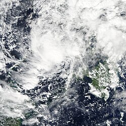
PSWS map Durning the passage of Tropical Storm Washi (Sendong)Tropical Storm Washi in the Sulu Sea on December 17
Across the Cagayan de Oro river basin, a localized heavy rain event occurred during Tropical Storm Washi's passage.[3] Onshore flow from Macajalar Bay, which the Cagayan de Oro river drains into, ran into the steep terrain of Mount Makaturing, Mount Kalatungan, and Mount Kitanglad, resulting in orographic enhancement of precipitation. A weather station in Capehan located along the Bubunawan river, a tributary of the Cagayan de Oro river, recorded 475mm (18.7in) over a 24‑hour span.[1] The rainfall event itself amounted to a 1-in-20 year event for much of Misamis Oriental.[13] In the span of 24hours, 180.9mm (7.12in) of rain fell at Lumbia which equates to more than 60percent of their average December precipitation.[3] Estimates from the Tropical Rainfall Measuring Mission jointly run by NASA and JAXA indicated that accumulations around the Cagayan de Oro river exceeded 400mm (16in).[14] Observations from Talakag captured the sheer intensity of rainfall associated with Washi, with hourly accumulations peaking at 60.6mm (2.39in). Similar amounts, though less anomalous in magnitude, fell farther east on Mindanao. Satellite estimates indicated accumulations of 200 to 250mm (7.9 to 9.8in) along coastal areas near where Washi made landfall.[14] A total of 180.4mm (7.10in) was observed in Hinatuan.[3]
Satellite estimated rainfall from Severe Tropical Storm Washi over the Philippines. The areas in red indicate where more than 400mm (16in) of rain may have fallen.
Starting in tributaries and later reaching the main Cagayan de Oro, Iponan, and Mandulog rivers, flash flooding manifested at a dramatic pace.[1] In some locations, flood waters rose by 3.3m (11ft) in less than an hour.[15] Alongside the effects from rainfall, high tide at Macajalar Bay further enhanced the flood event and allowed water to inundate areas that would have otherwise safe at low tide. The rivers crested at 7 to 9m (23 to 30ft), amounting to a 75-year flood event in some areas, with catastrophic results.[3][1] This was also far higher than the previous flood event following Tropical Depression Auring in January2009. Located outside the main "typhoon belt," residents in the affected areas suffered from a false sense of security with tropical cyclone related disasters. Flooding from the rivers struck at approximately 2:30a.m. local time, when most people were asleep and unable to hear warnings from PAGASA. Hardest hit were the cities of Cagayan de Oro and Iligan where tremendous loss of life occurred. Within Cagayan de Oro, the barangay of Balulang, Carmen and Macasandig was virtually wiped out. Between the two cities, 1,147people lost their lives while a further 1,993sustained injury.[1] Residents affected by these flood waters were forced to seek refuge on their roofs amidst 90km/h (55mph) winds. The mayor of Iligan regarded the floods as the worst in the city's history.[16]
Throughout the affected areas, nearly 40,000homes were damaged of which 11,463were destroyed. Nearly 700,000people were affected by the storm.[1] Total casualties attributed to the event are uncertain, with the National Disaster Risk Reduction and Management Council's final report in February2012 stating 1,268fatalities, 181people missing, and 6,071injuries.[3] A later report by the World Meteorological Organization in December of that year indicated 1,292deaths, 1,049missing, and 2,002injured.[1] The International Federation of Red Cross and Red Crescent Societies stated a total of 2,546 deaths in their final report on August21, 2013.[2][17][18][bettersourceneeded] Damage directly related to the storm amounted to ₱2.068billion (2012PhP, $48.4million USD). Over half of the damage was due to damaged roads and bridges.[3] Total socio-economic losses amounted to US$97.8million.[1]
Highest Public Storm Warning Signal
PSWS#
Luzon
Visayas
Mindanao
2
Palawan
Southern Leyte, Bohol, Southern portion of Cebu, Southern portion of Negros Oriental, Southern Portion of Negros Occidental, Siquijor
Surigao del Norte incl. Siargao Island, Surigao del Sur, Dinagat Province, Agusan del Norte, Agusan del Sur, Davao del Norte, Davao Oriental, Samal Island, Lanao del Norte, Lanao del Sur, Misamis Occidental, Misamis Oriental, Zamboanga del Norte, Zamboanga del Sur, North Cotabato, Compostela Valley, Camiguin, Bukidnon, Maguindanao, Camotes Islands
Eastern Samar, Western portion of Samar, Northern portion of Leyte, Rest of Cebu, Rest of Negros Oriental, Rest of Negros Occidental, Capiz, Antique, Aklan, Iloilo, Guimaras
Cagayan de Oro following the aftermath of Tropical Storm WashiFlooding from Tropical Storm WashiSendong Memorial Tombstone for the Victims at Gaston Park, Cagayan de Oro
A massive relief operation involving the evacuation of 100,000 people occurred on the morning of December17, 2011. Approximately 20,000 soldiers were mobilized to assist in recovery efforts and evacuations.[16] The Philippine Coast Guard was dispatched to search for missing people after villages were reported to have been swept out to sea. Sixty people were rescued off the coast of El Salvador, Misamis Oriental and another 120 in the waters near Opol township.[27] President Benigno Aquino III visited Cagayan de Oro and Iligan on December20, 2011, and declared a state of national calamity in the affected provinces.[28] The President also appealed to its citizens to help the victims in their way of celebrating Christmas in his Christmas Message.[29]
A leptospirosis outbreak in the immediate aftermath infected more than 400people and killed 22. Additional fatalities from suicide took place in evacuation centers, though exact numbers are unknown.[1]
In the three years following Washi, ₱2.57billion (US$58million) was allocated to build 30,438shelters, designed to withstand winds of 220km/h (140mph), in eight regions. Less than half of this total had been built by December2014, though construction in Cagayan de Oro and Iligan was largely complete.[30] The storm prompted a shift in settlement patterns in Cagayan de Oro, with residents moving away from the areas along the Cagayan River in favor of upland areas.[31]
International aid and assistance
The Australian government provided A$1million (US$1.01million) in financial aid.[32] The Danish government provided 300,000DKK (US$53,000) in emergency funds for relief items such as food, water, sanitation materials, mattresses and blankets.[33] The European Commission allocated €3million ($3.9million) to provide emergency relief to tens of thousands of people affected by the storm.[34] The French Government provided €50,000 (US$65,000) in emergency funds.[35] The Government of Indonesia provided $50,000 in financial aid and offered to send search and rescue teams and medical teams.[32] The Japanese government provided 25million yen (US$320,000) worth of relief goods, such as water tanks and generators, for victims of the storm.[35]
The Government of Malaysia provided $100,000 in financial assistance for relief and rehabilitation.[35] The Chinese government provided $1.1million in financial aid.[32] The Government of Singapore provided S$50,000 (US$39,000) in funds and S$27,800 (US$22,000) worth of relief goods.[32] The Government of South Korea provided $500,000 in financial aid.[32] Six members of the Swiss Humanitarian Aid Unit were sent to Mindanao to ensure access to clean drinking water.[36]The British Red Cross provided £140,000 (US$220,000) in funds to support relief efforts.[37]
On December21, the United Nations Emergency Relief Agency released $3million in funds to improve water and sanitation. On December22, the United Nations Department of Humanitarian Affairs announced a plan to raise $26.8million in aid for victims of Severe Tropical Storm Washi. United Nations Secretary-GeneralBan Ki-moon sympathized with the Philippine Government and stated "the [United Nations] would extend whatever help is needed by those who were affected by the disaster."[35] The United Nations High Commissioner for Refugees also pledged to send 42metric tons of aid to the country.[32] The United Nations Children's Fund also appealed for $4.2million to be sent to the Philippines.[38]
Due to its high death toll, PAGASA announced that the name, Sendong, would be retired from their tropical cyclone naming lists.[40] In February 2012, the ESCAP/WMO Typhoon Committee announced that Washi would also be retired from its naming lists and was replaced with the name Hato.[41]
↑ "Tropical Cyclone Formation Alert". Joint Typhoon Warning Center. United States Navy. December 13, 2011. Archived from the original on October 21, 2011. Retrieved December 23, 2011.
↑ "High Seas Forecast". Japan Meteorological Agency. December 13, 2011. Archived from the original on October 19, 2011. Retrieved December 23, 2011.
↑ "Tropical Depression 27W Advisory Number 001". Joint Typhoon Warning Center. United States Navy. December 13, 2011. Archived from the original on May 23, 2024. Retrieved December 23, 2011.
↑ "Tropical Storm 27W Advisory Number 005". Joint Typhoon Warning Center. United States Navy. December 14, 2011. Archived from the original on May 23, 2024. Retrieved December 23, 2011.
↑ "Tropical Depression Sendong Advisory One". Philippine Atmospheric, Geophysical and Astronomical Services Administration. December 15, 2011. Archived from the original on May 23, 2024. Retrieved December 24, 2011.
↑ "Tropical Depression 27W Advisory Number 008". Joint Typhoon Warning Center. United States Navy. December 15, 2011. Archived from the original on May 23, 2024. Retrieved December 24, 2011.
↑ Del Rosario, Eduardo D (August 9, 2011). Final Report on Typhoon "Yolanda" (Haiyan)(PDF) (Report). Philippine National Disaster Risk Reduction and Management Council. pp.77–148. Archived(PDF) from the original on November 5, 2020. Retrieved March 27, 2022.
This page is based on this Wikipedia article Text is available under the CC BY-SA 4.0 license; additional terms may apply. Images, videos and audio are available under their respective licenses.


