Typhoon Matsa

Last updated
Map key
  Tropical depression (≤38 mph, ≤62 km/h)
  Tropical storm (39–73 mph, 63–118 km/h)
  Category 1 (74–95 mph, 119–153 km/h)
  Category 2 (96–110 mph, 154–177 km/h)
  Category 3 (111–129 mph, 178–208 km/h)
  Category 4 (130–156 mph, 209–251 km/h)
  Category 5 (≥157 mph, ≥252 km/h)
  Unknown
Storm type
Disc Plain black.svg Tropical cyclone
Solid black.svg Subtropical cyclone
ArrowUp.svg Extratropical cyclone, remnant low, tropical disturbance, or monsoon depression

The origin of Typhoon Matsa is traced to the formation of an area of convection about 185 km (115 mi) east of Yap in late July. The convection gradually consolidated over a weak low-level circulation, and at 0300 UTC on July 30 the system was first mentioned in the Joint Typhoon Warning Center (JTWC) Significant Tropical Weather Outlook. Located within an area of moderate wind shear, the system continued to slowly organize, and by 1200 UTC on July 30 it was sufficiently organized for the Japan Meteorological Agency (JMA) to classify it as a weak tropical depression while located about 65 km (40 mi) east of Yap. Shortly thereafter, the JTWC followed suit by issuing a tropical cyclone formation alert. The depression tracked steadily westward, followed by a turn to the northwest on July 31 under the influence of a mid-level ridge to its east. It continued to organize, and at 1200 UTC on July 31 it intensified into Tropical Storm Matsa; the depression was unofficially classified a tropical storm six hours earlier by the JTWC. Additionally, the Philippine Atmospheric, Geophysical and Astronomical Services Administration (PAGASA) named the system Tropical Storm Gorio, due to its location within the administration's area of responsibility. [1] [2] [3]

Tropical Storm Matsa gradually intensified as it tracked steadily northwestward; by late on August 1 it strengthened into a severe tropical storm. Outflow and deep convection to the north remained limited, though the storm was able to intensity further to attain typhoon status on August 2 about 780 km (480 mi) south of Okinawa. Intensification slowed, and late on August 3 Matsa reached a peak intensity of 150 km/h (93 mph) while located 495 km (308 mi) east of the southern tip of Taiwan as reported by the JMA; the JTWC and the National Meteorological Center of China reported the typhoon as strengthening further to attain peak winds of 165 km/h (103 mph) on August 4. Shortly after passing over the Japanese island of Ishigaki, Matsa began to weaken steadily as it approached the coast of China, and made landfall as a minimal typhoon late on August 5 near Yuhuan in the southern region of Zhejiang Province. It crossed the Gulf of Yueqing and 40 minutes after its first landfall it struck Mainland China near Yueqing. It quickly weakened to a tropical storm, and within hours of moving ashore the JTWC issued its last advisory. Matsa turned to the north, weakening to a tropical depression on August 7 shortly before entering the Yellow Sea. The weakening depression continued northward, and became an extratropical cyclone on August 9 after hitting the Liaodong Peninsula. [1] [2] [3]

Preparations

Typhoon Matsa making landfall on August 6 Typhoon Matsa (Landfall).PNG
Typhoon Matsa making landfall on August 6

The Taiwan Central Weather Bureau warned for the potential for heavy amounts of rainfall across the island. This resulted in officials to close schools and offices in Taipei. Additionally, the typhoon caused the cancellation or delay of several flights in and out of Taipei, [4] though complete air service was restored by the day after Matsa's passage. [5] The Taiwan Stock Exchange closed due to the threat of the typhoon. [6]

Prior to the arrival of the typhoon, officials in China ordered the evacuation of about 2.3 million people, mostly in Zhejiang. The typhoon also resulted in the cancellation or delay of thousands of flights, [1] with the two main airports in Shanghai closed for 30 hours. [7] Officials near Matsa's projected landfall were advised to lower the levels in reservoirs to mitigate the threat of flooding. [8] In Zhejiang, officials set up shelters for about 35,000 boats to prevent marine damage. [9] Due to the potential for rough seas, officials closed the port at Ningbo and Shanghai and also canceled some ferry service. [10] Matsa was predicted to be first typhoon to affect Beijing in 11 years by dropping heavy amounts of rainfall. [11] Local officials advised water operators to lower water levels to prevent flooding. [12] Up to 100 mm (3.9 in) of rainfall was forecast for the city, and officials prepared to evacuate 40,000 residents in the outskirts of the city. [13]

Impact

Taiwan

While passing to the north of Taiwan, Matsa produced strong winds reaching 144 km/h (89 mph), with gusts of up to 188 km/h (117 mph). [5] The storm dropped heavy rainfall across the island, with precipitation totals reaching up to 1,270 mm (50 in) in a 30‑hour period; one station located in Taitung County recorded 843 mm (33.2 in) in one day, which was the highest daily rainfall total in association with the storm. The rainfall led to flooding and mudslides throughout the island. [1] In response to the flooding, residents placed sandbags around houses and office buildings to prevent flood damage. [4] The mudslides blocked roads across the mountainous region, leaving hundreds stranded, and in combination with flooding the mudslides washed away several bridges and damaged some roadways. Strong winds left 56,211 houses without power, most of which were quickly repaired. Typhoon Matsa caused moderate crop damage across the island, which was still recovering from the damage caused by Typhoon Haitang a month before. [5] More than 80,000 homes were left without water due to the passage of the typhoon. [5] Subsequent flooding left more than 630,000 homes without water or receiving water at infrequent intervals. [14] About 368 hectares (910 acres) of crop fields were destroyed, [15] and crop damage from Matsa totaled NT$47 million (2005 TWD, $1.5 million 2005 USD). [1] According to the Taiwan Council of Agriculture, the banana and pear crops were the worst affected. [15]

China

Typhoon Matsa (Gorio)
Matsa 2005-08-04 1400Z.jpg
Typhoon Matsa at peak intensity on August 4
Deaths and damage by province
RegionDeathsDamage
(2005 CNY)
Damage
(2005 USD)
Zhejiang 58.9 billion$1.1 billion
Shanghai 71.3 billion$165 million
Jiangsu 83.4 billion$420 million
Anhui 2660 million$81 million
Shandong 02.9 billion$358 million
Liaoning 3600 million$74 million
Hebei 0170 million$21 million
Total2518 billion$2.23 billion

Upon making landfall in China, several coastal locations reported winds in excess of 120 km/h (75 mph), with wind gusts peaking at 175 km/h (109 mph). Further inland, winds reached 147 km/h (91 mph) at Shanghai, the highest wind gust on record in the city. The storm produced heavy amounts of rainfall, reaching a maximum of 701 mm (27.6 in) at a station in Yongjia County. Extreme amounts of precipitation fell in short durations, including 91 mm (3.6 in) in just 1 hour and 200 mm (7.9 in) in 3 hours at Dinghai District. [1] Just days after a previous heavy rainfall event, [16] the rainfall from Matsa caused record-breaking river flooding along eight Chinese rivers, including a station at a floodgate on Suzhou Creek which peaked at 4.55 m (14.9 ft). [1]

Matsa on August 5 TRCmatsa217 G9.jpg
Matsa on August 5

In Zhejiang, where Matsa made landfall, high storm tides occurred along the coastline. In some areas, water levels rose quickly, [8] with some coastal homes experiencing flooding from the tide. Rough seas off of Ningbo capsized a fishing boat, leaving its three occupants missing. [10] About two-thirds of the province reported more than 50 mm (2.0 in) of rainfall, [17] resulting in flooding in low-lying areas [8] as well as several mudslides, [10] one of which killed two people. [18] The combined effects of the winds and rains destroyed 21 reservoirs and more than 200 km (120 mi) of embankment, and damaged several water stations. [17] Matsa damaged 3,380 km2 (1,310 sq mi) of crops, [1] with around 224 km2 (86 sq mi) of cropland destroyed from the flooding. [10] About 13,000 houses were destroyed in the province. Throughout Zhejiang, Matsa caused $8.9 billion (2005  CNY, $1.1 billion 2005 USD) in damage and five direct fatalities. [1]

Heavy rainfall in Shanghai flooded 84 city streets; in some locations insufficient water drainage left homes and apartments flooded, [19] with a total of 20,000 houses reporting flooding. [7] The flooding also closed the city subway system for a few hours. [1] Strong winds downed 2,700 trees and 400 power lines in the city. [7] The typhoon damaged a construction site in the city, leaving three injured and one person killed. [20] Throughout the city an estimated 15,000 houses were destroyed. Additionally, four people were electrocuted as a result of the flooding. [12] In Shanghai alone, damage totaled $1.33 billion (2005  CNY, $164.5 million 2005 USD); seven people died in the city. [1]

Despite the anticipated effects, Beijing experienced only light rainfall. [13] Throughout China, over 31 million people were affected in over eight provinces. Typhoon Matsa left the agricultural industry severely impacted, with over 20,000 km2 (7,700 sq mi) damaged. [1] The combination of its winds and flooding damaged around 200,000 buildings, [21] including a total of 59,000 destroyed houses. Damage in the country totaled about $18 billion (2005  CNY, $2.23 billion 2005 USD). [1]

Okinawa and South Korea

Typhoon Matsa affected the southernmost Okinawa Prefecture, and produced peak wind gusts of 182 km/h (51 m/s; 113 mph) on Ishigaki. The storm dropped moderate to heavy rainfall across the region, peaking at 318 mm (12.5 in) on Miyako-jima. [1]

The remnants of Matsa also affected South Korea, with moderate amounts of rainfall reaching 229 mm (9.0 in) in Masan. [1]

Aftermath

Subsequent to the passage of the typhoon in Taiwan, large quantities of mud and impurities entered and polluted the Shihmen Reservoir in Taoyuan County (now Taoyuan City), [22] the county's primary source of water. [23] Severe cloudiness occurred in the water, and at one time the reservoir recorded 25,000 nephelometric turbidity units. [14] Such facilities are unable to operate with mud in the water, [24] and in response, the Taiwan Water Corporation established temporary water stations to alleviate the situation, [5] and the Pingting Water Treatment Plant worked to treat the problem. [14] Furthermore, officials drilled wells to accommodate the shortage. Water supply in the southern portion of Taoyuan County was restored by five days after the storm, [25] with supply restored to the northern portion of the county by ten days after the passage of the typhoon. [23] The same problem had occurred previously after Typhoon Mindulle in July 2004. [14] As a result of the crop damage, the Taiwan Council of Agriculture opened its reserve of frozen vegetables to prevent overharvesting of the existing crops. [5] Despite the measures, crop prices reached record levels, which led to groups calling out for the government to stabilize the price of foods. In reaction, a member of the Council of Agriculture remarked that "vegetable prices [were] expected to go back to normal gradually ... as supplies increase[d]." [26] The passage of the typhoon left hundreds of residents in Hsinchu County isolated from the outside world for four days. As a result, officials deployed helicopters with rescue supplies and returned with the injured. Aid from one internal organization totaled $NT300,000 (2005 TWD, $9,500 2005 USD). [27] Shortly after the effects of the typhoon ended on the island, work began to repair and rebuild the impacted bridges and roads. Electricians quickly began restoring power across northern Taiwan; by the day after the typhoon's passage, the number of houses without power decreased by 90%. [28]

In the People's Republic of China, members of the People's Liberation Army assisted in search and rescue operations. [18] Officials called for about 100,000 citizens in Shanghai for work in disaster control and distribution of relief aid, [29] with some providing relief supplies to flooded areas by inflatable rafts. [30] Within a month, Typhoons Talim and Khanun also affected the same area, further compounding the effects of Matsa. [31] During the 38th Session of the World Meteorological Organization in Hanoi, Vietnam, the name Matsa was retired; [32] during the next session, the name Pakhar was nominated as its replacement. [33] It was first used in the 2012 season.

See also

Related Research Articles

<span class="mw-page-title-main">2004 Pacific typhoon season</span> Typhoon season in the Western Pacific Ocean

The 2004 Pacific typhoon season was an extremely active season that featured the second-highest ACE ever recorded in a single season, second only to 1997, which featured 29 named storms, nineteen typhoons, and six super typhoons. It was an event in the annual cycle of tropical cyclone formation, in which tropical cyclones form in the western Pacific Ocean. The season ran throughout 2004, though most tropical cyclones typically develop between May and October. The season's first named storm and also the first typhoon, Sudal, developed on April 4, later was reached typhoon status two days later, and became the first super typhoon of the year three days later. The season's last named storm, Noru, dissipated on December 21.

<span class="mw-page-title-main">2003 Pacific typhoon season</span> Typhoon season in the Western Pacific Ocean

The 2003 Pacific typhoon season was a slightly below average yearlong period of tropical cyclogenesis exhibiting the development of 45 tropical depressions, of which 21 became named storms; of those, 14 became typhoons. Though every month with the exception of February and March featured tropical activity, most storms developed from May through October. During the season, tropical cyclones affected the Philippines, Japan, China, the Korean Peninsula, Indochina, and various islands in the western Pacific.

<span class="mw-page-title-main">2002 Pacific typhoon season</span> Typhoon season in the Western Pacific Ocean

The 2002 Pacific typhoon season was a slightly above average Pacific typhoon season, producing twenty-six named storms, fifteen becoming typhoons, and eight super typhoons. It had one of the highest ACE of any season worldwide, with over 400 units. It was an event in the annual cycle of tropical cyclone formation, in which tropical cyclones form in the western Pacific Ocean. The season ran throughout 2002, though most tropical cyclones typically develop between May and October. The season's first named storm, Tapah, developed on January 11, while the season's last named storm, Pongsona, dissipated on December 11. The season's first typhoon, Mitag, reached typhoon status on March 1, and became the first super typhoon of the year four days later.

<span class="mw-page-title-main">1990 Pacific typhoon season</span> Typhoon season in the Pacific Ocean

The 1990 Pacific typhoon season was another active season. It has no official bounds; it ran year-round in 1990, but most tropical cyclones tend to form in the northwestern Pacific Ocean between May and November. These dates conventionally delimit the period of each year when most tropical cyclones form in the northwestern Pacific Ocean.

<span class="mw-page-title-main">Typhoon Saomai</span> Pacific typhoon in 2006

Typhoon Saomai, known in the Philippines as Typhoon Juan, was considered the most powerful typhoon on record to strike the east coast of the People's Republic of China. It was the eighth tropical storm, fifth typhoon, and third super typhoon of the 2006 Pacific typhoon season recognized by the Joint Typhoon Warning Center. According to the Japan Meteorological Agency, Saomai was the seventh tropical storm and fifth typhoon of the season. The name "Saomai" was submitted by Vietnam, and is from the Vietnamese word for "morning star", a reference to the planet Venus.

<span class="mw-page-title-main">Tropical Storm Bilis</span> Pacific severe tropical storm in 2006

Severe Tropical Storm Bilis, known in the Philippines as Tropical Storm Florita, was a weak tropical cyclone in July 2006 that caused catastrophic damage to areas of the Philippines, Taiwan, and southeastern China. The word Bilis, submitted by the Philippines, means 'speed' or 'swiftness' in Tagalog.
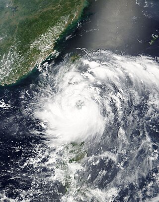
<span class="mw-page-title-main">Typhoon Fung-wong (2008)</span> Pacific typhoon in 2008

Typhoon Fung-wong, known in the Philippines as Typhoon Igme, was a deadly typhoon in the 2008 Pacific typhoon season which made landfall on Taiwan and China. Typhoon Fung-wong reached peak intensity of a Category 2 typhoon on the Saffir-Simpson Hurricane Scale by the Joint Typhoon Warning Center with peak winds of 95 knots (176 km/h). Damage was extensive in Taiwan, hitting little more than a week later than Typhoon Kalmaegi, but a specific cost is unknown, though later estimated at 541 million.

<span class="mw-page-title-main">Typhoon Jangmi (2008)</span> Pacific typhoon in 2008

Typhoon Jangmi, known in the Philippines as Typhoon Ofel, was the most intense tropical cyclone in the Northwest Pacific Ocean during the 2000s, tied with Nida in 2009, and the most intense tropical cyclone worldwide in 2008. Jangmi, which means rose in Korean, formed in a low pressure area south of Guam on September 22. After undergoing serious consolidating with convective banding, the low pressure area was upgraded to a Joint Typhoon Warning Center late the same data. Undergoing the same process, the storm developed into a tropical storm on September 24. Undergoing rapid deepening on September 26–27, the storm, now a Super Typhoon entered the Philippine Area of Responsibility, and was named Ofel. The next day, Jangmi made impact in Taiwan, thousands were evacuated, rainfall, up to 994mm were recorded, and thousands of acres of farmland were destroyed. Jangmi was significantly weakened as it interacted with Taiwan, as being downgraded to tropical storm status after leaving Taiwan on September 29. After undergoing an extratropical transition, Jangmi became a remnant low on October 1. After slowly moving eastward, until finally dissipating near Iwo Jima on October 5.

<span class="mw-page-title-main">Typhoon Wipha (2007)</span> Pacific typhoon in 2007

Typhoon Wipha, known in the Philippines as Typhoon Goring, was the strongest typhoon to threaten the Chinese coastline since Typhoon Saomai in August 2006. Forming out of a tropical disturbance on September 15, 2007, it quickly developed into a tropical storm, and intensified into a typhoon the following day with the appearance of an eye feature. After a period of rapid intensification, Wipha attained its peak intensity on September 18, with winds of 185 km/h (115 mph) and a barometric pressure of 925 mbar (hPa), according to the Japan Meteorological Agency. Later that day, the storm began to weaken as it interacted with the mountainous terrain of Taiwan before brushing the northern edge of the island. Wipha subsequently made landfall near Fuding along the Fujian–Zhejiang provincial border with winds estimated at 185 km/h (115 mph) by the JTWC. Shortly thereafter, the typhoon weakened as it moved inland, weakening to a tropical storm within 18 hours of moving over land.

<span class="mw-page-title-main">Typhoon Winnie</span> Pacific typhoon in 1997

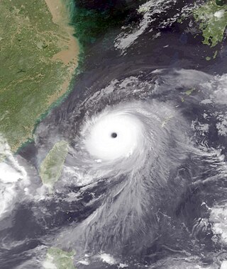
Typhoon Winnie, known in the Philippines as Typhoon Ibiang, was the most destructive tropical cyclone to impact the Chinese provinces of Zhejiang, Fujian, Jiangsu, and Shandong in 200 years. Originating from an area of low pressure over the Pacific Ocean on August 5, 1997, the system organized into a tropical depression. It headed northwestward, slowly strengthening into a tropical storm on August 9. Intensification became more rapid as conditions became more favorable, and Winnie reached typhoon strength on August 10. On August 12, 1997, Winnie became a Category 5-equivalent super typhoon, with peak 1-minute sustained winds of 160 miles per hour (260 km/h). Winnie then weakened and passed north of Taiwan, before making landfall in Eastern China at Category 1-equivalent typhoon strength on the August 18. Winnie continued northeast over land while weakening, bringing heavy rainfall before dissipating on August 23.

<span class="mw-page-title-main">Typhoon Rananim</span> Pacific typhoon in 2004

Typhoon Rananim, known in the Philippines as Typhoon Karen, was the strongest typhoon to make landfall on the Chinese province of Zhejiang since 1956. It formed on August 6, 2004, intensifying into a tropical storm on August 8. Rananim gradually intensified, initially moving northward before turning to the northwest and attaining typhoon status. After developing a small eye, the typhoon attained peak winds of 150 km/h (93 mph) as it passed between Taiwan and Okinawa. On August 12, Rananim moved ashore in China, and it dissipated three days later. The name Rananim means "hello" in the Chuukese language.

<span class="mw-page-title-main">Typhoon Alex (1987)</span> Pacific typhoon in 1987

Typhoon Alex, known in the Philippines as Typhoon Etang, affected the Taiwan, China, and South Korea during July 1987. Typhoon Alex developed from the monsoon trough that spawned a tropical disturbance late on July 21 southwest of Guam which organized into a tropical depression shortly thereafter. The system steadily became better organized, and the next day, a tropical depression had developed. Satellite intensity estimates gradually increased, and on July 23, the depression intensified into Tropical Storm Alex. After initially tracking west-northwest, Tropical Storm Alex started tracking northwest. An eye developed on July 24, and on the next day, Alex was classified as a typhoon, when Alex attained its peak intensity of 120 km/h (75 mph) and a minimum barometric pressure of 970 mbar (29 inHg). Alex weakened while tracking more northward, though interaction with Taiwan resulted in a more westward track starting on July 27. The storm struck near Shanghai as a tropical storm, and weakened over land, although it remained identifiable through August 2.

<span class="mw-page-title-main">Typhoon Fred</span> Pacific typhoon in 1994

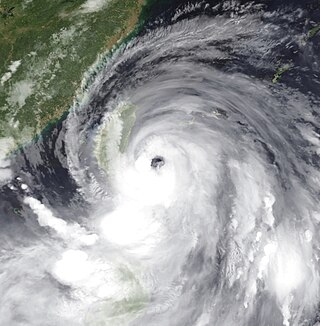
Typhoon Fred was a powerful tropical cyclone that caused extensive damage in southeastern China in mid-August 1994. Regarded as the worst typhoon to affect Zhejiang in 160 years, it originated as an area of disturbed weather over the open West Pacific on August 13. The system moved west-southwest and developed into a tropical depression on August 14. Early on August 15, it intensified into a tropical storm. Fred intensified at a steady rate over the course of several days while moving toward the west. The storm intensified into a typhoon on August 16 and into a super typhoon three days later. Late on August 19, the Japan Meteorological Agency (JMA), the principal organization in the West Pacific, estimated 10-minute sustained winds of 185 km/h (115 mph). The Joint Typhoon Warning Center (JTWC), meanwhile, assessed 1-minute sustained winds of 240 km/h (150 mph). After peaking in intensity, Fred veered to the north of Taiwan and struck the China mainland near Wenzhou early on August 21. The system degraded once inland and dissipated near Wuhan on August 22.

<span class="mw-page-title-main">Typhoon Sarah (1989)</span> Pacific typhoon in 1989

Typhoon Sarah, known in the Philippines as Typhoon Openg, was a powerful typhoon that caused extensive damage along an erratic path across the Western Pacific in September 1989. Originating from a disturbance within a monsoon trough in early September, Sarah was first classified as a tropical depression near the Mariana Islands on September 5. Moving quickly westward, the depression soon strengthened into Tropical Storm Sarah. On September 8, the storm abruptly turned southward and temporarily attained typhoon status. Following a series of interactions with secondary areas of low pressure, the storm turned northward the following day. By September 11, Sarah entered a region favoring development and underwent a period of explosive intensification. At the end of this phase, the storm attained its peak intensity as a Category 4–equivalent typhoon on the Saffir–Simpson Hurricane Scale. The typhoon subsequently weakened rapidly and made two landfalls in Taiwan by September 12. After moving over the Taiwan Strait, Sarah made its final landfall in Eastern China on September 13 before dissipating the following day.

<span class="mw-page-title-main">Typhoon Sinlaku (2002)</span> Pacific typhoon in 2002

Typhoon Sinlaku was a damaging typhoon that affected Okinawa, Taiwan, and eastern China in September 2002. The 16th named storm of the 2002 Pacific typhoon season, Sinlaku formed on August 27 northeast of the Northern Marianas Islands. After initially moving to the north, it began a generally westward motion that it maintained for the rest of its duration. Sinlaku strengthened into a typhoon and attained its peak winds on August 31. Over the next few days, it fluctuated slightly in intensity while moving over or near the Ryukyu Islands. On September 4, the typhoon's eye crossed over Okinawa. It dropped heavy rainfall and produced strong winds that left over 100,000 people without power. Damage on the island was estimated at $14.3 million.

<span class="mw-page-title-main">Typhoon Rammasun (2002)</span> Pacific typhoon in 2002

Typhoon Rammasun, known in the Philippines as Typhoon Florita, was the first of four typhoons to contribute to heavy rainfall and deadly flooding in the Philippines in July 2002. The fifth tropical cyclone of the 2002 Pacific typhoon season, Rammasun developed around the same time as Typhoon Chataan, only further to the west. The storm tracked northwestward toward Taiwan, and on July 2 it attained its peak intensity with winds of 155 km/h (96 mph). Rammasun turned northward, passing east of Taiwan and China. In Taiwan, the outer rainbands dropped rainfall that alleviated drought conditions. In China, the rainfall occurred after previously wet conditions, resulting in additional flooding, although damage was less than expected; there was about $85 million in crop and fishery damage in one province.

<span class="mw-page-title-main">Typhoon Dujuan (2003)</span> Pacific typhoon in 2003

Typhoon Dujuan, known in the Philippines as Typhoon Onyok, was the strongest tropical cyclone to strike the Pearl River delta since Typhoon Hope in 1979. The 13th storm and 7th typhoon of the 2003 Pacific typhoon season, Dujuan developed on August 27 to the east of Taiwan. It initially moved to the northwest, slowly intensifying into a tropical storm while drawing moisture and rainfall over the Philippines. On the island of Luzon, one person was killed and areas were flooded. Dujuan quickly intensified after turning and moving quicker to the west-northwest, developing an eye. It reached peak winds of 150 km/h (93 mph) on September 1, and shortly thereafter passed just south of Taiwan. There, Dujuan left 590,000 people without power, killed three, and caused NT$200 million in crop damage. While moving through the South China Sea, the typhoon developed concentric eyewalls. Dujuan weakened to severe tropical storm status before making landfall on September 2 in southern China, just east of Hong Kong near Shenzhen, Guangdong. The storm dissipated the next day after causing 40 deaths and ¥2.3 billion in damage. Most of the deaths were in Shenzhen where the storm moved ashore, and the city experienced a near-total power outage.

<span class="mw-page-title-main">Tropical Storm Morakot (2003)</span> Pacific tropical storm in 2003

Tropical Storm Morakot, known in the Philippines as Tropical Storm Juaning, brought significant rainfall to Taiwan before alleviating drought conditions in mainland China in August 2003. The tenth named storm in the western Pacific that year, Morakot spawned from an area of disturbed weather in the Philippine Sea on July 31. Tracking northwest, favorable conditions allowed for the intensification of the system to tropical storm strength on August 2. Morakot reached peak intensity later that day with winds of 85 km/h (50 mph) and a minimum barometric pressure of 992 mbar. This intensity was held for several hours until less conducive atmospheric conditions slightly weakened the system; this was followed by Morakot making landfall on southern Taiwan on August 3. Subsequently, the storm weakened and moved into the Taiwan Strait before making its final landfall near Quanzhou, China the next day. The storm quickly weakened over the Chinese mainland, and dissipated entirely several hours after landfall.

<span class="mw-page-title-main">Typhoon Fitow</span> Pacific typhoon in 2013

Typhoon Fitow, known in the Philippines as Typhoon Quedan, was the strongest typhoon to make landfall in Mainland China during October since 1949. The 21st named storm of the 2013 Pacific typhoon season, Fitow developed on September 29 to the east of the Philippines. It initially tracked north-northwestward, gradually intensifying into a tropical storm and later to typhoon status, or with winds of at least 120 km/h (75 mph). Fitow later turned more to the west-northwest due to an intensifying ridge to the east, bringing the typhoon over the Ryukyu Islands with peak winds of 140 km/h (87 mph) on October 5. The next day, the typhoon struck China at Fuding in Fujian province. Fitow quickly weakened over land, dissipating on October 7.

<span class="mw-page-title-main">Typhoon Abe (1990)</span> Pacific typhoon in 1990

Typhoon Abe, known as Typhoon Iliang in the Philippines, was the fourteenth named storm of 1990 Pacific typhoon season. Forming on August 23 from a tropical disturbance, the depression which would eventually develop into Typhoon Abe initially tracked in a steady west-northwestward direction. As a result of an intense monsoon surge, Abe's trajectory briefly changed to an eastward then northward path before returning to its original track. Abe only intensified by a small amount between 00:00 UTC August 24 and 06:00 UTC August 27 due to the disruptive effects of the surge, and on August 30, Abe peaked in intensity as a Category 2-equivalent typhoon on the Saffir–Simpson hurricane wind scale. After peaking in intensity, Abe crossed the Ryukyu Islands and the East China Sea, making landfall in China where it affected the provinces of Zhejiang and Jiangsu before entering the Yellow Sea, crossing South Korea, and finally transitioning into an extratropical cyclone.
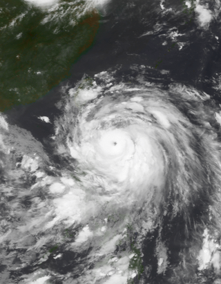
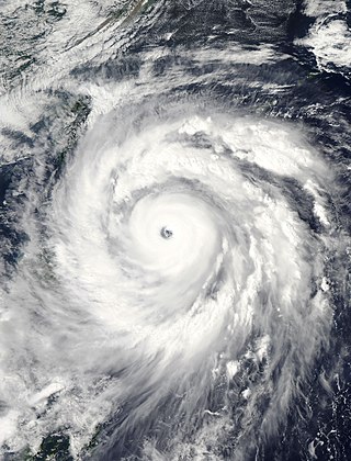
References

  1. 1 2 3 4 5 6 7 8 9 10 11 12 13 14 15 16 Gary Padgett (2005). "Monthly Global Tropical Cyclone Summary August 2005" . Retrieved 2007-04-15.
  2. 1 2 Joint Typhoon Warning Center (2007). "Typhoon (TY) 09W (Matsa) Report". Archived from the original on June 7, 2011. Retrieved 2007-04-15.
  3. 1 2 Japan Meteorological Agency (2005). "2005 Western Pacific Best Track". Archived from the original on December 10, 2006. Retrieved 2007-04-15.
  4. 1 2 Gary Carpenter (2005). "Catastrophe Information for Typhoon Matsa: Status Report 1" (PDF). Retrieved 2007-04-15.[ dead link ]
  5. 1 2 3 4 5 6 Jessie Ho (2005-08-06). "More rain as Matsa heads for China". Taipei Times. Retrieved 2007-04-18.
  6. Agence France-Presse (2005-08-07). "Asian stock markets enter mid-summer doldrums" . Retrieved 2007-04-21.
  7. 1 2 3 Guy Carpenter (2005). "Catastrophe Information for Typhoon Matsa: Status Report 2" (PDF). Retrieved 2007-04-16.[ dead link ]
  8. 1 2 3 Xinhua News Agency (2005-08-06). "Typhoon Matsa Batters East China" . Retrieved 2007-04-21.
  9. Xinhua News Agency (2005-08-06). "Zhejiang evacuates 510,000 as typhoon Matsa approaches". Archived from the original on October 8, 2012. Retrieved 2007-04-21.
  10. 1 2 3 4 Bill Savadove; Lillian Yang (2005-08-06). "Shanghai braces for powerful typhoon". South China Morning Post.
  11. Danwei- Chinese media, advertising; urban life (2005). "Beijing Media Top Stories: Typhoon Matsa, Six-party talks and soccer" . Retrieved 2007-04-18.
  12. 1 2 Jane Cai; Vivian Wu (2005-08-09). "Beijing escapes downpour as killer storm loses power". South China Morning Post.
  13. 1 2 Irene Wang (2005-08-11). "Chief rides storm over typhoon prediction". South China Morning Daily.
  14. 1 2 3 4 Lee Ken-cheng (2005-08-13). "Water woes demand creative fixes". Taipei Times. Retrieved 2007-04-18.
  15. 1 2 Sofia Wu (2005-08-06). "Agricultural Losses from Typhoon Matsa Estimated at NT$4.7 Million". Taiwan Central News Agency.
  16. International Federation of Red Cross and Red Crescent Societies (2005-08-05). "China: Floods Information Bulletin No. 7". Office for the Coordination of Humanitarian Affairs . Retrieved 2007-04-21.
  17. 1 2 Xinhua News Agency (2005-08-07). "Typhoon Matsa kills 2, causes huge damages in Zhejiang".
  18. 1 2 Deutsche Presse-Agentur (2005-08-07). "Typhoon results in four deaths, millions in damage in China".
  19. Xinhua News Agency (2005-08-07). "Shanghai lifts typhoon warning as Matsa moves northwest".
  20. Quentin Sommerville (2005-08-06). "Typhoon drives million from homes". BBC. Retrieved 2007-04-18.
  21. Xinhua News Agency (2005-08-09). "Matsa causes huge economic losses in E. China province".
  22. Chiu Yu-Tzu AND Jimmy Chuang (2005-09-05). "Typhoon Talim hits with force". Taipei Times. Retrieved 2007-04-18.
  23. 1 2 Taipei News (2005-08-20). "Hsieh wants to fill Yin's position within a week" . Retrieved 2007-04-18.
  24. Lee Hong-yuan (2005-08-12). "The price of water is just too low". Taipei Times. Retrieved 2007-04-18.
  25. Elizabeth Hsu (2005-08-12). "Government to Drill Wells to Ease Northern Taoyuan Water Shortage". Central News Agency.
  26. Central News Agency (2005-08-09). "Opposition Parties Urge Government to Stabilize Food Prices".
  27. Taipei Times (2005-08-10). "Airlifts of basic necessities go on for Hsinchu villages" . Retrieved 2007-04-20.
  28. "Taiwan Sizes Up Damage After Typhoon Matsa". Associated Press. 2005-08-06.
  29. Press Trust of India (2005-08-07). "Typhoon Matsa ravages eastern China".
  30. Agence France Presse (2005-08-07). "China mops up after typhoon ravages coastal areas, leaving four dead".
  31. Xinhua News Agency (2005-09-11). "Chinese vice premier condoles with local people of typhoon hit areas".
  32. ESCAP/WMO Typhoon Committee (2006). "Draft Report of the 38th Session". Archived from the original on 2014-03-16. Retrieved 2007-04-22.
  33. World Meteorological Organization (2007). "Report on the 39th Session" (in Chinese). Government of China. Archived from the original on 2007-09-28. Retrieved 2007-04-22.