 Parma at peak intensity on October 1 | |
| Meteorological history | |
|---|---|
| Formed | September 27,2009 |
| Dissipated | October 14,2009 |
| Very strong typhoon | |
| 10-minute sustained (JMA) | |
| Highest winds | 185 km/h (115 mph) |
| Lowest pressure | 930 hPa (mbar);27.46 inHg |
| Category 4-equivalent super typhoon | |
| 1-minute sustained (SSHWS/JTWC) | |
| Highest winds | 250 km/h (155 mph) |
| Lowest pressure | 922 hPa (mbar);27.23 inHg |
| Overall effects | |
| Fatalities | 500 total |
| Damage | $617 million (2009 USD) |
| Areas affected |
|
| IBTrACS | |
Part of the 2009 Pacific typhoon season | |
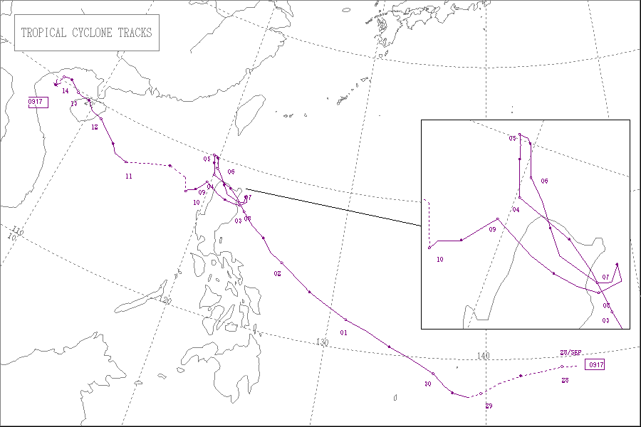
Typhoon Parma,locally named Pepeng, [nb 1] was a strong,deadly and erratic tropical cyclone that became the second-wettest typhoon to affect the Philippines,and the second typhoon to affect the country within the span of a week during September 2009.
Contents
- Meteorological history
- Preparations
- Caroline Islands
- Philippines
- Taiwan
- Impact
- Caroline Islands 2
- Philippines 2
- Taiwan 2
- China
- Vietnam
- Retirement
- See also
- Notes
- References
- External links
Typhoon Parma was named by PAGASA as Pepeng when it entered the Philippine Area of Responsibility days after Typhoon Ketsana wreaked havoc on the country;Parma spared the capital and instead lashed the northern part of Luzon island. Parma added to the damage brought about by the earlier Typhoon Ketsana,affecting thousands of families on the north,especially in the province of Pangasinan where the San Roque Dam inadvertently released water to prevent its breach. However,in the first week of October,Parma interacted with the incoming Typhoon Melor on the Pacific (via a Fujiwhara interaction),rendering it stationary as it made landfall on Southern Taiwan. Days later,the greatly weakened Parma retreated back to Luzon,making further landfalls on Ilocos Norte and Cagayan. The now Severe Tropical Storm Parma then began to wane its strength,as it crossed Luzon island for the second time. It then emerged on the South China Sea as a tropical depression,before restrengthening into a tropical storm and striking Hainan and Vietnam before finally dissipating in October 14.
Parma's bizarre,long-lived,and erratic track over northern Luzon led to near-record levels of rainfall, [1] causing devastating flooding that led to Parma becoming one of the deadliest typhoons to hit the Philippines in a decade. Due to the high death toll and damages,both the JMA and PAGASA retired Parma and Pepeng from their respective naming lists.


