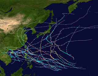
The 1973 Pacific typhoon season, in comparison to the two years preceding it, was a below average season, with only 21 named storms and 12 typhoons forming. However, it featured Typhoon Nora, which ties Typhoon June of 1975 for the second strongest typhoon on record. It has no official bounds; it ran year-round in 1973, but most tropical cyclones tend to form in the northwestern Pacific Ocean between June and December. These dates conventionally delimit the period of each year when most tropical cyclones form in the northwestern Pacific Ocean.

The 1953 Pacific typhoon season has no official bounds; it ran year-round in 1953, but most tropical cyclones tend to form in the northwestern Pacific Ocean between June and December. These dates conventionally delimit the period of each year when most tropical cyclones form in the northwestern Pacific Ocean.

Typhoon Xangsane, known in the Philippines as Typhoon Reming, was a typhoon that made landfall in the Philippines and Taiwan. The 30th named storm and 12th typhoon of the 2000 Pacific typhoon season. Xangsane made landfall in southern Luzon in the Philippines, on October 27. The storm then turned north, heading northeastward over the South China Sea. On October 29, Xangsane reached its peak intensity, with 10-minute sustained winds of 140 km/h (87 mph), 1-minute sustained winds of 165 km/h (103 mph) and a minimum barometric pressure of 960 hPa (28 inHg). The storm paralleled the eastern coast of Taiwan, the next day. After leaving the vicinity of Taiwan, Xangsane started to weaken as it continued to move northeastward over the East China Sea and subsequently transitioned to an extratropical cyclone, midway between the eastern coast of China and the northern Okinawa Islands, on November 1. Xangsane was responsible for 187 casualties, including 83 possibly indirectly from the crash of Singapore Airlines Flight 006 on October 31, 2000.

Typhoon Bart, known in the Philippines as Typhoon Oniang, was a powerful and destructive typhoon that occurred during the 1999 Pacific typhoon season. It was the only super typhoon of that year. Bart reached "super typhoon" status on September 22, when it grew to comprise winds containing a force of 260 km/h (160 mph).

Typhoon Damrey, known in the Philippines as Typhoon Labuyo, was a typhoon that hit Vietnam and China in September 2005. The typhoon was the most powerful storm to affect Hainan in over 30 years, killing more than 113 people.
Typhoon Marie, as known as the Tōya Maru Typhoon in Japan, was a typhoon that hit Japan in September 1954. Marie did a great deal of damage to Hokkaido, and the Tōya Maru train ferry sank due to the high waves and windstorm caused by Marie. Because of it, JMA in Japan named the storm Tōya Maru Typhoon.

Typhoon Kai-tak, also known in the Philippines as Typhoon Edeng, was a typhoon that formed in July 2000 and brought severe impacts to the Philippines and Taiwan.

Typhoon Tess, known in Japan as Typhoon No. 13, was a typhoon that caused great damage to Japan in September 1953 while Japan was still in the middle of post-war recovery. A depression formed in the Caroline Islands, moving northwest over the following days, the storm then rapidly enlarged, becoming a category-5 equivalent typhoon. Tess then crossed the Shima peninsula and made landfall over Japan. The storm then weakened and dissipated over September 29.

Typhoon Della, known in Japan as the 3rd Miyakojima Typhoon and in the Philippines as Typhoon Maring, was a typhoon that struck Miyakojima of Ryukyu Islands and Kyūshū Island in September 1968.

Typhoon Vicki, known in the Philippines as Typhoon Gading, was a typhoon that was notable for having a strange eastward-northeastward track through the Philippines and Japan. The eleventh tropical depression, seventh named tropical storm and fourth typhoon of the inactive 1998 Pacific typhoon season, Vicki originated from an area of disturbed weather in the South China Sea.

Typhoon Georgia was one of the more impactful typhoons that struck Japan, as well as one of the few observed tropical cyclones that made direct landfall in Russia as a tropical storm. A low pressure system formed in the vicinity of Guam on August 10 which formed Tropical Depression Fran, and a new low-level center formed from a fracture of a trough that split newly formed tropical depression in the midnight of August 12. The newly formed low level center was classified as a tropical storm and was named Georgia hours later by the Joint Typhoon Warning Center. The new tropical storm was tracked by Japan Meteorological Agency shortly afterwards and Georgia rapidly intensified into a typhoon. On the next day, Georgia further intensified after passing Chichi Jima and reached peak sustained winds of 110 knots (57 m/s) while quickly accelerating in the north-northwest direction before striking Chūbu region in Japan on evening of the same day as a weakening typhoon. After emerging on the Sea of Japan as a tropical storm on August 14, Georgia made landfall in Soviet Union as a tropical storm at the afternoon of the same day, before transforming into an extratropical storm quickly after landfall. Remnants of Georgia was last noted on Heilongjiang, China on August 16.

Typhoon Songda, known in the Philippines as Super Typhoon Chedeng, was the strongest tropical cyclone worldwide in 2011. It caused moderate damage in the Philippines when it paralleled the country to the east as a Category 5–equivalent super typhoon; it later affected Taiwan and Japan as a weakening system. The fourth tropical depression, second named storm and the first super typhoon of the 2011 Pacific typhoon season, Songda formed from a non-tropical low that was embedded from the Intertropical Convergence Zone on May 17. An area of low-pressure subsequently formed and became organized for the JTWC to issue a TCFA on the system and the JMA to issue advisories, before both agencies declared it a tropical storm, earning the name Songda. Under favorable conditions, Songda slowly intensified as it entered the Philippine Area of Responsibility, with the PAGASA naming it Chedeng on May 23. On the next day, the three agencies declared the system a typhoon before rapidly intensifying to a super typhoon over the Philippine Sea. As it entered an unfavorable environment for further strengthening, Songda slowly weakened as it passed near Taiwan, before becoming extratropical near Japan. The remnants of the system slowly moved to the northeast, before absorbing to another extratropical cyclone to the south of Alaska.

Typhoon Talim, known in the Philippines as Typhoon Lannie, was an intense and destructive tropical cyclone that affected parts of East Asia, especially Japan, during September 2017. The eighteenth named storm and the sixth typhoon of the 2017 Pacific typhoon season, Talim's origins can be traced back to an area of low-pressure that the Joint Typhoon Warning Center first monitored on September 6. The disturbance was upgraded to a tropical depression by the Japan Meteorological Agency only two days later, and it became a tropical storm on September 9, earning the name Talim. Talim grew stronger over the next few days, eventually becoming a typhoon the next day. Within a favorable environment, the typhoon rapidly intensified after passing through the Ryukyu Islands. However, as it moved eastward, Talim started to weaken due to wind shear, and on September 16, it was downgraded to a tropical storm. The storm passed over Japan, near Kyushu the next day, before becoming extratropical on September 18. The extratropical remnants were last noted by the JMA four days later, before dissipating fully on September 22.

Typhoon Jane was a catastrophic and deadly tropical cyclone that left significant effects to Japan during the 1950 Pacific typhoon season. It caused over 398 reported deaths and 141 to be missing, mainly due to the landslides and flooding. It also destroyed some battle and cargo ships. The sixth reported typhoon of the season, Jane was first mentioned in weather maps as a tropical depression to the east of the Philippines. It quickly strengthened to a tropical storm as it moved to the northwest. It then curved to the northeast, reaching its peak intensity of 185 km/h before weakening and striking Minami in Tokushima Prefecture on September 3 as a Category 2 typhoon. It quickly weakened, passing through the Awaji Island and Kobe before becoming extratropical in the Sea of Japan on the same day. The extratropical remnants of the system persisted until it was no longer tracked on September 7.

Typhoon Dinah was a tropical cyclone that brought heavy damages to Japan, while leaving 65 fatalities and 70 to be missing, all in that country alone. It is also one of the disasters that happened in the country during the Showa 27 era. The second typhoon of the 1952 Pacific typhoon season, Dinah was first mentioned in weather maps as a tropical depression to the east of Visayas. It gradually organized, becoming a tropical storm on June 21 as it skirted the northeastern Philippines, with the Fleet Weather Center naming it Dinah. It strengthened further to a minimal typhoon as it moved through the Nansei Islands on June 22, before reaching its peak intensity of 140 km/h, as estimated by the Fleet Center. It then weakened shortly, before passing near Shikoku on the next day, then making landfall through the southern part of the Kii Peninsula before gradually weakened further and started to undergo extratropical transition as it moved out of the country on June 24. It then became fully extratropical on the next day.

Severe Tropical Storm Maliksi, known in the Philippines as Severe Tropical Storm Domeng, was a tropical cyclone in June 2018 that brought rainfall to the Philippines and Japan. It caused 2 deaths and prompted the PAGASA to declare the beginning of the rainy season in the Philippines. The fifth named storm and 4th tropical cyclone in the Philippine Area of Responsibility (PAR), it was first noted as an area of convection in the South of Palau on May 31.

Typhoon Louise, known in Japan as the Akune Typhoon, was a deadly and destructive tropical cyclone that hit Japan in October 1945, soon after the cessation of World War II. It caused at least 377 deaths and another 74 missing persons, while leaving a wide swath of damage across the country.

Typhoon Ione was a catastrophic and deadly tropical cyclone that left over 512 confirmed deaths and another 326 to be missing as it affected Japan, with the majority of the fatalities coming from the city of Ichinoseki in Iwate Prefecture. It also left a significant trail of damage on the country, just after Typhoon Kathleen devastated the area. The fourteenth named storm and the ninth typhoon of the 1948 Pacific typhoon season, Ione was first seen in weather maps as a tropical storm near the Mariana Islands on September 11. It moved to the northwest, passing through the island country, before strengthening to a typhoon on September 13. It rapidly organized to a Category 4 typhoon and reached its peak intensity on the next day before slowly weakening as it started to approach the Japanese archipelago, while curving to the northeast. It then made landfall on September 16 between the present cities of Tateyama and Kisarazu in Chiba Prefecture as a minimal typhoon. It then passed through the southern coast of Hokkaido, before gradually degraded to a tropical storm as it emerged in the Pacific Ocean on the next day. It then became extratropical, shortly after.

Typhoon Manny, known in the Philippines as Typhoon Naning, was a long-lived and deadly tropical cyclone that struck the Philippines during the 1993 Pacific typhoon season. It was the second typhoon to hit the Visayas, in the central Philippines, that year, following Kyle. The twenty-ninth named storm and fifteenth typhoon of the season, the system formed from a near-equatorial trough that also spawned Lola during the month in the east Caroline Islands on December 3. Moving northwestwards, it strengthened to a tropical storm on the next day before intensifying further to a severe tropical storm that night. The system attained typhoon status on December 8, while making an anticyclonic loop, nearly the same as Pamela, 11 years later. It then rapidly intensified while moving to the southwest, with the typhoon reaching its peak of 220 km/h (135 mph) and an unusually high barometric pressure of 960 mbar before crossing the central Philippines on December 10 and 11. It soon moved through the South China Sea as a tropical storm before weakening to a tropical depression as it encountered high wind shear. However, it restrengthened back to a tropical storm as it moved back again to a favorable environment before passing to the south of Vietnam as the system weakened back below gale-force winds. It then dissipated on December 16 as it passed through Thailand.

Typhoon Rex, known in the Philippines as Typhoon Deling, was the 4th named storm in 1998 Pacific typhoon season, and it approached Japan in late August. Rex did not made landfall in Japan, but 22 people were killed in heavy rains in some parts of Japan due to the weather front and Rex.


