Typhoon Hagupit (2014)

Last updated

Map key
  Tropical depression (≤38 mph, ≤62 km/h)
  Tropical storm (39–73 mph, 63–118 km/h)
  Category 1 (74–95 mph, 119–153 km/h)
  Category 2 (96–110 mph, 154–177 km/h)
  Category 3 (111–129 mph, 178–208 km/h)
  Category 4 (130–156 mph, 209–251 km/h)
  Category 5 (≥157 mph, ≥252 km/h)
  Unknown
Storm type
Disc Plain black.svg Tropical cyclone
Solid black.svg Subtropical cyclone
ArrowUp.svg Extratropical cyclone, remnant low, tropical disturbance, or monsoon depression

A tropical disturbance formed about 130 km (81 mi) north of the equator and about 530 km (330 mi) south-southwest of Kosrae in the afternoon of November 29, resulting in the Joint Typhoon Warning Center (JTWC) issuing a Tropical Cyclone Formation Alert on the next day for consolidating under favorable upper-level conditions. [12] [13] Early on December 1, the Japan Meteorological Agency (JMA) upgraded it to a tropical depression, and so did the JTWC designating it as 22W. [14] [15] Only six hours later, the JMA upgraded the system to a tropical storm and named it Hagupit, as well as the JTWC, owing to a consolidating low-level circulation center (LLCC) with tightly curved banding wrapping into the system. [4] [16] However, the RSMC best track data indicated that the system had been already a tropical depression since November 30 and a tropical storm early on December 1. [17] With low vertical wind shear and excellent radial outflow, Hagupit consolidated further on December 2 and was upgraded to a severe tropical storm by the JMA and a typhoon by the JTWC at noon. [5] [18] Late on the same day, the JMA upgraded it to a typhoon when it began to track west-northwestward along the southern periphery of the subtropical ridge. [19]

A swath of GPM/GMI precipitation rates over Typhoon Hagupit

Remaining in a favorable environment, Hagupit underwent rapid deepening in the afternoon on December 3 and as a result, the JTWC upgraded it to a super typhoon due to the system depicting a significant eye. [20]

The PAGASA named the typhoon Ruby as it entered the Philippine Area of Responsibility early on December 4. [21] Simultaneously, Hagupit presented the very tightly curved and deep convective banding with a clear 35 km (22 mi) eye, which 1-minute maximum sustained winds reached 285 km/h (177 mph), equivalent to Category 5 of the Saffir–Simpson hurricane wind scale (SSHWS). [22] The JTWC also forecast that Hagupit would become as strong as Typhoon Haiyan, but it failed to intensify further. [23] The JMA analyzed that Hagupit had reached peak intensity at 06:00 UTC, with the 10-minute maximum sustained winds at 215 km/h (134 mph) and the central pressure at 905 hPa (26.72 inHg). [6] However, the system then started an eyewall replacement cycle and due to moderate easterly vertical wind shear, became less symmetric, with the bulk of the deep convection displaced over the western semi-circle. [24]

Typhoon Hagupit approaching the Philippines on December 6 Hagupit 2014-12-06 0500Z.jpg
Typhoon Hagupit approaching the Philippines on December 6

As Hagupit slowed down and continued a weakening trend, the eye became cloud-filled early on December 5, and as a result, was no longer equivalent to Category 5 of the SSHWS. [25] [26] Because of a robust poleward outflow channel into the mid-latitude westerlies to the north, the eye became clearer and was surrounded by a symmetric annulus of intense convection; the JMA also indicated the brief intensification at noon. [27] Moreover, a slight break in the steering and the zonal flow along the southern periphery of the mid-latitude trough lacked the dynamics to influence Hagupit, making the typhoon move westward very slowly. [28] Outflow in the southeast quadrant got hampered due to subsidence associated with an upper-level trough, resulting in a cloud-filled eye again. Thus, Hagupit weakened further, causing the JTWC to downgrade it to a typhoon early on December 6. [7] [29] At 21:15 PST (13:15 UTC), Typhoon Hagupit made landfall over Dolores, Eastern Samar, with the 10-minute maximum sustained winds of 165 km/h (103 mph). [8] [17] Half a day later, the system made its second landfall over Cataingan, Masbate and turned west-northwestward. [30]

Owing to land interaction and its slow movement, the JMA downgraded Hagupit to a severe tropical storm on December 7 at 21:00 UTC. [31] The JTWC also downgraded Hagupit to a tropical storm early on December 8 right before the fragmented system made its third landfall over Torrijos, Marinduque. [32] [33] After its fourth landfall over San Juan, Batangas at 17:45 PST (09:45 UTC), the JMA downgraded Hagupit to a tropical storm at noon. [9] [34] On December 9, deep convection over the LLCC weakened significantly when Hagupit arrived at the South China Sea and turned westward, although good poleward outflow channel tapping into the mid-latitude westerlies helped the system sustain its minimal tropical storm intensity. [10] Soon after that, due to a marginally favorable environment, deep convection over the partially exposed LLCC increased again. [35] Hagupit briefly intensified in the afternoon on December 9, under moderate vertical wind shear offset by vigorous poleward outflow into the strong westerly flow to the north. [36] However, deep convection began to be displaced from the partially exposed LLCC one day after. [37]

On December 11, despite favorable poleward outflow, Hagupit was not able to overcome upper-level subsidence in the southeastern quadrant and increasing vertical wind shear, as low-level northeasterly winds became completely out of phase with the upper-level. [38] Consequently, the JMA downgraded it to a tropical depression, and so did the JTWC. [11] [39] The JTWC issued its final warning on Hagupit due to the LLCC of Hagupit being displaced from the deep convection and rapidly unraveling early on December 12. [40] Hagupit eventually dissipated southeast of Ho Chi Minh City, Vietnam, before noon on December 12. [41] [42]

Preparations

PSWS Map in the Philippines during the passage of Typhoon Hagupit (Ruby) PSWSHagupitRuby.png
PSWS Map in the Philippines during the passage of Typhoon Hagupit (Ruby)

Typhoon Hagupit, also known as Typhoon Ruby, entered the PAR late on December 3, at the same time it was upgraded into a Category 5 super typhoon. With this, the NDRRMC reported that schools were suspended in the areas: Samar, Biliran and Tacloban during December 4–5. [43] On December 5, the NDRRMC had put up Signal Warnings No. 1 and 2 from the lower part of Luzon to the upper part of Mindanao. Rough seas and gale-force winds were warned over the seaboards over the eastern part of the country. [44] The Department of Health went under Code Red alert at DOH-retained hospitals in regions expected to be hit by the typhoon starting on December 6. [45] At the same time, PAGASA has put up Signal No. 3 warnings over Samar and were expecting storm surge up to 4 metres high. [46] Residents in at least 42 areas in Bicol and Visayas took precautionary measures against possible storm surge due to Ruby. As of 7:30 a.m, Project NOAH said three of the 42 are under Storm Surge Advisory (SSA) 3, 11 are under SSA 2, and the rest are under SSA 1. SSA 3 involves waves of up to four meters above sea level; SSA 2 three meters; and SSA 1 two meters. [47] It was also reported that schools and businesses were closed from December 5–6 in places in Visayas and southern Luzon. [48]

Because of its slow movement, preparations were further warned in areas such as southern Luzon and western Visayas. The PAGASA and NDRRMC warned that classes and businesses were suspended again during December 8–9 in Regions III, IV-A, IV-B and NCR. [49] Early on December 8, the PAGASA had issued a Signal No. 2 warning over Metro Manila and the MMDA has also been put on red alert because of the typhoon. [50] On December 8, the NDRRMC had reported that other regions such as Regions I, V, VII and XIII has no classes during December 8–9. [51]

Impact

As a weakening Category 3 typhoon, Hagupit first made landfall over Dolores, Eastern Samar on December 6. [52] Because of its slow movement, Signal Warning No. 3 were still up in some places in Visayas. The next day, Hagupit made its second landfall over Cataingan, Masbate. [53]

As of December 19, at least 18 people had been confirmed dead by the typhoon, leaving nearly 916 injured according to the NDRRMC. Total financial loss were calculated at PhP5.09 billion (US$114 million). [54]

Retirement

The name Ruby was the replacement for the name Reming, which was retired by PAGASA after its 2006 incarnation. Despite being used for the first time, PAGASA announced that the name Ruby would be retired from its naming lists after incurring over PhP1 billion in damages. [55] The name Rosita has been selected by PAGASA to replace Ruby for the 2018 season, which was itself retired after the season and replaced by Rosal, which was first used in 2022. [56] [57]

See also

Other similar comparisons to Hagupit:

Related Research Articles

<span class="mw-page-title-main">2012 Pacific typhoon season</span> Typhoon season in the Western Pacific Ocean

The 2012 Pacific typhoon season was a slightly above average season that produced 25 named storms, fourteen typhoons, and four intense typhoons. It was a destructive and the second consecutive year to be the deadliest season, primarily due to Typhoon Bopha which killed 1,901 people in the Philippines. It was an event in the annual cycle of tropical cyclone formation, in which tropical cyclones form in the western Pacific Ocean. The season ran throughout 2012, though most tropical cyclones typically develop between May and October. The season's first named storm, Pakhar, developed on March 28, while the season's last named storm, Wukong, dissipated on December 29. The season's first typhoon, Guchol, reached typhoon status on June 15, and became the first super typhoon of the year on June 17.

<span class="mw-page-title-main">2014 Pacific typhoon season</span> Typhoon season in the Western Pacific Ocean

The 2014 Pacific typhoon season was a slightly below average season in terms of named storms, but featured the highest amount of Category 5 typhoons since 1997. This was mainly due to a developing El Niño that favors multiple powerful storms to form in the basin. The season formed twenty-three tropical storms, eleven typhoons, eight super typhoons, and seven Category 5 typhoons. The season's peak months August and September saw minimal activity caused by an unusually strong and a persistent suppressing phase of the Madden–Julian oscillation (MJO). The season ran throughout 2014, though most tropical cyclones typically develop between May and October. The season began with the development of Tropical Storm Lingling on January 18, and ended after Tropical Storm Jangmi which dissipated on January 1 of the next year.

<span class="mw-page-title-main">2015 Pacific typhoon season</span> Typhoon season in the Western Pacific Ocean

The 2015 Pacific typhoon season was a slightly above average season that produced twenty-seven tropical storms, eighteen typhoons, and nine super typhoons. The season ran throughout 2015, though most tropical cyclones typically develop between May and November. The season's first named storm, Mekkhala, developed on January 15, while the season's last named storm, Melor, dissipated on December 17. The season saw at least one named tropical system forming in each of every month, the first time since 1965. Similar to the previous season, this season saw a high number of super typhoons. Accumulated cyclone energy (ACE) during 2015 was extremely high, the third highest since 1970, and the 2015 ACE has been attributed in part to anthropogenic warming, and also the 2014-16 El Niño event, that led to similarly high ACE values in the East Pacific.

<span class="mw-page-title-main">2016 Pacific typhoon season</span> Typhoon season in the Western Pacific Ocean

The 2016 Pacific typhoon season is considered to have been the fourth-latest start for a Pacific typhoon season since reliable records began. It was an average season, with a total of 26 named storms, 13 typhoons, and six super typhoons. The season ran throughout 2016, though typically most tropical cyclones develop between May and October. The season's first named storm, Nepartak, developed on July 3, while the season's last named storm, Nock-ten, dissipated on December 28.

<span class="mw-page-title-main">2017 Pacific typhoon season</span> Typhoon season in the Western Pacific Ocean

The 2017 Pacific typhoon season was a below-average season in terms of accumulated cyclone energy and the number of typhoons and super typhoons, and the first since the 1977 season to not produce a Category 5-equivalent typhoon on the Saffir–Simpson scale. The season produced a total of 27 named storms, 11 typhoons, and only two super typhoons, making it an average season in terms of storm numbers. It was an event in the annual cycle of tropical cyclone formation, in which tropical cyclones form in the western Pacific Ocean. The season runs throughout 2017, though most tropical cyclones typically develop between May and October. The season's first named storm, Muifa, developed on April 25, while the season's last named storm, Tembin, dissipated on December 26. This season also featured the latest occurrence of the first typhoon of the year since 1998, with Noru reaching this intensity on July 23.

<span class="mw-page-title-main">2018 Pacific typhoon season</span> Typhoon season in the Western Pacific Ocean

The 2018 Pacific typhoon season was at the time, the costliest Pacific typhoon season on record, until the record was beaten by the following year. The season was well above-average, producing twenty-nine storms, thirteen typhoons, seven super typhoons and six Category 5 tropical cyclones. The season ran throughout 2018, though most tropical cyclones typically develop between May and October. The season's first named storm, Bolaven, developed on January 3, while the season's last named storm, Man-yi, dissipated on November 28. The season's first typhoon, Jelawat, reached typhoon status on March 29, and became the first super typhoon of the year on the next day.

<span class="mw-page-title-main">2020 Pacific typhoon season</span> Typhoon season in the Western Pacific Ocean

The 2020 Pacific typhoon season was the first of an ongoing series of below average Pacific typhoon seasons, and became the first with below-average tropical cyclone activity since 2014, with 23 named storms, 10 of which became typhoons and only 2 became super typhoons. This low activity was a consequence of La Niña that persisted from the summer of the year. It had the fifth-latest start in the basin on record, slightly behind 1973, and was the first to start that late since 2016. The first half of the season was unusually inactive, with only four systems, two named storms and one typhoon at the end of July. Additionally, the JTWC recorded no tropical cyclone development in the month of July, the first such occurrence since reliable records began. The season's first named tropical cyclone, Vongfong, developed on May 8, while the season's last named tropical cyclone, Krovanh, dissipated on December 24. However, the season's last system was an unnamed tropical depression which dissipated on December 29.

<span class="mw-page-title-main">Typhoon Lekima (2013)</span> Pacific typhoon in 2013

Typhoon Lekima was the second most intense tropical cyclone worldwide in 2013, as well as the twenty-ninth named storm and the eleventh typhoon of the annual typhoon season. It developed into a tropical storm late on October 20. After Lekima intensified into a typhoon and underwent rapid deepening in a very favorable environment on October 22, the system reached peak intensity on the following day. Maintaining its strength for over one day, Lekima began to weaken on October 24, as stronger vertical wind shear and mid-latitude westerlies began to make the typhoon significantly decay. On October 26, Lekima transitioned into an extratropical cyclone east of Japan.

<span class="mw-page-title-main">Tropical Storm Lingling (2014)</span> Pacific tropical storm in 2014

Tropical Storm Lingling, known in the Philippines as Tropical Depression Agaton, was a weak but deadly tropical cyclone that affected the Philippines in January 2014. The first named storm of the annual typhoon season, this early-season cyclone remained very disorganized throughout its lifespan. Lingling was the first major natural disaster in the Philippines after Typhoon Haiyan just two months earlier, as it caused widespread landslide incidents and floods in Mindanao, resulting in 70 deaths and damage amounting to over 566 million pesos on the island.

<span class="mw-page-title-main">Typhoon Neoguri (2014)</span> Pacific typhoon in 2014

Typhoon Neoguri, known in the Philippines as Typhoon Florita, was a large and powerful tropical cyclone which struck Japan in 2014. The eighth named storm and the second typhoon of the annual typhoon season, Neoguri developed into a tropical storm on July 3 and then a typhoon on July 4. It rapidly deepened on July 5, reaching peak intensity late on July 6. Neoguri began to decay on July 7 and passed through Okinawa on July 8 and then making landfall over Kyushu as a severe tropical storm late on July 9. After Neoguri passed through the southern coast of Honshū on July 10, it became extratropical on July 11.

<span class="mw-page-title-main">Typhoon Vongfong (2014)</span> Pacific typhoon in 2014

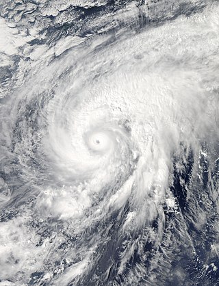
Typhoon Vongfong, known in the Philippines as Super Typhoon Ompong, was the most intense tropical cyclone worldwide in 2014, and struck Japan as a large tropical system. It also indirectly affected the Philippines and Taiwan. Vongfong was the nineteenth named storm and the ninth typhoon of the 2014 Pacific typhoon season. Estimates assess damage from Vongfong to have been over US$160 million, mainly for striking mainland Japan. At least 9 people were killed along the path of the typhoon in those countries.

<span class="mw-page-title-main">Typhoon Nuri (2014)</span> Pacific typhoon in 2014

Typhoon Nuri, known in the Philippines as Super Typhoon Paeng, was the third most intense tropical cyclone worldwide in 2014. Nuri developed into a tropical storm and received the name Paeng from the PAGASA on October 31, before it intensified into a typhoon on the next day. Under excellent conditions, especially the synoptic scale outflow, Nuri underwent rapid deepening and reached its peak intensity on November 2, forming a round eye in a symmetric Central dense overcast (CDO). Having maintained the impressive structure for over one day, the typhoon began to weaken on November 4, with a cloud-filled eye.

<span class="mw-page-title-main">Timeline of the 2015 Pacific typhoon season</span>

This timeline documents all of the events of the 2015 Pacific typhoon season. Most of the tropical cyclones formed between May and November. The scope of this article is limited to the Pacific Ocean, north of the equator between 100°E and the International Date Line. This area, called the Western Pacific basin, is the responsibility of the Japanese Meteorological Agency (JMA). They host and operate the Regional Specialized Meteorological Center (RSMC), located in Tokyo. The Japanese Meteorological Agency (JMA) is also responsible for assigning names to all tropical storms that are formed within the basin. However, any storm that enters or forms in the Philippine Area of Responsibility (PAR) will be named by the Philippine Atmospheric, Geophysical and Astronomical Services Administration (PAGASA) using a local name. Also of note - the Western Pacific basin is monitored by the United States' Joint Typhoon Warning Center (JTWC), which gives all Tropical depressions a number with a "W" suffix.

<span class="mw-page-title-main">Tropical Storm Mekkhala (2015)</span> Pacific typhoon in 2015

Severe Tropical Storm Mekkhala, known in the Philippines as Severe Tropical Storm Amang, was an early-season tropical cyclone that made landfall over the Philippines in January 2015. Mekkhala killed three people in the Bicol Region and caused light crop damage. Notably, the storm disturbed Pope Francis’ visit to the country after the victims of Typhoon Haiyan on November 8, 2013. Although the storm also caused an airplane crash in Tacloban, nobody was hurt in the incident.

<span class="mw-page-title-main">Typhoon Melor</span> Pacific typhoon in 2015

Typhoon Melor, known in the Philippines as Typhoon Nona, was a powerful tropical cyclone that struck the Philippines in December 2015. The twenty-seventh named storm and the eighteenth typhoon of the annual typhoon season, Melor killed 51 people and caused ₱7.04 billion in damage.

<span class="mw-page-title-main">Typhoon Haima</span> Pacific typhoon in 2016

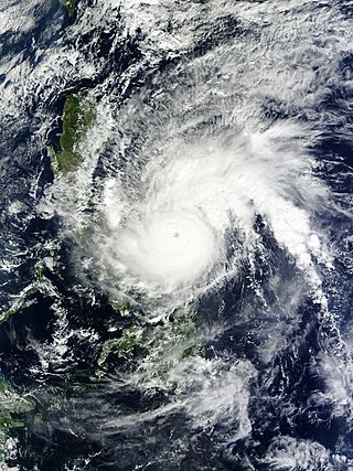
Typhoon Haima, known in the Philippines as Super Typhoon Lawin, was the third most intense tropical cyclone worldwide in 2016. It was the twenty-second named storm and the eleventh typhoon of the annual typhoon season. Impacting the Philippines less than 3 days after Typhoon Sarika, Haima formed out of a tropical disturbance southwest of Chuuk on October 14, it developed into a tropical storm the next day. Steady strengthening occurred over the next day or two as it tracked westward towards the Philippines. After forming an eye shortly after it was upgraded to a typhoon, Haima began to rapidly strengthen and eventually became a super typhoon on October 18. It later attained its peak intensity as a Category 5-equivalent tropical cyclone before weakening slightly. Haima later made landfall in Peñablanca, Cagayan late on October 19 as a Category 4-equivalent storm. Rapid weakening occurred as it interacted with the landmasses until it entered the Southern China Sea as a weak typhoon. It formed a large ragged eye once again and remained steady in intensity until making landfall in China on October 21. It weakened below typhoon intensity and became extratropical on October 22. The cyclone drifted northeastwards and later eastwards before emerging over water again, but eventually dissipated by October 26.

<span class="mw-page-title-main">Typhoon Nock-ten</span> Pacific typhoon in 2016

Typhoon Nock-ten, known in the Philippines as Super Typhoon Nina, was the strongest Christmas Day tropical cyclone worldwide in terms of 1-minute sustained winds. Forming as a tropical depression southeast of Yap and strengthening into the twenty-sixth tropical storm of the annual typhoon season on December 21, 2016, Nock-ten intensified into the thirteenth typhoon of the season on December 23. Soon afterwards, the system underwent explosive intensification and became a Category 5-equivalent super typhoon early on December 25. Nock-ten weakened shortly afterwards before making eight landfalls over the Philippines. The typhoon weakened rapidly due to the landfalls as it entered the South China Sea on December 26, turned southwest, and ultimately dissipated on December 28 due to the winter monsoon.

<span class="mw-page-title-main">Typhoon Nesat (2017)</span> Pacific typhoon in 2017

Typhoon Nesat, known in the Philippines as Typhoon Gorio, was a strong tropical cyclone that impacted Taiwan and Fujian, China. It was the ninth named storm and the second typhoon of the annual typhoon season. After consolidating slowly for several days, Tropical Storm Nesat developed east of the Philippines on July 25. While experiencing favorable environmental conditions such as very warm sea surface temperatures and low wind shear, Nesat strengthened into a typhoon and reached its peak intensity on July 28. On July 29, the typhoon made landfall near the Taiwanese city of Yilan, before weakening to a severe tropical storm and making landfall again near Fuqing on China's east coast late the same day. Moving into July 30, Nesat continued to weaken under the effects of land interaction.

<span class="mw-page-title-main">Typhoon Lan (2017)</span> Pacific typhoon in 2017

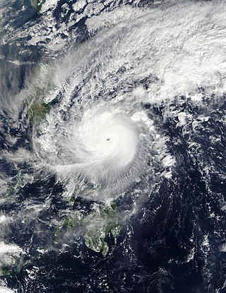
Typhoon Lan, known in the Philippines as Super Typhoon Paolo, was the third-most intense tropical cyclone worldwide in 2017, behind only hurricanes Irma and Maria in the Atlantic. A very large storm, Lan was the twenty-first tropical storm and ninth typhoon of the annual typhoon season. It originated from a tropical disturbance that the United States Naval Research Laboratory had begun tracking near Chuuk on October 11. Slowly consolidating, it developed into a tropical storm on October 15, and intensified into a typhoon on October 17. It expanded in size and turned northward on October 18, although the typhoon struggled to intensify for two days. On October 20, Lan grew into a very large typhoon and rapidly intensified, due to favorable conditions, with a large well-defined eye, reaching peak intensity as a "super typhoon" with 1-minute sustained winds of 249 km/h (155 mph) – a high-end Category 4-equivalent storm – late on the same day. Afterward, encroaching dry air and shear caused the cyclone to begin weakening and turn extratropical, before it struck Japan on October 23 as a weaker typhoon. Later that day, it became fully extratropical before it was absorbed by a larger storm shortly afterward.

<span class="mw-page-title-main">Tropical depressions Wilma and BOB 05</span> A series of tropical cyclones in 2013

Tropical Depression Wilma, also referred to as 30W and Depression BOB 05 were a series of tropical cyclones that traveled from the Northwest Pacific Ocean to the North Indian Ocean in 2013. Forming east of Palau on November 1, the tropical depression passed through the Philippines on November 4 and emerged into the South China Sea on the next day. Without intensification, the system made landfall over Vietnam on November 6 and arrived at the Gulf of Thailand on November 7.

References

  1. "SitRep No. 27 re Effects of Typhoon "Ruby" (Hagupit)" (PDF). National Disaster Risk Reduction and Management Council. December 19, 2014. Archived (PDF) from the original on December 19, 2014. Retrieved January 1, 2015.
  2. Freedman, Andrew (December 4, 2014). "Super Typhoon Hagupit poses deadly risks to Philippines, raises specter of Haiyan". Mashable. Retrieved January 1, 2015.
  3. (hə-goo-PEET, [hɐguˈpit]; Filipino word meaning "lashing or flogging")
  4. 1 2 "RSMC Tropical Cyclone Advisory – December 1, 2014 0600Z". Japan Meteorological Agency. Archived from the original on December 1, 2014. Retrieved December 5, 2014.
  5. 1 2 "RSMC Tropical Cyclone Advisory – December 2, 2014 1200Z". Japan Meteorological Agency. Archived from the original on December 4, 2014. Retrieved December 5, 2014.
  6. 1 2 "RSMC Tropical Cyclone Advisory – December 4, 2014 0600Z". Japan Meteorological Agency. Archived from the original on December 4, 2014. Retrieved December 5, 2014.
  7. 1 2 "Prognostic Reasoning for Typhoon 22W (Hagupit) Warning Nr 21". Joint Typhoon Warning Center. Archived from the original on December 11, 2014. Retrieved December 11, 2014.
  8. 1 2 "RubyPH Update: as of 09:15 PM, 06 December 2014". PAGASA. Retrieved December 8, 2014.
  9. 1 2 "Tropical Cyclone Advisory for Analysis and Forecast 2014-12-08T12:00:00Z". WIS Portal – GISC Tokyo. Japan Meteorological Agency. Retrieved December 11, 2014.
  10. 1 2 "Prognostic Reasoning for Tropical Storm 22W (Hagupit) Warning Nr 33". Joint Typhoon Warning Center. Archived from the original on December 11, 2014. Retrieved December 11, 2014.
  11. 1 2 "Tropical Cyclone Advisory for Analysis and Forecast 2014-12-11T12:00:00Z". WIS Portal – GISC Tokyo. Japan Meteorological Agency. Retrieved January 1, 2015.
  12. "Track file of Super Typhoon 22W (Hagupit)" (TXT). U.S. Naval Research Laboratory. Retrieved December 5, 2014.
  13. "Tropical Cyclone Formation Alert". Joint Typhoon Warning Center. Archived from the original on December 1, 2014. Retrieved December 5, 2014.
  14. "RSMC Tropical Cyclone Advisory – December 1, 2014 0000Z". Japan Meteorological Agency. Archived from the original on December 1, 2014. Retrieved December 5, 2014.
  15. "Tropical Depression 22W (Twentytwo) Warning Nr 001". Joint Typhoon Warning Center. Archived from the original on December 1, 2014. Retrieved December 5, 2014.
  16. "Prognostic Reasoning for Tropical Storm 22W (Twentytwo) Warning Nr 02". Joint Typhoon Warning Center. Archived from the original on December 1, 2014. Retrieved December 5, 2014.
  17. 1 2 "RSMC Tropical Cyclone Best Track Name 1422 Hagupit (1422)". Japan Meteorological Agency. Archived from the original on December 19, 2014. Retrieved January 9, 2015.
  18. "Prognostic Reasoning for Typhoon 22W (Hagupit) Warning Nr 07". Joint Typhoon Warning Center. Archived from the original on December 4, 2014. Retrieved December 5, 2014.
  19. "RSMC Tropical Cyclone Advisory – December 2, 2014 1800Z". Japan Meteorological Agency. Archived from the original on December 4, 2014. Retrieved December 5, 2014.
  20. "Prognostic Reasoning for Super Typhoon 22W (Hagupit) Warning Nr 12". Joint Typhoon Warning Center. Archived from the original on December 4, 2014. Retrieved December 5, 2014.
  21. "Weather Bulletin Number Two". PAGASA. Archived from the original on December 11, 2014. Retrieved December 11, 2014.
  22. "Prognostic Reasoning for Super Typhoon 22W (Hagupit) Warning Nr 13". Joint Typhoon Warning Center. Archived from the original on December 4, 2014. Retrieved December 5, 2014.
  23. "Super Typhoon 22W (Hagupit) Warning Nr 013". Joint Typhoon Warning Center. Archived from the original on December 4, 2014. Retrieved December 5, 2014.
  24. "Prognostic Reasoning for Super Typhoon 22W (Hagupit) Warning Nr 15". Joint Typhoon Warning Center. Archived from the original on December 10, 2014. Retrieved December 11, 2014.
  25. "Tropical Cyclone Advisory for Analysis and Forecast 2014-12-05T00:00:00Z". WIS Portal – GISC Tokyo. Japan Meteorological Agency. Retrieved December 11, 2014.
  26. "Prognostic Reasoning for Typhoon 22W (Hagupit) Warning Nr 17". Joint Typhoon Warning Center. Archived from the original on December 11, 2014. Retrieved December 11, 2014.
  27. "Tropical Cyclone Advisory for Analysis and Forecast 2014-12-05T12:00:00Z". WIS Portal – GISC Tokyo. Japan Meteorological Agency. Retrieved December 11, 2014.
  28. "Prognostic Reasoning for Super Typhoon 22W (Hagupit) Warning Nr 19". Joint Typhoon Warning Center. Archived from the original on December 11, 2014. Retrieved December 11, 2014.
  29. "Tropical Cyclone Advisory for Analysis and Forecast 2014-12-06T00:00:00Z". WIS Portal – GISC Tokyo. Japan Meteorological Agency. Retrieved December 11, 2014.
  30. "Severe Weather Bulletin No. 14". PAGASA. Retrieved December 8, 2014.
  31. "Tropical Cyclone Advisory for Analysis and Forecast 2014-12-07T21:00:00Z". WIS Portal – GISC Tokyo. Japan Meteorological Agency. Retrieved December 11, 2014.
  32. "Prognostic Reasoning for Tropical Storm 22W (Hagupit) Warning Nr 29". Joint Typhoon Warning Center. Archived from the original on December 11, 2014. Retrieved December 11, 2014.
  33. "Severe Weather Bulletin No. 18". PAGASA. Retrieved December 8, 2014.
  34. "RubyPH Update: as of 05:45 PM, 08 December 2014". PAGASA. Retrieved December 8, 2014.
  35. "Prognostic Reasoning for Tropical Storm 22W (Hagupit) Warning Nr 35". Joint Typhoon Warning Center. Archived from the original on December 11, 2014. Retrieved December 11, 2014.
  36. "Prognostic Reasoning for Tropical Storm 22W (Hagupit) Warning Nr 38". Joint Typhoon Warning Center. Archived from the original on December 11, 2014. Retrieved December 11, 2014.
  37. "Prognostic Reasoning for Tropical Storm 22W (Hagupit) Warning Nr 40". Joint Typhoon Warning Center. Archived from the original on December 11, 2014. Retrieved December 11, 2014.
  38. "Prognostic Reasoning for Tropical Storm 22W (Hagupit) Warning Nr 41". Joint Typhoon Warning Center. Archived from the original on December 13, 2014. Retrieved December 13, 2014.
  39. "Prognostic Reasoning for Tropical Depression 22W (Hagupit) Warning Nr 43". Joint Typhoon Warning Center. Archived from the original on December 13, 2014. Retrieved December 13, 2014.
  40. "Tropical Depression 22W (Hagupit) Warning Nr 45". Joint Typhoon Warning Center. Archived from the original on December 13, 2014. Retrieved December 13, 2014.
  41. "Marine Weather Warning for GMDSS Metarea XI 2014-12-12T06:00:00Z". WIS Portal – GISC Tokyo. Japan Meteorological Agency. Retrieved December 13, 2014.
  42. "Marine Weather Warning for GMDSS Metarea XI 2014-12-12T12:00:00Z". WIS Portal – GISC Tokyo. Japan Meteorological Agency. Retrieved December 13, 2014.
  43. "SitRep No. 01 re Preparedness Measures for TY "RUBY" (HAGUPIT)" (PDF). NDRRMC. Retrieved December 4, 2014.
  44. "SitRep No. 03 re Preparedness Measures for TY "RUBY" (HAGUPIT)" (PDF). NDRRMC. Retrieved December 5, 2014.
  45. "All hands on deck in govt hospitals in areas threatened by Ruby". GMA News. Trisha Macas. Retrieved December 5, 2014.
  46. "Signal No. 3 up over three provinces as Ruby moves toward Eastern Visayas". GMA News. Retrieved December 5, 2014.
  47. "Storm surge warnings up in 42 areas". GMA News. Retrieved December 5, 2014.
  48. "List of class and work suspensions for Dec. 5 and 6". GMA News. Retrieved December 5, 2014.
  49. "List of Dec. 8–9 class suspensions due to Typhoon Ruby". GMA News. Retrieved December 6, 2014.
  50. "Signal No. 2 raised over Metro Manila; NCR to feel Ruby's effects Monday evening". GMA News. Retrieved December 8, 2014.
  51. "SitRep No. 09 re Effects of TY "RUBY" (HAGUPIT)" (PDF). NDRRMC. Retrieved December 8, 2014.
  52. "Typhoon Ruby makes first landfall in Dolores, Eastern Samar". Philippine Daily Inquirer. Retrieved December 6, 2014.
  53. "Ruby makes second landfall, seven areas under Signal No. 3". GMA News. Retrieved December 7, 2014.
  54. "SitRep No. 27 re Effects of Typhoon "Ruby" (Hagupit)" (PDF). National Disaster Risk Reduction and Management Council. December 19, 2014. Archived (PDF) from the original on December 19, 2014. Retrieved January 1, 2015.
  55. "Ruby faces removal from storm list". Sun Star. Archived from the original on December 10, 2014. Retrieved December 20, 2014.
  56. "Pagasa kills names of killer typhoons". Philippine Daily Inquirer. February 8, 2015. Archived from the original on February 9, 2015. Retrieved February 9, 2015.
  57. "Philippine Tropical Cyclone Names". Philippine Atmospheric, Geophysical and Astronomical Services Administration. Archived from the original on February 1, 2015. Retrieved February 1, 2015.
Typhoon Hagupit (Ruby)
Hagupit 2014-12-04 0438Z.jpg
Typhoon Hagupit shortly before peak intensity on December 4