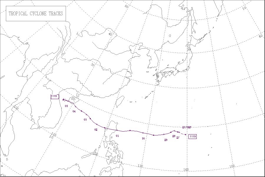
Typhoon Nalgae (2011)

Last updated
Map key
  Tropical depression (≤38 mph, ≤62 km/h)
  Tropical storm (39–73 mph, 63–118 km/h)
  Category 1 (74–95 mph, 119–153 km/h)
  Category 2 (96–110 mph, 154–177 km/h)
  Category 3 (111–129 mph, 178–208 km/h)
  Category 4 (130–156 mph, 209–251 km/h)
  Category 5 (≥157 mph, ≥252 km/h)
  Unknown
Storm type
Disc Plain black.svg Tropical cyclone
Solid black.svg Subtropical cyclone
ArrowUp.svg Extratropical cyclone, remnant low, tropical disturbance, or monsoon depression

On September 26, the Japan Meteorological Agency (JMA) started to monitor a weak tropical depression that had developed about 1,260 km (785 mi) to the northwest of Manila in the Philippines. [1] During that day, while the depression moved towards the northwest its low level circulation centre rapidly consolidated in an area of favourable conditions for further development of the system. This prompted the Joint Typhoon Warning Center (JTWC) to issue a tropical cyclone formation alert on the system early the next day. [2] However less than 3 hours later, the JTWC decided to issue advisories on the system designating it as Tropical Depression 22W, before the JMA reported that the depression had become a tropical storm and named it Nalgae. [1] [3] [4]

The storm slowly drifted to the west and kept on intensifying gradually. On September 29, microwave imagery showed Nalgae developed an eyelike feature and well defined convective banding in all the quadrants. The system had a tiny radius of winds, though it was still strengthening significantly and was very well defined. [5] On the evening of September 28, the JMA reported that Nalgae continued to intensify, as they upgraded it to a severe tropical storm with winds of over 55 knots (102 km/h; 63 mph). [6] On that night, the PAGASA initiated advisories on Nalgae, giving it the local name Quiel, as it entered the Philippine Area of Responsibility (PAR). [7]

On the morning of September 29, the JTWC reported that Nalgae developed a small microwave eye like feature and multiple convective bands wrapped tightly into the center. Using the Dvorak technique, the JTWC estimated the average 1-minute sustained wind speed of Nalgae to be at 65 knots (120 km/h; 75 mph). [8] On that evening, the JMA further upgraded Nalgae to a typhoon. [9] Nalgae continued to drift westwards at approximately 13 knots (24 km/h; 15 mph) and continued to intensify. On the night of September 29, Nalgae's outflow to the east got more enhanced and the outflow in all other directions remained radial. Nalgae was running west quite quickly because of a strong and a deep subtropical ridge located to the east of the system. The JTWC anticipated Nalgae to continually strengthen before it made landfall over Luzon, Philippines. [10] Continuing on its quick westward run, Nalgae developed a tiny 5 nautical miles (9.3 km; 5.8 mi) eye with a small break in the eyewall around the eastern periphery, because of a slight vertical wind shear as estimated by the JTWC. There was deep convective banding extending approximately 120 nautical miles (220 km; 140 mi) from the center and the overall outflow remained good. based on Dvorak intensity estimates, the winds of Nalgae were then raised to 95 knots (176 km/h; 109 mph). [11]

Preparations

Philippines

Typhoon Nalgae approaching the Philippines on September 30 Nalgae Sept 30 2011.jpg
Typhoon Nalgae approaching the Philippines on September 30

On September 30, the Americans living in Philippines were reminded by the United States government "to carry their travel documents at all times and secure them in a safe and waterproof location." The government launched the helpline numbers 1-888-407-4747 and 1-202-501-4444 so that the people traveling within the nation can obtain updated information from the Department of State. [12] Also, the PAGASA insisted all people living in the low-lying areas to leave immediately. The said that "Even areas that are currently not flooded are in danger because water from flooded communities will eventually seep into neighboring areas." [13] [14] The PAGASA hoisted public storm warning signal number 3 in Cagayan and Isabela as the storm drifted closer. They said that "The coming storm is expected to bring strong winds, but authorities are more concerned about the amount of rainfall it will pour." Fears worsened as the typhoon came 4 days after Typhoon Nesat devastated the same place and also lead to a state of calamity being declared. Five towns in Cagayan were still flooded and the same place was to be hit by Nalgae, which is much stronger than Nesat. [15]

Highest Public Storm Warning Signal

Typhoon Nalgae (Quiel)
Nalgae 2011-09-30 2332Z.png
Nalgae at peak intensity and making landfall in the Philippines late on September 30
IBTrACS OOjs UI icon edit-ltr-progressive.svg
PSWS#LUZONVISAYASMINDANAO
PSWS #3Isabela, Northern Aurora, Mt. Province, Ifugao, Nueva Vizcaya, Quirino, Benguet, Ilocos Sur, La Union, PangasinanNONENONE
PSWS #2Cagayan, Apayao, Ilocos Norte, Abra, Kalinga, rest of Aurora, Nueva Ecija, Tarlac, Pampanga, Zambales, Bulacan, Northern Quezon incl. Polillo IslandNONENONE
PSWS #1rest of Quezon, Camarines Norte, Rizal, Bataan, Cavite, Laguna, Batangas, Lubang Island, Babuyan Group of Islands, Calayan Group of Islands, Metro ManilaNONENONE

China

On October 3, the National Marine Environmental Forecasting Center of China upgraded the rainstorm alert for Typhoon Nalgae to the orange level, the second-highest alert level in the country's four-level rainstorm alert system, reporting that a number of tidal stations off the provinces of Hainan, Guangdong and Fujian would experience tides beyond the ordinary safety levels. The agency asked all the tourists heading to typhoon-hit provinces to remain flexible with their itineraries as several air and ship may be either cancelled or indefinitely delayed when the typhoon comes ashore. [16] [17] [ clarification needed ]

Impact

Philippines

Typhoon Nalgae over the Philippines on October 1 Nalgae 2011-10-01 0300Z.jpg
Typhoon Nalgae over the Philippines on October 1

Nalgae, the second typhoon hit Philippines within one week made landfall along the coast of Dinapigue town in Isabela province. The PAGASA weather bureau chief Graciano Yumul said that "The ground is still supersaturated and it cannot absorb more water. This will just flow down to rivers and towns, and there is a big possibility that landslides, flash flooding and flooding could occur." The search and rescue operations for Typhoon Nesat were halted because of the fierce weather brought by Nalgae. The NOLCOM chief Major General Jessie Dellosa said "Our rescue operations are ongoing with the use of watercraft and rubber boats. We are also continuously coordinating with the local government units to rescue the affected residents in Calumpit and Hagonoy." [18] The National Disaster Risk Reduction and Management Council director Benito Ramos said that thousands of rescue workers were deployed across Luzon and the island's sparsely populated northeast coast was evacuated following the orders from the president Benigno Aquino III. Ramous said "We're implementing persuasive evacuation operations. If I have to handcuff people to remove them from their homes I could be charged with human rights violations." [19] Nalgae was making a similar path across the saturated Luzon Island as Typhoon Nesat. The wind gusts brought by Nalgae toppled trees and blew away tin roofs of some houses in Isabela's provincial capital of Ilagan. Nalgae continued to worsen the flooding and destruction brought by Nesat. Nalgae was far more stronger than Nesat and plummeted the nation with more winds and rains. [20] The governor of Isabela province, Faustino Dy said that "Hundreds of people in coastal areas had been evacuated as rain and strong cut power lines, uprooted trees and blocked roads with debris." He added that "Nalgae could cause floods on Luzon's central plains before passing through La Union province, a tobacco-growing area, and then heading off into the South China Sea." Also, the PAGASA announced that an estimated 10–18 mm per hour of rains were experienced in several areas across the nation filling up dams and causing river systems to swell. [21] As the storm continued to move inland with strong winds, many structures including billboards, tarpaulins and wooden materials in the town of Cauayan were damaged. The barriers of the Isabela highway were also destroyed by the typhoon. The government responded quickly and cleared off all the debris on the highway and made it usable again. [22] According to the National Disaster Risk Reduction and Management Council (NDDRMC), the onslaught of the typhoon resulted in the death of 1 person living in the Mountain Province, a landlocked province of the Philippines in the Cordillera Administrative Region in Luzon. It was reported that Sonny Marcos, a passenger on board a passenger van was buried alongside the Halsema Highway, the highest altitude highway in the Philippines that stretches from Baguio to Bontoc, Mountain Province. [23]

[24] [25] Nalgae only took about six hours to blow through the Luzon island. Office of Civil Defense administrator Benito Ramos told "We are asking everyone still refusing to leave their homes to let authorities evacuate them. [26] The extremely strong winds blown by Nalgae set off a rockslide in northern Bontoc provincecausing boulders to roll down a mountainside and smash on a passing van, killing one man. In the rice-growing province of Bulacan north of Manila, several hundreds of people in several towns remained trapped on their rooftops as the floodwaters brought by Nesat never retreated and more flooding and rain was brought by Nalgae. Rescuers aboard rubber boats could not reach them because the alleyways were too narrow. Officials said that two army helicopters would be later deployed to rescue the victims. [27]

Quezon Avenue in Quezon City, during rainfall brought by Typhoon Nalgae Quezon Avenue 01.jpg
Quezon Avenue in Quezon City, during rainfall brought by Typhoon Nalgae

The province of Pampanga was badly affected - mainly due to the already prevailing floods from the previous typhoon Typhoon Nesat (Pedring). The floods continued till 5 October - much after the rains subsided. Boats were brought out to navigate the roads that had turned into rivers. The ground floor of most houses remained under water up to 4 days after Quiel passed.

Rescue efforts

The Rescue workers scrambled through the floodwaters on October 2, so that they could be able to deliver food, water and other relief materials to hundreds of villagers stuck on rooftops since several days after the twin typhoons ravaged the nation. Seven towns north of Manila including Calumpit in rice-growing Bulacan province continued to be under waist-high waters after the rains brought by Nalgae, the 17th tropical cyclone to affect the disaster-prone nation in 2011. Helicopters were able to deliver food via air, but could rescue none of those who were on the rooftops since 4 days. [28] The main problem with the evacuations was such that most of the victims refused to leave. The residents could do nothing but wade through the floodwaters, only to find the town hall completely submerged in water. [29] AirAsia, a Malaysian-based low-cost airline said that they would provide free aid to the victims of the twin typhoons in the Philippines. They announced that they would allocate special space in their cargo on its daily Manila bound flight. They also asked people who were interested to donate for the Filipinos could contact them at their email address, airasiacares@airasia.com. [30] [31]

On October 3, Philippine authorities rushed aid to thousands of people marooned in their flooded homes for a week since Nesat and Nalgae together battered the nation. After a long time, the flood water slowly started receding and the rescue workers were able to deliver food and other relief materials to those in need. In Calumpit. one of the worst hit towns, a construction worker in line for receiving the relief materials said to a new agency, "We have no food to eat, and no clean drinking water." [32] Although floodwaters have begun to subside, thousands of families continued to stay in the evacuation centers as more than 43,000 houses were damaged by the typhoon Nesat alone. In the Pampanga province the typhoon breached several dikes or small channels developed for the flow of drain water. The destructive landslides brought by Nalgae cut off large portions of the Philippine highways isolating the town of Carranglan in Nueva Ecija. [33] Also, after the water receded, most of the victims refused to leave their homes and head for the evacuation centers as they feared that their houses could be easily robbed in such a situation. They asked for food and relief materials to be delivered to their house instead. [34] It was later reported that at least 8 million people living in the Philippines have experience faced much worse floods than the earlier destruction caused by typhoon Nesat. The disaster management chief Benito Ramos said "The fight is not over yet. I hope the (Nesat) floods will wash out to Manila Bay before the (Nalgae) runoff hits the area. If the latter catches up to the former, there won’t be any rooftops left to see above the floodwaters." The local weather agency announced that the water levels on the tributaries of major central Luzon rivers were still continuing to rise fast and posed a threat to the nearby towns and villages. [35]

See also

Related Research Articles

<span class="mw-page-title-main">2005 Pacific typhoon season</span> Typhoon season in the Western Pacific Ocean

The 2005 Pacific typhoon season was the least active typhoon season since 2000, producing 23 named storms, of which 13 became typhoons. It was an event in the annual cycle of tropical cyclone formation, in which tropical cyclones form in the western Pacific Ocean. The season ran throughout 2005, though most tropical cyclones typically develop between May and October. The season's first named storm, Kulap, developed on January 13, while the season's last named storm, Bolaven, dissipated on November 20. The season's first typhoon, Haitang, reached typhoon status on July 13, and became the first super typhoon of the year three days later.

<span class="mw-page-title-main">2007 Pacific typhoon season</span> Typhoon season in the Western Pacific Ocean

The 2007 Pacific typhoon season was a below average season which featured 24 named storms, fourteen typhoons, and five super typhoons. It was an event in the annual cycle of tropical cyclone formation, in which tropical cyclones form in the western Pacific Ocean. The season ran throughout 2007, though most tropical cyclones typically develop between May and November. The season's first named storm, Kong-rey, developed on March 30, while the season's last named storm, Mitag, dissipated on November 27. The season's first typhoon, Yutu, reached typhoon status on May 18, and became the first super typhoon of the year on the next day.

<span class="mw-page-title-main">Tropical Storm Halong (2008)</span> Pacific severe tropical storm in 2008

Severe Tropical Storm Halong, known in the Philippines as Typhoon Cosme, was the fourth severe tropical storm named by the Japan Meteorological Agency (JMA), which is the Regional Specialized Meteorological Centre for the Northwestern Pacific Ocean. The Joint Typhoon Warning Center also recognized Halong as the fifth tropical depression, the fourth tropical storm, as well as the third typhoon of the 2008 Pacific typhoon season.

<span class="mw-page-title-main">Tropical Storm Kammuri (2008)</span> Pacific severe tropical storm in 2008

Severe Tropical Storm Kammuri, known in the Philippines as Tropical Storm Julian, was a storm which made landfall on south China in August 2008, having a maximum wind speed of 50 kn (93 km/h). The name Kammuri was submitted to the World Meteorological Organisation's Typhoon Committee by Japan and is Japanese for the Corona Borealis constellation of stars.

<span class="mw-page-title-main">Typhoon Rammasun (2008)</span> Pacific typhoon in 2008

Typhoon Rammasun, known in the Philippines as Typhoon Butchoy, was recognized as the second typhoon of the 2008 Pacific typhoon season by the Japan Meteorological Agency (JMA) and the Philippine Atmospheric, Geophysical and Astronomical Services Administration (PAGASA). Rammasun was also recognised as the third tropical storm, the second typhoon and the first super typhoon of the 2008 Pacific typhoon season by the Joint Typhoon Warning Center (JTWC).

<span class="mw-page-title-main">Typhoon Nuri (2008)</span> Pacific typhoon in 2008

Typhoon Nuri, known in the Philippines as Typhoon Karen, was the 12th named storm and the seventh typhoon that was recognised by the Japan Meteorological Agency. The Joint Typhoon Warning Center recognised it as the 13th tropical depression, the 12th tropical storm and the 8th typhoon of the 2008 Pacific typhoon season. The name Nuri was submitted to the World Meteorological Organisation's Typhoon Committee by Malaysia in 2003 after the name Rusa was retired in 2002. The name Nuri is Malay for a blue crowned parroquet, a type of parrot. The name Karen was assigned by PAGASA to a tropical depression for the second time, the other time being in 2004 to Typhoon Rananim.

<span class="mw-page-title-main">Typhoon Sinlaku (2008)</span> Pacific typhoon in 2008

Typhoon Sinlaku, known in the Philippines as Typhoon Marce, was a typhoon which affected the Philippines, Taiwan, China and Japan. It was recognised as the 13th named storm and the ninth typhoon of the 2008 Pacific typhoon season by the Japan Meteorological Agency.

<span class="mw-page-title-main">Tropical Storm Maysak (2008)</span> Pacific severe tropical storm in 2008

Severe Tropical Storm Maysak, known in the Philippines as Tropical Storm Quinta-Siony, was recognised as the 19th tropical storm by the Japan Meteorological Agency. It was also recognised as the 24th tropical depression and the 22nd tropical storm by the Joint Typhoon Warning Center of the 2008 Pacific typhoon season.

<span class="mw-page-title-main">2009 Pacific typhoon season</span> Typhoon season in the Western Pacific Ocean

The 2009 Pacific typhoon season was a below average season that spawned only 22 named storms, 13 typhoons, and five super typhoons. It was also recognized as the deadliest season in the Philippines for decades. The first half of the season was very quiet whereas the second half of the season was extremely active. The season's first named storm, Kujira, developed on May 3 while the season's last named storm, Nida, dissipated on December 3.

<span class="mw-page-title-main">Typhoon Chan-hom (2009)</span> Pacific typhoon in 2009

Typhoon Chan-hom, known in the Philippines as Typhoon Emong, was the sixth tropical depression and the second tropical storm to develop during the 2009 Pacific typhoon season. Chan-hom developed out of an area of convectional cloudiness associated with an area of disturbed weather which originated from the remnants of Tropical Depression Crising and formed southeast of Nha Trang, Vietnam on May 2. Moving towards the northeast, it slowly organized according to JTWC who issued a TCFA, and JMA classified Chan-hom as a minor tropical depression later that day. The next day, both JTWC and JMA upgraded the depression to a tropical storm and named it Chan-hom. On May 6, the storm intensified into a Category 1 typhoon, and on May 7, Chan-hom intensified into a Category 2 typhoon equivalent. However, Chan-hom weakened into a severe tropical storm after passing northern Luzon. On May 14, Chan-hom regenerated into a Tropical Depression, before dissipating late on May 15.

<span class="mw-page-title-main">Tropical Storm Mujigae</span> Pacific tropical storm in 2009

Tropical Storm Mujigae, known in the Philippines as Tropical Depression Maring was a tropical storm that affected the Philippines, China, Hong Kong, and Vietnam in September 2009. Mujigae originated from an area of convection that developed along with a monsoon trough with favorable conditions on 8 September. The disturbance would organize to a tropical depression and be assigned the names 14W by the Joint Typhoon Warning Center and Maring by PAGASA later that day. Tropical Depression 14W would rapidly develop and attain tropical storm status by the JMA and be assigned the name Mujigae on 10 September. Mujigae would later encounter unfavorable conditions with wind shear and make landfall in Hainan Island on 11 September and Vietnam on 12 September before rapidly weakening and dissipating.

<span class="mw-page-title-main">2011 Pacific typhoon season</span> Typhoon season in the Western Pacific Ocean

The 2011 Pacific typhoon season was a below average season that produced a total of 21 named storms, 8 typhoons, and four super typhoons. This season was much more active than the previous season, although both seasons were below the Pacific typhoon average of 26. The season ran throughout 2011, though most tropical cyclone tend to develop between May and October. The season's first named storm, Aere, developed on May 7 while the season's last named storm, Washi dissipated on December 19.

<span class="mw-page-title-main">2017 Pacific typhoon season</span> Typhoon season in the Western Pacific Ocean

The 2017 Pacific typhoon season was a below-average season in terms of accumulated cyclone energy and the number of typhoons and super typhoons, and the first since the 1977 season to not produce a Category 5-equivalent typhoon on the Saffir–Simpson scale. The season produced a total of 27 named storms, 11 typhoons, and only two super typhoons, making it an average season in terms of storm numbers. It was an event in the annual cycle of tropical cyclone formation, in which tropical cyclones form in the western Pacific Ocean. The season runs throughout 2017, though most tropical cyclones typically develop between May and October. The season's first named storm, Muifa, developed on April 25, while the season's last named storm, Tembin, dissipated on December 26. This season also featured the latest occurrence of the first typhoon of the year since 1998, with Noru reaching this intensity on July 23.

<span class="mw-page-title-main">Typhoon Nanmadol (2011)</span> Pacific typhoon in 2011

Typhoon Nanmadol, known in the Philippines as Super Typhoon Mina, was the strongest tropical cyclone in 2011 to hit the Philippines and also the second most intense tropical cyclone worldwide in 2011, and the first of the year to directly impact Taiwan and the rest of the Republic of China (ROC). Becoming the eleventh named storm, the seventh severe tropical storm and the fourth typhoon of the 2011 Pacific typhoon season, Nanmadol made a total of three landfalls killing 26, and causing widespread damage worth US$26,464,591. The area of low pressure that was about to become Nanmadol formed on August 19. It drifted north and became a tropical depression on August 21, a tropical storm on August 23 and a typhoon on the same night. Nanmadol reached peak strength with winds of 105 knots and 140 knots threatening the Philippines with heavy rain and flash flooding.

<span class="mw-page-title-main">Typhoon Nesat (2011)</span> Pacific typhoon in 2011

Typhoon Nesat, known in the Philippines as Typhoon Pedring, was the most powerful tropical cyclone to directly impact China since 2005. It also struck the Philippines during the 2011 Pacific typhoon season, killing 98 people. It is the 17th named storm, the 11th severe tropical storm, the 7th typhoon and overall, the 30th tropical cyclone to be monitored by the Japan Meteorological Agency(JMA) during the year. Nesat came exactly two years after Typhoon Ketsana made landfall in the Philippines as the most devastating typhoon in the 2009 Pacific typhoon season with a damage of US$1.09 billion and 747 fatalities. Nesat was also the first of twin tropical cyclones to batter the Philippines within one week during September 2011, the second was Nalgae.

<span class="mw-page-title-main">Tropical Storm Rumbia (2013)</span> Pacific severe tropical storm in 2013

Severe Tropical Storm Rumbia, known in the Philippines as Tropical Storm Gorio, was a tropical cyclone that brought widespread flooding in areas of the Philippines and China late June and early July 2013. The sixth internationally named storm of the season, Rumbia formed from a broad area of low pressure situated in the southern Philippine Sea on June 27. Steadily organizing, the initial tropical depression moved towards the northwest as the result of a nearby subtropical ridge. On June 28, the disturbance strengthened to tropical storm strength, and subsequently made its first landfall on Eastern Samar in the Philippines early the following day. Rumbia spent roughly a day moving across the archipelago before emerging into the South China Sea. Over open waters, Rumbia resumed strengthening, and reached its peak intensity with winds of 95 km/h (50 mph) on July 1, ranking it as a severe tropical storm. The tropical cyclone weakened slightly before moving ashore the Leizhou Peninsula late that day. Due to land interaction, Rumbia quickly weakened into a low pressure area on July 2 and eventually dissipated soon afterwards.

<span class="mw-page-title-main">Typhoon Chebi (2006)</span> Pacific typhoon in 2006

Typhoon Chebi, known in the Philippines as Typhoon Queenie, was a powerful typhoon that impacted Luzon during November 2006. Chebi is the third typhoon since Typhoon Xangsane to hit the country destructively. The 30th tropical depression developed east of the Mariana Islands on October 31 as a weak disturbance. The system was dubbed into a tropical depression on November 8, until both the JMA and PAGASA upgraded it to a tropical storm on November 9. Chebi rapidly intensified to a Category 4 typhoon the next day and made landfall over northern Philippines on November 11. The system finally dissipated near Hong Kong and Vietnam on November 14.

<span class="mw-page-title-main">Timeline of the 2011 Pacific typhoon season</span>

This timeline documents all of the events of the 2011 Pacific typhoon season, the period that tropical cyclones formed in the Western Pacific Ocean in 2011. Most of the tropical cyclones formed between May and November 2011. The scope of this article is limited to the Pacific Ocean, north of the equator between 100°E and the International Date Line. Tropical storms that form in the entire Western Pacific basin are assigned a name by the Japan Meteorological Agency (JMA). Tropical depressions that form in this basin are given a number with a "W" suffix by the United States' Joint Typhoon Warning Center (JTWC). In addition, the Philippine Atmospheric, Geophysical and Astronomical Services Administration (PAGASA) assigns names to tropical cyclones that enter or form in the Philippine area of responsibility. These names, however, are not in common use outside of the Philippines.

<span class="mw-page-title-main">2022 Pacific typhoon season</span> Typhoon season in the Western Pacific Ocean

The 2022 Pacific typhoon season was the third consecutive season to have below-average tropical cyclone activity, with twenty-five named storms, of which ten became typhoons, and three intensified into super typhoons. The season saw a slightly below average activity by named storm count, although many of the storms were weak and short-lived, particularly towards the end of the season. This low activity was caused by an unusually strong La Niña that had persisted from 2020. The season's first named storm, Malakas, developed on April 6, while the last named storm, Pakhar, dissipated on December 12. The season's first typhoon, Malakas, reached typhoon status on April 12. The season ran throughout 2022, though most tropical cyclones typically develop between May and October. Tropical storms Megi and Nalgae were responsible for more than half of the casualties, while typhoons Hinnamnor and Nanmadol both caused $1 billion in damages.

<span class="mw-page-title-main">Tropical Storm Nalgae</span> Pacific severe tropical storm in 2022

Severe Tropical Storm Nalgae, known in the Philippines as Severe Tropical Storm Paeng, was a very large and deadly tropical cyclone that wreaked havoc across the Philippines and later impacted Hong Kong and Macau. Nalgae, meaning wing in Korean, the twenty-second named storm of the 2022 Pacific typhoon season, Nalgae originated from an invest located east of the Philippines on October 26. The disturbance, initially designated as 93W, was eventually upgraded the following day to a tropical depression by the Joint Typhoon Warning Center (JTWC) and re-designated as 26W. The Japan Meteorological Agency (JMA) however, had already considered the disturbance as a tropical depression a day prior to JTWC's; the Philippine Atmospheric, Geophysical and Astronomical Services Administration (PAGASA) also followed the JMA's lead and gave it the name Paeng. That same day, it was upgraded again by the JMA to tropical storm status, thus gaining the name Nalgae. The next day, the PAGASA and the JTWC upgraded Nalgae to a severe tropical storm status on October 28. Nalgae would eventually made its first landfall in Virac, Catanduanes, which was quickly followed by another landfall thirty minutes later. It then traversed the Bicol Region and emerged into Ragay Gulf, eventually making another landfall. Defying initial forecasts, Nalgae then moved southwestward and struck Mogpog. Afterwards, the storm moved northwestward into the Sibuyan Sea and struck Sariaya. Then it would move through many regions throughout the evening of October 29. Nalgae emerged over the West Philippine Sea the next day and weakened below tropical storm status. The storm would later re-intensify into a severe tropical storm a few hours later, and eventually exited the Philippine Area of Responsibility a day later. Upon its exit from Philippine jurisdiction, Nalgae then intensified into a Category 1-equivalent typhoon on JTWC; however, the JMA maintained its severe tropical storm classification for the system. It then approached the Pearl River Delta. At around 04:50 CST on November 3, 2022, Nalgae made its final landfall at Xiangzhou District as a tropical depression.

References

  1. 1 2 Unattributed (2011-11-14). "RSMC Tropical Cyclone Best Track: Typhoon Nalgae". Regional Specialised Meteorological Center Tokyo, Japan. Japan Meteorological Agency. Archived from the original on October 20, 2011. Retrieved 2011-12-30.{{cite web}}: CS1 maint: unfit URL (link)
  2. Unattributed (2011-09-27). "Tropical Cyclone Formation Alert 2011-09-27 06z". Joint Typhoon Warning Center. United States Navy, United States Air Force. Archived from the original on 2011-12-30. Retrieved 2011-09-29.
  3. Unattributed (2011-09-27). "JTWC Tropical Depression 22W Warning 2011-09-27 09z". Joint Typhoon Warning Center. United States Navy, United States Air Force. Archived from the original on September 28, 2011. Retrieved 2011-09-29.{{cite web}}: CS1 maint: unfit URL (link)
  4. "RSMC Tropical Cyclone Advisory Tropical Storm Nalgae 2011-09-27 18z". Japan Meteorological Agency. 2011-09-27. Archived from the original on September 28, 2011. Retrieved 2011-09-29.{{cite web}}: CS1 maint: unfit URL (link)
  5. "JTWC - Tropical Cyclone Advisory 07 - Typhoon Nalgae". Joint Typhoon Warning Center. Archived from the original on September 29, 2011. Retrieved 29 September 2011.{{cite web}}: CS1 maint: unfit URL (link)
  6. "JMA - Tropical Cyclone Advisory 281800 - Typhoon Nalgae". Japan Meteorological Agency. Archived from the original on September 29, 2011. Retrieved 29 September 2011.{{cite web}}: CS1 maint: unfit URL (link)
  7. "Severe Weather Bulletin Number ONE - Tropical Storm "QUIEL"". Philippine Atmospheric, Geophysical and Astronomical Services Administration. Archived from the original on September 29, 2011. Retrieved 29 September 2011.{{cite web}}: CS1 maint: unfit URL (link)
  8. "JTWC - Tropical Cyclone Advisory 09 - Typhoon Nalgae". Joint Typhoon Warning Center. Archived from the original on October 1, 2011. Retrieved 4 October 2011.{{cite web}}: CS1 maint: unfit URL (link)
  9. "JMA - Tropical Cyclone Advisory 291800 - Typhoon Nalgae". Japan Meteorological Agency. Archived from the original on September 30, 2011. Retrieved 4 October 2011.{{cite web}}: CS1 maint: unfit URL (link)
  10. "JTWC - Tropical Cyclone Advisory 11 - Typhoon Nalgae". Joint Typhoon Warning Center. Archived from the original on October 1, 2011. Retrieved 4 October 2011.{{cite web}}: CS1 maint: unfit URL (link)
  11. "JTWC - Tropical Cyclone Advisory 13 - Typhoon Nalgae". Joint Typhoon Warning Center. Archived from the original on October 1, 2011. Retrieved 4 October 2011.{{cite web}}: CS1 maint: unfit URL (link)
  12. "Americans cautioned over possible 'Quiel' onslaught". Philstar Global Corp. Retrieved 30 September 2011.
  13. "Leave now! PAGASA tells residents in flooded areas". ABS-CBN Interactive. Retrieved 30 September 2011.
  14. "More troops deployed in Central Luzon for rescue". ABS-CBN Interactive. Retrieved 30 September 2011.
  15. "Cagayan braces for Typhoon Quiel". ABS-CBN Interactive. Retrieved 30 September 2011.
  16. "China upgrades rainstorm alert as Typhoon Nalgae approaches". Xinhua News Agency. Archived from the original on October 5, 2011. Retrieved 4 October 2011.
  17. "Emergency teams sent to guard against Nalgae". China Daily. Retrieved 4 October 2011.
  18. "'Quiel' now sweeping northern Luzon areas". Philstar Global Corp. Retrieved 1 October 2011.
  19. "'Quiel' slams Northern Luzon; Signal no. 1 in Metro Manila". Inquirer. October 2011. Retrieved 1 October 2011.
  20. "New Typhoon Lashes Philippines". Dow Jones & Company, Inc. Archived from the original on October 2, 2011. Retrieved 1 October 2011.
  21. "Power down as Typhoon Naglae hits Philippines north". Thomson Reuters. 1 October 2011. Retrieved 1 October 2011.
  22. "Typhoon 'Quiel' batters Isabela". ABS-CBN Interactive. Retrieved 1 October 2011.
  23. "'Quiel' slightly weakens as it exits PH". ABS-CBN Interactive. Retrieved 1 October 2011.
  24. "Palace seeks boats, volunteers to help typhoon, flood victims". GMA Network Inc. Retrieved 2 October 2011.
  25. "At Least One Dead as Second Typhoon Batters Philippines". The New York Times Company. 1 October 2011. Retrieved 2 October 2011.
  26. "Philippines struggles in typhoon aftermath". DAWN.COM. 2 October 2011. Retrieved 2 October 2011.
  27. "Typhoons leave dozens dead in Philippines". USA TODAY. 2 October 2011. Retrieved 2 October 2011.
  28. "Filipinos still trapped on roofs; typhoons kill 55". CBS Interactive Inc. Archived from the original on October 3, 2011. Retrieved 2 October 2011.
  29. "Twin typhoons leave Philippines reeling". ABC News. ABC Online. 2 October 2011. Retrieved 2 October 2011.
  30. "Airasia Offers Free Delivery Of Aid To Typhoon Nesat Victims In The Philippines". Bernama. Retrieved 2 October 2011.
  31. "Philippines hit by back-to-back typhoons that leave dozens dead". Cable News Network (CNN). 2 October 2011. Retrieved 2 October 2011.
  32. "Aid rushed to Philippine flood victims in the wake of deadly typhoons". Singapore Press Holdings Ltd. Retrieved 3 October 2011.
  33. "Death toll from dual Philippine typhoons now 59". Cable News Network (CNN). 3 October 2011. Retrieved 3 October 2011.
  34. "Floods recede slowly in storm-battered Philippines". CBS Interactive Inc. Archived from the original on October 3, 2011. Retrieved 3 October 2011.
  35. "Second typhoon slams Philippines". Vancouver Sun. Retrieved 3 October 2011.