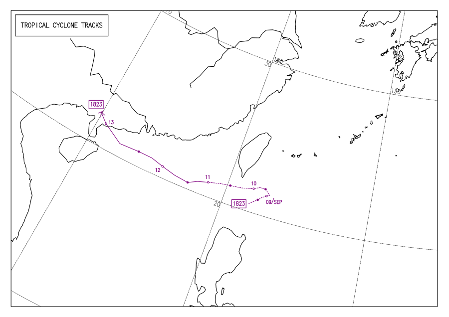
Tropical Storm Barijat (2018)

Last updated
Map key
  Tropical depression (≤38 mph, ≤62 km/h)
  Tropical storm (39–73 mph, 63–118 km/h)
  Category 1 (74–95 mph, 119–153 km/h)
  Category 2 (96–110 mph, 154–177 km/h)
  Category 3 (111–129 mph, 178–208 km/h)
  Category 4 (130–156 mph, 209–251 km/h)
  Category 5 (≥157 mph, ≥252 km/h)
  Unknown
Storm type
Disc Plain black.svg Tropical cyclone
Solid black.svg Subtropical cyclone
ArrowUp.svg Extratropical cyclone, remnant low, tropical disturbance, or monsoon depression

On September 6 at 06:00 UTC, the Joint Typhoon Warning Center (JTWC) began monitoring an area of convection approximately 140 nautical miles (260 km; 160 mi) southwest of Manila, assessing its development potential as low. [1] The next day at 20:00 UTC, its development potential was upgraded to medium as it continued northeastward, with satellite imagery depicting a partially exposed low-level circulation. [2] The system continued northeastwards, and on September 8 at 06:00 UTC, both the JMA and the PAGASA assessed that the system had developed into a tropical depression, [3] with the PAGASA assigning it the local name Neneng as the system was located inside the agency's area of responsibility. [4] Later that day at 19:30 UTC, the JTWC issued a Tropical Cyclone Formation Alert for the system, [5] and on September 9 at 06:00 UTC, the JTWC upgraded the system to a tropical depression, giving it the designation 27W, [6] after which the system abruptly turned westward over the Bashi Channel. [4] Infrared satellite imagery at 21:00 UTC showed a partially-exposed circulation center with deep convection over the southern portion of the storm. [7]

The depression continued westward, being steered by a low to mid-level subtropical ridge, and on September 10 at 06:00 UTC, the JTWC upgraded 27W to a tropical storm as it was located approximately 80 nautical miles (150 km; 90 mi) south-southeast of Kaohsiung. [6] [8] 27W was located in a favorable environment with high sea surface temperatures, [9] with infrared satellite imagery showing a small storm and flaring convection obscuring its circulation. [10] 27W left the PAGASA's area of responsibility at 14:00 UTC, [4] and on September 11 at 00:00 UTC, the JMA upgraded the depression to a tropical storm, assigning it the name Barijat. [3] Hours later at 06:00 UTC, both the JMA and the JTWC assessed Barijat to have peaked, with the JMA estimating 10-minute sustained winds of 75 km/h (45 mph) [3] and the JTWC estimating 1-minute sustained winds of 85 km/h (50 mph). [6] Barijat continued westward under marginally favorable conditions, [11] before weakening slightly the next day. [6] Enhanced infrared satellite imagery showed that Barijat's circulation became partially exposed, [12] and on September 12 at 00:30 UTC, Barijat made landfall over Zhanjiang, [13] with satellite imagery showing weak convection being sheared, completely exposing the circulation center. [14] On the next day at 06:00 UTC, both the JMA and the JTWC downgraded Barijat to a tropical depression, with the JTWC downgrading Barijat to a tropical disturbance and the JMA assessing Barijat to have dissipated 6 hours later. [3] [6]

Preparations and impact

Philippines

Barijat's precursor brought rains over northern Luzon, enhancing the southwest monsoon in the process. [15] It also brought gusty winds and heavy rains to the province of Batanes and to the Babuyan Islands, with the PAGASA raising Tropical Cyclone Wind Signal No. #1 over Batanes. The PAGASA advised residents living in the affected areas to take precautions against flooding and landslides, [16] with fishermen and other people with small vessels being advised against sailing in the area. [17] Barijat caused several landslides in Batanes, with floods entering schools and creeks overflowing. [18] Barijat brought increased risk of flooding and landslides in the provinces of Batanes, Cagayan, and Isabela, with the soil saturation worsening the effects of Typhoon Mangkhut. [19]

China

The weather bureau of Hainan issued an alert against strong gales and downpours. [20] 40 thousand residents were evacuated in the cities of Zhanjiang and Maoming, [21] with passenger and train services being halted due to safety concerns. [22] 11 thousand fishermen, 32 thousand offshore workers, and 36 thousand boats were brought back to land. [23] In Macau, there was no significant disruption to the city's activities. [24] Damages in China were estimated at ¥50 million (US$7.3 million). [25]

Vietnam

The northern parts of Vietnam were warned of possible flash flooding. [26]

See also

Related Research Articles

<span class="mw-page-title-main">2012 Pacific typhoon season</span>

The 2012 Pacific typhoon season was a slightly above average season that produced 25 named storms, fourteen typhoons, and four intense typhoons. It was a destructive and the second consecutive year to be the deadliest season, primarily due to Typhoon Bopha which killed 1,901 people in the Philippines. It was an event in the annual cycle of tropical cyclone formation, in which tropical cyclones form in the western Pacific Ocean. The season ran throughout 2012, though most tropical cyclones typically develop between May and October. The season's first named storm, Pakhar, developed on March 28, while the season's last named storm, Wukong, dissipated on December 29. The season's first typhoon, Guchol, reached typhoon status on June 15, and became the first super typhoon of the year on June 17.

<span class="mw-page-title-main">2015 Pacific typhoon season</span>

The 2015 Pacific typhoon season was a slightly above average season that produced twenty-seven tropical storms, eighteen typhoons, and nine super typhoons. The season ran throughout 2015, though most tropical cyclones typically develop between May and November. The season's first named storm, Mekkhala, developed on January 15, while the season's last named storm, Melor, dissipated on December 17. The season saw at least one named tropical system forming in each of every month, the first time since 1965. Similar to the previous season, this season saw a high number of super typhoons. Accumulated cyclone energy (ACE) during 2015 was extremely high, the third highest since 1970, and the 2015 ACE has been attributed in part to anthropogenic warming, and also the 2014-16 El Niño event, that led to similarly high ACE values in the East Pacific.

<span class="mw-page-title-main">2018 Pacific typhoon season</span>

The 2018 Pacific typhoon season was at the time, the costliest Pacific typhoon season on record, until the record was beaten by the following year. The season was well above-average, producing twenty-nine storms, thirteen typhoons, seven super typhoons and six Category 5 tropical cyclones. The season ran throughout 2018, though most tropical cyclones typically develop between May and October. The season's first named storm, Bolaven, developed on January 3, while the season's last named storm, Man-yi, dissipated on November 28. The season's first typhoon, Jelawat, reached typhoon status on March 29, and became the first super typhoon of the year on the next day.

<span class="mw-page-title-main">Timeline of the 2013 Pacific typhoon season</span>

Most of the tropical cyclones of the 2013 Pacific typhoon season formed between May and November of that year. The scope of this article is the Pacific Ocean north of the equator, between 100°E and the International Date Line. Tropical storms which form in the Western Pacific basin are assigned a name by the Japan Meteorological Agency (JMA). Tropical depressions forming in this basin are given a number with a "W" suffix by the United States' Joint Typhoon Warning Center (JTWC). The Philippine Atmospheric, Geophysical and Astronomical Services Administration (PAGASA) assigns names to tropical cyclones that enter or form in the Philippine area of responsibility, but these names are not in common use outside the Philippines.

<span class="mw-page-title-main">Timeline of the 2012 Pacific typhoon season</span>

This timeline documents all of the events of the 2012 Pacific typhoon season. The scope of this article is limited to the Pacific Ocean, north of the equator between 100°E and the International Date Line. During the season, 34 systems were designated as tropical depressions by either the Japan Meteorological Agency (JMA), the Philippine Atmospheric, Geophysical and Astronomical Services Administration (PAGASA), the Joint Typhoon Warning Center (JTWC), or other National Meteorological and Hydrological Services such as the China Meteorological Administration and the Hong Kong Observatory. Since the JMA runs the Regional Specialized Meteorological Centre (RSMC) for the Western Pacific, they assigned names to tropical depressions which developed into tropical storms in the basin. PAGASA also assigned local names to systems which are active in their area of responsibility; however, these names are not in common use outside of the Philippines.

<span class="mw-page-title-main">Typhoon Phanfone (2014)</span> Pacific typhoon in 2014

Typhoon Phanfone, known in the Philippines as Typhoon Neneng, was a powerful tropical cyclone which affected Japan in early October 2014. It was the eighteenth named storm and the eighth typhoon of the 2014 Pacific typhoon season. Phanfone started as a large area of convection well west of the International Date Line. The system was well organized and classified as Tropical Depression 18W on September 29. At the same day, it gained the name Phanfone due to very favorable conditions and intense thunderstorms rich with convection surrounding the storm's center. Phanfone would later go rapid intensification on October 1 due to warm sea-surface temperatures and very favorable environments. JTWC upgraded Phanfone to a Category 4 typhoon but weakened later back to Category 3 due to its eye replacing the old one and undergoing a minor eyewall replacement cycle.

<span class="mw-page-title-main">Tropical Storm Kujira (2015)</span> 2015 Pacific tropical storm

Tropical Storm Kujira was a tropical cyclone that prompted the PAGASA to declare the beginning of the rainy season in the Philippines. The ninth tropical depression, 8th named storm, and first storm to make landfall on China in the 2015 Pacific typhoon season, it formed as a tropical depression south of the Paracel Islands on June 19.

<span class="mw-page-title-main">Typhoon Meranti</span> Pacific typhoon in 2016

Typhoon Meranti, known in the Philippines as Super Typhoon Ferdie, was one of the most intense tropical cyclones on record. Impacting the Batanes in the Philippines, Taiwan, as well as Fujian Province in September 2016, Meranti formed as a tropical depression on September 8 near the island of Guam. Tracking to the west northwest, Meranti gradually intensified until September 11, at which point it began a period of rapid intensification. Continuing to rapidly intensify, it became a super typhoon early on September 12, as it passed through the Luzon Strait, ultimately reaching its peak intensity on September 13 with 1-minute sustained winds of 315 km/h (195 mph). Shortly afterwards, it passed directly over the island of Itbayat. Meranti passed to the south of Taiwan as a super typhoon, and began weakening steadily as a result of land interaction. By September 15, it struck Fujian Province as a Category 2-equivalent typhoon, becoming the strongest typhoon on record to impact the province. Upon moving inland, rapid weakening ensued and Meranti became extratropical the next day, dissipating shortly afterwards after it passed to the south of the Korean Peninsula.

<span class="mw-page-title-main">Typhoon Haima</span> Pacific typhoon in 2016

Typhoon Haima, known in the Philippines as Super Typhoon Lawin, was the third most intense tropical cyclone worldwide in 2016. It was the twenty-second named storm and the eleventh typhoon of the annual typhoon season. Impacting the Philippines less than 3 days after Typhoon Sarika, Haima formed out of a tropical disturbance southwest of Chuuk on October 14, it developed into a tropical storm the next day. Steady strengthening occurred over the next day or two as it tracked westward towards the Philippines. After forming an eye shortly after it was upgraded to a typhoon, Haima began to rapidly strengthen and eventually became a super typhoon on October 18. It later attained its peak intensity as a Category 5-equivalent tropical cyclone before weakening slightly. Haima later made landfall in Peñablanca, Cagayan late on October 19 as a Category 4-equivalent storm. Rapid weakening occurred as it interacted with the landmasses until it entered the Southern China Sea as a weak typhoon. It formed a large ragged eye once again and remained steady in intensity until making landfall in China on October 21. It weakened below typhoon intensity and became extratropical on October 22. The cyclone drifted northeastwards and later eastwards before emerging over water again, but eventually dissipated by October 26.

<span class="mw-page-title-main">2021 Pacific typhoon season</span>

The 2021 Pacific typhoon season was the second consecutive to have below average tropical cyclone activity, with twenty-two named storms, and was the least active since 2011. Nine became typhoons, and five of those intensified into super typhoons. This low activity was caused by a strong La Niña that had persisted from the previous year. The season's first named storm, Dujuan, developed on February 16, while the last named storm, Rai, dissipated on December 21. The season's first typhoon, Surigae, reached typhoon status on April 16. It became the first super typhoon of the year on the next day, also becoming the strongest tropical cyclone in 2021. Surigae was also the most powerful tropical cyclone on record in the Northern Hemisphere for the month of April. Typhoons In-fa and Rai are responsible for more than half of the total damage this season, adding up to a combined total of $2.02 billion.

<span class="mw-page-title-main">2022 Pacific typhoon season</span>

The 2022 Pacific typhoon season was the third consecutive season to have below average tropical cyclone activity, with twenty-five named storms forming. Of the tropical storms, ten became typhoons, and three would intensify into super typhoons. The season saw near-average activity by named storm count, although many of the storms were weak and short-lived, particularly towards the end of the season. This low activity was caused by an unusually strong La Niña that had persisted from 2020. The season's first named storm, Malakas, developed on April 6, while the last named storm, Pakhar, dissipated on December 12. The season's first typhoon, Malakas, reached typhoon status on April 12. The season ran throughout 2022, though most tropical cyclones typically develop between May and October. Tropical storms Megi and Nalgae were responsible for more than half of the casualties, while typhoons Hinnamnor and Nanmadol both caused $1 billion in damages.

<span class="mw-page-title-main">Timeline of the 2018 Pacific typhoon season</span>

The 2018 Pacific typhoon season was formerly the costliest Pacific typhoon season on record before being surpassed the following year. The season had no official boundaries, and storms can form year-round, as evidenced by the formation of Tropical Storm Bolaven in late December 2017, and Tropical Storm Pabuk on December 31, 2018. Despite this, activity usually peaks between May and November. The season featured above-average activity, with 29 named storms, 13 typhoons, and 7 super typhoons forming in the West Pacific.

<span class="mw-page-title-main">2023 Pacific typhoon season</span>

The 2023 Pacific typhoon season was the fourth consecutive below-average season and became the third-most inactive typhoon season on record in terms of named storms, with just 17 named storms developing, only ahead of 2010 and 1998. Despite the season occurring during an El Niño event, which typically favors activity in the basin, activity was abnormally low. This was primarily due to a consistent period of negative PDO, which typically discourages tropical storm formation in this basin. The season was less active than the 2023 Atlantic hurricane season in terms of named storms, the fourth such season on record, after 2005, 2010 and 2020. The season's number of storms also did not exceed that of the 2023 Pacific hurricane season. Only ten became typhoons, with four strengthening further into super typhoons. However, it was very destructive, primarily due to Typhoon Doksuri which devastated the northern Philippines, Taiwan, and China in July, becoming the costliest typhoon on record as well as the costliest typhoon to hit mainland China, and Typhoon Haikui in September, which devastated China, Taiwan, and Hong Kong. The season was less active in Southeast Asia, with no tropical storm making landfall in mainland Vietnam.

<span class="mw-page-title-main">Tropical Depression Josie</span> Pacific tropical depression in 2018

Tropical Depression Josie was a weak tropical system that impacted the Philippine archipelago of Luzon in July 2018, bringing widespread flooding. The tropical depression was classified in the South China Sea on July 20, and steadily moved eastward while gradually intensifying. The storm reached its peak intensity of 1-minute sustained winds of 65 km/h while nearing the northern tip of the Ilocos Region. By July 22, the system moved northward and rapidly weakened. The system was last noted on July 23 to the northeast of Taiwan.

<span class="mw-page-title-main">Tropical Storm Usagi (2018)</span> Western Pacific severe tropical storm in 2018

Severe Tropical Storm Usagi, known in the Philippines as Tropical Storm Samuel, was a tropical cyclone that affected the Philippines and Southern Vietnam in late November 2018, causing severe damage around the Visayas region and Ho Chi Minh City. The storm formed from a disturbance in the Central Pacific basin on November 3, but did not develop into a tropical storm until almost three weeks later, on November 13. Usagi underwent rapid intensification and peaked in intensity before making its final landfall on Vũng Tàu, Bà Rịa–Vũng Tàu province as a weakening tropical storm on November 25. While never considered as a typhoon by the Japan Meteorological Agency (JMA), the Joint Typhoon Warning Center (JTWC) assessed its intensity to be equivalent to Category 2 status on the Saffir–Simpson scale. Usagi caused one death and ₱52.2 million (US$992,000) in damages in the Philippines, most of which came from agriculture. Usagi caused 3 deaths and ₫925 billion in damages in Vietnam.

<span class="mw-page-title-main">2024 Pacific typhoon season</span>

The 2024 Pacific typhoon season is an ongoing event in the annual cycle of tropical cyclone formation in the western Pacific Ocean. It is the fifth-latest starting Pacific typhoon season on record, as well as the deadliest since 2013. The season runs throughout 2024, though most tropical cyclones typically develop between May and October. The season's first named storm, Ewiniar, developed on May 25, and eventually intensified into the first typhoon of the season.

<span class="mw-page-title-main">Typhoon Prapiroon (2018)</span> Pacific typhoon in 2018

Typhoon Prapiroon, known in the Philippines as Severe Tropical Storm Florita, was a Category 1 typhoon that worsened the floods in Japan and also caused impacts in neighboring South Korea. The storm formed from an area of low pressure near the Philippines and strengthened to a typhoon before entering the Sea of Japan. The seventh named storm and the first typhoon of the annual annual typhoon season. Prapiroon originated from a low-pressure area far off the coast of Northern Luzon on June 28. Tracking westwards, it rapidly upgraded into a tropical storm, receiving the name Prapiroon due to favorable conditions in the Philippine Sea on the next day.

<span class="mw-page-title-main">Tropical Storm Maliksi (2018)</span> West Pacific Tropical storm in 2018

Severe Tropical Storm Maliksi, known in the Philippines as Severe Tropical Storm Domeng, was a tropical cyclone in June 2018 that brought rainfall to the Philippines and Japan. It caused 2 deaths and prompted the PAGASA to declare the beginning of the rainy season in the Philippines. The fifth named storm and 4th tropical cyclone in the Philippine Area of Responsibility (PAR), it was first noted as an area of convection in the South of Palau on May 31.

<span class="mw-page-title-main">Typhoon Chanthu (2021)</span> Pacific typhoon

Typhoon Chanthu, known in the Philippines as Super Typhoon Kiko, was the second most intense tropical cyclone worldwide in 2021 after Typhoon Surigae in April. It impacted the Cagayan Valley region of the Philippines and became the strongest typhoon to affect the Batanes province since Typhoon Meranti in 2016. The twenty-ninth tropical depression, fourteenth named storm and fourth typhoon of the 2021 Pacific typhoon season, Chanthu originated from a disturbance well east of the Philippine islands on September 5 which organized into a tropical depression later that day. By the next day, the depression had formed into a mature tropical storm which began to explosively intensify by September 7, featuring a pinhole eye on satellite, characteristic of rapidly intensifying storms. Chanthu became a Category 5-equivalent super typhoon by September 8, the highest category on the Saffir–Simpson scale. Subsequent eyewall replacement cycles caused intensity fluctuations, but on September 10, Chanthu peaked with 1-minute sustained winds of 285 km/h (180 mph) just northeast of extreme northeastern Luzon. The typhoon passed very near the Babuyan Islands before passing directly over Ivana, Batanes as a weakening but still powerful Category 5-equivalent super typhoon. Chanthu continued steadily weakening as it passed just east of Taiwan and eventually stalled just east of Shanghai, China. The storm eventually made its second and final landfall near Ikitsuki, Nagasaki in Japan, before crossing the country's mountainous terrain and becoming an extratropical cyclone on September 18. Chanthu then continued eastward and curved southward, before dissipating on September 20. According to Aon Benfield, economic losses totaled US$30 million.

<span class="mw-page-title-main">Tropical Storm Kompasu</span> Pacific tropical storm in 2021

Severe Tropical Storm Kompasu, known in the Philippines as Severe Tropical Storm Maring was a very large and deadly tropical cyclone that affected the Philippines, Taiwan, and southeast China. Part of the 2021 Pacific typhoon season, Kompasu originated from an area of low pressure east of the Philippines on 6 October 2021. The Japan Meteorological Agency (JMA) classified it as a tropical depression that day. A day later, the Philippine Atmospheric, Geophysical and Astronomical Services Administration (PAGASA) classified it as a tropical depression, naming it Maring. The cyclone was initially heavily disorganised, competing with another vortex, Tropical Depression Nando. Eventually, Maring became dominant, and the JMA reclassified it as a tropical storm, naming it Kompasu. Kompasu made landfall in Cagayan, Philippines, on 11 October 2021, and two days later, the storm made landfall in Hainan, China. The cyclone dissipated on 14 October 2021 while located over Vietnam.

References

  1. "Significant Tropical Weather Advisory for the Western and South Pacific Oceans from 060600Z-070600Z September 2018". Joint Typhoon Warning Center . September 6, 2018. Archived from the original on July 10, 2018. Retrieved March 20, 2021.
  2. "Significant Tropical Weather Advisory for the Western and South Pacific Oceans Reissued from 072000Z-080600Z September 2018". Joint Typhoon Warning Center . September 7, 2018. Archived from the original on July 10, 2018. Retrieved March 20, 2021.
  3. 1 2 3 4 Annual Report on the Activities of the RSMC Tokyo - Typhoon Center 2018 (PDF) (Report). December 26, 2019. p. 48. Retrieved March 23, 2021.
  4. 1 2 3 Duran, Samuel F.; Galang, Juanito S.; Gile, Robb P.; Reyes, Sheilla Mae R.; Tolentino, Jerome T. (June 2021). DOST-PAGASA Annual Report on Philippine Tropical Cyclones (Report). Quezon City, Philippines: PAGASA. pp. 91–94. ISSN   2672-3190 . Retrieved July 7, 2021.
  5. "WTPN21 PGTW 081930". Joint Typhoon Warning Center . September 8, 2018. Archived from the original on July 10, 2018. Retrieved March 20, 2021.
  6. 1 2 3 4 5 "2018 Western North Pacific Ocean Best Track Data". Joint Typhoon Warning Center . Retrieved March 23, 2021.
  7. "Prognostic Reasoning for Tropical Depression 27W (Twentyseven) Warning NR 01". Joint Typhoon Warning Center . September 9, 2018. Archived from the original on September 9, 2018. Retrieved March 20, 2021.
  8. "Prognostic Reasoning for Tropical Storm 27W (Twentyseven) Warning NR 03". Joint Typhoon Warning Center . September 10, 2018. Archived from the original on September 10, 2018. Retrieved March 21, 2021.
  9. "RSMC Tropical Cyclone Prognostic Reasoning No. 4 for TD Located at 21.1N 119.5E". Japan Meteorological Agency . September 10, 2018. Archived from the original on August 19, 2018. Retrieved March 31, 2021.
  10. "Prognostic Reasoning for Tropical Storm 27W (Twentyseven) Warning NR 05". Joint Typhoon Warning Center . September 10, 2018. Archived from the original on September 10, 2018. Retrieved March 21, 2021.
  11. "Prognostic Reasoning for Tropical Storm 27W (Barijat) Warning NR 07". Joint Typhoon Warning Center . September 11, 2018. Archived from the original on July 9, 2018. Retrieved March 23, 2021.
  12. "Prognostic Reasoning for Tropical Storm 27W (Barijat) Warning NR 13". Joint Typhoon Warning Center . September 12, 2018. Archived from the original on July 9, 2018. Retrieved March 31, 2021.
  13. "The 23th typhoon Barijat made landfall along coast of Zhanjiang City, Guangdong Province". China Meteorological Administration . September 13, 2018. Retrieved March 23, 2021.
  14. "Prognostic Reasoning for Tropical Depression 27W (Barijat) Warning NR 15". Joint Typhoon Warning Center . September 13, 2018. Archived from the original on July 9, 2018. Retrieved March 31, 2021.
  15. "LPA, southwest monsoon affecting Northern Luzon". Rappler . September 8, 2018. Retrieved March 23, 2021.
  16. "'Neneng' threatens northern Luzon; another typhoon nears PH". ABS-CBN News and Current Affairs . September 10, 2018. Retrieved March 21, 2021.
  17. "Batanes still under Signal No. 1 due to Neneng". Rappler . September 10, 2018. Retrieved March 23, 2021.
  18. "Neneng, nagdulot ng pinsala sa Batanes". ABS-CBN News and Current Affairs (in Tagalog). September 11, 2018. Retrieved March 21, 2021.
  19. "Philippines: Action Against Hunger Prepared for Typhoon Mangkhut". Action Against Hunger . September 13, 2018. Retrieved March 21, 2021.
  20. "South China braces for Typhoon Barijat". China News Service . September 11, 2018. Retrieved March 28, 2021.
  21. "Typhoon Barijat makes landfall in Guangdong". The Standard . September 13, 2018. Retrieved March 28, 2021.
  22. "Typhoon Barijat disrupts traffic in Hainan". China News Service . September 12, 2018. Retrieved March 28, 2021.
  23. "12,000 residents evacuated as typhoon Barijat approaches Guangdong". Xinhua News Agency . September 13, 2018. Archived from the original on September 13, 2018. Retrieved January 14, 2022.
  24. Marques, Renato (September 13, 2018). "Typhoon Barijat passes with whimper, Mangkhut expected to thunder". Macau Daily Times . Retrieved March 23, 2021.
  25. Member Report: China (PDF). ESCAP/WMO Typhoon Committee. December 4, 2018. pp. 1–2. Archived from the original (PDF) on December 4, 2018. Retrieved December 4, 2018.
  26. "Tropical storm Barijat and Typhoon Mangkhut to affect Thailand next week". National News Bureau of Thailand . September 13, 2018. Retrieved January 14, 2022 via ReliefWeb.
Tropical Storm Barijat (Neneng)
Barijat 2018-09-11 0250Z.jpg
Barijat at peak intensity in the South China Sea on September 11