
The 2012 Pacific typhoon season was a slightly above average season that produced 25 named storms, fourteen typhoons, and four intense typhoons. It was a destructive and the second consecutive year to be the deadliest season, primarily due to Typhoon Bopha which killed 1,901 people in the Philippines. It was an event in the annual cycle of tropical cyclone formation, in which tropical cyclones form in the western Pacific Ocean. The season ran throughout 2012, though most tropical cyclones typically develop between May and October. The season's first named storm, Pakhar, developed on March 28, while the season's last named storm, Wukong, dissipated on December 29. The season's first typhoon, Guchol, reached typhoon status on June 15, and became the first super typhoon of the year on June 17.

Tropical Storm Higos, known in the Philippines as Tropical Storm Pablo, was a tropical storm during the 2008 Pacific typhoon season. The name "Higos" is the Chamorro word for fig.

The 2013 Pacific typhoon season was a devastating and catastrophic season that was the most active since 2004, and the deadliest since 1975. It featured Typhoon Haiyan, one of the most powerful storms in history, as well as one of the strongest to make landfall on record. It featured 31 named storms, 13 typhoons, and five super typhoons. The season's first named storm, Sonamu, developed on January 4 while the season's last named storm, Podul, dissipated on November 15. Collectively, the storms caused 6,829 fatalities, while total damage amounted to at least $26.41 billion (USD), making it, at the time, the costliest Pacific typhoon season on record, until it was surpassed five years later. As of 2024, it is currently ranked as the fifth-costliest typhoon season.

The 2015 Pacific typhoon season was a slightly above average season that produced twenty-seven tropical storms, eighteen typhoons, and nine super typhoons. The season ran throughout 2015, though most tropical cyclones typically develop between May and November. The season's first named storm, Mekkhala, developed on January 15, while the season's last named storm, Melor, dissipated on December 17. The season saw at least one named tropical system forming in each of every month, the first time since 1965. Similar to the previous season, this season saw a high number of super typhoons. Accumulated cyclone energy (ACE) during 2015 was extremely high, the third highest since 1970, and the 2015 ACE has been attributed in part to anthropogenic warming, and also the 2014-16 El Niño event, that led to similarly high ACE values in the East Pacific.

The 2016 Pacific typhoon season is considered to have been the fourth-latest start for a Pacific typhoon season since reliable records began. It was an average season, with a total of 26 named storms, 13 typhoons, and six super typhoons. The season ran throughout 2016, though typically most tropical cyclones develop between May and October. The season's first named storm, Nepartak, developed on July 3, while the season's last named storm, Nock-ten, dissipated on December 28.

The 2018 Pacific typhoon season was at the time, the costliest Pacific typhoon season on record, until the record was beaten by the following year. The season was well above-average, producing twenty-nine storms, thirteen typhoons, seven super typhoons and six Category 5 tropical cyclones. The season ran throughout 2018, though most tropical cyclones typically develop between May and October. The season's first named storm, Bolaven, developed on January 3, while the season's last named storm, Man-yi, dissipated on November 28. The season's first typhoon, Jelawat, reached typhoon status on March 29, and became the first super typhoon of the year on the next day.
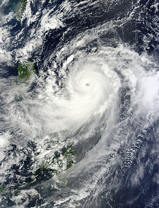
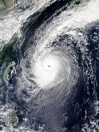
Typhoon Jelawat, known in the Philippines as Super Typhoon Lawin, was the most intense tropical cyclone of the 2012 Pacific typhoon season in terms of ten-minute maximum sustained winds, tied with Typhoon Sanba. Following Bolaven and Sanba, Jelawat was the third typhoon directly hitting Okinawa Island in 2012. Jelawat, which means carp in Malaysian, is a type of freshwater fish.
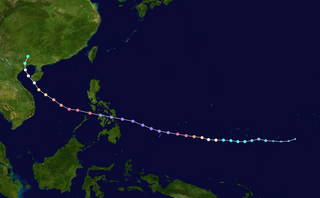
Typhoon Haiyan's meteorological history began with its origins as a tropical disturbance east-southeast of Pohnpei and lasted until its degeneration as a tropical cyclone over southern China. The thirteenth typhoon of the 2013 Pacific typhoon season, Haiyan originated from an area of low pressure several hundred kilometers east-southeast of Pohnpei in the Federated States of Micronesia on November 2. Tracking generally westward, environmental conditions favored tropical cyclogenesis and the system developed into a tropical depression the following day. After becoming a tropical storm and attaining the name Haiyan at 0000 UTC on November 4, the system began a period of rapid intensification that brought it to typhoon intensity by 1800 UTC on November 5. By November 6, the Joint Typhoon Warning Center (JTWC) assessed the system as a Category 5-equivalent super typhoon on the Saffir–Simpson hurricane wind scale; the storm passed over the island of Kayangel in Palau shortly after attaining this strength.
Typhoon Phanfone, known in the Philippines as Typhoon Neneng, was a powerful tropical cyclone which affected Japan in early October 2014. It was the eighteenth named storm and the eighth typhoon of the 2014 Pacific typhoon season. Phanfone started as a large area of convection well west of the International Date Line. The system was well organized and classified as Tropical Depression 18W on September 29. At the same day, it gained the name Phanfone due to very favorable conditions and intense thunderstorms rich with convection surrounding the storm's center. Phanfone would later go rapid intensification on October 1 due to warm sea-surface temperatures and very favorable environments. JTWC upgraded Phanfone to a Category 4 typhoon but weakened later back to Category 3 due to its eye replacing the old one and undergoing a minor eyewall replacement cycle.

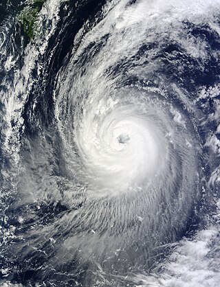
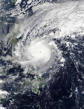
Typhoon Meranti, known in the Philippines as Super Typhoon Ferdie, was one of the most intense tropical cyclones on record. Impacting the Batanes in the Philippines, Taiwan, as well as Fujian Province in September 2016, Meranti formed as a tropical depression on September 8 near the island of Guam. Tracking to the west northwest, Meranti gradually intensified until September 11, at which point it began a period of rapid intensification. Continuing to rapidly intensify, it became a super typhoon early on September 12, as it passed through the Luzon Strait, ultimately reaching its peak intensity on September 13 with 1-minute sustained winds of 315 km/h (195 mph). Shortly afterwards, it passed directly over the island of Itbayat. Meranti passed to the south of Taiwan as a super typhoon, and began weakening steadily as a result of land interaction. By September 15, it struck Fujian Province as a Category 2-equivalent typhoon, becoming the strongest typhoon on record to impact the province. Upon moving inland, rapid weakening ensued and Meranti became extratropical the next day, dissipating shortly afterwards after it passed to the south of the Korean Peninsula.
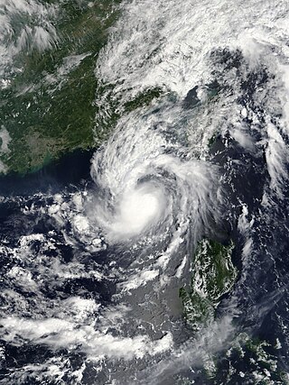
Typhoon Malakas, known in the Philippines as Typhoon Gener, was a powerful tropical cyclone which affected Taiwan and Japan in mid September 2016. It was the sixteenth named storm and the sixth typhoon of the annual typhoon season in 2016. Malakas formed on September 11, just south of Guam. The system gradually organized and improved its outer bands, which prompted JTWC to give its identifier as Tropical Depression 18W. A few hours later, JMA received its name Malakas for 18W. On September 13, Malakas entered the Philippine Area of Responsibility, which gained the name Gener by PAGASA. Despite its marginal conditions for further development, Malakas continued to intensify into a typhoon.
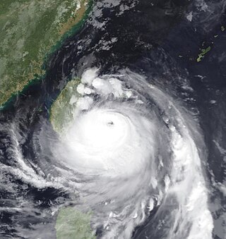
Typhoon Chaba, known in the Philippines as Super Typhoon Igme, was the fourth most intense tropical cyclone in 2016 and the strongest tropical cyclone to make landfall in South Korea since Sanba in 2012. Chaba also caused 7 deaths in the country. Typhoon Chaba was the eighteenth named storm and the eighth typhoon of the 2016 Pacific typhoon season. Chaba originated as a depression around the east-northeast of Guam. Being in a marginally favorable environment, JMA proceeds to name the system as Chaba. On September 28, JTWC gave its identifier as Tropical Depression 21W. Its LLCC starts to improve, prompting the JTWC to upgrade into a tropical storm. Chaba entered the Philippine Area of Responsibility, receiving the name Igme as it moved northwestwards. Chaba became more symmetrical which later ensued its rapid intensification.
Typhoon Nock-ten, known in the Philippines as Super Typhoon Nina, was the strongest Christmas Day tropical cyclone worldwide in terms of 1-minute sustained winds. Forming as a tropical depression southeast of Yap and strengthening into the twenty-sixth tropical storm of the annual typhoon season on December 21, 2016, Nock-ten intensified into the thirteenth typhoon of the season on December 23. Soon afterwards, the system underwent explosive intensification and became a Category 5-equivalent super typhoon early on December 25. Nock-ten weakened shortly afterwards before making eight landfalls over the Philippines. The typhoon weakened rapidly due to the landfalls as it entered the South China Sea on December 26, turned southwest, and ultimately dissipated on December 28 due to the winter monsoon.

Typhoon Noru was the second-longest-lasting tropical cyclone of the Northwest Pacific Ocean on record—behind only 1986's Wayne and tied with 1972's Rita—and the second-most-intense tropical cyclone of the basin in 2017, tied with Talim. Forming as the fifth named storm of the annual typhoon season on July 20, Noru further intensified into the first typhoon of the year on July 23. However, Noru began to interact with nearby Tropical Storm Kulap on July 24, executing a counterclockwise loop southeast of Japan. Weakening to a severe tropical storm on July 28, Noru began to restrengthen as it turned sharply to the west on July 30. Amid favorable conditions, Noru rapidly intensified into the season's first super typhoon, and reached peak intensity with annular characteristics on July 31. In early August, Noru underwent a gradual weakening trend while curving northwestwards and then northwards. After stalling off the Satsunan Islands weakening to a severe tropical storm again on August 5, the system began to accelerate northeastwards towards the Kansai region of Japan, making landfall in Wakayama Prefecture on August 7. Noru became extratropical over the Sea of Japan on August 8, and dissipated one day later.

The 2021 Pacific typhoon season was the second consecutive season to have below average tropical cyclone activity, with twenty-two named storms, and was the least active since 2011. Nine became typhoons, and five of those intensified into super typhoons. This low activity was caused by a strong La Niña that had persisted from the previous year. The season's first named storm, Dujuan, developed on February 16, while the last named storm, Rai, dissipated on December 21. The season's first typhoon, Surigae, reached typhoon status on April 16. It became the first super typhoon of the year on the next day, also becoming the strongest tropical cyclone in 2021. Surigae was also the most powerful tropical cyclone on record in the Northern Hemisphere for the month of April. Typhoons In-fa and Rai are responsible for more than half of the total damage this season, adding up to a combined total of $2.02 billion.

The 2022 Pacific typhoon season was the third consecutive season to have below average tropical cyclone activity, with twenty-five named storms forming. Of the tropical storms, ten became typhoons, and three would intensify into super typhoons. The season saw near-average activity by named storm count, although many of the storms were weak and short-lived, particularly towards the end of the season. This low activity was caused by an unusually strong La Niña that had persisted from 2020. The season's first named storm, Malakas, developed on April 6, while the last named storm, Pakhar, dissipated on December 12. The season's first typhoon, Malakas, reached typhoon status on April 12. The season ran throughout 2022, though most tropical cyclones typically develop between May and October. Tropical storms Megi and Nalgae were responsible for more than half of the casualties, while typhoons Hinnamnor and Nanmadol both caused $1 billion in damages.

Tropical Storm Son-Tinh, known in the Philippines as Tropical Storm Henry, was a weak but very deadly tropical cyclone that devastated Vietnam and Laos in July 2018. Son-Tinh originated from an area of low pressure over the Philippine Sea on July 15, 2018. Moving quickly westwards, Son-Tinh strengthened to the ninth tropical storm of the annual typhoon season on July 17. Intensifying only slightly while crossing the South China Sea, Son-Tinh made its first landfall over Hainan Island on July 18. After emerging into the Gulf of Tonkin, Son-Tinh restrengthened before making its second landfall as a tropical storm in Northern Vietnam on July 19. Once inland, Son-Tinh weakened into a low pressure area as it slowed and made a clockwise loop. The remnants of Son-Tinh then emerged back over water and regenerated into a tropical depression late on July 21.

Tropical Storm Sanba, known in the Philippines as Tropical Storm Basyang, was a weak tropical cyclone that affected southern and central parts of the Philippines in mid-February 2018. Sanba developed as a tropical depression in the open Pacific Ocean on February 8. The system moved generally westward while slowly developing, finally attaining tropical storm status on February 11. Soon after, wind shear caused the system to lose organization and remain as a minimal tropical storm through February 11 and 12. During this time, Sanba moved westwards then west-northwestwards, making landfall over northeastern Mindanao on February 13. The system weakened into a tropical depression before making another landfall in southeastern Negros later that day. After traversing the Philippine Islands, Sanba failed to reorganize significantly in the Sulu Sea and dissipated two days later west of Palawan.

The 2024 Pacific typhoon season was the fifth-latest starting Pacific typhoon season on record. It was average in terms of activity, and ended a four year streak of below average seasons that started in 2020. It was also the deadliest season since 2013, and became the fourth-costliest Pacific typhoon season on record, mostly due to Typhoon Yagi. This season saw an unusually active November, with the month seeing four simultaneously active named storms. The season runs throughout 2024, though most tropical cyclones typically develop between May and October. The season's first named storm, Ewiniar, developed on May 25, and eventually intensified into the first typhoon of the season, while the last named storm, Pabuk, dissipated on December 26. This season was an event in the annual cycle of tropical cyclone formation in the western Pacific Ocean.
Tropical Storm Barijat, known in the Philippines as Tropical Storm Neneng, was a weak tropical storm that caused flooding in the far northern regions of the Philippines and Southern China. Barijat, a replacement name for Utor which is a Marshallese word for coastal areas impacted by waves or winds, the thirty-third tropical depression and twenty-third tropical storm of the 2018 Pacific typhoon season, it was first noted as an area of convection in the South China Sea on September 6. On September 8, it was upgraded to a tropical depression, and by September 11, it intensified into a tropical storm, with the Japan Meteorological Agency (JMA) giving it the name Barijat. Barijat peaked in intensity 6 hours later, with 10-min winds of 40 knots and 1-min winds of 45 knots. Barijat continued westward, and on November 12 at 00:30 UTC, it made landfall over Zhanjiang, quickly dissipating afterwards.


