Tropical Storm Usagi (2018)

Last updated
Map key
  Tropical depression (≤38 mph, ≤62 km/h)
  Tropical storm (39–73 mph, 63–118 km/h)
  Category 1 (74–95 mph, 119–153 km/h)
  Category 2 (96–110 mph, 154–177 km/h)
  Category 3 (111–129 mph, 178–208 km/h)
  Category 4 (130–156 mph, 209–251 km/h)
  Category 5 (≥157 mph, ≥252 km/h)
  Unknown
Storm type
Disc Plain black.svg Tropical cyclone
Solid black.svg Subtropical cyclone
ArrowUp.svg Extratropical cyclone, remnant low, tropical disturbance, or monsoon depression

On November 3, the Central Pacific Hurricane Center began monitoring a disturbance that had formed in the Central Pacific basin. [1] Without further development on November 6, the disturbance moved out of the basin and into the West Pacific, [2] where the system was first monitored by the Joint Typhoon Warning Center (JTWC) at 22:00 UTC, assessing its potential of developing into a tropical cyclone within the next 24 hours as low. The system was within favorable conditions for development, with low vertical wind shear and sea surface temperatures reaching 28–30 °C (82–86 °F). [3] The system's tropical cyclone development potential within 24 hours was further upgraded to medium by the JTWC as its broad low-level circulation began to consolidate; however, atmospheric convection was disorganized. [4] On November 9, at 01:30 UTC, the JTWC issued a Tropical Cyclone Formation Alert (TCFA) for the system and upgraded the system's tropical cyclone development potential within 24 hours to high. [5] By the next day, however, the low-level circulation became almost fully exposed as wind shear of 15–25 knots (28–46 km/h; 17–29 mph) displaced the system's convection towards the east, prompting the JTWC to cancel the TCFA and downgrade the system's tropical cyclone development potential within 24 hours to medium. [6] On November 11, the JTWC further lowered the system's tropical cyclone development potential within 24 hours to low as the system's low-level circulation became fully exposed and ill-defined. [7]

On November 13, at 00:00 UTC, the Japan Meteorological Agency (JMA) assessed that the system had developed into a tropical depression near the Marshall Islands. [nb 1] Continuing westwards, [9] wind shear decreased, with the JTWC upgrading the system's tropical cyclone development potential within 24 hours to medium on November 14. [10] The PAGASA began monitoring the system, [11] and on November 17, at 12:00 UTC, the JTWC upgraded the system to a tropical depression, assigning it the designation 33W. [12] Despite dry air surrounding the system, convective activity continued alongside anticyclonic outflow. [13] On November 18, at 03:00 UTC, 33W entered the Philippine Area of Responsibility and was assigned the local name Samuel by the PAGASA. [11] Turning northwest, the system's low-level circulation was broad, [14] ill-defined, and elongated, [15] with wind shear at 25–30 knots (46–56 km/h; 29–35 mph) displacing convection over 100 nautical miles (190 km; 120 mi) to the west of the low-level circulation. [16] 33W made landfall on Hernani, Eastern Samar on November 20, at 17:00 UTC, [11] with the JTWC downgrading it to a disturbance an hour later [12] as the system's convection fragmented. [17] After turning west-southwestward, 33W made 4 more landfalls over Cebu, Negros Occidental, and Iloilo between 22:00 UTC and 02:00 UTC on the next day. Now in the Sulu Sea, [11] the system's low-level circulation moved closer to convection, [18] and on November 21, at 12:00 UTC, the JTWC upgraded 33W back to a tropical depression. [12] 33W made landfall on Araceli, Palawan at 13:00 UTC and moved into the South China Sea afterwards. [11]

On November 22, at 00:00 UTC, both the JMA and the JTWC upgraded 33W to a tropical storm as deep convection covered the system's low-level circulation, with the former assigning it the name Usagi. [9] [12] [19] Now in a favorable environment with low wind shear, the system's low-level circulation slowly consolidated and became better defined despite still being partially exposed. [20] Usagi exited the Philippine Area of Responsibility at 10:00 UTC; [11] it continued consolidating as rainbands wrapped into the system's center. [21] On November 23, an eye appeared on SSMIS microwave imagery, [22] and at 06:00 UTC, the JMA upgraded Usagi to a severe tropical storm. [9] The JTWC upgraded Usagi to a typhoon later that day. [12] On November 24, at 00:00 UTC, both the JMA and the JTWC estimated Usagi to have peaked, with the JMA estimating maximum 10-minute sustained winds of 110 kilometres per hour (70 mph) alongside a minimum central pressure of 990  hPa (29.23  inHg ) and the JTWC estimating maximum 1-minute sustained winds of 165 kilometres per hour (105 mph). [9] [12] An eye briefly appeared on satellite imagery before becoming filled with clouds. [23] Later in the day, a combination of land interaction and unfavorable environmental conditions caused Usagi to weaken [11] as its convective structure deteriorated. [24] Rainbands collapsed [25] as the system turned northwest, [11] and by November 25, both the JMA and the JTWC had downgraded Usagi to a tropical storm [9] [12] as central convection weakened. [26] Usagi made landfall on Vũng Tàu at 07:00 UTC, [11] with the JTWC downgrading Usagi to a tropical depression later that day. [12] During November 26, the JMA also downgraded Usagi to a tropical depression [9] as the JTWC further downgraded Usagi to a disturbance. [12] Usagi dissipated over Cambodia at 00:00 UTC on November 27. [9]

Preparations, impact, and aftermath

Cloudy skies in Can Tho on November 24 Can Tho (31171594047).jpg
Cloudy skies in Cần Thơ on November 24

Philippines

In preparation for the storm, the PAGASA raised signal #1 warnings in Visayas and Mindanao. [27] People were advised to not set sail east of Visayas and Mindanao as the storm moved closer. [28]

Flooding was reported in Iloilo City, with over 7,800 passengers being stranded throughout various ports throughout the country. [29] [30] 14 flights were also cancelled due to bad weather caused by the storm. [31] Usagi caused one death in the Philippines, [32] with agricultural damages being estimated at 52.2 million (US$992,000). 124,226 people were affected, 21,224 people were displaced, 4,967 people were evacuated, and 2,746 houses were damaged. [31] [33] Several landslides were reported during the storm's passage, all of which were in the island of Samar. [29] [31] Basco recorded a gust of 18 metres per second (65 km/h; 40 mph), with Cuyo recording 291.4 millimetres (11.47 in) of rain in 24 hours and 314 millimetres (12.4 in) of rain in total. [11]

₱6.9 million (US$132 thousand) was provided to assist those affected, with ₱3 million (US$56 thousand) being provided by the Department of Social Welfare and Development and the rest by other organizations. [33]

Severe Tropical Storm Usagi (Samuel)
Usagi 2018-11-24 0332Z.jpg
Severe Tropical Storm Usagi at peak intensity on November 24
Highest Tropical Cyclone Wind Signal Raised [11]
Signal No.Places Raised
1 Agusan del Norte, Agusan del Sur, Aklan, Antique, Biliran, Bohol, Camiguin, Capiz, Cebu, Dinagat Islands, Eastern Samar, Iloilo, Guimaras, Leyte, Masbate, Misamis Oriental, Negros Occidental, Negros Oriental, Northern Samar, southern Occidental Mindoro, southern Oriental Mindoro, Palawan, Romblon, Samar, Siquijor, Southern Leyte, Surigao del Norte, Surigao del Sur

Vietnam

88,787 people were mobilized to aid in the storm response, [34] with 1 thousand police officers and officials being prepared in Cần Giờ District. [35] Classes in Ho Chi Minh City were suspended on November 26, with Cần Giờ suspending classes until November 27. [36] 270 thousand students were affected after Khánh Hòa suspended classes. [37] A heavy rain warning was issued for the Central Highlands and the provinces between Bình Thuận and Thừa Thiên Huế. A flood warning was also issued for the Central Highlands, the Southeast, and the provinces between Quảng Trị and Bình Thuận. [38] A total of 160 thousand people were evacuated from several localities. [39]

Tân Bình District recorded 407.6 millimetres (16 in) of rain, surpassing the district's record of most rainfall. 60 roads were flooded in Ho Chi Minh City; [40] [41] three people were killed. [42] Rainfall totals in Ho Chi Minh City averaged 300–400 millimetres (12–16 in), with many buildings remaining partially flooded after Usagi's passage. [43] Flooding on some roads reached 1 metre (3.3 ft) deep. 14 fishermen were rescued; losses from damaged lobster, shrimp, and fish farms were estimated at 12 billion (US$516,000). [36] A 300 metres (980 ft) stretch of the North–South railway was washed away in Công Hải  [ vi ]. [44] 300 families on the island of Bình Lập were stranded after the bridge connecting the island to the mainland washed away. [45] 46 ships sunk as a result of the storm, [46] with 42 square kilometres (16 sq mi) of crops being flooded. [47] 51 houses were damaged, [48] with 160,000 thousand people being evacuated. [49] Losses in Vietnam were estimated at ₫925 billion (US$39.8 million). [50]

Following the passage of Usagi, local health departments were instructed to monitor water quality and sanitation by the Ministry of Health. [51]

See also

Notes

  1. The JMA is the official Regional Specialized Meteorological Centre for the northwestern Pacific Ocean. [8]

Related Research Articles

<span class="mw-page-title-main">2013 Pacific typhoon season</span> Typhoon season in the Western Pacific Ocean

The 2013 Pacific typhoon season was the most active Pacific typhoon season since 2004, and the deadliest since 1975. It featured Typhoon Haiyan, one of the most powerful storms and one of the strongest landfalling tropical cyclones in history. It was an above-average season with 31 named storms, 13 typhoons, and five super typhoons. The season's first named storm, Sonamu, developed on January 4 while the season's last named storm, Podul, dissipated on November 15. Despite the activity, most of the first seventeen named storms before mid-September were relatively weak, as only two of them reached typhoon intensity. Total damage amounted to at least $26.41 billion (USD), making it at the time the costliest Pacific typhoon season on record; it is currently the fourth costliest, behind the 2018, 2019 and 2023 seasons.

<span class="mw-page-title-main">2018 Pacific typhoon season</span> Typhoon season in the Western Pacific Ocean

The 2018 Pacific typhoon season was at the time, the costliest Pacific typhoon season on record, until the record was beaten by the following year. The season was well above-average, producing twenty-nine storms, thirteen typhoons, seven super typhoons and six Category 5 tropical cyclones. The season ran throughout 2018, though most tropical cyclones typically develop between May and October. The season's first named storm, Bolaven, developed on January 3, while the season's last named storm, Man-yi, dissipated on November 28. The season's first typhoon, Jelawat, reached typhoon status on March 29, and became the first super typhoon of the year on the next day.

<span class="mw-page-title-main">Typhoon Usagi (2013)</span> Pacific typhoon in 2013

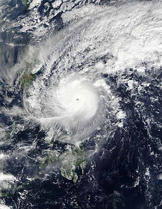
Typhoon Usagi, known in the Philippines as Super Typhoon Odette, was a violent tropical cyclone which affected Taiwan, the Philippines, China, and Hong Kong in September 2013. Usagi, or which means the constellation Lepus in Japanese, was the fourth typhoon and the nineteenth tropical storm in the basin. Developing into a tropical storm east of the Philippines late on September 16, Usagi began explosive intensification on September 19 and ultimately became a violent and large typhoon. Afterwards, the system weakened slowly, crossed the Bashi Channel on September 21, and made landfall over Guangdong, China on September 22.

<span class="mw-page-title-main">Timeline of the 2013 Pacific typhoon season</span>

Most of the tropical cyclones of the 2013 Pacific typhoon season formed between May and November of that year. The scope of this article is the Pacific Ocean north of the equator, between 100°E and the International Date Line. Tropical storms which form in the Western Pacific basin are assigned a name by the Japan Meteorological Agency (JMA). Tropical depressions forming in this basin are given a number with a "W" suffix by the United States' Joint Typhoon Warning Center (JTWC). The Philippine Atmospheric, Geophysical and Astronomical Services Administration (PAGASA) assigns names to tropical cyclones that enter or form in the Philippine area of responsibility, but these names are not in common use outside the Philippines.

<span class="mw-page-title-main">Timeline of the 2015 Pacific typhoon season</span>

This timeline documents all of the events of the 2015 Pacific typhoon season. Most of the tropical cyclones formed between May and November. The scope of this article is limited to the Pacific Ocean, north of the equator between 100°E and the International Date Line. This area, called the Western Pacific basin, is the responsibility of the Japanese Meteorological Agency (JMA). They host and operate the Regional Specialized Meteorological Center (RSMC), located in Tokyo. The Japanese Meteorological Agency (JMA) is also responsible for assigning names to all tropical storms that are formed within the basin. However, any storm that enters or forms in the Philippine Area of Responsibility (PAR) will be named by the Philippine Atmospheric, Geophysical and Astronomical Services Administration (PAGASA) using a local name. Also of note - the Western Pacific basin is monitored by the United States' Joint Typhoon Warning Center (JTWC), which gives all Tropical depressions a number with a "W" suffix.

<span class="mw-page-title-main">Tropical Storm Kujira (2015)</span> 2015 Pacific tropical storm

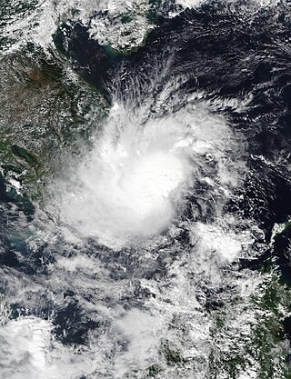
Tropical Storm Kujira was a tropical cyclone that prompted the PAGASA to declare the beginning of the rainy season in the Philippines. The ninth tropical depression, 8th named storm, and first storm to make landfall on China in the 2015 Pacific typhoon season, it formed as a tropical depression south of the Paracel Islands on June 19.

<span class="mw-page-title-main">Typhoon Haima</span> Pacific typhoon in 2016

Typhoon Haima, known in the Philippines as Super Typhoon Lawin, was the third most intense tropical cyclone worldwide in 2016. It was the twenty-second named storm and the eleventh typhoon of the annual typhoon season. Impacting the Philippines less than 3 days after Typhoon Sarika, Haima formed out of a tropical disturbance southwest of Chuuk on October 14, it developed into a tropical storm the next day. Steady strengthening occurred over the next day or two as it tracked westward towards the Philippines. After forming an eye shortly after it was upgraded to a typhoon, Haima began to rapidly strengthen and eventually became a super typhoon on October 18. It later attained its peak intensity as a Category 5-equivalent tropical cyclone before weakening slightly. Haima later made landfall in Peñablanca, Cagayan late on October 19 as a Category 4-equivalent storm. Rapid weakening occurred as it interacted with the landmasses until it entered the Southern China Sea as a weak typhoon. It formed a large ragged eye once again and remained steady in intensity until making landfall in China on October 21. It weakened below typhoon intensity and became extratropical on October 22. The cyclone drifted northeastwards and later eastwards before emerging over water again, but eventually dissipated by October 26.

<span class="mw-page-title-main">Typhoon Nock-ten</span> Pacific typhoon in 2016

Typhoon Nock-ten, known in the Philippines as Super Typhoon Nina, was the strongest Christmas Day tropical cyclone worldwide in terms of 1-minute sustained winds. Forming as a tropical depression southeast of Yap and strengthening into the twenty-sixth tropical storm of the annual typhoon season on December 21, 2016, Nock-ten intensified into the thirteenth typhoon of the season on December 23. Soon afterwards, the system underwent explosive intensification and became a Category 5-equivalent super typhoon early on December 25. Nock-ten weakened shortly afterwards before making eight landfalls over the Philippines. The typhoon weakened rapidly due to the landfalls as it entered the South China Sea on December 26, turned southwest, and ultimately dissipated on December 28 due to the winter monsoon.

<span class="mw-page-title-main">Typhoon Noru (2017)</span> Pacific typhoon in 2017

Typhoon Noru was the second-longest-lasting tropical cyclone of the Northwest Pacific Ocean on record—behind only 1986's Wayne and tied with 1972's Rita—and the second-most-intense tropical cyclone of the basin in 2017, tied with Talim. Forming as the fifth named storm of the annual typhoon season on July 20, Noru further intensified into the first typhoon of the year on July 23. However, Noru began to interact with nearby Tropical Storm Kulap on July 24, executing a counterclockwise loop southeast of Japan. Weakening to a severe tropical storm on July 28, Noru began to restrengthen as it turned sharply to the west on July 30. Amid favorable conditions, Noru rapidly intensified into the season's first super typhoon, and reached peak intensity with annular characteristics on July 31. In early August, Noru underwent a gradual weakening trend while curving northwestwards and then northwards. After stalling off the Satsunan Islands weakening to a severe tropical storm again on August 5, the system began to accelerate northeastwards towards the Kansai region of Japan, making landfall in Wakayama Prefecture on August 7. Noru became extratropical over the Sea of Japan on August 8, and dissipated one day later.

<span class="mw-page-title-main">Typhoon Nesat (2017)</span> Pacific typhoon in 2017

Typhoon Nesat, known in the Philippines as Typhoon Gorio, was a strong tropical cyclone that impacted Taiwan and Fujian, China. It was the ninth named storm and the second typhoon of the annual typhoon season. After consolidating slowly for several days, Tropical Storm Nesat developed east of the Philippines on July 25. While experiencing favorable environmental conditions such as very warm sea surface temperatures and low wind shear, Nesat strengthened into a typhoon and reached its peak intensity on July 28. On July 29, the typhoon made landfall near the Taiwanese city of Yilan, before weakening to a severe tropical storm and making landfall again near Fuqing on China's east coast late the same day. Moving into July 30, Nesat continued to weaken under the effects of land interaction.

<span class="mw-page-title-main">Typhoon Damrey (2017)</span> Pacific typhoon in 2017

Typhoon Damrey, known in the Philippines as Severe Tropical Storm Ramil, was a strong tropical cyclone that affected the Philippines and Vietnam during early November 2017. Damrey first originated as a tropical depression over the Philippine archipelago of Visayas on October 31. Emerging into the South China Sea a few days later, the system strengthened into the second deadliest and twenty-third named storm of the 2017 Pacific typhoon season. Rapidly intensifying, Damrey became the season's tenth typhoon on November 3, reaching its peak intensity as a Category 2 on the same day. Damrey made landfall over Khánh Hoà, Vietnam on November 4 and began to rapidly weaken, fully dissipating on November 5.

<span class="mw-page-title-main">Typhoon Tembin</span> Pacific typhoon in 2017

Typhoon Tembin, known in the Philippines as Typhoon Vinta, was the deadliest tropical cyclone to strike Mindanao since Typhoon Bopha in 2012. Following and impacting the Philippines less than a few days after the deadly Tropical Storm Kai-tak, Tembin, which means Libra in Japanese, the twenty-seventh named storm and the eleventh typhoon of the 2017 Pacific typhoon season. It was first classified as a weak tropical depression on December 16. The system gradually intensified and consolidated into a tropical storm on December 20. Tembin made landfall in Mindanao late the next day. On December 23, Tembin followed a path towards the South China Sea and intensified into a typhoon early the following day. Quick intensification ensued and Tembin reached its peak intensity as a low-end Category 2 typhoon as assessed by the Joint Typhoon Warning Center on December 24. Unfavorable conditions enhanced by the winter monsoon caused Tembin to rapidly weaken shortly afterwards, before it ultimately dissipated on December 26 while just south of Vietnam.

<span class="mw-page-title-main">2021 Pacific typhoon season</span> Typhoon season in the Western Pacific Ocean

The 2021 Pacific typhoon season was the second consecutive to have below average tropical cyclone activity, with twenty-two named storms, and was the least active since 2011. Nine became typhoons, and five of those intensified into super typhoons. This low activity was caused by a strong La Niña that had persisted from the previous year. The season's first named storm, Dujuan, developed on February 16, while the last named storm, Rai, dissipated on December 21. The season's first typhoon, Surigae, reached typhoon status on April 16. It became the first super typhoon of the year on the next day, also becoming the strongest tropical cyclone in 2021. Surigae was also the most powerful tropical cyclone on record in the Northern Hemisphere for the month of April. Typhoons In-fa and Rai are responsible for more than half of the total damage this season, adding up to a combined total of $2.02 billion.

<span class="mw-page-title-main">2022 Pacific typhoon season</span> Typhoon season in the Western Pacific Ocean

The 2022 Pacific typhoon season was the third consecutive season to have below average tropical cyclone activity, with twenty-five named storms forming. Of the tropical storms, ten became typhoons, and three would intensify into super typhoons. The season saw near-average activity by named storm count, although many of the storms were weak and short-lived, particularly towards the end of the season. This low activity was caused by an unusually strong La Niña that had persisted from 2020. The season's first named storm, Malakas, developed on April 6, while the last named storm, Pakhar, dissipated on December 12. The season's first typhoon, Malakas, reached typhoon status on April 12. The season ran throughout 2022, though most tropical cyclones typically develop between May and October. Tropical storms Megi and Nalgae were responsible for more than half of the casualties, while typhoons Hinnamnor and Nanmadol both caused $1 billion in damages.

<span class="mw-page-title-main">Tropical Storm Pabuk (2019)</span> Pacific tropical storm and North Indian cyclone in 2019

Tropical Storm Pabuk, also referred to as Cyclonic Storm Pabuk, was a weak storm that struck the Malay Peninsula in January 2019. It was also the earliest-forming storm in both the Northwestern Pacific Ocean and North Indian Ocean basins on record. Forming on the last day of 2018, Pabuk persisted into 2019, spanning two calendar years, and crossed into the North Indian Ocean basin several days later. The first tropical cyclone and named storm of the 2019 Pacific typhoon and North Indian Ocean cyclone seasons, Pabuk originated as a tropical disturbance in the South China Sea on December 28, 2018, which organized into a tropical depression on December 31. A day later, on January 1, 2019, the system intensified into a tropical storm and was named Pabuk. Pabuk made landfall in Thailand on January 4, emerging into the Bay of Bengal in the North Indian Ocean basin shortly afterward. Pabuk weakened after it entered the North Indian Ocean, eventually degenerating into a remnant low on January 7, before dissipating on the next day.

<span class="mw-page-title-main">Tropical Storm Yagi (2018)</span> Pacific tropical storm in 2018

Tropical Storm Yagi, known in the Philippines as Tropical Storm Karding, was a moderate but damaging tropical cyclone that impacted the Philippines from enhanced southwest monsoon and China. The fourteen named storm of the 2018 Pacific typhoon season. Yagi started its lifetime as an area of low-pressure, located southwest of Iwo To on August 1. The system struggled to intensify for five days until it was recognized as a depression by the JMA on August 7. JTWC later followed suit and went ahead to designate it as Tropical Depression 18W. It maintained its intensity due to easterly wind shear, despite the system being well organized. Both agencies upgraded into a tropical storm on the next day after showing winds of 35 knots.

<span class="mw-page-title-main">Tropical Storm Toraji (2018)</span> Pacific tropical storm in 2018

Tropical Storm Toraji was a weak, short-lived system that impacted Vietnam in November 2018. Forming as the twenty-seventh named storm of the 2018 Pacific typhoon season, Toraji developed as a tropical depression to the southeast of Vietnam on November 16. Quickly organising, the system strengthened into a tropical storm the next day. Toraji rapidly weakened thereafter early on November 18, when the storm made landfall over southeastern Vietnam, later dissipating. The storm's remnants moved into the Gulf of Thailand when Toraji re-organised back into a tropical depression on November 20. However Toraji quickly deteriorated on the same day as it moved closer to the Malay Peninsula.

<span class="mw-page-title-main">Typhoon Soulik (2018)</span> Pacific typhoon in 2018

Typhoon Soulik was an unusually large, and the deadliest typhoon to strike the Korean Peninsula since Khanun in 2012. Soulik formed from an area of low pressure on August 15, and was the twenty-ninth tropical depression, twentieth tropical storm, tenth severe tropical storm, and sixth typhoon of the 2018 Pacific typhoon season.

<span class="mw-page-title-main">Typhoon Prapiroon (2018)</span> Pacific typhoon in 2018

Typhoon Prapiroon, known in the Philippines as Severe Tropical Storm Florita, was a Category 1 typhoon that worsened the floods in Japan and also caused impacts in neighboring South Korea. The storm formed from an area of low pressure near the Philippines and strengthened to a typhoon before entering the Sea of Japan. The seventh named storm and the first typhoon of the annual annual typhoon season. Prapiroon originated from a low-pressure area far off the coast of Northern Luzon on June 28. Tracking westwards, it rapidly upgraded into a tropical storm, receiving the name Prapiroon due to favorable conditions in the Philippine Sea on the next day.

<span class="mw-page-title-main">Tropical Storm Barijat</span> Pacific tropical storm in 2018

Tropical Storm Barijat, known in the Philippines as Tropical Storm Neneng, was a weak tropical storm that caused flooding in the far northern regions of the Philippines and Southern China. Barijat, a replacement name for Utor which is a Marshallese word for coastal areas impacted by waves or winds, the thirty-third tropical depression and twenty-third tropical storm of the 2018 Pacific typhoon season, it was first noted as an area of convection in the South China Sea on September 6. On September 8, it was upgraded to a tropical depression, and by September 11, it intensified into a tropical storm, with the Japan Meteorological Agency (JMA) giving it the name Barijat. Barijat peaked in intensity 6 hours later, with 10-min winds of 40 knots and 1-min winds of 45 knots. Barijat continued westward, and on November 12 at 00:30 UTC, it made landfall over Zhanjiang, quickly dissipating afterwards.
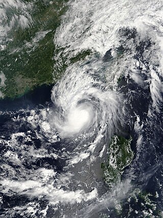
References

  1. Foster, Matthew (November 2, 2018). "Two-Day Graphical Tropical Weather Outlook". Central Pacific Hurricane Center . Honolulu, Hawaii. Archived from the original on November 24, 2018. Retrieved November 24, 2018.
  2. Kino, Genki (November 6, 2018). "Two-Day Graphical Tropical Weather Outlook". Central Pacific Hurricane Center . Honolulu, Hawaii. Archived from the original on November 24, 2018. Retrieved November 24, 2018.
  3. "Significant Tropical Weather Advisory for the Western and South Pacific Oceans Reissued from 062200Z-070600Z November 2018". Joint Typhoon Warning Center . November 6, 2018. Archived from the original on March 21, 2019. Retrieved July 9, 2021.
  4. "Significant Tropical Weather Advisory for the Western and South Pacific Oceans from 080600Z-090600Z November 2018". Joint Typhoon Warning Center . November 8, 2018. Archived from the original on March 21, 2019. Retrieved July 9, 2021.
  5. "Tropical Cyclone Formation Alert 090130". Joint Typhoon Warning Center . November 9, 2018. Archived from the original on November 13, 2018. Retrieved July 9, 2021.
  6. "Significant Tropical Weather Advisory for the Western and South Pacific Oceans from 100600Z-110600Z November 2018". Joint Typhoon Warning Center . November 10, 2018. Archived from the original on March 21, 2019. Retrieved July 9, 2021.
  7. "Significant Tropical Weather Advisory for the Western and South Pacific Oceans from 110600Z-120600Z November 2018". Joint Typhoon Warning Center . November 11, 2018. Archived from the original on March 21, 2019. Retrieved July 9, 2021.
  8. Annual Report on Activities of the RSMC Tokyo – Typhoon Center 2000 (PDF) (Report). Japan Meteorological Agency. July 2001. p. 3. Retrieved July 14, 2021.
  9. 1 2 3 4 5 6 7 Annual Report on the Activities of the RSMC Tokyo - Typhoon Center 2018 (PDF) (Report). Japan Meteorological Agency. December 26, 2019. Archived (PDF) from the original on February 15, 2020. Retrieved July 9, 2021.
  10. "Significant Tropical Weather Advisory for the Western and South Pacific Oceans Reissued from 142000Z-150600Z November 2018". Joint Typhoon Warning Center . November 14, 2018. Archived from the original on March 21, 2019. Retrieved July 9, 2021.
  11. 1 2 3 4 5 6 7 8 9 10 11 Duran, Samuel F.; Galang, Juanito S.; Gile, Robb P.; Reyes, Sheilla Mae R.; Tolentino, Jerome T. (June 2020). DOST-PAGASA Annual Report on Philippine Tropical Cyclones (PDF) (Report). Quezon City, Philippines: PAGASA. ISSN   2672-3190 . Retrieved July 9, 2021.
  12. 1 2 3 4 5 6 7 8 9 "2018 Western North Pacific Best Track Data". Joint Typhoon Warning Center . Retrieved July 9, 2021.
  13. "RSMC Tropical Cyclone Prognostic Reasoning No. 2 for TD Located at 6.6N 135.5E". Japan Meteorological Agency . November 18, 2018. Archived from the original on November 13, 2018. Retrieved July 9, 2021.
  14. "Prognostic Reasoning for Tropical Depression 33W (Thirtythree) Warning NR 01". Joint Typhoon Warning Center . November 18, 2018. Archived from the original on November 18, 2018. Retrieved July 12, 2021.
  15. "Prognostic Reasoning for Tropical Depression 33W (Thirtythree) Warning NR 02". Joint Typhoon Warning Center . November 18, 2018. Archived from the original on November 18, 2018. Retrieved July 12, 2021.
  16. "Prognostic Reasoning for Tropical Depression 33W (Thirtythree) Warning NR 04". Joint Typhoon Warning Center . November 19, 2018. Archived from the original on November 19, 2018. Retrieved July 12, 2021.
  17. "Prognostic Reasoning for Tropical Depression 33W (Thirtythree) Warning NR 11". Joint Typhoon Warning Center . November 20, 2018. Archived from the original on November 21, 2018. Retrieved July 12, 2021.
  18. "Prognostic Reasoning for Tropical Depression 33W (Thirtythree) Warning NR 13". Joint Typhoon Warning Center . November 21, 2018. Archived from the original on November 21, 2018. Retrieved July 14, 2021.
  19. "Prognostic Reasoning for Tropical Depression 33W (Thirtythree) Warning NR 16". Joint Typhoon Warning Center . November 22, 2018. Archived from the original on November 22, 2018. Retrieved July 14, 2021.
  20. "Prognostic Reasoning for Tropical Depression 33W (Thirtythree) Warning NR 17". Joint Typhoon Warning Center . November 22, 2018. Archived from the original on November 22, 2018. Retrieved July 22, 2021.
  21. "Prognostic Reasoning for Tropical Storm 33W (Usagi) Warning NR 19". Joint Typhoon Warning Center . November 22, 2018. Archived from the original on November 20, 2018. Retrieved July 22, 2021.
  22. "RSMC Tropical Cyclone Prognostic Reasoning No.22 for STS 1829 Usagi (1829)". Japan Meteorological Agency . November 23, 2018. Archived from the original on November 13, 2018. Retrieved July 22, 2021.
  23. "Prognostic Reasoning for Typhoon 33W (Usagi) Warning NR 25". Joint Typhoon Warning Center . November 24, 2018. Archived from the original on November 20, 2018. Retrieved July 26, 2021.
  24. "Prognostic Reasoning for Typhoon 33W (Usagi) Warning NR 26". Joint Typhoon Warning Center . November 24, 2018. Archived from the original on November 20, 2018. Retrieved July 26, 2021.
  25. "Prognostic Reasoning for Typhoon 33W (Usagi) Warning NR 27". Joint Typhoon Warning Center . November 24, 2018. Archived from the original on November 20, 2018. Retrieved July 26, 2021.
  26. "Prognostic Reasoning for Tropical Storm 33W (Usagi) Warning NR 28". Joint Typhoon Warning Center . November 25, 2018. Archived from the original on November 20, 2018. Retrieved July 26, 2021.
  27. "Samuel, napanatili ang lakas bago ang inaasahang landfall". ABS-CBN News and Current Affairs (in Tagalog). November 20, 2018. Archived from the original on February 3, 2020. Retrieved February 22, 2021.
  28. Mangosing, Frances (November 19, 2018). "Signal No. 1 raised as cyclone 'Samuel' nears Siargao area". Philippine Daily Inquirer . Retrieved January 6, 2022.
  29. 1 2 Ruedas, Jenette; Atienza, Kim (November 21, 2018). "Bagyong Samuel, nagdulot ng pagbaha sa Visayas". ABS-CBN News and Current Affairs (in Tagalog). Archived from the original on January 27, 2020. Retrieved February 22, 2021.
  30. "Over 7,800 stranded at seaports due to Tropical Depression Samuel". Rappler . Archived from the original on November 29, 2020. Retrieved February 22, 2021.
  31. 1 2 3 "Situational Report No.11 for Preparedness Measures and Effects of TD SAMUEL" (PDF). National Disaster Risk Reduction and Management Council. November 24, 2018. Archived (PDF) from the original on October 31, 2020. Retrieved November 25, 2018.
  32. Amazona, Roel (November 22, 2018). "1 dead, thousands displaced as 'Samuel' cuts through Samar". Philippine News Agency . Archived from the original on November 22, 2018. Retrieved November 22, 2018.
  33. 1 2 DSWD DROMIC Terminal Report on Tropical Depression "Samuel" (Report). Department of Social Welfare and Development Disaster Response Operations Monitoring and Information Center. January 22, 2019. Archived from the original on January 2, 2022. Retrieved July 27, 2021.
  34. "Lực lượng Hải quân tập trung giúp dân ứng phó bão số 9". Báo Tài nguyên và Môi trường (in Vietnamese). Ministry of Natural Resources and Environment. November 25, 2018. Archived from the original on July 27, 2021. Retrieved July 27, 2021.
  35. "HCM City prepares for Storm No.9's fury". Việt Nam News . November 25, 2018. Archived from the original on November 24, 2020. Retrieved January 2, 2022.
  36. 1 2 "Bão số 9 đổ bộ đất liền Nam Bộ, suy yếu thành áp thấp nhiệt đới". Thể thao & Văn hóa  [ vi ] (in Vietnamese). November 26, 2018. Archived from the original on July 27, 2021. Retrieved July 27, 2021.
  37. Nguyen, Huu; Quy, Nguyen (November 22, 2018). "Storm Usagi moves south, Saigon under threat". VnExpress . Archived from the original on November 27, 2020. Retrieved January 2, 2022.
  38. "Bão số 9 tiếp tục mạnh lên giật cấp 12, biển động mạnh sóng cao 6 mét". Thể thao & Văn hóa  [ vi ] (in Vietnamese). November 23, 2018. Archived from the original on July 27, 2021. Retrieved July 27, 2021.
  39. "Asia and the Pacific: Weekly Regional Humanitarian Snapshot (20 - 26 November 2018)". United Nations Office for the Coordination of Humanitarian Affairs. November 26, 2018. Archived from the original on July 27, 2021. Retrieved January 2, 2022 via ReliefWeb.
  40. "Vì sao bão số 9 gây mưa lớn kỷ lục khiến Sài Gòn ngập khắp nơi?". VietNamNet (in Vietnamese). November 26, 2018. Archived from the original on July 27, 2021. Retrieved July 27, 2021.
  41. Nguyen, Huu (November 26, 2018). "Storm Usagi disrupts air traffic in Saigon". VnExpress . Archived from the original on July 31, 2021. Retrieved July 31, 2021.
  42. "TP HCM 3 người chết do ảnh hưởng bão số 9". Pháp luật Việt Nam  [ vi ]. November 27, 2018. Archived from the original on January 2, 2022. Retrieved July 9, 2021.
  43. "City repairs damage caused by Typhoon Usagi". Việt Nam News . November 27, 2018. Archived from the original on November 8, 2020. Retrieved January 2, 2022.
  44. "Thông tuyến đường sắt Bắc - Nam sau tàn phá của bão số 9". Voice of Vietnam (in Vietnamese). November 26, 2018. Archived from the original on July 27, 2021. Retrieved July 27, 2021.
  45. Nghia, Cong; Nguyen, Tri (November 27, 2018). "Usagi flooding wipes bridge out, trapping residents on island". VnExpress . Archived from the original on July 31, 2021. Retrieved July 31, 2021.
  46. "Hậu quả bão số 9 - Usagi". Radio Free Asia (in Vietnamese). November 26, 2018. Archived from the original on July 27, 2021. Retrieved July 27, 2021.
  47. "Ngập lụt đe dọa các tỉnh miền Trung". Người lao động  [ vi ] (in Vietnamese). November 27, 2018. Archived from the original on July 27, 2021. Retrieved July 27, 2021.
  48. "ECHO Daily Flash of 26 November 2018". Directorate-General for European Civil Protection and Humanitarian Aid Operations Emergency Response Coordination Centre. November 26, 2018. Archived from the original on July 27, 2021. Retrieved July 27, 2021.
  49. "Asia and the Pacific: Weekly Regional Humanitarian Snapshot (20 - 26 November 2018)". United Nations Office for the Coordination of Humanitarian Affairs . November 26, 2018. Archived from the original on July 27, 2021. Retrieved July 27, 2021 via ReliefWeb.
  50. "Tóm tắt các cơn bão trong năm 2018" (in Vietnamese). Government of Tuyen Quang province. January 5, 2019. Archived from the original on July 8, 2021. Retrieved January 20, 2019.
  51. "Health ministry calls for sanitation after storm". Việt Nam News . November 27, 2018. Archived from the original on January 2, 2022. Retrieved January 2, 2022.