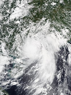
![]() Severe Tropical Storm Higos at peak intensity on August 19. | |
Meteorological history | |
---|---|
Formed | August 16,2020 |
Dissipated | August 20,2020 |
Severe tropical storm | |
10-minute sustained (JMA) | |
Highest winds | 100 km/h (65 mph) |
Lowest pressure | 992 hPa (mbar);29.29 inHg |
Tropical storm | |
1-minute sustained (SSHWS/JTWC) | |
Highest winds | 110 km/h (70 mph) |
Lowest pressure | 988 hPa (mbar);29.18 inHg |
Overall effects | |
Fatalities | 7 |
Damage | ≥$142 million (2020 USD) |
Areas affected | Mainland China,Taiwan,Vietnam,Hong Kong |
IBTrACS | |
Part of the 2020 Pacific typhoon season |
Severe Tropical Storm Higos,known in the Philippines as Tropical Depression Helen,was a tropical storm that affected China and Vietnam around the same area as Nuri two months prior. Higos formed from a tropical disturbance north of Luzon,the Philippines,on August 16. The storm tracked northeast and quickly intensified,becoming a tropical storm on August 17. The storm made landfall in Zhuhai,Guangdong at peak intensity on August 19,and quickly weakened soon after. Higos killed 7 people and caused 45 billion đồng (US$2 million) in damages in Vietnam. Higos also caused more than US$140 million in damages,but no fatalities in China. [1]
A new tropical depression formed from the Intertropical Convergence Zone east of Luzon on August 16. At 15:00 UTC, the PAGASA named the system Helen and began issuing severe weather bulletins for the tropical depression, but dropped the alerts as Helen left the Philippine area of responsibility after 4 hours. [2] [3] Around 21:00 UTC, JTWC issued the first Tropical Cyclone Formation Alert on the developing tropical depression. Early on the next day, JTWC followed suit from JMA and PAGASA by upgrading the system into Tropical Depression 08W. Shortly after, Helen intensified into a tropical storm and were given the name Higos by the JMA. Later in the day, the Joint Typhoon Warning Center also upgraded Higos into a tropical storm. JMA eventually upgraded the system to a severe tropical storm by evening that day. The Hong Kong Observatory and Macau Meteorological and Geophysical Bureau upgraded Higos into a marginal typhoon prior to landfall, with sustained hurricane-force winds in Macau indicating such an intensity. Higos made landfall over Zhuhai, Guangdong at peak intensity at around 06:00 CST on August 19 (22:00 UTC on August 18). [4] After landfall, Higos quickly weakened soon after and would dissipate in Guizhou, China on August 20.
In preparation for Higos, the Hong Kong Observatory raised the number 9 tropical cyclone warning signal in Hong Kong to warn of the possibility of hurricane-force winds. Winds generally reached gale to storm force over the southern part of Hong Kong under the influence of Higos' small circulation. [5] The Macao Meteorological and Geophysical Bureau issued the number 10 signal, the highest signal, at 05:00 am local time. [6] Over 65,000 people evacuated and schools were closed across these areas. Power was knocked out in Meizhou, after trees knocked down power lines. [7] Two campers who were unaware of the approaching storm had to be rescued from Tap Mun Island after arriving on August 14. [8] The storm also left 7 deaths and 45 billion đồng (US$2 million) in damages in Vietnam. [9]
The 2006 Pacific typhoon season was a destructive and deadly season, although it was near-average in terms of activity with a total of 23 named storms, 15 typhoons, and six super typhoons. Compared to the previous season, more typhoons inflicted damage across several countries, particularly China and the Philippines, some of which made landfall at higher intensities. The ratio of intense typhoons to all typhoons is at 0.73, the highest since 1970.
The 2007 Pacific typhoon season was a near average season which featured 24 named storms, fourteen typhoons, and five super typhoons. It was an event in the annual cycle of tropical cyclone formation, in which tropical cyclones form in the western Pacific Ocean. The season ran throughout 2007, though most tropical cyclones typically develop between May and November. The season's first named storm, Kong-rey, developed on March 30, while the season's last named storm, Mitag, dissipated on November 27. The season's first typhoon, Yutu, reached typhoon status on May 18, and became the first super typhoon of the year on the next day.
The 1980 Pacific typhoon season was a slightly-below average season when compared to the long-term average, though it featured several intense storms. It ran year-round in 1980, but most tropical cyclones formed between June and December. These dates conventionally delimit the period of each year when most tropical cyclones form in the northwestern Pacific Ocean. A total of 28 tropical depressions formed this year in the Western Pacific, of which 24 became tropical storms and were assigned a name by the Joint Typhoon Warning Center. Beginning in March, tropical cyclones formed in each subsequent month through December. Of the 24 named storms, 15 storms reached typhoon intensity, of which 2 reached super typhoon strength.
The 2008 Pacific typhoon season was a below average season which featured 22 named storms, eleven typhoons, and two super typhoons. The season had no official bounds; it ran year-round in 2008, but most tropical cyclones tend to form in the northwestern Pacific Ocean between May and November. These dates conventionally delimit the period of each year when most tropical cyclones form in the northwestern Pacific Ocean.
Severe Tropical Storm Kammuri, known in the Philippines as Tropical Storm Julian, was a weak but deadly tropical storm which impacted the Philippines, China, Vietnam, and Hong Kong in August 2008. The ninth named storm of the 2008 Pacific typhoon season, Kammuri developed as a tropical depression on August 4 north of Luzon. The next day, the depression intensified into a tropical storm, resulting in the Japan Meteorological Agency naming it Kammuri. The following day, Kammuri reached its peak intensity with sustained winds of 50 kn (93 km/h) before making landfall in Guangdong province, China. This would make Kammuri weaken into a tropical storm that evening, resulting in the JTWC issuing their last advisory on the system. Kammuri would later emerge in the Gulf of Tonkin the next day, making a second landfall over Guangxi province, China. After Kammuri made landfall, the JMA issued its final advisory on Kammuri.
Typhoon Pabuk, known in the Philippines as Tropical Storm Chedeng, was a minimal typhoon that formed on August 5, 2007. The system made landfall on Taiwan on August 7, and on August 9 Pabuk passed to the south of Hong Kong.
Typhoon Nuri, known in the Philippines as Typhoon Karen, was the 12th named storm and the seventh typhoon that was recognised by the Japan Meteorological Agency. The Joint Typhoon Warning Center recognised it as the 13th tropical depression, the 12th tropical storm and the 8th typhoon of the 2008 Pacific typhoon season. The name Nuri was submitted to the World Meteorological Organisation's Typhoon Committee by Malaysia in 2003 after the name Rusa was retired in 2002. The name Nuri is Malay for a blue crowned parroquet, a type of parrot. The name Karen was assigned by PAGASA to a tropical depression for the second time, the other time being in 2004 to Typhoon Rananim.
Typhoon Prapiroon, known in the Philippines as Tropical Storm Henry, was a minimal typhoon which caused deadly flooding in southern China in August 2006. Prapiroon developed out of a persistent area of convection accompanied by an area of low pressure on July 25 about 120 km (75 mi) west-southwest of Yap. Two days later, both the Japan Meteorological Agency (JMA) and PAGASA classified the system as a tropical depression, with PAGASA giving it the local name 'Henry'. By July 31, the Joint Typhoon Warning Center (JTWC) classified the system as Tropical Depression 07W. A strong subtropical ridge located to the north of the depression led to a west-northwest movement for most of the storm existence.
The 2017 Pacific typhoon season was a below-average season in terms of accumulated cyclone energy and the number of typhoons and super typhoons, and the first since the 1977 season to not produce a Category 5-equivalent typhoon on the Saffir–Simpson scale. The season produced a total of 27 named storms, 11 typhoons, and only two super typhoons, making it an average season in terms of storm numbers. It was an event in the annual cycle of tropical cyclone formation, in which tropical cyclones form in the western Pacific Ocean. The season runs throughout 2017, though most tropical cyclones typically develop between May and October. The season's first named storm, Muifa, developed on April 25, while the season's last named storm, Tembin, dissipated on December 26. This season also featured the latest occurrence of the first typhoon of the year since 1998, with Noru reaching this intensity on July 23.
The 2020 Pacific typhoon season was the first of a series of four below average Pacific typhoon seasons, and became the first with below-average tropical cyclone activity since 2014, with 23 named storms, 10 of which became typhoons and only 2 became super typhoons. This low activity was a consequence of La Niña that persisted from the summer of the year. It had the sixth-latest start in the basin on record, slightly behind 1973, and was the first to start that late since 2016. The first half of the season was unusually inactive, with only four systems, two named storms and one typhoon at the end of July. Additionally, the JTWC recorded no tropical cyclone development in the month of July, the first such occurrence since reliable records began. Despite that, this season featured Super Typhoon Goni, which made the strongest landfall worldwide in terms of 1-minute wind speed. The season's first named tropical cyclone, Vongfong, developed on May 8, while the season's last named tropical cyclone, Krovanh, dissipated on December 24. However, the season's last system was an unnamed tropical depression which dissipated on December 29.
This timeline documents all of the events of the 2015 Pacific typhoon season. Most of the tropical cyclones formed between May and November. The scope of this article is limited to the Pacific Ocean, north of the equator between 100°E and the International Date Line. This area, called the Western Pacific basin, is the responsibility of the Japanese Meteorological Agency (JMA). They host and operate the Regional Specialized Meteorological Center (RSMC), located in Tokyo. The Japanese Meteorological Agency (JMA) is also responsible for assigning names to all tropical storms that are formed within the basin. However, any storm that enters or forms in the Philippine Area of Responsibility (PAR) will be named by the Philippine Atmospheric, Geophysical and Astronomical Services Administration (PAGASA) using a local name. Also of note - the Western Pacific basin is monitored by the United States' Joint Typhoon Warning Center (JTWC), which gives all Tropical depressions a number with a "W" suffix.
Typhoon Haima, known in the Philippines as Super Typhoon Lawin, was the third most intense tropical cyclone worldwide in 2016. It was the twenty-second named storm and the eleventh typhoon of the annual typhoon season. Impacting the Philippines less than 3 days after Typhoon Sarika, Haima formed out of a tropical disturbance southwest of Chuuk on October 14, it developed into a tropical storm the next day. Steady strengthening occurred over the next day or two as it tracked westward towards the Philippines. After forming an eye shortly after it was upgraded to a typhoon, Haima began to rapidly strengthen and eventually became a super typhoon on October 18. It later attained its peak intensity as a Category 5-equivalent tropical cyclone before weakening slightly. Haima later made landfall in Peñablanca, Cagayan late on October 19 as a Category 4-equivalent storm. Rapid weakening occurred as it interacted with the landmasses until it entered the Southern China Sea as a weak typhoon. It formed a large ragged eye once again and remained steady in intensity until making landfall in China on October 21. It weakened below typhoon intensity and became extratropical on October 22. The cyclone drifted northeastwards and later eastwards before emerging over water again, but eventually dissipated by October 26.
Typhoon Hato, known in the Philippines as Severe Tropical Storm Isang, was a strong tropical cyclone that struck South China in August 2017. The thirteenth named storm and the fourth typhoon of the Pacific typhoon season, Hato formed as a tropical depression over the east of Luzon on 19 August. The system further developed and became a tropical storm the next day. On 21 August, Hato emerged over the northern portion of the South China Sea and reached typhoon intensity. Rapid intensification ensued on 23 August, and Hato became a Category 3-equivalent typhoon before making landfall over Jinwan, Zhuhai. The storm further weakened over land and dissipated on 24 August.
Severe Tropical Storm Pakhar, known in the Philippines as Tropical Storm Jolina, was a strong tropical storm that impacted the Philippines and South China during late August 2017. The storm followed Typhoon Hato which affected the same areas just a few days prior. Pakhar, the fourteenth named storm of the 2017 Pacific typhoon season, developed from a tropical depression to the east of Luzon during August 24 and intensified into a tropical storm later that day. Pakhar then made landfall in Aurora on August 25, before gradually intensifying and peaking as a severe tropical storm by August 27, making landfall over Taishan, Jiangmen in Guangdong Province.
The 2022 Pacific typhoon season was the third consecutive season to have below average tropical cyclone activity, with twenty-five named storms forming. Of the tropical storms, ten became typhoons, and three would intensify into super typhoons. The season saw near-average activity by named storm count, although many of the storms were weak and short-lived, particularly towards the end of the season. This low activity was caused by an unusually strong La Niña that had persisted from 2020. The season's first named storm, Malakas, developed on April 6, while the last named storm, Pakhar, dissipated on December 12. The season's first typhoon, Malakas, reached typhoon status on April 12. The season ran throughout 2022, though most tropical cyclones typically develop between May and October. Tropical storms Megi and Nalgae were responsible for more than half of the casualties, while typhoons Hinnamnor and Nanmadol both caused $1 billion in damages.
Typhoon Saudel, known in the Philippines as Typhoon Pepito, was a typhoon that affected the Philippines, Vietnam and Southern China in October 2020. It was seventeenth tropical storm and seventh typhoon of the 2020 Pacific typhoon season. The name Saudel was used for the first time, replacing Typhoon Soudelor in 2015, which caused serious damage in Taiwan and Mainland China. Saudel formed from a tropical disturbance east of the Philippines. The disturbance gradually organized and crossed the Philippines as a tropical storm. Once the system emerged into the South China Sea, it began to rapidly organize and intensify, becoming a typhoon early on October 22.
Tropical Storm Sarika, known in the Philippines as Tropical Storm Dodong, was a weak but costly tropical storm that affected Philippines and the East China in early-June 2011. The sixth tropical depression and the third named storm of the 2011 Pacific typhoon season, Sarika formed from an area of low pressure near Cebu City. As it traversed the Verde Island Passage on June 8, both the JTWC and the JMA started issuing advisories on the system, with the former issuing a TCFA on the system later that day. The next day, the PAGASA upgraded the low-pressure area to a tropical depression, naming it Dodong. Moving to the north, the system struggled to intensify due to strong wind shear and was downgraded by the JTWC to a tropical depression; however, the JMA kept the system as a minimal tropical storm until it made landfall near Shantou on June 11. It dissipated soon thereafter.
Severe Tropical Storm Kompasu, known in the Philippines as Severe Tropical Storm Maring was a very large and deadly tropical cyclone that affected the Philippines, Taiwan, and southeast China. Part of the 2021 Pacific typhoon season, Kompasu originated from an area of low pressure east of the Philippines on 6 October 2021. The Japan Meteorological Agency (JMA) classified it as a tropical depression that day. A day later, the Philippine Atmospheric, Geophysical and Astronomical Services Administration (PAGASA) classified it as a tropical depression, naming it Maring. The cyclone was initially heavily disorganised, competing with another vortex, Tropical Depression Nando. Eventually, Maring became dominant, and the JMA reclassified it as a tropical storm, naming it Kompasu. Kompasu made landfall in Cagayan, Philippines, on 11 October 2021, and two days later, the storm made landfall in Hainan, China. The cyclone dissipated on 14 October 2021 while located over Vietnam.
Severe Tropical Storm Nalgae, known in the Philippines as Severe Tropical Storm Paeng, was a very large and deadly tropical cyclone that wreaked havoc across the Philippines and later impacted Hong Kong and Macau. Nalgae, meaning wing in Korean, the twenty-second named storm of the 2022 Pacific typhoon season, Nalgae originated from an invest located east of the Philippines on October 26. The disturbance, initially designated as 93W, was eventually upgraded the following day to a tropical depression by the Joint Typhoon Warning Center (JTWC) and re-designated as 26W. The Japan Meteorological Agency (JMA) however, had already considered the disturbance as a tropical depression a day prior to JTWC's; the Philippine Atmospheric, Geophysical and Astronomical Services Administration (PAGASA) also followed the JMA's lead and gave it the name Paeng. That same day, it was upgraded again by the JMA to tropical storm status, thus gaining the name Nalgae.
Typhoon Saola, known in the Philippines as Super Typhoon Goring, was a powerful and erratic tropical cyclone that affected the Philippines, southern Taiwan, Hong Kong, Macau and South China. The name Saola, is in reference to a rare animal found in Vietnam. The ninth named storm, seventh typhoon, and third super typhoon of the 2023 typhoon season, Saola originated from an area of convection east of Taiwan and headed southwestwards.