The 2005 Pacific typhoon season was the least active typhoon season since 2000, producing 23 named storms, of which 13 became typhoons. It was an event in the annual cycle of tropical cyclone formation, in which tropical cyclones form in the western Pacific Ocean. The season ran throughout 2005, though most tropical cyclones typically develop between May and October. The season's first named storm, Kulap, developed on January 13, while the season's last named storm, Bolaven, dissipated on November 20. The season's first typhoon, Haitang, reached typhoon status on July 13, and became the first super typhoon of the year three days later.

The 2006 Pacific typhoon season was a near-average season which produced a total of 23 named storms, 15 typhoons, and six super typhoons. The season ran throughout 2006, though most tropical cyclones typically develop between May and October. The season's first named storm, Chanchu, developed on May 9, while the season's last named storm, Trami, dissipated on December 20.
This timeline documents all of the events of the 2005 Pacific typhoon season, the period that tropical cyclones formed in the Western Pacific Ocean during the year. The scope of this article is limited to the Pacific Ocean, north of the equator between 100°E and the International Date Line. Tropical depressions that form in the basin were given a number with a "W" suffix by the United States' Joint Typhoon Warning Center (JTWC). If a depression intensified into a tropical storm, it would be assigned a name by the Japan Meteorological Agency (JMA). In addition, the Philippine Atmospheric, Geophysical and Astronomical Services Administration (PAGASA) assigned names to tropical cyclones which were in their area of responsibility.

The 1986 Pacific typhoon season has no official bounds; it ran year-round in 1986, but most tropical cyclones tend to form in the northwestern Pacific Ocean between May and December. These dates conventionally delimit the period of each year when most tropical cyclones form in the northwestern Pacific Ocean. Tropical Storms formed in the entire west pacific basin were assigned a name by the Joint Typhoon Warning Center. Tropical depressions that enter or form in the Philippine area of responsibility are assigned a name by the Philippine Atmospheric, Geophysical and Astronomical Services Administration or PAGASA. This can often result in the same storm having two names.

The 2008 Pacific typhoon season was a below average season which featured 22 named storms, eleven typhoons, and two super typhoons. The season had no official bounds; it ran year-round in 2008, but most tropical cyclones tend to form in the northwestern Pacific Ocean between May and November. These dates conventionally delimit the period of each year when most tropical cyclones form in the northwestern Pacific Ocean.
The 2009 Pacific typhoon season was a below average season that spawned only 22 named storms, 13 typhoons, and five super typhoons. It was also recognized as the deadliest season in the Philippines for decades. The first half of the season was very quiet whereas the second half of the season was extremely active. The season's first named storm, Kujira, developed on May 3 while the season's last named storm, Nida, dissipated on December 3.
This timeline documents all of the events of the 2009 Pacific typhoon season which was the period that tropical cyclones formed in the Western Pacific Ocean during 2009, with most of the tropical cyclones forming between May and November. The scope of this article is limited to the Pacific Ocean, north of the equator between 100°E and the International Date Line. Tropical storms that form in the entire Western Pacific basin are assigned a name by the Japan Meteorological Agency. Tropical depressions that form in this basin are given a number with a "W" suffix by the United States' Joint Typhoon Warning Center. In addition, the Philippine Atmospheric, Geophysical and Astronomical Services Administration (PAGASA) assigns names to tropical cyclones that enter or form in the Philippine area of responsibility. These names, however, are not in common use outside of the Philippines.

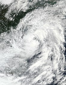
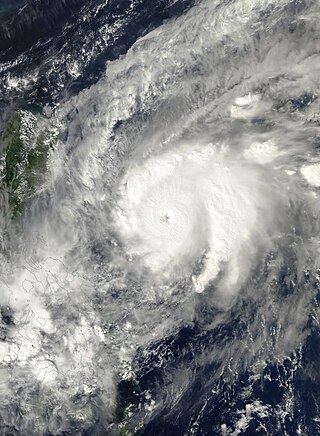
Tropical Storm Soudelor, known in the Philippines as Tropical Depression Gorio, was a weak tropical cyclone that lead to deadly flooding in the Philippines, China and Vietnam in July 2009. Forming out of an area of low pressure on July 9, Soudelor failed to maintain deep convection around its center for the duration of its existence. On July 10, the depression brushed the northern Philippines and intensified into a tropical storm on July 11. Later that day, the storm crossed the Leizhou Peninsula. The last public advisory from the JMA was issued the following day after Soudelor made landfall in southern China.
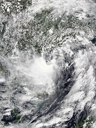
Tropical Storm Mujigae, known in the Philippines as Tropical Depression Maring was a tropical storm that affected the Philippines, China, Hong Kong, and Vietnam in September 2009. Mujigae originated from an area of convection that developed along with a monsoon trough with favorable conditions on 8 September. The disturbance organized to a tropical depression and was assigned the names 14W by the Joint Typhoon Warning Center and Maring by PAGASA later that day. Tropical Depression 14W would rapidly develop and attain tropical storm status by the JMA and be assigned the name Mujigae on 10 September. Mujigae soon encountered unfavorable conditions with wind shear and make landfall in Hainan Island on 11 September and Vietnam on 12 September before rapidly weakening and dissipating.

The 2013 Pacific typhoon season was the most active Pacific typhoon season since 2004, and the deadliest since 1975. It featured Typhoon Haiyan, one of the most powerful storms and one of the strongest landfalling tropical cyclones in history. It was an above-average season with 31 named storms, 13 typhoons, and five super typhoons. The season's first named storm, Sonamu, developed on January 4 while the season's last named storm, Podul, dissipated on November 15. Despite the activity, most of the first seventeen named storms before mid-September were relatively weak, as only two of them reached typhoon intensity. Total damage amounted to at least $26.41 billion (USD), making it at the time the costliest Pacific typhoon season on record; it is currently the third costliest, behind the 2018 and 2019 seasons.

The 2015 Pacific typhoon season was a slightly above average season that produced twenty-seven tropical storms, eighteen typhoons, and nine super typhoons. The season ran throughout 2015, though most tropical cyclones typically develop between May and November. The season's first named storm, Mekkhala, developed on January 15, while the season's last named storm, Melor, dissipated on December 17. The season saw at least one named tropical system forming in each of every month, the first time since 1965. Similar to the previous season, this season saw a high number of super typhoons. Accumulated cyclone energy (ACE) during 2015 was extremely high, the third highest since 1970, and the 2015 ACE has been attributed in part to anthropogenic warming.

The 2017 Pacific typhoon season was a below-average season in terms of accumulated cyclone energy and the number of typhoons and super typhoons, and the first since the 1977 season to not produce a Category 5-equivalent typhoon on the Saffir–Simpson scale. The season produced a total of 27 named storms, 11 typhoons, and only two super typhoons, making it an average season in terms of storm numbers. It was an event in the annual cycle of tropical cyclone formation, in which tropical cyclones form in the western Pacific Ocean. The season runs throughout 2017, though most tropical cyclones typically develop between May and October. The season's first named storm, Muifa, developed on April 25, while the season's last named storm, Tembin, dissipated on December 26. This season also featured the latest occurrence of the first typhoon of the year since 1998, with Noru reaching this intensity on July 23.

The 2020 Pacific typhoon season was the first of an ongoing series of below-average Pacific typhoon seasons, and became the first with below-average tropical cyclone activity since 2017, with 23 named storms, 10 of which became typhoons and only 2 became super typhoons. This low activity was a consequence of La Niña that persisted from the summer of the year. It had the fifth-latest start in the basin on record, slightly behind 1973, and was the first to start that late since 2016. The first half of the season was unusually inactive, with only four systems, two named storms and one typhoon at the end of July. Additionally, the JTWC recorded no tropical cyclone development in the month of July, the first such occurrence since reliable records began. The season's first named tropical cyclone, Vongfong, developed on May 8, while the season's last named tropical cyclone, Krovanh, dissipated on December 24. However, the season's last system was an unnamed tropical depression which dissipated on December 29.
Typhoon Chebi, known in the Philippines as Super Typhoon Queenie, was a powerful typhoon that impacted Luzon during November 2006. Chebi is the third typhoon since Typhoon Xangsane to hit the country destructively. The 30th tropical depression developed east of the Mariana Islands on October 31 as a weak disturbance. The system was dubbed into a tropical depression on November 8, until both the JMA and PAGASA upgraded it to a tropical storm on November 9. Chebi rapidly intensified to a Category 4 typhoon the next day and made landfall over northern Philippines on November 11. The system finally dissipated near Hong Kong and Vietnam on November 14.

Tropical Storm Kujira was a tropical cyclone that prompted the PAGASA to declare the beginning of the rainy season in the Philippines. The ninth tropical depression, 8th named storm, and first storm to make landfall on China in the 2015 Pacific typhoon season, it formed as a tropical depression south of the Paracel Islands on June 19.

Severe Tropical Storm Mirinae was a tropical cyclone of moderate intensity that struck Hainan Island, China and Northern Vietnam in late July 2016. The third named storm of the annual typhoon season, Mirinae formed on July 25, 2016 as a tropical depression west of Luzon, Philippines. On July 26, it moved west-northwestwards, and it had intensified into a tropical storm before making landfall on Hainan Island, China. After passing over Hainan, it intensified into a severe tropical storm and made landfall over the Red River Delta in Northern Vietnam late on July 27, and dissipated the next day.

Typhoon Saudel, known in the Philippines as Typhoon Pepito, was a typhoon that affected the Philippines, Vietnam and Southern China in October 2020. It was seventeenth tropical storm and seventh typhoon of the 2020 Pacific typhoon season. The name Saudel was used for the first time, replacing Typhoon Soudelor in 2015, which caused serious damage in Taiwan and Mainland China. Saudel formed from a tropical disturbance east of the Philippines. The disturbance gradually organized and crossed the Philippines as a tropical storm. Once the system emerged into the South China Sea, it began to rapidly organize and intensify, becoming a typhoon early on October 22.

Tropical Storm Linfa was a weak, short-lived but deadly and destructive tropical cyclone that was the twelfth wettest tropical cyclone on record and the second of nine tropical cyclones in a row to strike Vietnam in 2020, a little under a month after the less damaging Tropical Storm Noul. The fifteenth named storm of the 2020 Pacific typhoon season, Linfa originated from a tropical depression which formed just to the west of the Philippines on October 6. After passing through the island nation, the storm emerged into the South China Sea and slowly gained strength, earning the name Linfa on October 10 on approach to Vietnam. On the next day, Linfa had reached peak strength and made landfall in Vietnam, marking the beginning of a devastating series of floods in the country and worsening the already active monsoon season. Linfa quickly dissipated as it moved inland, but associated thunderstorms continued for several days.
Tropical Storm Koguma was a weak tropical cyclone that made landfall in Vietnam, causing minor damage. The fourth named storm of the 2021 Pacific typhoon season, the system was first noted as an area of persistent convection on the South China Sea on June 10, with the JTWC assessing the system in its first advisory as a monsoon depression. Tracking west-northwestward, marginally conductive environmental conditions in the area allowed slight intensification while drifting towards Hainan Island. On the next day, the JMA upgraded the system to a tropical depression as it passed to the south of the territory before the agency upgraded the system to a tropical storm on June 12, being assigned the name Koguma. The JTWC; however still treated the system as a tropical depression until 12:00 UTC that day. It continued to move northwest over the warm waters of the Gulf of Tonkin, eventually making landfall in Vietnam over Thanh Hóa by the end of the same day, rapidly weakening afterward.

Severe Tropical Storm Kompasu, known in the Philippines as Severe Tropical Storm Maring was a very large and deadly tropical cyclone that affected the Philippines, Taiwan, and southeast China. Part of the 2021 Pacific typhoon season, Kompasu originated from an area of low pressure east of the Philippines on 6 October 2021. The Japan Meteorological Agency (JMA) classified it as a tropical depression that day. A day later, the Philippine Atmospheric, Geophysical and Astronomical Services Administration (PAGASA) classified it as a tropical depression, naming it Maring. The cyclone was initially heavily disorganised, competing with another vortex, Tropical Depression Nando. Eventually, Maring became dominant, and the JMA reclassified it as a tropical storm, naming it Kompasu. Kompasu made landfall in Cagayan, Philippines, on 11 October 2021, and two days later, the storm made landfall in Hainan, China. The cyclone dissipated on 14 October 2021 while located over Vietnam.