Tropical Storm Talas (2017)

Last updated
Map key
  Tropical depression (≤38 mph, ≤62 km/h)
  Tropical storm (39–73 mph, 63–118 km/h)
  Category 1 (74–95 mph, 119–153 km/h)
  Category 2 (96–110 mph, 154–177 km/h)
  Category 3 (111–129 mph, 178–208 km/h)
  Category 4 (130–156 mph, 209–251 km/h)
  Category 5 (≥157 mph, ≥252 km/h)
  Unknown
Storm type
Disc Plain black.svg Tropical cyclone
Solid black.svg Subtropical cyclone
ArrowUp.svg Extratropical cyclone, remnant low, tropical disturbance, or monsoon depression

During July 13, the Joint Typhoon Warning Center (JTWC) began to monitor a tropical disturbance located about 648 km (403 mi) to the southeast of Hanoi, Vietnam. [2] By the next day, at around 06:00 UTC, the Japan Meteorological Agency (JMA) classified the system as a weak tropical depression, as it started to move slowly towards the northwest. [3] Six hours later, the JMA began issuing advisories, noting that the system was producing 10-minute sustained winds of at least 55 km/h (34 mph). [4] The JTWC issued a Tropical Cyclone Formation Alert at 02:30 UTC on July 15 after satellite imagery depicted deep convection wrapping into its developing low-level circulation center. [5] With the system continuing to develop, the JMA upgraded it to a tropical storm, assigning it the name Talas. [6] As convective banding improved, the JTWC upgraded the disturbance to a tropical depression by midday on July 15. [7] [8] Several hours later, the JTWC further upgraded Talas to a tropical storm after recording Dvorak estimates of T2.5, indicating 1-minute sustained winds of 65 km/h (40 mph). [9]

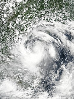
On July 16, Talas gradually intensified as it became better organized in response to being located in a favorable environment, consisting of low to moderate northeasterly vertical wind shear as well as good outflow to the south. [10] At 09:00 UTC, the JMA upgraded Talas into a severe tropical storm after the storm attained 10-minute sustained winds of 95 km/h (59 mph) and a minimum barometric pressure of 985 hPa (29.1 inHg); this constituted its peak intensity. [11] At the same time, the JTWC also recorded 1-minute sustained peak winds of 95 km/h (59 mph). [12] Shortly thereafter, Talas began to weaken due to land interaction and the JMA soon downgraded the system back to a tropical storm. [13] Around 18:00 UTC, Talas made landfall in Central Vietnam, near the city of Vinh. [14] Three hours later, the JTWC issued their final advisory on Talas as it continued to degrade while progressing inland. [15] The JMA soon followed suit with their final advisory at 09:00 UTC on July 17 while the weakening Talas was located over the northern portion of Laos. [16]

Preparations and impact

Vietnam

Talas made landfall near Vinh at around 18:00 UTC on July 16 as a moderate tropical storm. [14] According to the Central Steering Committee for Natural Disaster Prevention and Rescue, more than 2,700 homes were damaged in Nghe An Province. The Vietnam's National Center for Hydro-Meteorological Forecasting recorded wind gusts up to 100 km/h (62 mph) with wind damage being reported in Nghe An, Thanh Hóa and Ha Tinh provinces. [14] Over 400 mm (16 in) of rain fell in the central and northern parts of the country in the two days following up to landfall, while the capital, Hanoi, received 100 mm (3.9 in). [17] The storm sank a coal ship late on July 16; only three of the people on board were rescued while another ten remained missing. [18] In the Quảng Bình Province, fishing boats were washed ashore by waves as high as 5 m (16 ft); there, seven people were injured. [19] During July 17, flooded streets and disrupted train services stranded more than 4,000 passengers in the capital. Railway services from Hanoi to Vinh were canceled while trains from Hanoi to Saigon were delayed by five to seven hours. [19]

Overall, in Vietnam, the storm left 14 people dead and damaged around 2,700 houses. [20] About 50 boats sank. Around 50,000 ha (123,555 acres) of vegetable fields, [17] about 801 ha (1,980 acres) of aquaculture farms, and 47,632 ha (117,700 acres) of rice and subsidiary crops were damaged. [21] Damages in Nghe An were reported to reach up to 993 billion (US$43.7 million). [22] Total damage in Vietnam reached 1.6 trillion₫ (US$70.4 million). [23]

Hainan

During July 22, China's National Observatory issued a "blue alert" to Hainan province and the Beibu Gulf. About 22,901 fishing boats were moved while 39,425 people working at sea farms evacuated to Guangdong province. [24] Winds of 62–74 km/h (39–46 mph) were recorded over in some places, especially in areas around the Lingshui Li Autonomous County, as the storm neared the coast. [25] Southern portions of the province received rainfall of 3–6 in (8–15 cm). About 49 tourists were stranded from an island off the coast of Guandong. [26] Total economic losses in Hainan Province reached CNY 24 million (US$3.5 million). [27] In total, damage by Talas in China reached CNY 60 million (US$8.8 million). [28]

See also

Related Research Articles

<span class="mw-page-title-main">2012 Pacific typhoon season</span> Typhoon season in the Western Pacific Ocean

The 2012 Pacific typhoon season was a slightly above average season that produced 25 named storms, fourteen typhoons, and four intense typhoons. It was a destructive and the second consecutive year to be the deadliest season, primarily due to Typhoon Bopha which killed 1,901 people in the Philippines. It was an event in the annual cycle of tropical cyclone formation, in which tropical cyclones form in the western Pacific Ocean. The season ran throughout 2012, though most tropical cyclones typically develop between May and October. The season's first named storm, Pakhar, developed on March 28, while the season's last named storm, Wukong, dissipated on December 29. The season's first typhoon, Guchol, reached typhoon status on June 15, and became the first super typhoon of the year on June 17.

<span class="mw-page-title-main">2015 Pacific typhoon season</span> Typhoon season in the Western Pacific Ocean

The 2015 Pacific typhoon season was a slightly above average season that produced twenty-seven tropical storms, eighteen typhoons, and nine super typhoons. The season ran throughout 2015, though most tropical cyclones typically develop between May and November. The season's first named storm, Mekkhala, developed on January 15, while the season's last named storm, Melor, dissipated on December 17. The season saw at least one named tropical system forming in each of every month, the first time since 1965. Similar to the previous season, this season saw a high number of super typhoons. Accumulated cyclone energy (ACE) during 2015 was extremely high, the third highest since 1970, and the 2015 ACE has been attributed in part to anthropogenic warming.

<span class="mw-page-title-main">2017 Pacific typhoon season</span> Typhoon season in the Western Pacific Ocean

The 2017 Pacific typhoon season was a below-average season in terms of accumulated cyclone energy and the number of typhoons and super typhoons, and the first since the 1977 season to not produce a Category 5-equivalent typhoon on the Saffir–Simpson scale. The season produced a total of 27 named storms, 11 typhoons, and only two super typhoons, making it an average season in terms of storm numbers. It was an event in the annual cycle of tropical cyclone formation, in which tropical cyclones form in the western Pacific Ocean. The season runs throughout 2017, though most tropical cyclones typically develop between May and October. The season's first named storm, Muifa, developed on April 25, while the season's last named storm, Tembin, dissipated on December 26. This season also featured the latest occurrence of the first typhoon of the year since 1998, with Noru reaching this intensity on July 23.

<span class="mw-page-title-main">2018 Pacific typhoon season</span> Typhoon season in the Western Pacific Ocean

The 2018 Pacific typhoon season was at the time, the costliest Pacific typhoon season on record, until the record was beaten by the following year. The season was well above-average, producing twenty-nine storms, thirteen typhoons, seven super typhoons and six Category 5 tropical cyclones. The season ran throughout 2018, though most tropical cyclones typically develop between May and October. The season's first named storm, Bolaven, developed on January 3, while the season's last named storm, Man-yi, dissipated on November 28. The season's first typhoon, Jelawat, reached typhoon status on March 29, and became the first super typhoon of the year on the next day.

<span class="mw-page-title-main">2020 Pacific typhoon season</span> Typhoon season in the Western Pacific Ocean

The 2020 Pacific typhoon season was the first of an ongoing series of below-average Pacific typhoon seasons, and became the first with below-average tropical cyclone activity since 2014, with 23 named storms, 10 of which became typhoons and only 2 became super typhoons. This low activity was a consequence of La Niña that persisted from the summer of the year. It had the fifth-latest start in the basin on record, slightly behind 1973, and was the first to start that late since 2016. The first half of the season was unusually inactive, with only four systems, two named storms and one typhoon at the end of July. Additionally, the JTWC recorded no tropical cyclone development in the month of July, the first such occurrence since reliable records began. The season's first named tropical cyclone, Vongfong, developed on May 8, while the season's last named tropical cyclone, Krovanh, dissipated on December 24. However, the season's last system was an unnamed tropical depression which dissipated on December 29.

<span class="mw-page-title-main">Tropical Storm Rumbia (2013)</span> Pacific severe tropical storm in 2013

Severe Tropical Storm Rumbia, known in the Philippines as Tropical Storm Gorio, was a tropical cyclone that brought widespread flooding in areas of the Philippines and China late June and early July 2013. The sixth internationally named storm of the season, Rumbia formed from a broad area of low pressure situated in the southern Philippine Sea on June 27. Steadily organizing, the initial tropical depression moved towards the northwest as the result of a nearby subtropical ridge. On June 28, the disturbance strengthened to tropical storm strength, and subsequently made its first landfall on Eastern Samar in the Philippines early the following day. Rumbia spent roughly a day moving across the archipelago before emerging into the South China Sea. Over open waters, Rumbia resumed strengthening, and reached its peak intensity with winds of 95 km/h (50 mph) on July 1, ranking it as a severe tropical storm. The tropical cyclone weakened slightly before moving ashore the Leizhou Peninsula late that day. Due to land interaction, Rumbia quickly weakened into a low pressure area on July 2 and eventually dissipated soon afterwards.

<span class="mw-page-title-main">Timeline of the 2014 Pacific typhoon season</span>

This timeline documents all of the events of the 2014 Pacific typhoon season. Most of the tropical cyclones forming between May and November. The scope of this article is limited to the Pacific Ocean, north of the equator between 100°E and the International Date Line. Tropical storms that form in the entire Western Pacific basin are assigned a name by the Japan Meteorological Agency. Tropical depressions that form in this basin are given a number with a "W" suffix by the United States' Joint Typhoon Warning Center. In addition, the Philippine Atmospheric, Geophysical and Astronomical Services Administration (PAGASA) assigns names to tropical cyclones that enter or form in the Philippine area of responsibility. These names, however, are not in common use outside of the Philippines.

<span class="mw-page-title-main">Timeline of the 2012 Pacific typhoon season</span>

This timeline documents all of the events of the 2012 Pacific typhoon season. The scope of this article is limited to the Pacific Ocean, north of the equator between 100°E and the International Date Line. During the season, 34 systems were designated as tropical depressions by either the Japan Meteorological Agency (JMA), the Philippine Atmospheric, Geophysical and Astronomical Services Administration (PAGASA), the Joint Typhoon Warning Center (JTWC), or other National Meteorological and Hydrological Services such as the China Meteorological Administration and the Hong Kong Observatory. Since the JMA runs the Regional Specialized Meteorological Centre (RSMC) for the Western Pacific, they assigned names to tropical depressions which developed into tropical storms in the basin. PAGASA also assigned local names to systems which are active in their area of responsibility; however, these names are not in common use outside of the Philippines.

<span class="mw-page-title-main">Tropical Storm Mekkhala (2015)</span> Pacific typhoon in 2015

Severe Tropical Storm Mekkhala, known in the Philippines as Severe Tropical Storm Amang, was an early-season tropical cyclone that made landfall over the Philippines in January 2015. Mekkhala killed three people in the Bicol Region and caused light crop damage. Notably, the storm disturbed Pope Francis’ visit to the country after the victims of Typhoon Haiyan on November 8, 2013. Although the storm also caused an airplane crash in Tacloban, nobody was hurt in the incident.

<span class="mw-page-title-main">Typhoon Noul (2015)</span> Pacific typhoon in 2015

Typhoon Noul, known in the Philippines as Super Typhoon Dodong, was a relatively small but powerful tropical cyclone that affected several areas but caused minor damage. The sixth named storm and third typhoon of the annual typhoon season, Noul formed as a tropical depression over the eastern Caroline Islands on May 2, 2015. It moved generally to the west and west-northwest, gradually intensifying into a tropical storm and later typhoon. On May 9, Noul began rapid deepening as it developed a well-defined eye. Early the next day, the Japan Meteorological Agency (JMA) estimated peak 10 minute sustained winds of 205 km/h (125 mph), while the American-based Joint Typhoon Warning Center (JTWC) estimated peak 1 minute winds of 260 km/h (160 mph), equivalent to Category 5 on the Saffir–Simpson hurricane wind scale. Noul struck northeastern Luzon in the Philippines at that intensity and greatly weakened. After passing east of Taiwan, the typhoon accelerated to the northeast and weakened due to unfavorable conditions. On May 12, Noul became extratropical south of Japan, and the remnants continued to the northeast for several days, dissipating on May 16.

<span class="mw-page-title-main">Typhoon Melor</span> Pacific typhoon in 2015

Typhoon Melor, known in the Philippines as Typhoon Nona, was a powerful tropical cyclone that struck the Philippines in December 2015. The twenty-seventh named storm and the eighteenth typhoon of the annual typhoon season, Melor killed 51 people and caused ₱7.04 billion in damage.

<span class="mw-page-title-main">Typhoon Nock-ten</span> Pacific typhoon in 2016

Typhoon Nock-ten, known in the Philippines as Super Typhoon Nina, was the strongest Christmas Day tropical cyclone worldwide in terms of 1-minute sustained winds. Forming as a tropical depression southeast of Yap and strengthening into the twenty-sixth tropical storm of the annual typhoon season on December 21, 2016, Nock-ten intensified into the thirteenth typhoon of the season on December 23. Soon afterwards, the system underwent explosive intensification and became a Category 5-equivalent super typhoon early on December 25. Nock-ten weakened shortly afterwards before making eight landfalls over the Philippines. The typhoon weakened rapidly due to the landfalls as it entered the South China Sea on December 26, turned southwest, and ultimately dissipated on December 28 due to the winter monsoon.

<span class="mw-page-title-main">Typhoon Nesat (2017)</span> Pacific typhoon in 2017

Typhoon Nesat, known in the Philippines as Typhoon Gorio, was a strong tropical cyclone that impacted Taiwan and Fujian, China. It was the ninth named storm and the second typhoon of the annual typhoon season. After consolidating slowly for several days, Tropical Storm Nesat developed east of the Philippines on July 25. While experiencing favorable environmental conditions such as very warm sea surface temperatures and low wind shear, Nesat strengthened into a typhoon and reached its peak intensity on July 28. On July 29, the typhoon made landfall near the Taiwanese city of Yilan, before weakening to a severe tropical storm and making landfall again near Fuqing on China's east coast late the same day. Moving into July 30, Nesat continued to weaken under the effects of land interaction.

<span class="mw-page-title-main">Typhoon Damrey (2017)</span> Pacific typhoon in 2017

Typhoon Damrey, known in the Philippines as Severe Tropical Storm Ramil, was a strong tropical cyclone that affected the Philippines and Vietnam during early November 2017. Damrey first originated as a tropical depression over the Philippine archipelago of Visayas on October 31. Emerging into the South China Sea a few days later, the system strengthened into the second deadliest and twenty-third named storm of the 2017 Pacific typhoon season. Rapidly intensifying, Damrey became the season's tenth typhoon on November 3, reaching its peak intensity as a Category 2 on the same day. Damrey made landfall over Khánh Hoà, Vietnam on November 4 and began to rapidly weaken, fully dissipating on November 5.

<span class="mw-page-title-main">2021 Pacific typhoon season</span> Typhoon season in the Western Pacific Ocean

The 2021 Pacific typhoon season was the second consecutive to have below-average tropical cyclone activity, with twenty-two named storms, and was the least active since 2011. Nine became typhoons, and five of those intensified into super typhoons. This low activity was caused by a strong La Niña that had persisted from the previous year. The season's first named storm, Dujuan, developed on February 16, while the last named storm, Rai, dissipated on December 21. The season's first typhoon, Surigae, reached typhoon status on April 16. It became the first super typhoon of the year on the next day, also becoming the strongest tropical cyclone in 2021. Surigae was also the most powerful tropical cyclone on record in the Northern Hemisphere for the month of April. Typhoons In-fa and Rai are responsible for more than half of the total damage this season, adding up to a combined total of $2.02 billion.

<span class="mw-page-title-main">2022 Pacific typhoon season</span> Typhoon season in the Western Pacific Ocean

The 2022 Pacific typhoon season was the third consecutive season to have below-average tropical cyclone activity, with twenty-five named storms forming. Of the tropical storms, ten became typhoons, and three would intensify into super typhoons. The season saw a slightly below average activity by named storm count, although many of the storms were weak and short-lived, particularly towards the end of the season. This low activity was caused by an unusually strong La Niña that had persisted from 2020. The season's first named storm, Malakas, developed on April 6, while the last named storm, Pakhar, dissipated on December 12. The season's first typhoon, Malakas, reached typhoon status on April 12. The season ran throughout 2022, though most tropical cyclones typically develop between May and October. Tropical storms Megi and Nalgae were responsible for more than half of the casualties, while typhoons Hinnamnor and Nanmadol both caused $1 billion in damages.

<span class="mw-page-title-main">Tropical Storm Pabuk (2019)</span> Pacific tropical storm and North Indian cyclone in 2019

Tropical Storm Pabuk, also referred to as Cyclonic Storm Pabuk, was a weak storm that struck the Malay Peninsula in January 2019. It was also the earliest-forming storm in both the Northwestern Pacific Ocean and North Indian Ocean basins on record. Forming on the last day of 2018, Pabuk persisted into 2019, spanning two calendar years, and crossed into the North Indian Ocean basin several days later. The first tropical cyclone and named storm of the 2019 Pacific typhoon and North Indian Ocean cyclone seasons, Pabuk originated as a tropical disturbance in the South China Sea on December 28, 2018, which organized into a tropical depression on December 31. A day later, on January 1, 2019, the system intensified into a tropical storm and was named Pabuk. Pabuk made landfall in Thailand on January 4, emerging into the Bay of Bengal in the North Indian Ocean basin shortly afterward. Pabuk weakened after it entered the North Indian Ocean, eventually degenerating into a remnant low on January 7, before dissipating on the next day.

<span class="mw-page-title-main">Typhoon Soulik (2018)</span> Pacific typhoon in 2018

Typhoon Soulik was an unusually large, and the deadliest typhoon to strike the Korean Peninsula since Khanun in 2012. Soulik formed from an area of low pressure on August 15, and was the twenty-ninth tropical depression, twentieth tropical storm, tenth severe tropical storm, and sixth typhoon of the 2018 Pacific typhoon season.

<span class="mw-page-title-main">Tropical Storm Merbok (2017)</span> Pacific severe tropical storm in 2017

Severe Tropical Storm Merbok was a weak tropical cyclone that brought significant impacts to southern China in June 2017. Merbok developed out of a tropical depression which was first monitored by the JMA while it was west of Manila, Philippines, on June 10. The system would later be named 04W by the JTWC. The depression then strengthened into Tropical Storm Merbok before making landfall in eastern Shenzhen, China. Merbok would rapidly weaken inland, dissipating over Southern China on June 13.

<span class="mw-page-title-main">Tropical Storm Maliksi (2018)</span> West Pacific Tropical storm in 2018

Severe Tropical Storm Maliksi, known in the Philippines as Severe Tropical Storm Domeng, was a tropical cyclone in June 2018 that brought rainfall to the Philippines and Japan. It caused 2 deaths and prompted the PAGASA to declare the beginning of the rainy season in the Philippines. The fifth named storm and 4th tropical cyclone in the Philippine Area of Responsibility (PAR), it was first noted as an area of convection in the South of Palau on May 31.

References

  1. "TỔNG HỢP THIỆT HẠI DO THIÊN TAI NĂM 2017" (PDF). Retrieved 2024-03-21.
  2. "Unknown".[ permanent dead link ]
  3. "Unknown".[ permanent dead link ]
  4. "RSMC Tropical Cyclone Advisory TD". Japan Meteorological Agency. July 14, 2017. Archived from the original on July 16, 2017.
  5. "Unknown".[ permanent dead link ]
  6. "RSMC Tropical Cyclone Advisory TS 1704 TALAS (1704) UPGRADED FROM TD". Japan Meteorological Agency. July 15, 2017. Archived from the original on July 16, 2017.
  7. "Tropical Depression 06W (Talas) Warning Nr 001". Joint Typhoon Warning Center. July 15, 2017. Archived from the original on July 16, 2017.
  8. "Prognostic Reasoning for Tropical Depression 06W (Talas) Warning Nr 01". Joint Typhoon Warning Center. July 15, 2017. Archived from the original on July 16, 2017.
  9. "Prognostic Reasoning for Tropical Storm 06W (Talas) Warning Nr 02". Joint Typhoon Warning Center. July 15, 2017. Archived from the original on July 16, 2017.
  10. "Prognostic Reasoning for Tropical Storm 06W (Talas) Warning Nr 03". Joint Typhoon Warning Center. July 16, 2017. Archived from the original on July 16, 2017.
  11. "RSMC Tropical Cyclone Advisory STS 1704 TALAS (1704) UPGRADED FROM TS". Japan Meteorological Agency. July 16, 2017. Archived from the original on July 17, 2017.
  12. "Prognostic Reasoning for Tropical Storm 06W (Talas) Warning Nr 04". Joint Typhoon Warning Center. July 16, 2017. Archived from the original on July 16, 2017.
  13. "RSMC Tropical Cyclone Advisory TS 1704 TALAS (1704) DOWNGRADED FROM STS". Japan Meteorological Agency. July 16, 2017. Archived from the original on July 17, 2017.
  14. 1 2 3 "Tropical Storm Talas (06W)". Rish Management Solutions, Inc. July 17, 2017.
  15. "Tropical Storm 06W (Talas) Warning Nr 006". Joint Typhoon Warning Center. July 16, 2017. Archived from the original on July 17, 2017.
  16. "RSMC Tropical Cyclone Advisory TD 1704 TALAS (1704) DOWNGRADED FROM TS". Japan Meteorological Agency. July 17, 2017. Archived from the original on July 17, 2017.
  17. 1 2 "A tropical storm has left four dead, five missing in Vietnam". The China Post. July 19, 2017. Retrieved July 19, 2017.
  18. "Tropical Storm Talas hits Vietnam, leaves one dead". The Gulf Today. July 17, 2017. Archived from the original on July 17, 2017. Retrieved July 20, 2017.
  19. 1 2 "Storm Talas leaves path of destruction in Vietnam's central provinces". Nhân Dân. July 17, 2017.
  20. "Storm Talas kills 14 in Vietnam, destroys homes". The Straits Times. 19 July 2017. Retrieved 19 July 2017.
  21. "One more body found from missing ship". Viet Nam News. July 20, 2017.
  22. "Storm-ravaged Vietnamese province closes beaches with Sonca bearing down". VN Express. July 25, 2017.
  23. "Tổng cục Thống kê". www.gso.gov.vn.
  24. "Tropical Storm "Talas" makes landfall over central Vietnam". The Watchers. July 17, 2017.
  25. "Typhoon Talas to hit south China, 20,000 boats moored at bay". Xinhua. July 16, 2017. Archived from the original on July 15, 2017.
  26. "Stranded Tourists Rescued From China Island as Tropical Storm Talas Approaches". The Weather Channel. July 16, 2017.
  27. "海南部分地区遭受台风灾害". 中华人民共和国民政部. July 17, 2017. Archived from the original on December 4, 2017. Retrieved December 3, 2017.
  28. "MEMBER REPORT [China]" (PDF).
Severe Tropical Storm Talas
Talas 2017-07-16 0612Z.jpg
Severe Tropical Storm Talas near peak intensity and approaching Vietnam on July 16