Related Research Articles

Sai Kung District is one of the 18 districts of Hong Kong. The district comprises the southern half of the Sai Kung Peninsula, the Clear Water Bay Peninsula in the New Territories and a strip of land to the east of Kowloon. Areas in the district include Sai Kung Town, Hong Kong UNESCO Global Geopark, Tseung Kwan O and over 70 islands of different sizes. The administrative centre had been located in Sai Kung Town until the Sai Kung District Office was relocated to Tseung Kwan O recently. The district's population is concentrated in Tseung Kwan O, as of 2011. In 2011, the district was the third youngest district, with a median age of 39.3. Known as the "back garden of Hong Kong", Sai Kung has been able to retain its natural scenery. Many traditional customs and cultures are still retained in the rural villages.

Hoi Ha Wan or Jone's Cove is a bay at the north of Sai Kung Peninsula. It is part of Hoi Ha Wan Marine Park, a marine park in Hong Kong. The village of Hoi Ha is located on the innermost shore of Hoi Ha Wan.

The Sai Kung Peninsula is a peninsula in the easternmost part of the New Territories in Hong Kong. Its name comes from Sai Kung Town in the central southern area of the peninsula. The southern part of the peninsula is administered by Sai Kung District, the north by Tai Po District and the northwest by Sha Tin District.

The Ninepin Group or Kwo Chau Islands (果洲群島) is a group of 29 islands in the easternmost waters of Hong Kong. The Ninepin Group falls under the jurisdiction of Sai Kung District of Hong Kong.

Pak Tam Chung is an area in the southern part of the Sai Kung Peninsula in the New Territories of Hong Kong. It is administratively under the Sai Kung District.

High Island or Leung Shuen Wan Chau is a former island located in the southeast of Sai Kung Peninsula in Hong Kong, within Sai Kung District. Two sets of dams constructed between 1969 and 1979 and crossing the former Kwun Mun Channel (官門海峽), connect the island to the peninsula, thereby forming the High Island Reservoir. Before being connected to the mainland, the island had an area of 8.511 km² (3.29 square miles) and was the 4th largest island of Hong Kong in 1960.

Wan Tsai is a peninsula at the northern extremity of the north-western Sai Kung Peninsula, Hong Kong, with Hoi Ha Wan to its west and Long Harbour on its east. Grass Island lies east of the peninsula.

Clear Water Bay Road is a major road from Choi Hung Interchange in Ngau Chi Wan to Clear Water Bay, Sai Kung District. It also is a route to Sai Kung Town and Tseung Kwan O via Hiram's Highway and Hang Hau Road / Ying Yip Road respectively. An expressway deviation, New Clear Water Bay Road (新清水灣道), bypasses a steep, winding, 1 in 6 alignment of Clear Water Bay Road near Shun Lee and Fei Ngo Shan.

Sai Kung East Country Park is a country park on the Sai Kung Peninsula in Hong Kong, measuring 44.77 square kilometres (17.29 sq mi). It opened in 1978 and has features including:
Sai Kung West Country Park is a 30 square kilometres (12 sq mi) country park on the Sai Kung Peninsula in northeast Hong Kong.

Port Shelter, known in Cantonese as Ngau Mei Hoi, is a harbour south of Sai Kung Peninsula in Hong Kong. The water body connects to Inner Port Shelter, as well as Hebe Haven (白沙灣), Rocky Harbour (糧船灣海) and other water body. Outer Port Shelter, is situated at the mouth of the harbour.

Hebe Haven, also known as Pak Sha Wan, is a harbour on the south shore of Sai Kung Peninsula in Hong Kong.

Wong Shek Pier is a public pier on the shore of Long Harbour (赤徑海) in the north-east of Hong Kong's New Territories. It is situated in the Wong Shek (黃石) area of the Sai Kung Peninsula. Administratively it is in Tai Po District.
Sai Kung may refer to:
Cyclists in Hong Kong have the same rights and responsibilities as all other road users, except for prohibitions from expressways and some other designated locations, such as all tunnel areas, the Tsing Ma and Tsing Sha control areas, many elevated roads and many underpasses. At least one hand must be kept on the handlebars at all times. Cyclists must use a cycle track wherever one is present.

Sai Kung Country Park, a country park on the Sai Kung Peninsula in northeast Hong Kong, comprises:

Tsam Chuk Wan is a bay of the Sai Kung Peninsula in Hong Kong. By extension, it is also the name of the area around the bay. Tsam Chuk Wan Village (斬竹灣村) is one of the villages located within this area.
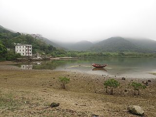
Chek Keng is an area and village of Sai Kung North in Hong Kong. It is administratively part of Tai Po District.
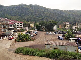
Tai Mong Tsai is a village and an area in Sai Kung District, Hong Kong.
Wong Chuk Wan is a village in Sai Kung District, Hong Kong.
References
22°28′03″N114°20′28″E / 22.4674°N 114.3412°E
| | This Hong Kong location article is a stub. You can help Wikipedia by expanding it. |