This article needs additional citations for verification .(March 2012) |
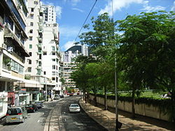
![]() Wong Nai Chung Road, the next station is HK Tram Happy Valley Station. A portion of Happy Valley Racecourse is visible on the right | |
Native name | 黃泥涌道 (Yue Chinese) |
---|---|
Length | 1.5 kilometres (0.93 mi) |
Location | Wan Chai, Hong Kong |
East end | Leighton Road / Matherson Street |
West end | Queen's Road East / Morrison Hill Road |
![]() |
Wong Nai Chung Road | |||||||||||
---|---|---|---|---|---|---|---|---|---|---|---|
Chinese | 黃泥涌道 | ||||||||||
Literal meaning | yellow mud gush road | ||||||||||
|
Wong Nai Chung Road is a major road in Happy Valley,Hong Kong. It is a U-shaped road that encircles the southern,western and eastern sides of the Happy Valley Racecourse.
Wong Nai Chung Road starts northeast at the junction with Leighton Road,then turns southward and meets Blue Pool Road at the southern residential area of the valley. It turns westward to Hong Kong Sanatorium &Hospital and then northwest to meet Morrison Hill Road and Queen's Road East and under the Wong Nai Chung Gap Flyover.
The western side of the road on the west of the valley forms part of the eastern limits of the City of Victoria. [1]
A circular branch line of Hong Kong Tramways runs along Wong Nai Chung Road,serving Happy Valley and the Happy Valley Racecourse. The Happy Valley Terminus is at the southernmost point of the road. The Tram runs on Wong Tai Chung Road in the section between Leighton Road station and Morrison Hill Road station.
Roads are listed from the East end to the West end.
An elevated Roadbridge,confusingly named Wong Nai Chung Gap Flyover,exists to link the Northern end of the Aberdeen Tunnel to the Canal Road Flyover.