
Kowloon is an urban area in Hong Kong comprising the Kowloon Peninsula and New Kowloon. It has a population of 2,019,533 and a population density of 43,033/km2 (111,450/sq mi) in 2006. It is one of the three areas of Hong Kong, along with Hong Kong Island and the New Territories. It is the smallest, second most populous and most densely populated of the divisions.

Kowloon City is an area in New Kowloon, Hong Kong. It is part of Kowloon City District.

Kwun Tong is an area in the Kwun Tong District of Hong Kong, situated at the eastern part of the Kowloon Peninsula, and its boundary stretches from Lion Rock in the north to Lei Yue Mun in the south, and from the winding paths of Kowloon Peak in the east to the north coast of the former Kai Tak Airport runway in the west.

The Kwun Tong line is a rapid transit line of the MTR network in Hong Kong, coloured green on the MTR map. Starting at Whampoa in Hung Hom and ending at Tiu Keng Leng in Tseung Kwan O, Sai Kung, the route has 17 stations and takes 35 minutes to complete. The Kwun Tong line is one of the busiest railway lines on the network connecting the central and the eastern portions of Kowloon via Wong Tai Sin. The line is mostly underground, but includes a lengthy elevated section, and runs generally in an east-west direction. During the morning rush hour, the Kwun Tong line utilises 33 trains running at 29tph to achieve a route capacity of 85,000 pphpd.
The Tseung Kwan O line is one of the ten lines of the MTR system in Hong Kong, indicated by the colour purple. It is currently 12.3 kilometres (7.6 mi) long, taking 15 minutes to travel throughout the entire line.

Tseung Kwan O New Town, commonly known as Tseung Kwan O, is one of the nine new towns in Hong Kong, built mainly on reclaimed land in the northern half of Junk Bay in southeastern New Territories, after which it is named.
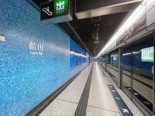
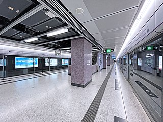
Lam Tin is a station on the Hong Kong MTR Kwun Tong line built as a part of the extension to Quarry Bay. The station is linked to the nearby hillside community of Lam Tin by a series of escalators.

Ngau Tau Kok is an area of eastern Kowloon in Hong Kong, in the north of Kwun Tong District east to Kowloon Bay. Largely residential, Ngau Tau Kok has a population in excess of 210,000.

Kwun Tong is one of the 18 districts of Hong Kong. It is located in Kowloon, and is the easternmost and southernmost district in Kowloon. It had a population of 666,500 in 2023. The district has the second highest population in Hong Kong, after Sha Tin District, while the income is below average. Kwun Tong District borders Sai Kung District to the east, Wong Tai Sin District to the north, and Kowloon City District to the west. To the south is Victoria Harbour, and the Eastern District directly across on Hong Kong Island.

Lam Tin is an area in the Kwun Tong District in southeastern New Kowloon, Hong Kong. Lam Tin is primarily a residential area but also hosts a major transport interchange and several shopping attractions. Lam Tin was once a large field in the vicinity of Kowloon Bay. During the Song dynasty, it was a site of salt production. Since the 1980s, a number of housing estates were constructed in Lam Tin.

Lei Yue Mun is a short channel in Hong Kong. It lies between Junk Bay and Victoria Harbour, separating Kowloon and Hong Kong Island. The channel is an important passage for the city, forming the eastern entrance of Victoria Harbour.

Yau Tong is an area of Hong Kong, located in the southeastern end of Kowloon, between Lei Yue Mun and Lam Tin, at the east shore of Victoria Harbour, west of Tseung Kwan O. Administratively, it is part of Kwun Tong District, the most densely populated district in Hong Kong.
Cha Kwo Ling is a hill in the eastern New Kowloon area of Hong Kong, and the area around it. It is adjacent to Victoria Harbour and located to the west of Yau Tong and southwest of Lam Tin. Administratively, it belongs to the Kwun Tong District. The northeastern entrance to the Eastern Harbour Crossing is located in this area.

Sceneway Garden is a private housing estate in Lam Tin, Hong Kong, built by Cheung Kong Holdings, and completed in 1992. Sceneway Garden is one of the few dog-friendly and pet-friendly private housing estates in Hong Kong, with a large open space for recreation that is suitable for exercising dogs.

Fortune City One is one of the two shopping centres of City One, Sha Tin, New Territories, Hong Kong. It is owned by Cheung Kong Holdings. It is connected to nearly apartments and another shopping centre in City One, Fortune City One Plus, just across the street, by bridges.
The following shows an overview of public housing estates, including those of the Home Ownership Scheme (HOS), Private Sector Participation Scheme (PSPS), and Tenant Purchase Scheme (TPS), in Lam Tin of Kwun Tong District, Kowloon, Hong Kong.

The Kai Tak Development, abbreviated as "KTD" and formerly called South East Kowloon Development (東南九龍發展計劃), refers to the redevelopment of the former Kai Tak Airport site in Kai Tak, Kowloon, Hong Kong.
Hong Ning Road Park is a public park between the districts of Ngau Tau Kok and Sau Mau Ping in Kowloon, Hong Kong. It is divided into two phases linked by a staircase. The park is distinct from the similarly-named Hong Ning Road Recreation Ground, which is located down the hill closer to Kwun Tong Town Centre.

Nord Anglia International School Hong Kong is an international school in Hong Kong. The international school opened in September 2014. As of 2017, it headed by Kenny Duncan. The school's curriculum consists of the International Baccalaureate, English National Curriculum and IGCSE.
