| Geography of Hong Kong |
|---|
| Water |
| Other Hong Kong topics |
| Hong Kong Portal |
The following is an incomplete list of urban settlements, towns, new towns (satellite towns) in Hong Kong .
While the Government of Hong Kong is unitary and Hong Kong law does not define cities and towns as subsidiary administrative units, the geographical limits of the City of Victoria , Kowloon and New Kowloon are defined in law. None of these three areas have administrative authorities separate from the Special Administrative Region. Administratively, Hong Kong is divided into districts, the boundaries of which are drawn according to mountains, coastlines and roads, and do not coincide with the natural extents of any urbanised areas.
| Settlement | Location |
|---|---|
| Victoria City | part of Central and Western, part of Wan Chai and part of Eastern |
| Kowloon including New Kowloon | Yau Tsim Mong, Sham Shui Po, Kowloon City, Wong Tai Sin and Kwun Tong |
| Cities | District | Year started developing |
|---|---|---|
| Tsuen Wan (Tsuen Wan, Kwai Chung and Tsing Yi) | Tsuen Wan and Kwai Tsing | 1950s |
| Sha Tin | Sha Tin | 1970s |
| Tuen Mun New Town | Tuen Mun | 1970s |
| Tai Po | Tai Po | early 1980s |
| Yuen Long | Yuen Long | early 1980s |
| Fanling-Sheung Shui | North | mid-1980s |
| Ma On Shan | Sha Tin | mid-1980s |
| Tseung Kwan O New Town | Sai Kung | late 1980s |
| Tin Shui Wai | Yuen Long | early 1990s |
| North Lantau (Tung Chung and Tai Ho) | Islands | 1994 |

Kowloon is an urban area in Hong Kong comprising the Kowloon Peninsula and New Kowloon. It has a population of 2,019,533 and a population density of 43,033/km2 (111,450/sq mi) in 2006. It is one of the three areas of Hong Kong, along with Hong Kong Island and the New Territories. It is the smallest, second most populous and most densely populated of the divisions.

The New Territories is one of the three areas of Hong Kong, alongside Hong Kong Island and the Kowloon Peninsula. It makes up 86.2% of Hong Kong's territory, and contains around half of the population of Hong Kong. Historically, it is the region described in the Convention for the Extension of Hong Kong Territory. According to that treaty, the territories comprise the mainland area north of Boundary Street on the Kowloon Peninsula and south of the Sham Chun River, as well as over 200 outlying islands, including Lantau Island, Lamma Island, Cheung Chau, and Peng Chau in the territory of Hong Kong.

Yuen Long District is one of the districts of Hong Kong. Located in the northwest of the New Territories, it had a population of 662,000 in 2021.

Sha Tin District is one of the 18 districts of Hong Kong. As one of the 9 districts located in the New Territories, it covers the areas of Sha Tin, Tai Wai, Ma On Shan, Fo Tan, Siu Lek Yuen, Kwun Yam Shan and Ma Liu Shui. The district is the most populous district in Hong Kong, with a population of 659,794 as per 2016 by-census, having a larger population than many states or dependencies including Iceland, Malta, Montenegro and Brunei.

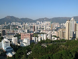
Kowloon Tong (Chinese: 九龍塘) is an area of Hong Kong located in Kowloon. The majority of the area is in the Kowloon City District. Its exact location is south of the Lion Rock, north of Boundary Street, east of the East Rail line and west of Grampian Road. It is one of the most expensive residential districts in Hong Kong.

The Light Rail, also known as the Light Rail Transit (LRT), officially the North-West Railway, is a light rail system in Hong Kong, serving the northwestern New Territories, within Tuen Mun District and Yuen Long District. The system operates over 1,435 mmstandard gauge track, using 750 V DC overhead power supply. It was once one of four systems comprising the KCR network in Hong Kong, before the MTR–KCR merger in 2007. It has a daily ridership of about 483,000 people. The line is colour warm yellow on the map, formerly deep orange before the MTR–KCR merger.

New Kowloon is an area in Hong Kong, bounded to the south by Boundary Street, and to the north by the ranges of the Eagle's Nest, Beacon Hill, Lion Rock, Tate's Cairn and Kowloon Peak. It covers the present-day Kwun Tong District and Wong Tai Sin District, and northern parts of the Sham Shui Po District and Kowloon City District.

Sheung Shui is an area in the New Territories, Hong Kong. Sheung Shui Town, a part of this area, is part of the Fanling–Sheung Shui New Town in the North District of Hong Kong. Fanling Town is to its southeast.

Ma Tau Wai is an area in the Kowloon City District, Kowloon, Hong Kong. It was originally a walled village between present-day Argyle Street and Prince Edward Road West, east of present-day St. Teresa's Hospital.

Sha Tin, also spelt Shatin, is a neighbourhood along Shing Mun River in the eastern New Territories, Hong Kong. Administratively, it is part of the Sha Tin District. Sha Tin is one of the neighbourhoods of the Sha Tin New Town project.
Castle Peak Road is the longest road in Hong Kong. Completed in 1920, it runs in the approximate shape of an arc of a semi-circle. It runs West from Tai Po Road in Sham Shui Po, New Kowloon, to Tuen Mun, then north to Yuen Long then east to Sheung Shui, in the very north of the New Territories. It is divided into 22 sections. It serves south, west and north New Territories, being one of the most distant roads in early Hong Kong.

Sham Shui Po District is one of 18 districts of Hong Kong. It is the second poorest district by income in Hong Kong, with a predominantly working-class population of 405,869 in 2016 and the lowest median household income of all districts. Sham Shui Po has long been home to poorer new immigrants from China. It also saw the birth of public housing in Hong Kong, as the government sought to resettle those displaced by a devastating fire in its slums. Sham Shui Po also hosted a Vietnamese refugee camp during the influx of migration in the aftermath of the Vietnam War in the 1970s.
Kowloon City District is one of the 18 districts of Hong Kong. It is located in the city of Kowloon and cut through by Boundary Street. It had a population of 381,352 in 2001, and increased to 418,732 in 2016. The district has the third most educated residents while its residents enjoy the highest income in Kowloon. It borders all the other districts in Kowloon, with Kwun Tong district to the east, Wong Tai Sin district to its northeast, Sham Shui Po district to its northwest, and Yau Tsim Mong district to its southwest.
Hang Hau is a residential area in Tseung Kwan O, Sai Kung, New Territories, Hong Kong. It is located at the eastern edge of the Tseung Kwan O New Town. Most of the land was reclaimed from Hang Hau Village and Shui Bin Village (水邊村).

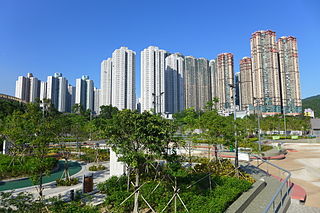
Tin Shui Wai New Town is a satellite town in the northwestern New Territories of Hong Kong. Originally a gei wai (基圍) fish pond area, it was developed in the 1980s as the second new town in Yuen Long District and the eighth in Hong Kong. It is 25 kilometres (16 mi) due northwest of Central, the main business area in the territory, on land reclaimed from low-lying areas south of Deep Bay, next to Ping Shan. The population was 292,000 in 2014, while the total projected population for when the town is fully built-out is about 306,000.
Articles related to Hong Kong include:

The Hong Kong government started developing new towns in the 1950s to accommodate Hong Kong's booming population. During the first phase of development, the newly developed towns were called "satellite towns", a concept borrowed from the United Kingdom, of which Hong Kong was a colony. Kwun Tong, located in eastern Kowloon, and Tsuen Wan, located in the south-west of the New Territories, were designated as the first satellite towns, when the urban area in Hong Kong was still relatively small, restricted to the central and western parts of Kowloon Peninsula and the northern side of Hong Kong Island. Wah Fu Estate was also built in a remote corner on the southern side of Hong Kong Island, with similar concepts but at a smaller scale.