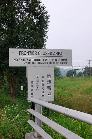
Sha Tau Kok is a closed town in Hong Kong. It is the last remaining major settlement in the Frontier Closed Area and is Hong Kong's northernmost town. Sha Tau Kok District is a rural committee district encompassing 46 villages within North District.[1]
Stone tools such as hammers,pounders,axes,and adzes dating to the Neolithic Period were excavated from San Tsuen,Sha Tau Kok,in 2001.[2][3] Pottery dating to the Han dynasty was also found there.[4]
17th–18th century
Not much is known about settlements in the area before the Qing dynasty (1644–1912). The provincial imperial government expressed interest in the Mirs Bay area because of its salt flats and pearl beds,in the 5th century and 8th century,respectively.[5]
The "Great Clearance" of the 17th century expelled most of the area's original settlers,who immigrated to locations such as present-day Yuen Long and Shenzhen. At the same time,the first Hakka settlers of Sha Tau Kok arrived to settle the northern shoreline of Mirs Bay,with more Hakka villages being established in the 18th century.[6]
19th century
The Sam Heung village alliance (Chinese:三鄉,lit. Alliance of Three Villages) occupied the original shoreline of Sha Tau Kok,which was called Tai Tan Tung (Chinese:大坦洞). The three villages included Shan Tsui,Tong To,and Tam Shui Hang.[7]
During the early 1800s,five wealthy villages–Shan Tsui,Tam Shui Hang,Wo Hang,Nam Chung,and Luk Keng–invested in the reclamation of Sha Tau Kok to provide more farmland for the growing population.[7]
Around the 1830s,leaders from 10 or so villages formed an alliance called the Shap Yeuk (Chinese:十約) to establish a new market at the newly reclaimed Sha Lan Ha,that would allow the Sha Tau Kok area to operate independently from older markets in Shenzhen.[5] The market was later named Tung Wo Market (Chinese:東和墟,lit. Eastern Peace Market) and described in 1848 by Basel missionary Theodore Hamberg as "a great market,quite given over to trade,newly built,and bustling with business".[8] In the 1850s there were approximately 50 shops.[9]
The name "Sha Tau Kok" first appeared in 1863,in the genealogy of the Ng (Chinese:吳) Clan of Sha Lan Ha (Chinese:沙欄吓). According to the Ngs,Sha Tau Kok was originally the name of the bay.[7] It was also used as a general name for the northwestern part of Mirs Bay in Volonteri's map of Sun On District in 1866.[10]
Tung Wo Market in 1898
As a result of the Convention for the Extension of Hong Kong Territory,Sha Tau Kok was leased to the British in 1898. Within the lease,Tung Wo Market was not included,leading to the problem of shopkeepers in Tung Wo being cut off from their ancestral villages in Hong Kong. On 19 April 1899,the elders of Shap Yeuk petitioned the district magistrate and begged that the lease not go forward,fearing excessive taxation and practical problems if they lived in British territory while their market was in Chinese territory.[11] This petition failed to change the lease,leading to a host of problems in the 20th century which led to the decline of Tung Wo Market.[12]
20th century
At the time of the 1911 government census,the population of Sha Tau Kok District was 8,570,while the population of Sha Tau Kok Village (British territory) was 14.[13][notes 1] The population was mostly Hakka,with a small minority of Punti and Hoklo. At the time,the present-day area of Sha Tau Kok Chuen and Yim Liu Ha was covered with marshes and salt fields. A sizable Hoklo population worked at those salt fields;they were the largest community of Hoklo speakers in the North District.[13]
The total population of Sha Tau Kok District was 8,357 in 1921,growing to 8,941 in 1931.[14][notes 2] During the 1920s,there were around a hundred shops in Tung Wo Market,with some moving across the border to San Lau Street.[15]
On 8 July 1967,amid the 1967 Hong Kong riots,several hundred demonstrators from the People's Republic of China (Mainland China),including members of the People's Militia,crossed the border at Sha Tau Kok and attacked the police post there. The police attempted to disperse the crowd using tear gas and wooden bullets. They then came under fire from several points,including automatic fire from Chinese territory,prompting an exchange of gunfire. Five police officers were killed and eleven were injured. Gunfire stopped with the arrival of a battalion from the British garrison.[16]
On 27 January 2005,it was announced that street maps would be put up to assist tourists.
In 2022,a pilot scheme was announced,under which limited areas of the town would be opened to tourists.[17] In July 2023,it was announced that the government was working on a feasibility study to redevelop the border control point between Sha Tau Kok and mainland China.[18]
As of 1January2024[update],a daily quota of 1,000 individual visitors (700 group visitors and 300 individual travellers) are permitted to visit Sha Tau Kok,as long as they have a Tourism Closed Area Permit. Individual travellers are only allowed to enter the area by public transport.[19] Although tourists can visit most parts of Sha Tau Kok,Chung Ying Street remains off limits.[20] Although some residents are supportive of the opening up,the move has also led to concern from some residents that tourists might affect[how?] the historically closed community.[21]
Geography
Cape of Sha Tau Kok sign
Located within the Mirs Bay area,Sha Tau Kok is located on the northern shoreline of Starling Inlet,10km northeast of Fanling. The town centre is by the sea and the northern part of the town encompasses the hill known as Yuen Tuen Shan (元墩山).
A section of Starling Inlet located offshore of Sha Tau Kok is one of the 26 designated marine fish culture zones in Hong Kong.[22]
Overview
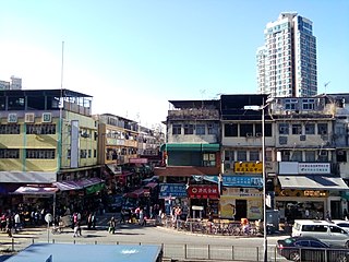
Sha Tau Kok on the Hong Kong side of the border is a small town located in the North District. The town has a post office,a bank and a few shops. Most of its residents are from Hakka-farming or Hoklo (Hokkien)-fishing backgrounds. As both farming and fishing have declined in the past few decades,better-educated younger people tend to move out and live and work in urban areas. Older villagers,however,remain,most of whom live in the Sha Tau Kok Chuen public housing estate or in other nearby villages.[23] Many working families return to visit at weekends during festivals or on holidays to attend ceremonies,such as the deity-thanking ceremony at Yim Liu Ha TsuenTin Hau Temple.[24]
Sha Tau Kok has the longest pier in Hong Kong,Sha Tau Kok Public Pier. Built in the 1960s and redeveloped in 2004,it spans 280 meters to reach the deeper waters of Starling Inlet,allowing larger vessels to berth at Sha Tau Kok.[24]
The main border crossing on Chung Ying StreetSha Tau Kok–Shatoujiao border wall from Sha Tau Kok, with buildings in Shatoujiao in the backgroundChung Ying Street, the famous street of Sha Tau Kok. The high rise buildings are located in Shatoujiao.
In Sha Tau Kok, the border between Hong Kong and mainland China runs along Chung Ying Street. Before the implementation of the "open door" policy in the 1980s, both sides exercised strict control over cross-boundary activities on the street. Even in the present day, non-residents must have a permit to visit Chung Ying Street.[26]
After the "open door" policy was put in place to allow freer travel between the two sides, mainland Chinese travelers flocked to Chung Ying Street to purchase goods unavailable in mainland China for personal use.[27][28] However, it simultaneously became a notorious point of goods trafficking, attracting businessmen and unemployed individuals looking to capitalize on the market opportunities created by the policy. Hawking and touting, smuggling, unlawful import and export of goods, and illegal employment became prominent on Chung Ying Street.[26]
Traffickers would enter Chung Ying Street with visitor permits, some making several trips a day acquiring goods and abusing the custom tariff limits on goods such as baby formula, soaps, electronics, and fabrics.[29] These traffickers would then unload their burden to collect their pay inside mainland Shatoujiao, or sell further inland in the mainland for greater profits.[30] Although there are a lot of goods leaving Hong Kong from Sha Tau Kok via Chung Ying Street, there is also an inflow of foodstuffs and other commodities that come through from China into Hong Kong throughout the day, only limited by the closure of the Chinese customs post.
A variety of items have been smuggled through the border. In 1996, 2,511 kilograms of raw uninspected meat was seized in a single case. In 1997, counterfeit trademarked clothes and imported garments without license valued at over $4.5 million were seized. Live chickens, pirated CDs, animal products of protected species as pangolins, owls, eagles and tigers have also been seized.[26] Attempted drugs trafficking is common to the present day, with cocaine, methamphetamine, and cannabis being intercepted at the Sha Tau Kok border.[31][32][33] Illegally imported pet animals such as cats and dogs, are also common.[34][35]
The control point of access to Shenzhen is located northwest of the hill in Shan Tsui (山咀). It is possible to travel into Shatoujiao on the China side, via the Sha Tau Kok border. A dedicated coach line, the Sha Tau Kok express (Chinese:沙頭角快線), runs at a regular schedule from Sheung Shui MTR station, Fan Ling MTR station, Kowloon Tong, and Yau Ma Tei. Travellers are taken through the Shek Chung Au (石涌凹) border checkpoint without a permit search, then head directly to the Sha Tau Kok Control Point.[36]
Here, passengers disembark, go through customs, and have their documents processed, before reboarding the coach to be driven to the mainland border immigration checkpoint. There, they disembark and take all their belongings through the mainland Chinese customs and again have their documents processed. Travellers from outside China are advised to obtain entry visas from the appropriate authorities, or via a travel agent before attempting the entry. Hong Kong residents of Chinese nationality should hold Home Return Permits (回鄉證) for entry into China.[37]
Sha Tau Kok Chuen (Chinese:沙頭角邨) is a public housing estate within the Sha Tau Kok Closed Area[38] built to accommodate the residents affected by the clearance[when?] of the area.[39] It consists of 51 low-rise blocks completed in 1988, 1989 and 1991, and it is the public housing estate with the most number of blocks in Hong Kong.[40]
Education
Sha Tau Kok is in Primary One Admission (POA) School Net 83. Within the school net are two aided schools (operated independently but funded with government money): Fuk Tak Education Society Primary School and Sha Tau Kok Central Primary School. No government schools are in the net.[41]
Shan Tsui Public School (山咀公立學校) is in Sha Tau Kok. In 2013, 90% of the roughly 200 students were Hong Kong residents living in Shenzhen.[42]
Before there were roads to access Sha Tau Kok, a branch of the Kowloon–Canton Railway (KCR), Sha Tau Kok Railway, served as the town's main transport. Completed in 1912, this service had three stops, linking Fanling Station to Sha Tau Kok Station. It was built from the original narrow gauge of the KCR British Section, and later replaced by standard gauge. After Sha Tau Kok Road was completed, the Sha Tau Kok Railway and its terminus ceased operations on 1 April 1928.[43] The area formerly occupied by the terminus is still known colloquially as "train station terminus" (火車頭).[44]
Sha Tau Kok bus terminus
Currently, there are both Kowloon Motor Bus and minibus services in Sha Tau Kok. The town has a bus terminus served by the KMB route 78K service as well as the smaller sixteen-seater minibus or public light bus service route number 55K.[45][46] Both begin in Sheung Shui and pass through Luen Wo Hui before terminating at Sha Tau Kok. Travelers can also board the KMB route 277A from Lam Tin station to Sha Tau Kok.[47] Alternatively, visitors can also travel by taxi.[48] However, passengers will not be allowed to proceed through the Closed Area border checkpoint if they do not carry a valid permit. Police personnel will board the bus at the checkpoint to check the identification documents and the required Frontier Closed Area permit of each passenger. If passengers do not possess these documents, they will be asked to leave by police personnel.[48]
Notable people
Lee Hong Lim – Hong Kong First Division League footballer
Lee Wai Lim – Hong Kong First Division League footballer
↑ As defined by the area of Sha Tau Kok Police District
Related Research Articles
Hong Kong has a highly developed transport network, encompassing both public and private transport. Based on Hong Kong Government's Travel Characteristics Survey, over 90% of daily journeys are on public transport, the highest rate in the world. However, in 2014 the Transport Advisory Committee, which advises the Government on transportation issues, issued a report on the much-worsened congestion problem in Hong Kong and pointed at the excessive growth of private cars during the past 10–15 years.
The New Lantao Bus Company (1973) Limited, commonly known as New Lantao Bus or NLB, is a franchised bus company operating in Hong Kong. It mainly operates bus routes on Lantau Island.
Tung Chung, meaning "eastern stream", is an area on the northwestern coast of Lantau Island, Hong Kong. One of the most recent new towns, it was formerly a rural fishing village beside Tung Chung Bay, and along the delta and lower courses of Tung Chung River and Ma Wan Chung in the north-western coast of Lantau Island. The area was once an important defence stronghold against pirates and foreign military during the Ming and the Qing dynasties.
Tung Ping Chau is an island in Hong Kong, part of Hong Kong UNESCO Global Geopark. It is also known as Ping Chau (平洲). Tung is prepended to the name at times so as to avoid possible confusion with Peng Chau, another island in Hong Kong with an identically pronounced name in Cantonese. Administratively, the island is part of the Tai Po District in the New Territories.
Sha Tin, also spelt Shatin, is a neighbourhood along Shing Mun River in the eastern New Territories, Hong Kong. Administratively, it is part of the Sha Tin District. Sha Tin is one of the neighbourhoods of the Sha Tin New Town project.
Shatoujiao is a subdistrict of Yantian District, Shenzhen, Guangdong, located on the border of Shenzhen and Hong Kong, China. The population is mainly composed of migrant workers from all parts of China along with a small number of Russians. Shatoujiao is a port with cargo coming into and exiting Yantian. It has a road connecting to Luohu, with regular bus services to Shenzhen's main train terminus and through connections to Guangzhou. The subdistrict lies near a highway that links to Meixian and Chaozhou while the Shenzhen railway is also part of the transport links between Hong Kong and Beijing.
Ma Liu Shui is an area in Sha Tin District, in the New Territories, Hong Kong.
Tuen Mun or Castle Peak is an area near the mouth of Tuen Mun River and Castle Peak Bay in the New Territories, Hong Kong. It was one of the earliest settlements in what is now Hong Kong and can be dated to the Neolithic period. In the more recent past, it was home to many Tanka fishermen who gathered at Castle Peak Bay. Tuen Mun is now a modern, mainly residential area in the north-west New Territories. As of 2011, 487,546 residents live in Tuen Mun.
Chung Ying Street is a street on the border between Hong Kong and Shenzhen, within the border town of Sha Tau Kok and Shatoujiao (Shenzhen). One side of the street belongs to Hong Kong and the other belongs to mainland China.
The Frontier Closed Area, established by the Frontier Closed Area Order, 1951, and 1984 is a regulated border zone in Hong Kong that extended inwards from the border with Mainland China.
Ta Kwu Ling is an area in the North District, New Territories, Hong Kong, located northeast of Sheung Shui, close to the border with mainland China and south to Liantang Subdistrict in Shenzhen.
Sha Tau Kok Public Pier or Sha Tau Kok Pier (沙頭角碼頭) is a public pier in Sha Tau Kok, New Territories, Hong Kong. It is located at the easternmost land border between Hong Kong and Shenzhen, China, and lies to the west of the former Sha Tau Kok Public Pier.
Luk Keng is an area in the North District of Hong Kong.
Shek Wu Hui is a non-administrative subdivision (neighbourhood) and former indigenous market town located in Sheung Shui in the North District of Hong Kong. The place name can be found in the record that published in 1819.
Heung Yuen Wai Highway, also abbreviated as HYWH, is a controlled-access highway in North District, New Territories, Hong Kong. It diverges from Fanling Highway of Route 9 at Kau Lung Hang, crosses Sha Tau Kok Road and connects to Heung Yuen Wai Control Point, a border checkpoint between Hong Kong and China which opened for freight traffic on 26 August 2020.
Shek Chung Au is a village in the Sha Tau Kok area of North District of Hong Kong.
Tong To is a village in the Sha Tau Kok area of North District of Hong Kong.
1 2 HASE, P. H. “EASTERN PEACE: SHA TAU KOK MARKET IN 1925.” Journal of the Hong Kong Branch of the Royal Asiatic Society, vol. 33, 1993, pp. 147–202. JSTOR, http://www.jstor.org/stable/23890097. Accessed 8 Oct. 2024.
↑ "Jahresberichte der Easier Mission 1849", pp 141–143. Reprinted in: Hase, P. H. “SHA TAU KOK IN 1853.” Journal of the Hong Kong Branch of the Royal Asiatic Society, vol. 30, 1990, pp. 281–97. JSTOR, http://www.jstor.org/stable/23889758. Accessed 7 Oct. 2024.
↑ Basel Mission Archive, Document A-1,2 Nr. 44, "Half-Yearly report of the Missionary Rev. P. Winnes, from 1st January to 1st July, 1853." Reprinted in: Hase, P. H. “SHA TAU KOK IN 1853.” Journal of the Hong Kong Branch of the Royal Asiatic Society, vol. 30, 1990, pp. 281–97. JSTOR, http://www.jstor.org/stable/23889758. Accessed 7 Oct. 2024.
This page is based on this Wikipedia article Text is available under the CC BY-SA 4.0 license; additional terms may apply. Images, videos and audio are available under their respective licenses.


 Sha Tau Kok Clinic along Sha Tau Kok Road – Shek Chung Au
 Sha Tau Kok Post Office
 Sha Tau Kok Post Office kiosk and post box
 Cape of Sha Tau Kok sign and tablet