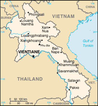
This is a list of cities in Laos , a country in Asia.

This is a list of cities in Laos , a country in Asia.
The 17th parallel north is a circle of latitude that is 17 degrees north of the Earth's equatorial plane. It crosses Africa, Asia, the Indian Ocean, the Pacific Ocean, Central America, the Caribbean, and the Atlantic Ocean.

The following properties are listed on the National Register of Historic Places in Brooklyn.

List of the National Register of Historic Places listings in Richmond County, New York.
This is intended to be a complete list of properties and districts listed on the National Register of Historic Places on Manhattan Island below 14th Street, which is a significant portion of the New York City borough of Manhattan. In turn, the borough of Manhattan is coterminous with New York County, New York. For properties and districts in other parts of Manhattan Island, the mainland neighborhood of Marble Hill, and the other islands of New York County, see National Register of Historic Places listings in Manhattan. The locations of National Register properties and districts may be seen in an online map by clicking on "Map of all coordinates".
This is intended to be a complete list of historic properties and districts listed on the National Register of Historic Places located on islands other than Manhattan Island but still in New York County, New York. For all properties and districts in the borough of Manhattan, see National Register of Historic Places listings in New York County, New York. The locations of National Register properties and districts may be seen in an online map by clicking on "Map of all coordinates".

There are over 9,300 Grade I listed buildings in England. This page is a list of the 111 of these buildings in the ceremonial county of the East Riding of Yorkshire. In the United Kingdom, the term listed building refers to a building or other structure officially designated as being of special architectural, historical or cultural significance; Grade I structures are those considered to be "buildings of exceptional interest". In England, the authority for listing under the Planning Act 1990 rests with Historic England, a non-departmental public body sponsored by the Department for Culture, Media and Sport.
National Register of Historic Places listings in the north and northwestern parts of the city of Baltimore, Maryland
National Register of Historic Places listings in the city of Baltimore, Maryland
National Register of Historic Places listings in the city of Baltimore, Maryland
This is a list of National Register of Historic Places properties and districts in downtown Baltimore, Maryland, United States. Many other properties are located in other parts of the city; for these, see National Register of Historic Places listings in Baltimore, Maryland.
![]() Media related to Cities in Laos at Wikimedia Commons
Media related to Cities in Laos at Wikimedia Commons