Related Research Articles
The Global 200 is the list of ecoregions identified by the World Wide Fund for Nature (WWF), the global conservation organization, as priorities for conservation. According to WWF, an ecoregion is defined as a "relatively large unit of land or water containing a characteristic set of natural communities that share a large majority of their species dynamics, and environmental conditions". For example, based on their levels of endemism, Madagascar gets multiple listings, ancient Lake Baikal gets one, and the North American Great Lakes get none.

The North Western Ghats moist deciduous forests is a tropical moist broadleaf forest ecoregion of southwestern India.

The South Western Ghats moist deciduous forests is an ecoregion in the Western Ghats of southern India with tropical and subtropical moist broadleaf forests. This biome covers the Nilgiri Hills between elevation of 250 and 1,000 m in Kerala, Karnataka and Tamil Nadu states.

The Annamite Range or the Annamese Mountains is a major mountain range of eastern Indochina, extending approximately 1,100 km (680 mi) through Laos, Vietnam, and a small area in northeast Cambodia. The mountain range is also referred to variously as Annamese Range, Annamese Mountains, Annamese Cordillera, Annamite Mountains and Annamite Cordillera. The name "Annam" is the Vietnamese pronunciation and terminology of Chinese: 安南, meaning "the tranquil south" referring to Vietnam. The French adopted the word and used "Annamese" or "Annamite" to refer to the Vietnamese.

The Northern Indochina subtropical forests are a subtropical moist broadleaf forest ecoregion of northern Indochina, covering portions of Vietnam, Laos, Thailand, Myanmar, and China's Yunnan Province.

The Southeastern Indochina dry evergreen forests are a tropical dry broadleaf forest ecoregion of Indochina.
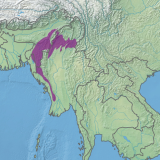
The Mizoram–Manipur–Kachin rain forests is a subtropical moist broadleaf forest ecoregion which occupies the lower hillsides of the mountainous border region joining India, Bangladesh, and Burma (Myanmar). The ecoregion covers an area of 135,600 square kilometres (52,400 sq mi). Located where the biotas of the Indian Subcontinent and Indochina meet, and in the transition between subtropical and tropical regions of Asia, the Mizoram–Manipur–Kachin rain forests are home to great biodiversity. The WWF rates the ecoregion as "Globally Outstanding" in biological distinctiveness.

The Cardamom Mountains rain forests is a tropical moist broadleaf forest ecoregion in Southeast Asia, as identified by the WWF. The ecoregion covers the Cardamom Mountains and Elephant Mountains and the adjacent coastal lowlands in eastern Thailand and southwestern Cambodia, as well as the Vietnamese island of Dao Phu Quoc.

The Puerto Rican moist forests are a tropical moist broadleaf forest ecoregion in Puerto Rico. They cover an area of 7,544 km2 (2,913 sq mi).

The Tenasserim–South Thailand semi-evergreen rain forests are a tropical moist forest ecoregion in Southeast Asia. The ecoregion extends north–south along the Kra Isthmus. It includes lowland forests along the coasts, and montane forests in the Tenasserim Hills and Bilauktaung range, which form the mountainous spine of the isthmus.

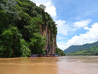
The Luang Prabang montane rain forests ecoregion covers elevations over 800 meters in the Luang Prabang mountains that straddle the border between northern Thailand and north-central Laos, and the highlands that stretch eastward across north-central Laos. While much of the forest cover has been degraded, there are still large areas of relatively untouched forest.
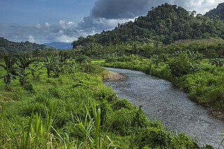
The Northern Annamites rain forests ecoregion covers the rugged and relatively unexplored northern Annamite Mountains of central Laos and Vietnam. There are high numbers of endemic plant species, and the relative remoteness and isolation of the area supports many rare and endangered animals. Rainfall is somewhat less than the lowland rainforest of the lower elevations in Vietnam, and the temperatures slightly cooler due to the higher altitude.
The Southern Annamites montane rain forests ecoregion covers a region of high biodiversity in the central and southern mountains of the Annamite Range in Vietnam. Terrain ranges from wet lowland forest to evergreen hardwood and conifer montane rain forest. There is a short dry season centered on January–February, but fog and dew are common throughout the year and support a lush forest character.

The Northern Khorat Plateau moist deciduous forests ecoregion covers a small area on the border between northeastern Thailand and Laos, in the transition zone between the drier Khorat Plateau to the south and the wetter Annamite Range of mountains to the north. Much of the ecoregion has been converted to agriculture along the floodplain of the middle course of the Mekong River.
The Northern Thailand–Laos moist deciduous forests ecoregion follows the upper course of the Nan River in northern Thailand and the Mekong River in Laos. This area has the highest proportion of tree cover in Thailand, with many forests dominated by Teak. The river valleys have been under pressure from human use: agriculture, teak plantations, and hunting have reduce plant and animal presence.
The Eastern Java-Bali rain forests ecoregion covers the lowland areas of the eastern half of the island of Java, and the island of Bali, in Indonesia. This ecoregion is distinct from the Eastern Java-Bali montane rain forests, which exists at higher altitudes where mountain forest habitat dominates. Very little of the natural lowland rainforest remains in its pre-human settlement state.
References
- Wikramanayake, Eric; Eric Dinerstein; Colby J. Loucks; et al. (2002). Terrestrial Ecoregions of the Indo-Pacific: a Conservation Assessment. Washington, DC: Island Press

List of ecoregions in Asia | |
|---|---|
| Sovereign states |
|
| States with limited recognition | |
| Dependencies and other territories | |