Related Research Articles

The Nam Theun 2 Hydropower Project, or simply NT2, is a hydroelectric dam on the Nam Theun River in Laos. Commercial operation of the plant began in April 2010. The scheme diverts water from the Nam Theun, a tributary of the Mekong River, to the Xe Bang Fai River, enabling a generation capacity of 1,075 MW, from a 350 m (1,148 ft) difference in elevation between the reservoir and the power station.
Hin Namno National Park is in Boualapha District, Khammouane Province, Laos. The park borders Phong Nha-Kẻ Bàng National Park of Vietnam to the east and Nakai-Nam Theun National Park of Laos to the north. Hin Namno National Park was created by prime ministerial decree in January 2020. It is managed by the Ministry of Agriculture and Forestry (MAF).

Nam Theun, is a river in Laos, in Khammouane and Bolikhamsai Provinces. Together with its tributaries Nam One, Nam Noy, and Nam Theun it has total length of 138 km (86 mi) and drains an area of 2,800 km2 (1,100 sq mi). "Nam Theun" is also three options for large dams on the same river, called Nam Theun 1, Nam Theun 1-2 and Nam Theun 2. Nam Theun 2, which was considered the most economic of the three options, is in operation.
Nakai-Nam Theun National Park in Nakai District, Khammouane Province, Laos, is one of the last remaining wildernesses in Southeast Asia. Nakai-Nam Theun covers approximately 4,270 km2 of the Annamite Range and the adjacent Nakai Plateau in Khammouane and Bolikhamsai Provinces. It was designated a national park on 15 February 2019 by Prime Ministerial Decree No. 36, 15 February 2019. It is managed by the Ministry of Agriculture and Forestry (MAF). It is adjacent to the Vu Quang National Park of Vietnam.
The Phou Hin Poun National Biodiversity Conservation Area, formerly known as the Khammouane Limestone National Biodiversity Conservation Area, is one of 21 National Biodiversity Conservation Areas of the Lao People's Democratic Republic. Located in a limestone tower karst region of the Annamite Range in Khammouane Province, it is home to a number of rare or newly discovered species. National Biodiversity Conservation Areas are not protected by the government of Laos in any meaningful way; the budget for each is about $500. The human population of the NBCA is 29,603.
Dong Ampham National Biodiversity Conservation Area is an extensive protected area which covers a significant part of Attapeu Province and Sekong Province in the southeast corner of Laos on the border with Vietnam. It covers the northeastern part of Attapeu Province and southeastern part of Sekong Province.
The Xe Kaman is a river in southeastern Laos. It flows through the Dong Ampham National Biodiversity Conservation Area of Attapeu Province. The river is known to have populations of dolphins. The area is being destroyed by a dam being built on the river. The village of Ban Hin Dam lies on the river and is where boat trips are launched.

Attapeu is a province of Laos in the southeast of the country. It has five districts: Samakkixay, Xaysetha, Sanamxay, Sanxay, and Phouvong, covering an area of 10,320 square kilometres (3,980 sq mi) with a population of 127,285. Its capital city lies at Attapeu.

Bolikhamsai is a province of Laos. Pakxan, Thaphabat, Pakkading, Borikhane, Viengthong, and Khamkeut are its districts and Pakxan is its capital city. The province is the site of the Nam Theun 2 Dam, the country's largest hydroelectric project.

Houaphanh province is a province in eastern Laos. Its capital is Xam Neua.
Sekong is a province of Laos in the southeast of the country.
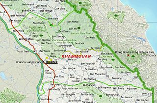
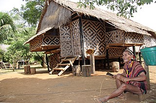
Khammouane province (Khammouan) is a province in the center of Laos. Its capital lies at Thakhek.

Salavan is a province of Laos, located in the south of the country. Its earlier name was Saravan which was changed by Thai to Salavan in 1828. It was part of the Champasak Kingdom in an area known as Muang Mang inhabited by minorities of Mon-Khmer groups.

Champasak is a province in southwestern Laos, near the borders with Thailand and Cambodia. It is one of the three principalities that succeeded the Lao kingdom of Lan Xang. As of the 2015 census, it had a population of 694,023. The capital is Pakse, but the province takes its name from Champasak, the former capital of the Kingdom of Champasak.

Protected areas in Laos include:
Nam Kading National Protected Area is a national protected area in Bolikhamsai Province in central Laos. This rugged and largely inaccessible park, cut through by its namesake Nam Kading river, is home to a wide variety of plant and animal species, some endangered. Due to its ruggedness, the park lacks any significant human settlement.
Phou Den Din National Protected Area or National Biodiversity Conservation Area (NBCA) is a protected area in northern Laos, covering 2,200 km2 in Phongsaly Province. It was designated a National Biodiversity Conservation Area in 1993. The name is also spelt Phou Dene Dinh and Phou Daen Din. The conservation area borders Vietnam, and its terrain is hilly, rising to over 2,000 meters. Among the animals found in the area are elephants, gibbons, macaques, gaurs, bantengs, Asiatic black bears, sun bears, leopards, and tigers. It also has a high density of lesser fish eagles and crested kingfishers. The area is not easily accessible, but can be reached by boat or on foot.

The Northern Annamites rain forests ecoregion covers the rugged and relatively unexplored northern Annamite Mountains of central Laos and Vietnam. There are high numbers of endemic plant species, and the relative remoteness and isolation of the area supports many rare and endangered animals. Rainfall is somewhat less than the lowland rainforest of the lower elevations in Vietnam, and the temperatures slightly cooler due to the higher elevation.
Vietic peoples refers to a group of ethnic groups of Southeast Asia.