Nam Kading National Protected Area

Last updated
Nam Kading National Protected Area
IUCN category VI (protected area with sustainable use of natural resources)
Laos adm location map.svg
Red pog.svg
Location in Laos
Location Bolikhamsai Province, Laos
Nearest city Paksan
Coordinates 18°24′28″N104°14′25″E / 18.40778°N 104.24028°E / 18.40778; 104.24028 Coordinates: 18°24′28″N104°14′25″E / 18.40778°N 104.24028°E / 18.40778; 104.24028
Area1,690 km2 (650 sq mi) (decreed), [1] 1,570–1,584 km2 (606–612 sq mi) (actual) [1] [2]
Designated29 October 1993 (1993-10-29)

Nam Kading National Protected Area is a national protected area in Bolikhamsai Province in central Laos. This rugged and largely inaccessible park, cut through by its namesake Nam Kading river, is home to a wide variety of plant and animal species, some endangered. Due to its ruggedness, the park lacks any significant human settlement. [1]

Contents

Geography

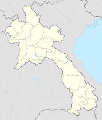
Nam Kading National Protected Area is located about 40 kilometres (25 mi) east of Paksan near the village of Pakkading and covers parts of Paksan, Pakkading, Borikhane and Khamkeut districts. The park's current area is about 1,600 square kilometres (620 sq mi). [1] [2] Elevations range from about 140 metres (460 ft) to the park's highest point, Phou Pa Paek at 1,514 metres (4,970 ft). [2]

The park's main river is the Nam Kading, flowing from south to north through the park. It is a significant tributary of the Mekong. The Nam Theun 2 Dam, Laos's largest hydroelectric project, impounds the Nam Kading south of the park in Khammouane Province. The courses of three other rivers, the Nam Muan, Nam Sat and Nam Tek, divide the park into four mountain ranges. [2]

History

Beginning in 1989, the area of the current park was surveyed by air and land. In 1993 Nam Kading National Biodiversity Conservation Area was decreed. Surveying began in 1995 to assess the impact on the park of two further proposed hydropower projects: Theun-Hinboun and Nam Theun 1. [1]

Flora and fauna

The park's main forest types are evergreen forest dry mixed deciduous forest. Native forests in Nam Kading cover 84% of the park area. A study for the proposed hydropower projects identified 256 plant species in the park. Included were two rare species: Lagerstroemia balansae and Justicia gendarussa . [2]

Rufous-necked hornbill Rufous Necked Hornbill 2.jpg
Rufous-necked hornbill

The native forests of Nam Kading host a large variety of animals and birds, including endangered species. At least 43 mammal species and 234 bird species have been catalogued. [2] Animal species include both northern and southern white-cheeked gibbon, sun bear, gaur, tiger, elephant and giant muntjac. [2] [3]

Endangered bird species include great hornbill, rufous-necked hornbill, green peafowl and Vietnamese crested argus. [2] Other bird species include wire-tailed swallow, wreathed hornbill, river lapwing, sooty babbler and rufous-throated fulvetta. [2] [3] One species is unique in Laos to Nam Kading: the pale-capped pigeon. [1]

Environment

Nam Kading faces a number of environmental threats. The most significant is from the effects of current and future hydropower projects. The current Theun-Hinboun project has reduced the flow of the Nam Kading river. The Nam Theun 1 project would flood an area of 40 square kilometres (15 sq mi) within the park, causing biodiversity loss and separating habitats. Hunting of wildlife by locals is currently a threat and is expected to increase if the Nam Theun 1 project finishes, as easier boat access to the park interior would become possible. [1] [2]

Related Research Articles

<span class="mw-page-title-main">Mekong</span> Major river in Southeast Asia

The Mekong or Mekong River is a trans-boundary river in East Asia and Southeast Asia. It is the world's twelfth longest river and the third longest in Asia. Its estimated length is 4,909 km (3,050 mi), and it drains an area of 795,000 km2 (307,000 sq mi), discharging 475 km3 (114 cu mi) of water annually. From the Tibetan Plateau the river runs through China, Myanmar, Laos, Thailand, Cambodia, and Vietnam. The extreme seasonal variations in flow and the presence of rapids and waterfalls in the Mekong make navigation difficult. Even so, the river is a major trade route between western China and Southeast Asia.

<span class="mw-page-title-main">Dams and reservoirs in Laos</span>

Dams and reservoirs in Laos are the cornerstone of the Lao government's goal of becoming the "battery of Asia".

<span class="mw-page-title-main">Nam Theun 2 Dam</span> Dam in Bolikhamsai and Khammouane Provinces, Laos

The Nam Theun 2 Hydropower Project, or simply NT2, is a hydroelectric dam on the Nam Theun River in Laos. Commercial operation of the plant began in April 2010. The scheme diverts water from the Nam Theun, a tributary of the Mekong River, to the Xe Bang Fai River, enabling a generation capacity of 1,075 MW, from a 350 m (1,148 ft) difference in elevation between the reservoir and the power station.

The Nam Ngum Dam is a hydroelectric dam on the Nam Ngum River, a major tributary of the Mekong River in Laos. It was the first hydropower dam built in the Lao PDR.

The Nam Ou is one of the most important rivers of Laos. It runs 448 km from Phongsaly Province to Luang Prabang Province. The river rises in Muang Ou Nua near the Lao-Chinese border, and traverses the northern Laos mountains and gorges until meeting the Mekong River in Ban Pak Ou. Along with the Mekong, the Nam Ou is the only natural channel suitable for large-draft boat transportation. The Nam Ou is one of the 12 principal tributaries of the Mekong River. The river has a total area of nearly 26,000 km2. Near its confluence with the Mekong are the Pak Ou Caves, famous for their Buddha statues. The river is also surrounded by limestone karts, forests, and valleys. The river supports Lao rice cultivation. The Nam Ou placed in the top 80th percentile for river health according to the Mekong River Commission's aquatic health index.

Nakai-Nam Theun National Park in Nakai District, Khammouane Province, Laos, is one of the last remaining wildernesses in Southeast Asia. Nakai-Nam Theun covers approximately 4,270 km2 of the Annamite Range and the adjacent Nakai Plateau in Khammouane and Bolikhamsai Provinces. It was designated a national park on 15 February 2019 by Prime Ministerial Decree No. 36, 15 February 2019. It is managed by the Ministry of Agriculture and Forestry (MAF). It is adjacent to the Vu Quang National Park of Vietnam.

<span class="mw-page-title-main">Hydropower in the Mekong River Basin</span>

The estimated hydropower potential of the lower Mekong Basin is 30,000 MW, while that of the upper Mekong Basin is 28,930 MW. In the lower Mekong, more than 3,235 MW has been realized via facilities built largely over the past ten years, while projects under construction will represent an additional 3,209 MW. An additional 134 projects are planned for the lower Mekong, which will maximize the river's hydropower generating capacity. The single most significant impact—both now and in the future—on the use of water and its management in the Mekong Region is hydropower.

The Houay Ho is a dam located in the Samakkhixay District of Attapeu Province, Laos, 160 km (99 mi) east of Pakse and 30 km (19 mi) northwest of Attapeu. The project is considered the first privately financed joint venture 'build-operate-transfer' (BOT) hydropower project in Laos. It has installed capacity of 152.1 megawatts (204,000 hp), almost all of which is exported to Thailand.

This page describes energy and electricity production, consumption and import in Laos.

<span class="mw-page-title-main">Bokeo province</span> Smallest and least populous province of Laos

Bokèo is a northern province of Laos. It is the smallest and least populous province in the country. Bokeo province covers an area of 6,196 square kilometres (2,392 sq mi). Bokeo province borders Luang Namtha province to the northeast, Oudomxai province to the east, Xaignabouli province to the south, and Thailand to the southwest and Burma to the west and northwest. The province has five districts:. It is rich in deposits of precious and semiprecious stones. Bokeo's provincial capital is Houayxay on the Mekong River. The province is in the Golden Triangle, at the border of Myanmar and Thailand. There are 34 ethnic groups in the province. Houay Xay is the border town with Thailand and regional economic centre.

<span class="mw-page-title-main">Bolikhamsai province</span> Province of Laos

Bolikhamsai is a province of Laos. Pakxan, Thaphabat, Pakkading, Borikhane, Viengthong, and Khamkeut are its districts and Pakxan is its capital city. The province is the site of the Nam Theun 2 Dam, the country's largest hydroelectric project.

<span class="mw-page-title-main">Khammouane province</span> Province of Laos

Khammouane province (Khammouan) is a province in the center of Laos. Its capital lies at Thakhek.

<span class="mw-page-title-main">Sainyabuli province</span> Province of Laos

Saiyabuli province is a province in northwest Laos. Saiyabuli town is the capital of the province. Saiyabuli is the only Lao province that is completely west of the Mekong River.

<span class="mw-page-title-main">Nam Ha National Protected Area</span> Nature reserve in Laos

Nam Ha National Protected Area is a national protected area in Luang Namtha Province in northern Laos. This mostly forested park is home to a variety of ethnic groups and diverse animal and plant species. The park is an ecotourism destination.

Xe Pian National Protected Area is a national protected area in Champasak and Attapeu provinces in southern Laos. This forested, hilly park is home to significant wetlands and a great diversity of animal, bird and fish species. It is an ecotourism destination.

Phou Xieng Thong National Protected Area is a national protected area in Salavan and Champasak provinces of southern Laos. This park, the country's only park on the Mekong river, is home to a wide variety of animal and plant species, some endangered. The park is an ecotourism destination.

Dong Hua Sao National Protected Area is a national protected area in Champasak Province in southern Laos. This forested park rises from the Mekong river lowlands eastwards into the Bolaven Plateau. It is an ecotourism destination.

Phou Xang He National Protected Area is a national protected area in Savannakhet Province in central Laos. This mostly pristine forested park is home to a large variety of important animal and bird species. The park is home to the Phu Tai and Katang ethnic groups and is an ecotourism destination.

Dong Phou Vieng National Protected Area is a national protected area in Savannakhet Province in central Laos. This mostly forested park is home to large variety of animal species and contains part of the former Ho Chi Minh trail. The park is home to the Katang ethnic group and is an ecotourism destination.

References

  1. 1 2 3 4 5 6 7 "Nam Kading NBCA". Greater Mekong Subregion Sustainable Tourism Development Project in Lao PDR. Archived from the original on 22 December 2015. Retrieved 13 December 2015.
  2. 1 2 3 4 5 6 7 8 9 10 Sayer, Jeffrey (2013). "Chapter 8: Nam Kading National Protected Area". In Sunderland, Terry C. H.; Sayer, Jeffrey; Hoang, Minh Ha (eds.). Evidence-based Conservation: Lessons from the Lower Mekong. Routledge. pp. 91–109. ISBN   978-1-8497-1394-8 . Retrieved 13 December 2015.
  3. 1 2 "Nam Kading". Greater Mekong Subregion Sustainable Tourism Development Project in Lao PDR. Archived from the original on 23 November 2015. Retrieved 13 December 2015.