Related Research Articles

Transport in Afghanistan is done mostly by road, rail and air. Much of the nation's road network was built in the mid-20th century but left to ruin during the last two decades of that century due to war and political turmoil. Officials of the current Islamic Emirate have continued to improve the national highways, roads, and bridges. In 2008, there were about 700,000 vehicles registered in Kabul. At least 1,314 traffic collisions were reported in 2022.

Afghanistan is divided into 34 provinces. The provinces of Afghanistan are the primary administrative divisions. Each province encompasses a number of districts or usually over 1,000 villages.

Bamyan Province, also spelled Bamiyan, Bāmīān or Bāmyān, is one of the thirty-four provinces of Afghanistan with the city of Bamyan as its center, located in central parts of Afghanistan.

Takhar is one of the thirty-four provinces of Afghanistan, located in the northeast of the country next to Tajikistan. It is surrounded by Badakhshan in the east, Panjshir in the south, and Baghlan and Kunduz in the west. The city of Taloqan serves as its capital. The province contains 17 districts, over 1,000 villages, and approximately 1,113,173 people, which is multi-ethnic and mostly a rural society.

Bamyan, also spelled Bamiyan or Bamian, is the capital of Bamyan Province in central Afghanistan. Its population of approximately 70,000 people makes it the largest city in Hazarajat. Bamyan is at an altitude of about 8,366 feet (2,550 m) above sea level. The Bamyan Airport is located in the middle of the city. The driving distance between Bamyan and Kabul in the southeast is approximately 180 kilometres (110 mi). The Band-e-Amir National Park is to the west, about a half-hour drive from the city of Bamyan.

Badakhshan Province is one of the 34 provinces of Afghanistan, located in the northeastern part of the country. It is bordered by Tajikistan's Gorno-Badakhshan in the north and the Pakistani regions of Lower and Upper Chitral and Gilgit-Baltistan in the southeast. It also has a 91-kilometer (57-mile) border with China in the east.

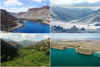
Band-e Amir National Park is located in the central Bamyan Province of Afghanistan. It was established on 22 May 2009 as Afghanistan's first national park to promote and protect the natural beauty of a series of intensely blue lakes created by natural dams high in the Hindu Kush. Band-e-Amir is a chain of six lakes in the southern mountainous desert area of the national park. The lakes formed from mineral-rich water that seeped out of faults and cracks in the rocky landscape. Over time, the water deposited layers of hardened mineral (travertine) that built up into walls that now contain the water. The Balkh River originates here and flows to Balkh Province in the north.

Environmental issues in Afghanistan are monitored by the National Environmental Protection Agency (NEPA). They predate the political turmoil of the past few decades. Forests have been depleted by centuries of grazing and farming, practices which have only increased with modern population growth.

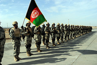
Below is the disposition and structure of international military forces that were participating in the War in Afghanistan in November 2012, listing deployed units under the command of the International Security Assistance Force (ISAF), which controlled both combat and reconstruction operations. During its existence from 2001 to 2014, despite the photos in this article only showing American soldiers, marines and sailors, the ISAF comprised units from many countries, including: Albania, Armenia, Australia, Belgium, Canada, Croatia, Czech Republic, Estonia, Finland, France, Georgia, Germany, Hungary, Italy, Latvia, Lithuania, Macedonia, Netherlands, New Zealand, Norway, Poland, Romania, South Korea, Spain, Sweden, Turkey, United Kingdom and others. In this article, units are assumed to be from the United States unless otherwise stated. This list is a rough and unofficial listing of units and formations.

Ayna Television was the first commercial television station broadcasting from Mazari Sharif, Afghanistan, starting in 2004 until 2022. The name Ayna means "mirror" in Uzbek. It aired entertainment and news programs as well as serving as an improvement tool for Abdul Rashid Dostum and his party, Junbish-i-Milli Islami Afghanistan, and at one point was reportedly owned by him. Ayna was set up in order to satisfy the entertainment needs of people in northern Afghanistan where Uzbek is widely spoken, but after a few years also started programmes in Dari Persian and Pashto languages.

The following outline is provided as an overview of and topical guide to Afghanistan:

Mining in Afghanistan was controlled by the Ministry of Mines and Petroleum, prior to the August 15th takeover by the Taliban. It is headquartered in Kabul with regional offices in other parts of the country. Afghanistan has over 1,400 mineral fields, containing barite, chromite, coal, copper, gold, iron ore, lead, natural gas, petroleum, precious and semi-precious stones, salt, sulfur, lithium, talc, and zinc, among many other minerals. Gemstones include high-quality emeralds, lapis lazuli, red garnet and ruby. According to a joint study by The Pentagon and the United States Geological Survey, Afghanistan has an estimated US$1 trillion of untapped minerals.
The Afghan Border Force (ABF) was responsible for security of Afghanistan's border area with neighboring countries extending up to 30 miles (48 km) into the interior and formed part of the Afghan National Army. In December 2017, most of the Afghan Border Police (ABP) personnel of the Afghan National Police were transferred to the Afghan National Army to form the Afghan Border Force. The ABP retained 4,000 personnel for customs operations at border crossings and international airports such as checking documents of foreigners entering the country or deporting them.
Tourism in Afghanistan is regulated by the Ministry of Information and Culture. There are at least 350 tourism companies operating in Afghanistan. Tourism was at its peak before the 1978 Saur Revolution, which was followed by the decades of warfare. Between 2013 and 2016, Afghan embassies issued between 15,000 and 20,000 tourist visas annually. Following Taliban's return to power in August 2021, visitor numbers gradually increased from 691 in 2021 to 2,300 in 2022, reaching 7,000 in 2023.
The Kunduz River is a tributary of the Amu Darya in northern Afghanistan. It rises in Bamyan Province in the Hindu Kush, and in its upper reaches is also known as the Bamyan River or the Surkhab River. After passing through Baghlan Province and Kunduz Province, the Kunduz River merges into the Amu Darya.

General Khodaidad is a former Minister of Counter Narcotics of Afghanistan.
Lists of Afghan provincial governors include a list of the current governors of provinces of Afghanistan, a list of governors appointed by the Taliban, and lists of governors of each province.

The East Afghan montane conifer forests ecoregion covers a series of unconnected conifer forests along the border between Afghanistan and Pakistan, at elevations of 2,000 metres (6,600 ft) to 3,400 metres (11,200 ft) above sea level. The ecoregion supports the near-threatened Markhor (Capra falconeri chiltanensis), known as the Screw-horned goat, the national animal of Pakistan. The forests of the ecoregion have been heavily thinned for timber.

The central Afghan highlands, or the Afghan Highlands, is a geographic region of Afghanistan. Stretching from the Sabzak Pass near Herat in the west to the Little Pamir in the northeast, it includes the main Hindu Kush range and forms a western extension of the Himalayas. It is a highland area of more than 1,500 m above sea level, mostly situated between 2,000 and 3,000 m, with some peaks rising above 6,400 m. Usually, the valley bottoms in the area are used for cereal and horticultural production, and the mountains and high plateaus are used as pasture in summer for grazing sheep, goats, cattle, and camels. Its total area is about 414,000 km2.
References
- ↑ UNEP-WCMC (2021). Protected Area Profile for Afghanistan from the World Database of Protected Areas. Accessed 15 August 2021.