Transportation in Laos consists of road, rail, air, and inland water networks that are shaped by the country's mountainous terrain and landlocked geography. While Laos has expanded its transportation infrastructure in recent decades overall connectivity remains limited compared with other Southeast Asian countries.[1]
Because of its mountainous topography and lack of development, Laos has few reliable transportation routes. This inaccessibility has historically limited the ability of any government to maintain a presence in areas distant from the national or provincial capitals and has limited interchange and communication among villages and ethnic groups. "BTI 2024 Laos Country Report". Bertelsmann Stiftung Transformation Index. 2024. Retrieved January 21, 2025.
The Mekong and Nam Ou are the only natural channels suitable for large-draft boat transportation, and from December through May, low water limits the size of the draft that may be used over many routes. Laotians in lowland villages located on the banks of smaller rivers have traditionally traveled in pirogues for fishing, trading, and visiting up and down the river for limited distances.[citation needed]
Otherwise, travel is done by ox-cart over level terrain or by foot. The steep mountains and lack of roads have caused upland ethnic groups to rely entirely on pack baskets and horse packing for transportation.[2]
The road system is not extensive. A rudimentary network begun under the French colonial rule and continued from the 1950s, has provided an important means of increased intervillage communication, movement of market goods, and a focus for new settlements. As of mid-1994, travel in most areas of Laos were difficult and expensive, and most Laotians traveled only limited distances, if at all. As a result of ongoing improvements in the road system started during the early 1990s, it is expected that in the future villagers will more easily be able to seek medical care, send children to schools at district centers, and work outside their villages.[citation needed]
Currently, there are several projects to develop transport networks.[3][4]
The 2021 completion of the Boten–Vientiane railway, the Lao section of the Laos–China Railway (LCR), connects Vientiane to Kunming.[5] The railway has transported more than 500,000 passengers from 115 countries and regions since passenger service was launched in April 2023; China doubled cross-border passenger train services in 2025.[6]
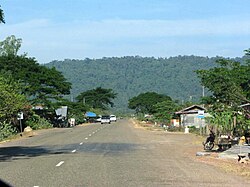
Highways
National Road 13 South
In Laos, there are 59,963 kilometres (37,259mi) of roadway, with 1.45% paved with concrete, 12.03% with asphalt concrete and 75.77% with double bituminous surface treatment and 10.75% with gravel road. [7]Right-hand traffic (RHT) is observed in Laos.[8]
Laos constructed a new highway in 2007 connecting Savannakhet to the Vietnamese border at Lao Bao, with funding from the Japanese government.[9] This has greatly improved transport across Laos. This highway can be traversed in a few hours, while in 2002 the trip took over nine hours.
Laos opened a highway connection to Kunming in April 2008. The Fourth Thai-Lao Friendship Bridge opened to the public on 11 December 2013 linking Kunming to Bokeo, Laos and Chiang Rai. It reduced travel time to five hours.
Expressway
Vientiane toll station of the Vientiane–Boten Expressway
On 20 December 2020, the Vientiane–Vang Vieng Expressway, the first expressway in Laos, was completed.[11] Construction began at the end of 2018 and was initially scheduled to finish in 2021. The road, which includes twin tunnels almost 900 metres long through Phoupha Mountain, shortens the route by 43km as compared with the existing Route No 13. The expressway toll is 550 kip per kilometre, or about 62,000 kip for a one-way trip between Vientiane and Vang Vieng. The Vientiane-Vang Vieng expressway is the first section of a planned expressway from Vientiane through the northern provinces to Boten in Luang Namtha Province, which borders China.[12]
About 4,600 kilometres (2,900mi) of navigable water routes exist in Laos, primarily the Mekong and its tributaries. There are an additional 2,900 kilometres (1,800mi) of water routes, which is sectionally navigable by craft drawing less than 0.5 metres (1ft 8in).[8]
Laos has an ocean-going merchant marine that consisted of one cargo ship of 2,370gross tonnage(GT) in 2004,[13] and still consisted of one ship in 2023.[8]
Pipelines
Laos has 136 kilometres (85mi) of pipelines for the transport of petroleum products.[14]
Laos possesses 52 airports, of which nine have paved runways. Of the airports with paved runways, Wattay International Airport in Vientiane has a runway length of 3,000 metres (9,800ft). Of the remainder, four have runways 1,524 metres (5,000ft) to 2,437 metres (7,995ft) length, and a further four have lengths between 914 metres (2,999ft) and 1,523 metres (4,997ft).[citation needed]
Of the airports without unpaved runways, one has a runway length of more than 1,524 metres (5,000ft). Seventeen have runway lengths between 914 metres (2,999ft) and 1,523 metres (4,997ft), leaving 25 with a lengths below 914 metres (2,999ft).[citation needed]
This page is based on this Wikipedia article Text is available under the CC BY-SA 4.0 license; additional terms may apply. Images, videos and audio are available under their respective licenses.


